Map Thread XXII

Welcome, ladies and gents, to the twenty-second version of the Map Thread! The place for all your mapping needs!

Sadly XXI took too darn long to get done so this had to be made in 2023. Oh well.

Relevant links:

Past map threads-
21: December 2021 to June 2023 (fluttersky; 500 pages)
20: July 2020 to December 2021 (Balkanized U.S.A; 499 pages)
19: July 2019 to July 2020 (water123; 497 pages)
18: July 2018 to July 2019 (FesteringSpore; 502 pages)
17: September 2017 to July 2018 (Upvoteanthology; 500 pages)
16: August 2017 to September 2017 (Upvoteanthology; 79 pages)
15: January 2017 to August 2017 (rvbomally; 499 pages)
14: March 2016 to January 2017 (MorningDew; 500 pages)
13: February 2015 to March 2016 (Red Arturoist; 497 pages)
12: February 2014 to February 2015 (Baconheimer; 497 pages)
11: April 2013 to February 2014 (Red Arturoist; 500 pages)
10: August 2012 to April 2013 (metastasis_d; 501 pages)
9: December 2011 to August 2012 (Vexacus; 500 pages)
8: June 2011 to December 2011 (Burton K Wheeler; 502 pages)
7: October 2010 to June 2011 (Ian the Admin; 499 pages)
6: September 2009 to October 2010 (Ian the Admin; 544 pages)
5: November 2008 to September 2009 (Ian the Admin; 501 pages)
4: May 2008 to November 2008 (Ian the Admin; 326 pages)
3: September 2007 to May 2008 (Ian the Admin; 321 pages)
2: October 2006 to September 2007 (Ian the Admin; 263 pages)
1: February 2005 to October 2006 (Diamond; 301 pages)

Other related threads-
Wikibox thread VI
WIP map thread
Sh*tpost map thread
Proposals and war aims that didn't happen map thread
Horrible educational maps thread
Q-BAM thread; Historic Q-BAM thread; M-BAM thread; XK-BAM thread; VT-BAM thread
OTL election maps thread
Alternate electoral maps thread
Photos from Alternate Worlds

As Fluttersky once said, "Let the mapping begin!"
 
Last edited:
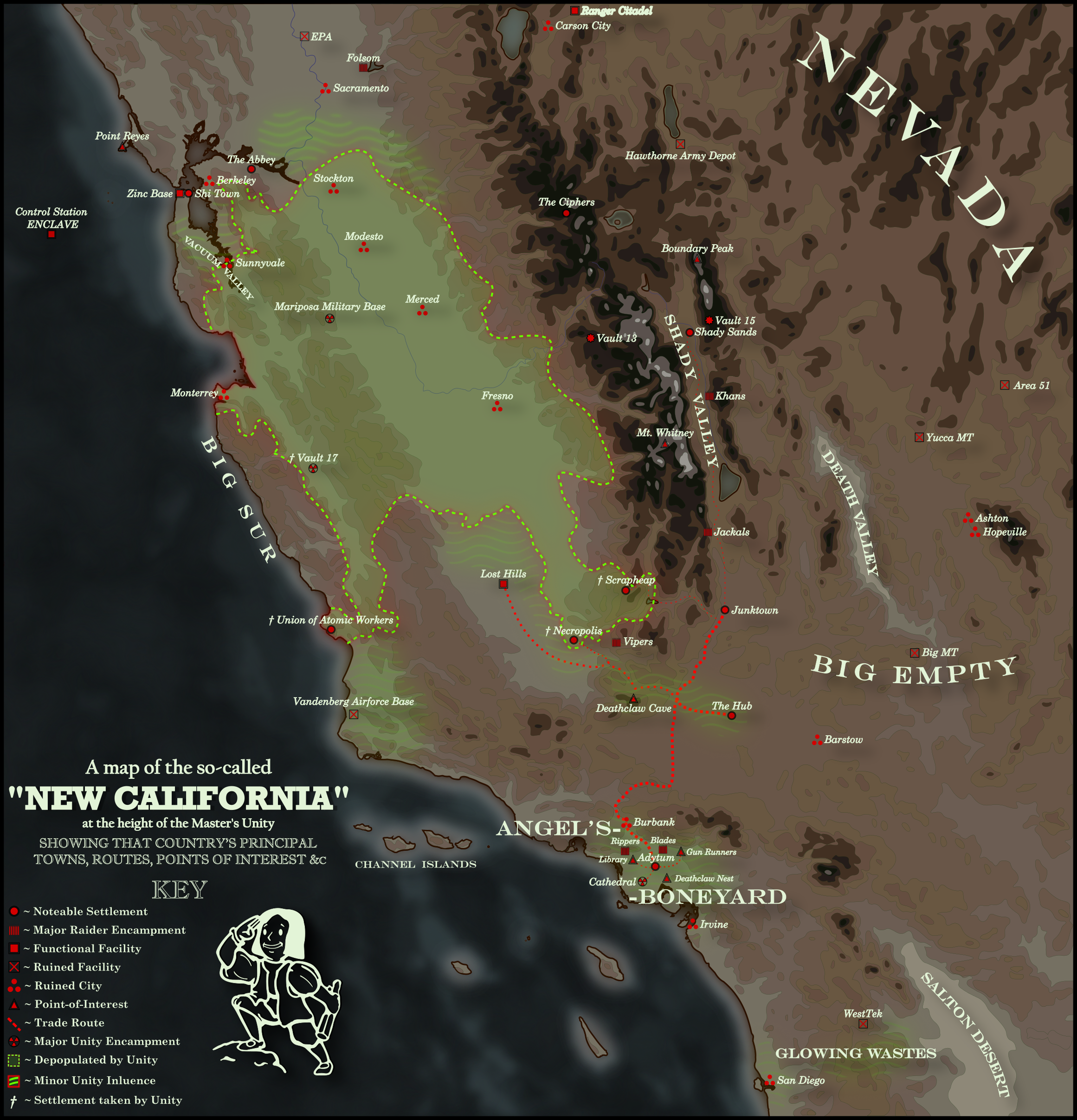
Map of the Unity at its height (AD 2162)


Map of the Unity at its Height

www.youtube.com/watch?v=dn3UDy…

Civilization in the Central Valley of California was strangled in its cradle. In the time before, when California sprouted great cities of pipe and steel, the valley was the breadbasket of the West, a vast plain fruited with every delicious thing. It was a teeming garden whose cultivation drove America forward. Then came the end. Black and orange trees sprouted on the horizon, wheat waved in spreading fire. Torrents of black burning rain came down, drowning great cities.

These things the Central Valley shared with much of the world. But there was one fact of its form that set it apart from much of the world. Shaped as a great bowl, in the 20th century the valley was beset by choking smog, unable to escape over California's vast mountains. And after the War, the Central Valley became a great pool of irradiated fallout in its air. Radiation cycled out more slowly here than it did elsewhere, in turn slowing the regrowth of plant life. The soil eroded, kicking up great storms of radioactive sand and dirt. The Central Valley of California became a vast desert, an irradiated dustbowl.

Mutants were a constant threat. The festering fallout of the War and the rotting hearts of old-world cities conspired to create untold horrors. This would be bad enough if it were not for an ancient ruin towards the center of the great valley, leeching a strange brew into the soil and water table around it, accelerating the rate of mutation.

Progress was slower here than it was in southern California, yet there progress there was. Farmsteaders clung to the banks of the San Joaquin and the Sacramento, grim butchers of men and mutants made their savage living. Ingenious tule-eaters huddled in vast mud flats, the shambling horrors of the Necropolis eked out a living. Metallic monks occulted themselves in study, motorbiking nomads ranged the sand dunes around Sacramento. The agricultural poverty of the valley was dampened the attraction of interaction for the budding societies of southern California, but some enterprising individuals still crossed the Tehachapi mountains to make contact and conduct commerce. As the years wore on, higher levels of trade and development were frustrated by vast populations of mutants. It was a seeming paradox - as time wore on, when the rest of the world healed and returned to something resembling normal, the creatures of the Central Valley grew stranger and more hostile. The caravan masters of the rising Hub, hearing tales of a dark heart of corruption in the north, resolved to send an expedition to solve this problem...

The southerners never received an answer to their question. It became just one more of the countless mysteries in the new world. Life went on, things grew and changed. Populations grew in the south.

In the Owens Valley, soon to take the name of the Shady Valley, rivers and lakes were filled for the first time in centuries, freed from the thirst of old Los Angeles. Farming villages sprouted, inevitably attracting predators - the savage Khans, the degenerate Jackals, among many others. The ranchers of Junktown encamped towards the mouth of that valley and the Isabella Valley, serving as an entrepôt between those agrarian communities and the bustling Hub.

To the west of the Hub was was vast desert. Despite tales of lost cities and mountains inhabited by gods, the people of the Hub knew it only to be inhabited by gecko-eating savages, a big empty nothing. They were more interested in the lands in the further south. The L.A. Boneyard stretched forever, the skeletons of buildings lying under the hot sun. Soils composed of crumbled concrete and shattered glass proved inhospitable to agriculture, and yet it was replete with clans who made their living by hunting on the one hand, and scavenging on the other. Not so much for advanced technology and finished products, though there was a lucrative trade in these, but for raw materials - steel, chiseled stone, copper wire, glass, all of this could go for a fortune. Some ingenious gangs turned these raw materials towards manufacturing. It was a violent and desperate place, replete with blood and horror, but even here there was hope.

Down the broken coast, past the looming re-purposed old world Cathedral, there was little of note. There were strange rumors on the banks of Irvine - a colony of thinking mutants, a city of robots, a pristine office building from the old world, but these were just rumors. The land grew more hostile the further south you went and the inhabitants more debased until you were met the triple-desolation of old San Diego, the Glowing Wastes, and the bone-strewn Salton Desert.

Back to the north, there were fisher clans and raiders up to the Modoc Valley, where still glowed in the night. Vandenberg Airforce, destroyed first in the War, and a second time in conflict by the Union of Atomic Workers. The Union, based in Diablo Canyon Nuclear Power Plant, was one of the most technologically advanced societies in the wasteland, and yet they were even more committed to isolation than the Brotherhood to the east. Just as they had destroyed Vandenberg in conflict, they would be destroyed by the arrival of the Mutant Army, their advanced technology pilfered, their cooling towers shattered, a bare remnant surviving in hidden tunnels beneath the earth.

It was a common story. Ever year, another wave of settlements went dark, supposed destroyed by hunger and mindless mutants. The Salter people of the Salinas Valley were annihilated, the Vault and settlement at King City turned to one of history's greatest horrors - just one of many vaults cracked open for its Prime Normals. The scavengers of Scrapheap fled in the night when sentries saw the mutants coming. The Yakuza of San Francisco attempted to stem the evil at its source, and lost their home for it. The Tule-Eaters, the ghouls of Necropolis, the Army of God, the Camper Clans, the Glass Walkers. Most of the peoples destroyed by the Unity would be lost to history, their names never uttered again. They fled to the four corners, coming to new lands and mountain holdfasts. Mostly, they starved, they fell prey to beasts and raiders, they became raiders themselves, they were absorbed into other peoples.

The number of trade routes drawing merchants to the central valley declined to a bare handful. When Necropolis and Scrapheap went dark, there was only one left of note. Few in the south knew the true nature of the looming threat beyond Tejon Pass, and the undermining influence of a strange new cult. The coming conflict would determine not only the fate of California, but perhaps the world...

--------------------------------------------

The basic idea of this started with the idea I had in my head that the Super Mutant expansion would end up being something like the Mfecane, depopulating the central valley and spawning waves of migration and conflict. It ended up becoming more of a bog-standard Fallout 1 era map, but I'm pretty happy with how it came out.

One thing I'm not entirely happy with is how the topography came out. If anyone has any recommendations to spruce this up going forward, let me know.
 
Long live the new Map Thread, have fifteen different Virginias!

Fifteen Virginias.png


A1 – The Dominion of Virginia

Capital: Richmond
Government: Federal parliamentary constitutional monarchy in personal union with the United Kingdom of Great Britain and Ireland

The Dominion of Virginia occupies a peculiar position in Anglophone North America. For one, it is the second-largest of them in terms of area, only surpassed by the massive yet sparsely populated Rupertia (which Virginia barely borders in the north). Secondly, it is the second-most populated Anglophone state on the continent, only surpassed by its northeastern neighbor New Britain.

What really sets Virginia apart is its continued loyalty to the British crown in an era where republicanism is spreading on the North American continent. Besides the aforementioned Rupertia, it is the last remaining state still in union with the UK in the region. Alebamon, Canada, Carolina, the Haudenosaunee Confederacy, New Britain, and Tsalagihi-Cumberland have all cut their ties with their “mother country” over time, but the Old Dominion stays proud!

With its vast territories surrounding the southern portions of the Great Lakes and its rich mining history along the Allegheny mountains, Virginia has become a wealthy and diverse nation. However, while its populace remains loyal to the crown, dissatisfaction with the Westminster-style system of government has increased drastically, both in the indigenous provinces (which are only represented in the upper house, the Chamber of Provinces) and in the urban areas, where a greater diversity of parties leads to most constituencies in the Chamber of Deputies being elected with less than forty percent of the vote.

A2 – The United Commonwealth of Virginia and Kentucky

Capital: Fort Jefferson (OTL’s Charleston, WV)
Government: Confederated constitutional republic with an executive president

The United Commonwealth is a buffer state, and it knows it. Located between the United States of North America to its north and the Confederated Provinces of Columbia, Virginia and Kentucky provides these two massive neighbors the distance they need to not get at each other’s throats.

Virginia and Kentucky, like Columbia, was founded as a slaver society, however contrary to it they abolished this practice in the 1850s due to a lack of profitability and growing difficulty to sell its cotton and tobacco through the massive ports of the United Provinces.

Since the abolition of slavery, the United Commonwealth became an important provider of coal and steel to Columbia’s small industrial sector, as well as the most important whisky producer of North America. Only during the 1940s did Virginia’s economy significantly diversify with a small yet influential tech industry, as the Arlington-based company Silver Star Electronics was a pioneer in establishing new audio formats, such as the Audio Cart.

Today, the United Commonwealth has a healthy mixed economy, but the confederal structure between the two constituent commonwealths has led to some political deadlock regarding environmental legislation and electoral reform.

A3 – Tsenacommacah Confederacy

Capital: Werowocomoco (OTL’s Gloucester Courthouse, VA)
Government: Confederated constitutional monarchy

The Tsenacommacah Confederacy, sometimes in older texts known as the Powhatan Confederacy due to that nation’s dominance within this state, is one of several states of Florida (OTL’s North America) with an indigenous majority and leadership. During the colonial era, the Tsenacommacah Confederacy was under protection of the Kingdom of England, which established several trade forts in the area and even took over the northern sections of the northern sections of the Accomac Peninsula, which today forms the Free Commonwealth of New Cornwall.

The colonial era also saw widespread Christianization of the Tsenacommacah people, largely adopting English-style Protestantism, although the Mamanatowick (its head of state) only nominates the Archbishop of the Tsenacommacah as a lifetime appointment, rather than serving as head of the faith like the monarch of England does to this day.

The Confederacy today is an important state in Florida despite its small size, often serving as the host of the Florida Convention and with the Mamanatowick often serving as an arbitrator for disputes in the western hemisphere. Economically the Confederacy is largely agricultural, though services, fishing, and light manufacturing are also important. As a result, the country is often labeled as a semi-developed country.

A4 – Republic of Piedmont

Capital: Edenton
Government: Unitary presidential republic

The Republic of Piedmont is one of several republican successor states when the British control over their North American possessions collapsed in the 1810s. Founded as a union of the colonies of Virginia and North Carolina, which had very similar economies and degrees of urbanization, Piedmont became stuck between the Palmetto Republic, the tiny yet fierce slaver state, and the United Provinces of Liberia, which together with the various New Englander states founded the hotbed of the abolitionist movement on this side of the Atlantic.

While originally an almost aristocratic state dominated by large landowners, a rise of populist politicians in the 1870s both led to the final abolition of slavery in Piedmont, as well as increased democratization. For example, the president became limited to one six-year term instead of multiple non-consecutive five-year terms, and the House of Representatives shifted from a constituency-based model to a proportional model, while the House of Communities remained a constituency-based chamber.

Economically Piedmont is often seen as being stuck as being a primary economy. With sizable farming communities, mining operations, and a healthy fishing sector, Piedmont is perfectly able to feed itself. It also hosts a light manufacturing and a small local entertainment industry. Regarding the latter, Piedmont is home to a significant horse breeding and horse racing sector in its westernmost sections, the Bluegrass region.

Politically Piedmont has a healthy two-and-a-half party system.

A5 – Republic of Virginia

Capital: Richmond
Government: Unitary semi-presidential republic

Virginia is one of the powerhouses of North America. Standing on its own since the Liberty Revolutions of the late 18th century, Richmond utilized its vast western territories as a draw to attract European migrants far more effectively than the more urbanized United States of Fredonia to its northeast or the slavery-dependent Confederation of Southern States, despite only having one good port for processing transatlantic migrants with Norfolk.

During the second half of the 19th century, Virginia transitioned from a mostly agrarian society to a mixed one with sizable industry, mostly centered on the Trans-Allegheny and the southern shores of the Great Lakes, like the massive border city of Chicago, opposite the Canadian province of Huron and just south of the border to the Confederation of Indiana.

Politically Virginia is a haven of liberalism. The state allows for great degrees of personal and economic freedom and contrary to the CSS it has a much better civil rights record for its black minority. However, Virginia also bears the legacy of widespread “Indian removal” in its territories north of the Ohio River, which has led to terrible relations with Indiana until the 1980s, when Richmond began to acknowledge and act on this tragedy largely committed by the Virginian political elites and their willing pawns settling in the country’s north.

B1 – Free State of Virginia

Capital: Richmond
Government: Constituent state of a federal presidential constitutional republic

During the American Civil War Frederick County actively participates in the May 28 election of 1863 in Restored Virginia, ultimately leading to its inclusion in West Virginia.

The remainder of Virginia, after the Civil War, mostly follows the history of our timeline. While experiencing a few years of political weirdness during Reconstruction (which even involved the state ditching the traditional “Commonwealth” label in favor of “Free State”), Virginia first becomes a Solid South state and a hotbed for segregationist politicians.

However, during the civil rights era, Virginia quickly begins moving towards a progressive direction. union-supported politicians are frequently elected from the coastal and northern cities. The Democratic Party has become rather unpopular, mostly being elected in southern districts bordering North Carolina, instead the Republican Worker’s Party has gained political dominance thanks to these union-affiliated voters and candidates.

Economically, the state benefits greatly from bordering Washington, D.C., and thus is important for the arms and aerospace industries. Still, farming and seafood are also important, and Virginia is the most important wine producer state west of the Mississippi.

B2 – Sovereign Commonwealth of Virginia

Capital: Richmond
Government: Unitary parliamentary herrenvolk republic

While the Confederate States of America narrowly managed to achieve their goals in the Southern War of Independence, certain territorial loses were inevitable just to avoid the United States from further activating its industrial base. Ultimately the CSA lost sizable parts of Virginia, even beyond the parts that were part of “Reorganized Virginia”, as well as the eastern third of Tennessee, as well as the rights to Kentucky, Missouri, Arizona/New Mexico, and the Neutral Strip west of the Indian Territory (which stayed with the Confederacy).

Despite this victory, the CSA would not last long. Authoritarian factions gained prominence over the young country. The clash between the “idealistic” states and the “nationalist” core eventually became the Confederate Civil War. Ultimately the rump of Tennessee and Arkansas rejoined the USA, while the “idealistic” states of Florida, Louisiana, North Carolina, and Texas gained independence. Virginia became separated from the nationalist core and ultimately gained its own independence in 1897.

The Sovereign Commonwealth of Virginia today is the last remaining state that still follows the Confederate ideals: strict segregation, a strong central government, protectionist trade policies, and a preference towards agriculture over different economic sectors. However, Virginia did bring one innovation, the creation of the “Autonomous Negro Counties”, consisting of the old counties of Sussex, Nottoway, Amelia, and Cumberland. Black Virginians outside of this administrative unit are subjected to highly restricted movement and employment, but the ANCs themselves are left deliberately destitute by the national government in Richmond.

B3 – State of Allegheny & Commonwealth of Virginia

Capital: Charleston (Allegheny) & Richmond (Virginia)
Government: Constituent states of a federal presidential constitutional republic

The antebellum United States was a nation fraught with the constant need for compromise. When it became clear that there was a sizable desire to annex additional lands in northern Mexico to ease the construction of railroad routes to California, the Southern states made clear that they were hoping for additional slave states to be established in these territories. However, in the interest of balance, anti-slavery Virginians began voicing their desire to leave Virginia, pointing out that the Trans-Allegheny but also parts of the Valley rely far less on slavery than the Piedmont and the Tidewater.

Ultimately Virginia was divided peacefully, officially to counter-balance the admission of the slave states of Rio Grande and Yucatan. The new state of Allegheny would become an important mining state and an important left-wing voice in the USA (albeit one with a greater focus on the “white working-class”), while the remaining Virginia, after the disastrous experiment of the War of Secession, would end up being a mixed economy and an important state for liberals in the country-at-large.

B4 – Free State of Virginia

Capital: Richmond (also national capital until 1909)
Government: Constituent state of a confederal non-partisan herrenvolk presidential republic

Virginia is an important puzzle piece in understanding the Confederate States of America, the pariah of the western hemisphere. Situated in the country’s north, the state borders three different states (Maryland, Kanawha, and Kentucky) belonging to the Confederate’s hated neighbor, the United States. Virginia is also home to several important figures in both United States and Confederate history, most notably George Washington, first president of the USA when it was still a united slavocracy itself. The connection to Washington can be seen on the Virginian flag, which features the three red stars found on the coat of arms of the Washington family, of which Virginia’s most famous son who served under the Confederate flag, General Robert E. Lee, was a distant member of.

Within the Confederacy Virginia initially served as a power center. Its state capital Richmond served as the national capital from 1861 to 1909, before being replaced by Greenville (South Carolina). Virginia also serves as one of the four industrial states in the Confederacy, though it lacks behind the powerhouses of Tennessee and Texas.

Virginia is also within the lower half in terms of the percentage of Black Confederates living in its territory, ranking seventh out of twelve.

B5 – Commonwealth of Virginia

Capital: Richmond
Government: Constituent state of a federal presidential constitutional republic

The 1831-1832 session of the Virginia House of Delegates is deemed one of the most important legislative sessions in Virginia history, if not of the entire United States. Prompted by a slave uprising in August 1831 led by an individual named Nat Turner, the House of Delegates ultimately prepared and passed an emancipation plan for the state and presented it to the Virginian public in late September 1832.

The pro-emancipation campaign ultimately was successful, arguing that abolition would decrease idleness in the state elites, would remove the danger of future slave uprisings (especially in the context of foreign invasion), and lackluster economic performance in Virginia compared to other states. The campaign did noticeably include the component that the Black population in Virginia was to be reduced by one quarter by encouraging greater colonization of the Freedman colonies in Liberia, but ultimately Virginia, while not becoming a hotbed for the civil rights of Black Americans, did become a “free” state at the end of the 1830s.

Slavery would be gradually phased out in the United States over the next thirty years, ending in 1869 when Mississippi and Alabama abolished the practice and the enforcement of emancipation in the revolting states of South Carolina and Florida was completed. Now Virginia is a massive and diverse state, with the second-most powerful economy on the East Coast behind New York. Politically the state does feel certain tension, as the mountain towns in the west and the factories along the border with Maryland are hotbeds of union sentiment, while the rest of the state Is still rather conservative.

C1 – Norfolk District

Capital: Norfolk

Government: Administrative district in a unitary presidential republic under a military junta

The establishment of military rule in the United States in 1938 created a series of massive changes. As civil liberties were eroded under the MacArthur administration, the importance of the individual states that made up the union began to steadily decrease, too. While never formally abolished (which would prove useful during the return to popular rule in 1986), the states were largely replaced by districts that were much larger and were deliberately named after their administrative center to discourage identification with it.

The Norfolk District on the East Coast was often seen as a model district by the military administration. While in 1951 MacArthur moved the national capital to St. Louis and away from Washington, the coastal areas of the Norfolk District would continue to house several federal administrative structures. For example, the SWAN Building, itself former headquarter of the War Department, continued to be used for bundling command east of the Mississippi.

After the return to democracy in the 1980s, the Norfolk District would remain with the re-democratized United States of America, though there was serious debate about whether the state of South Carolina would join the Republic of New Afrika, one of the four successor states in the continental states. Ultimately it didn’t, leaving the states that, in whole or in part, made up the Norfolk District, as border states.

C2 People’s Commonwealth of Chesapeake

Capital: Baltimore
Government: Constituent state of a federal one-party directorial parliamentary socialist republic

While the late 19th century was seen by contemporaries as an opportunity for the Progressive movement to gain political dominance in the United States, however what historians would call the Gilded Age did not end in marginal reforms, but violent uprising. The Bourbon Democrats managed to fend of William Jennings Bryan’s attempt to take control of the party, while the Republican Party also saw fervent battles about ideology. This atmosphere allowed the nascent socialist movement in the USA to flourish in the background, and in the early 1910s the young Socialist Party of America saw massive groundswell. After massive voting irregularities in the 1912 election, the December Revolutions began to sweep across America.

After a three-year civil war, the people had won. The new socialist administration would develop massive policies designed to combat the systemic weaknesses of the old capitalistic regime. One of these was the redrawing of administrative boundaries. While local identity was seen as an important factor, it was decided that some reorganization was necessary, allowing the new “people’s commonwealths” to be based on which cities served as gravitational centers for the area.

Chesapeake, for example, centered on the historic capital of Washington, D.C., and while Washington was replaced as the national capital in favor of Chicago, Chesapeake was designed to be an important hub for maritime culture, containing the important ports of Baltimore and Norfolk, and with loads for fertile farmland and several factories producing everything from military equipment to kitchen appliances, Chesapeake became an important driver in the USSA’s economy, which it remains to this day, frequently competing with New York for the title of most important people’s commonwealth east of the Mississippi.

C3 – Popular Commonwealth of Virginia

Capital: Richmond
Government: Constituent state of a federal presidential constitutional republic

In the aftermath of the American Civil War, reconstruction in the state of Virginia took an interesting and unique turn. For one, two counties which during the Civil War had voted to join West Virginia, Berkeley & Jefferson, were returned to Virginia via Supreme Court decision in 1870. Furthermore, the Readjuster movement and party emerged in the 1870s, successfully advocating for the end of the continued dominance of the white planter class without alienating the white majority itself. Former Confederate general William Mahone, who had experience in the railroad industry and wanted to see Virginia thrive, became one of the leaders of the movement.

A key policy was to divide the debt which Virginia held among it and West Virginia based on the proportional population of the two states that succeeded antebellum Virginia, which proved successful and gave Virginia the possibility to heavily invest into infrastructure and education, especially for black students. The biracial coalition built by the Readjusters was remarkable, in fact the only Virginia, Louisiana, and South Carolina achieved similar circumstances.

Virginia as a result would become a beacon of black culture and saw the emergence of a statewide black middle class that was unprecedented, especially considering how Louisiana would backslide into a white supremacist mode of governance in the 1890s and South Carolina would remain a largely agricultural state.

Today Virginia is often seen as one of the naturally progressive states, although one also renowned for a populist rhetoric that doesn’t mince words and which at times is socially more conservative regarding topics such as queer rights, which continue to be hotly debated in the state.

C4 – Fraternal Commonwealth of Virginia

Capital: Richmond
Government: Constituent state of a federal theocratic presidential Christian republic

America is a Christian nation. After nearly six decades of the rise of the Moral Majority movement and forty-seven years since the passing of the Shining Constitution, this has become a fact on the global stage. America has at times withdrawn itself, limiting itself to soft power and conveniently ignoring its international boogeymen, the godless Soviets and Chinese, in order to strengthen control at home.

Virginia holds a special place in the American psyche of the day. Home to so many of America’s influential figures, including the revered but recently deceased former president Pat Robertson, and its proximity to the capital, Washington in Zion, has given it the status of a pilgrimage site for the good Christian patriots of America.

However, the status of states has greatly diminished. Education has become a national matter, with states only tasked to ensure that the schools within them teach the children no unholy doctrines and that social workers bring home-schooled children that have blasphemous parents back into the flock.

The same applies to most other affairs originally relegated to the individual states under the discarded constitution, which has been declared corrupted by secularists and deists. But Virginia is devout!

C5 – Commonwealth of Virginia

Capital: Richmond

Government: Constituent state of a federal presidential constitutional republic

The 2016 election of Hillary Clinton to the presidency was a surprise. Not to the media, which had seen her victory as almost assured, or the Democratic Party, which had worked tirelessly as an organization to ensure her nomination despite her unpopularity as a candidate even among sizable chunks of the party base.

The surprise was due to how narrow the election was. Having narrowly defeated the bumbling, crass business tycoon Donald Trump, several states that were battleground states began to experience a murmuring. Why should conservative voters stay in states that were almost always voting Democrat, even when, to them, the election was effectively a coin toss?

Virginia was one of the most affected states by this sentiment. VEXIT was the name adopted by the contingent of GOP voters in the western parts of the state, a not-so-clever variation of the BREXIT campaign that recently led to the UK leaving the European Union. Conservative counties and cities in Virginia began to quickly organize plebiscites on leaving Virginia, seeing their chance in joining West Virginia, a solidly Republican state (excluding the Blue Dog Joe Manchin serving as one of its two senators).

Several counties ended up voting for joining West Virginia, and surprisingly Virginia itself approved. The Democrat-dominated state legislature saw it as a potential to turn Virginia into a progressive coastal bastion like New Jersey. In the summer of 2019, the transfer was done. VEXIT was achieved. Virginia was now solidly blue, and West Virginia, eager to accept more territory in the hopes of revitalizing its struggling economy, eagerly accepted the new counties. “We have completed the project which began with the Second Wheeling Convention almost one-hundred-and-eighty years ago”, stated Jim Justice, the Democrat-turned-Republican governor who entered office in 2016, the same election that saw president Clinton enter the White House.
 
Welcome, ladies and gents, to the twenty-second version of the Map Thread! The place for all your mapping needs!

Sadly XXI took too darn long to get done so this had to be made in 2023. Oh well.

Relevant links:

Past map threads-
21: December 2021 to June 2023 (fluttersky; 497+ (still going, will be updated when finished) pages)
20: July 2020 to December 2021 (Balkanized U.S.A; 499 pages)
19: July 2019 to July 2020 (water123; 497 pages)
18: July 2018 to July 2019 (FesteringSpore; 502 pages)
17: September 2017 to July 2018 (Upvoteanthology; 500 pages)
16: August 2017 to September 2017 (Upvoteanthology; 79 pages)
15: January 2017 to August 2017 (rvbomally; 499 pages)
14: March 2016 to January 2017 (MorningDew; 500 pages)
13: February 2015 to March 2016 (Red Arturoist; 497 pages)
12: February 2014 to February 2015 (Baconheimer; 497 pages)
11: April 2013 to February 2014 (Red Arturoist; 500 pages)
10: August 2012 to April 2013 (metastasis_d; 501 pages)
9: December 2011 to August 2012 (Vexacus; 500 pages)
8: June 2011 to December 2011 (Burton K Wheeler; 502 pages)
7: October 2010 to June 2011 (Ian the Admin; 499 pages)
6: September 2009 to October 2010 (Ian the Admin; 544 pages)
5: November 2008 to September 2009 (Ian the Admin; 501 pages)
4: May 2008 to November 2008 (Ian the Admin; 326 pages)
3: September 2007 to May 2008 (Ian the Admin; 321 pages)
2: October 2006 to September 2007 (Ian the Admin; 263 pages)
1: February 2005 to October 2006 (Diamond; 301 pages)

Other related threads-
Wikibox thread VI
WIP map thread
Sh*tpost map thread
Proposals and war aims that didn't happen map thread
Horrible educational maps thread
Q-BAM thread; Historic Q-BAM thread; M-BAM thread; XK-BAM thread; VT-BAM thread
OTL election maps thread
Alternate electoral maps thread
Photos from Alternate Worlds

As Fluttersky once said, "Let the mapping begin!"

Aren't there still less than 500 pages on the old thread?

Either way, this one is off to a great start.
 
The idea is that some activity will continue on XXI to bring it up to 500 pages, in the meantime this one is getting a head start.
 
I'm not sure if that border for Lancashire is correct.

Sticht Utrecht and Oversticht were not seperate identities. Should be green.
TY, fixed
This is an amazing reference for us Early Modern enthusiasts, thank you so much
Included you in so you know this is now updated
That map clearly depicts Lancashire's border with Chester extending further east than your map does.

Nice map and I don't want to be that guy, but Dnieper and Volga reservoirs and Soviet administrative borders in Russia and Kazakhstan?
TY I have tried to get rid of the reservoirs but the Soviet borders are as good a guide in a borderless society ... unless you can show me different
Now I see what you mean
View attachment 839014
My first revision of Lancashire-Cheshire
From my own efforts, I think this border's closer - ignore Manchester eating a bit of Cheshire.
View attachment 839039
Superseded by a bit of the WorldRaj I've never seen before. TY, glad to re-unite it with the Welsh border from the same place.

wBTvnqb.png

Thank you everybody for your suggestions and help
 
The establishment of military rule in the United States in 1938 created a series of massive changes. As civil liberties were eroded under the MacArthur administration, the importance of the individual states that made up the union began to steadily decrease, too. While never formally abolished (which would prove useful during the return to popular rule in 1986), the states were largely replaced by districts that were much larger and were deliberately named after their administrative center to discourage identification with it.

The Norfolk District on the East Coast was often seen as a model district by the military administration. While in 1951 MacArthur moved the national capital to St. Louis and away from Washington, the coastal areas of the Norfolk District would continue to house several federal administrative structures. For example, the SWAN Building, itself former headquarter of the War Department, continued to be used for bundling command east of the Mississippi.

After the return to democracy in the 1980s, the Norfolk District would remain with the re-democratized United States of America, though there was serious debate about whether the state of South Carolina would join the Republic of New Afrika, one of the four successor states in the continental states. Ultimately it didn’t, leaving the states that, in whole or in part, made up the Norfolk District, as border states.

So, just a quick question or three: What happened in 1986, what states does New Africa consist of and what are the other post-military states?
 
So, just a quick question or three: What happened in 1986, what states does New Africa consist of and what are the other post-military states?
Roughly speaking, I envisioned New Afrika to just be Georgia, Alabama, and Mississippi.
Other posts-military states would be Florida, Pacifica (California, Oregon, Washington, Nevada, Idaho, and maybe Arizona..?), and probably Alaska, Hawaii, and Puerto Rico.

So the US would still control almost all of the Mississippi River watershed and most of the East Coast.
 
Superseded by a bit of the WorldRaj I've never seen before. TY, glad to re-unite it with the Welsh border from the same place.

Oh. I actually very deliberately altered things based to give a different border than historically by taking advantage of the marcher lordships. In particular I ended up annexing Maelor to Cheshire along with hthe rest of Flintshire, and did some different boundaries in Staffordshire and Herefordshire.
 
the_people_s_hammer_1957__post_war__by_amongthesatanic_d7fkhwv.png


The previous map and this one are two years (1937 and IIRC 1950) in my scenario The People's Hammer, a derivative of 'For All Time', which is available on my DeviantART account for those interested but essentially imagine if an ASB teleported the Great Revolutionary Peoples Hammer from 1970 FAT over the Western Front right before the final clash in our WW1, from there, things could only get worse....
 
Last edited:
1687480005011.png


Random WI: What if Edward I Longshanks successfully organised the dynastic union between England and Scotland by arranging the marriage between Edward II and Margaret Maid of Norway. This leads to a years earlier Union of the Crowns and no claim on France, which i chose by butterflies to go to Joan II of Navarre and by jure uxoris Phillip of Evreux.
 
View attachment 839463

Random WI: What if Edward I Longshanks successfully organised the dynastic union between England and Scotland by arranging the marriage between Edward II and Margaret Maid of Norway. This leads to a years earlier Union of the Crowns and no claim on France, which i chose by butterflies to go to Joan II of Navarre and by jure uxoris Phillip of Evreux.
Really interesting idea.
 
Top