You are using an out of date browser. It may not display this or other websites correctly.
You should upgrade or use an alternative browser.
You should upgrade or use an alternative browser.
The NextGen OTL Worlda Series
- Thread starter hadaril
- Start date
Is there a small-regular size WorldA with only national borders ?
The WorldA only has one size, the proto-WorldA that doesn't include most of the Pacific hasn't been used in a very long time.
With that said I do have a version of the map that only includes colors and national borders;
Thanks!The WorldA only has one size, the proto-WorldA that doesn't include most of the Pacific hasn't been used in a very long time.
With that said I do have a version of the map that only includes colors and national borders;
View attachment 888102
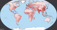
Does anyone have a population density map?
Aside from a density by country, autonomous territory and states one that I did in 2011, I don't think any exist.
Last edited:
There's a QBAM one that you might be able to downsize to fit in a world-a since they should be the same projectionAside from a density by country, autonomous territory and states that I did in 2011, I don't think any exist.
I can't attach it right since its apparently too big
Edit: I just did some quick testing and you lose some detail to pixels merging in the shrinking process, but it absolutely is doable to convert
Last edited:
found some linksDoes anyone have a population density map?
full image
from qbam thread
The Q-BAM Improvement and Core Thread
While working on my historical map I realized that the border between Alberta and British Columbia should match with the western border of Glacier County in Montana, I would try to fix this myself, but I don't know exactly where is the problem: Canada, the US counties or both
www.alternatehistory.com
you just have to re-size it down but the projection will fit
QBAM and WorldA aren't the same projection. From what I can tell, QBAM and nothing are the same projection. But it's good enough.There's a QBAM one that you might be able to downsize to fit in a world-a since they should be the same projection
I can't attach it right since its apparently too big
Edit: I just did some quick testing and you lose some detail to pixels merging in the shrinking process, but it absolutely is doable to convert
So after a very long time of procrastinating on this I finally got around to fixing the Spratly Islands; I also added an island off of Vietnam's coast and a small fix to part of the Bornean coast near-by.
Note that due to the sheer amount of islands controlled or claimed by so many states, and many so close to each other, I have shown the area as claimed by multiple sides.

Note that due to the sheer amount of islands controlled or claimed by so many states, and many so close to each other, I have shown the area as claimed by multiple sides.
Correct, plus downsizing the QBAM of course kills the shoreline.QBAM and WorldA aren't the same projection. From what I can tell, QBAM and nothing are the same projection. But it's good enough.
Worlda in Neon Green and gray, qbam in red, whites, blues:
I mean sure it could work as a off hand guide....
This is practically the same projection. Just need to chop up the world into a few subsections and stretch/shrink selection box width/height until the coastlines matchCorrect, plus downsizing the QBAM of course kills the shoreline.
Worlda in Neon Green and gray, qbam in red, whites, blues:
I mean sure it could work as a off hand guide....
Alright, so I've been doing some patches in the Japan area.
Fixes:
-Fixed the entirety of the Kuril Islands.
-Some fixes to China's coast in the Sea of Bohai.
-South Sakhalin.
-Added some islands near the coasts of Japan and South Korea.
-Fixed the size and position of Jeju Island.
-Corrected the Liancourt Rocks to be shown as controlled by S. Korea and claimed by Japan.
-Fixed the size and shape of some of the Japanese islands in the Sea of Japan.
-Removed a non-existent island near Hokkaido.
QBAM doesn't fit anyway, but maybe this could be better. It would only need correction for white areas like Hawaii and other minor islands.Correct, plus downsizing the QBAM of course kills the shoreline.
Worlda in Neon Green and gray, qbam in red, whites, blues:
I mean sure it could work as a off hand guide....
Attachments
made a rough map of the drainage divides of north and south america (mostly north, as wikipedia had a map for a few, while SA just had the continental divide)
source: https://en.wikipedia.org/wiki/Continental_Divide_of_the_Americas
It seems that in 2002 the Republic of China gave up claims to Mongolia. But it is not entirely clear whether they gave up Tuva? I mean the green border.
Forgive me for necroing these comments from two years ago, but given my recent cartographic spree, I really need to know if the Republic of China/Taiwan gave up their territorial claims in Mongolia and Tuva, if they actually did dropped their claims almost twenty two years ago, you would expect that they would at least have started to make updated maps, unlike the vast majority of them that still show their century-old border claims.I think they gave up Tuva and the Central Asian claims when the Soviet Union fell
Share: