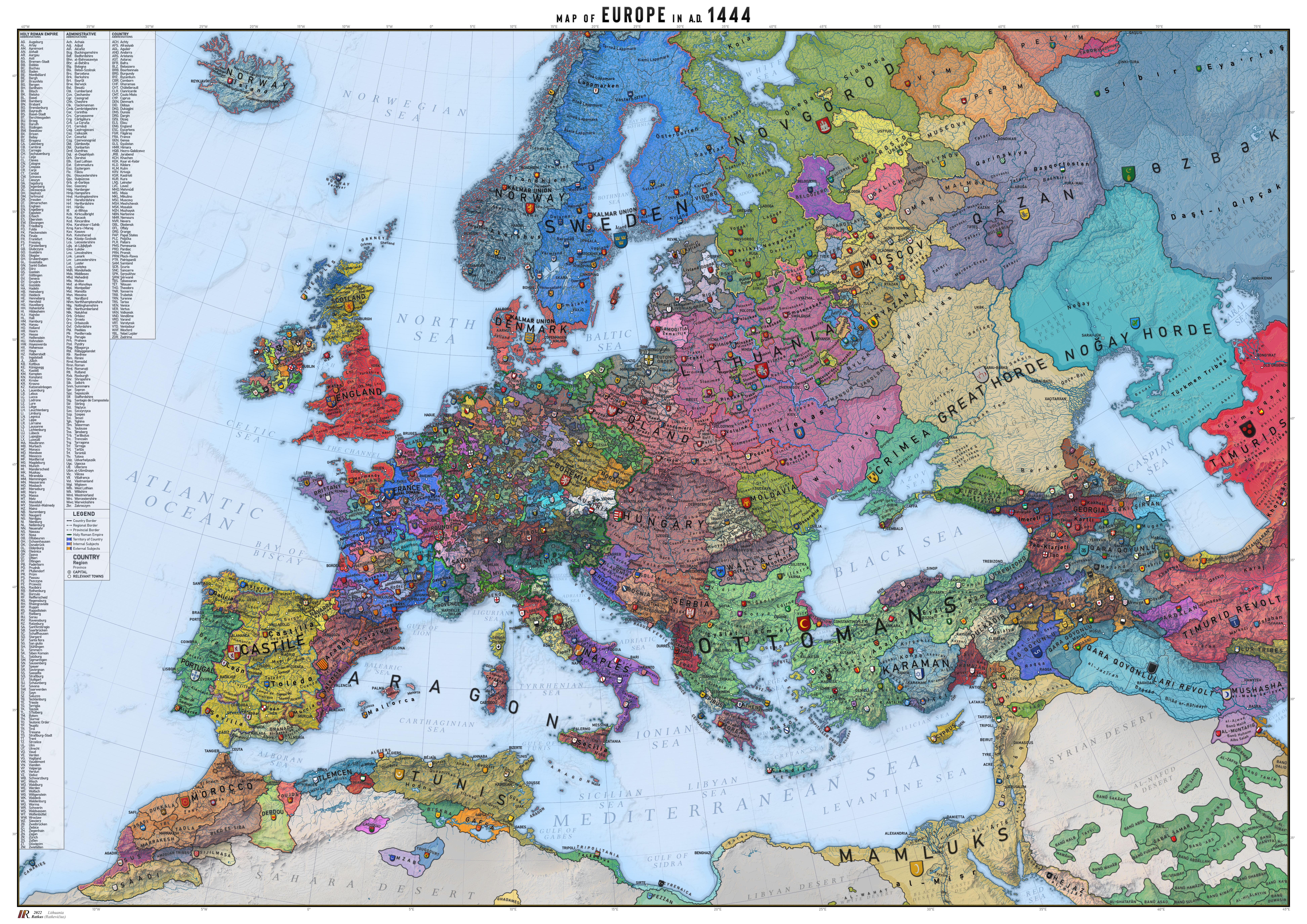
I dont know about the others but I see one mistake. Burgas wasn't connected to Constantinople. It was a Byzantine exclave seperated by Ottoman territoryA very detailed OTL map which gives a real impression of the political fragmentation and diversity of fifteenth century Europe. By ratkabatka on deviantart.
You are using an out of date browser. It may not display this or other websites correctly.
You should upgrade or use an alternative browser.
You should upgrade or use an alternative browser.
Map Thread XXI
- Thread starter fluttersky
- Start date
-
- Tags
- map map thread
- Status
- Not open for further replies.
Threadmarks
View all 131 threadmarks
Reader mode
Reader mode
Recent threadmarks
[50+ Likes] Sultanate of England, by Sārthākā Big Nations series, by Alex0505 A re-projection of Jean Lattre's 1762 world map, by Ashtagon [50+ Likes] The Russo-Ukrainian conflict in context, by NeonHydroxide Rose, Tulips, and Liberty, by Unkown00 Caliphate of Albion 1450, by Sārthākā 1932 Centauri-Human War, by Alex0505 Bharata is the World (part 3) by wildviper121Yeah, I couldn’t see the survival of this state if Japan was axis, so I’m guessing WW2 doesn’t involve Japan at all, and the USA still has to be allies with the USSRI assume Japan never joined the Axis ITTL?
A rough-and-ready map of the Roman Empire + the Alexandrian Empire. It just possessed me to make it.

Not my map, so I can't vouch for its accuracy.I dont know about the others but I see one mistake. Burgas wasn't connected to Constantinople. It was a Byzantine exclave seperated by Ottoman territory

In any case, it's an incredibly-detailed work... I might even use it as a point-of-reference myself *someday*, even if I have no intention of going all the way back to 1444Not my map, so I can't vouch for its accuracy.
This is funny to me as an early POD enjoyer and early medieval + antiquity nerd (no shade being thrown at late POD fans here dw). I see 1444 and I think “damn that’s kind of late” and ur like “I have no intention of going that far back”. I forget that that’s a pretty far back PODIn any case, it's an incredibly-detailed work... I might even use it as a point-of-reference myself *someday*, even if I have no intention of going all the way back to 1444
Well.... I might go back a bit further than that, but only with large butterfly nets with a very tight weaveThis is funny to me as an early POD enjoyer and early medieval + antiquity nerd (no shade being thrown at late POD fans here dw). I see 1444 and I think “damn that’s kind of late” and ur like “I have no intention of going that far back”. I forget that that’s a pretty far back POD
Early PODs: if you take the timeline to current day, you either have to take responsibility for writing a new history for pretty much everything on the planet, or you use a butterfly net. It's a tough choice.Well.... I might go back a bit further than that, but only with large butterfly nets with a very tight weave
1444's a bit early for me too. I prefer stuff a generation later when the English are out and the house of cards known as the Valois liminal principalities starts crumbling.This is funny to me as an early POD enjoyer and early medieval + antiquity nerd (no shade being thrown at late POD fans here dw). I see 1444 and I think “damn that’s kind of late” and ur like “I have no intention of going that far back”. I forget that that’s a pretty far back POD
True. I usually don't take it to the modern day when I start early though (I say this as I've been working on a TL for the past few years that ranges from about AD 300 to AD 1500ish which is basically writing a new history for pretty much everything on the planet lmao, and yes it's exactly as overwhelming and slow as it sounds but hey, I'll at least eventually post a few maps associated with it that I HAVE finished, but hey, 1500 is still not the modern day)Early PODs: if you take the timeline to current day, you either have to take responsibility for writing a new history for pretty much everything on the planet, or you use a butterfly net. It's a tough choice.
This is a map graphic we made for explaining the lead up to the Atlas Altera World Cup. It shows the qualification groups (by region) and berth allocations used by the IOFCAF.
View attachment 791708
Behind it, we've also provided a ranking table of the top 150 teams in the world, with 150 unique flags put together or created from scratch by the fellow travellers or syntopian poputchiks of Atlas Altera (feel free to tag yourself in this thread with the flags you helped make!).
View attachment 791709
Our first map for this series on the world cup was this one, featuring stadiums. We also made a time-based kick-off map and a transportation-themed map with a complete match schedule.
If you'd like to participate in a match predication challenge for the ATL version of the World Cup, we are going to be doing it on our Discord server. All are welcome to join and participate. You have the chance to get free project merch giveaways. You can also just follow match results on r/atlasaltera.
Cool map and ranking - kinda surprised to see Ligury above Lombardy and Tuscany in the ranking, but since that's where football first reached Italy, it makes sense - and an independent Liguria wouldn't see the disbandment or merger of most of its old teams, either; sure, Genoa-based teams would still dominate just due to the city's prominence, but there wouldn't be just two of them.
All things considered, the top of the ranking is quite familiar, aside from the German states being weaker overall.
Planet of Hats
Donor
The HRE is every bit the gong show I expected.A very detailed OTL map which gives a real impression of the political fragmentation and diversity of fifteenth century Europe. By ratkabatka on deviantart.
Also it says something that I appreciate the choice to transcribe Sous down in the Maghreb as "Sus." Perhaps there's an impostor among us after all....
Figured I would share this abomination. I had a dream last night where, for some reason, I was voting in a Japanese parliamentary election. One of the leading candidates wanted to get Japan to form a "Mega-Canada." The voter guide I was reading while standing in line included a map of her proposed idea for this "Mega-Canada." I drew it out real quick.

Just like, what the Hell is this? It's not even all of Canada! I mean, Ontario is split practically in half. AND it includes part of Ohio, West Virginia, and Maryland? Not to mention Pennsylvania and the rest of the Northeast. Plus, what in the world is going on in East Asia? I guess Japan got Manchuria, but what the Hell is that part of Siberia doing there?
I'm almost tempted to create a quick TL (not a serious one) that explains the history of this country, just as a brain-stretching exercise. I know this is completely implausible, but I'm curious what one would have to do to history to get it to produce such an abomination as above. What is my subconscious doing?
Wish I had stayed asleep longer. Apparently I was going to commit voter fraud and vote in an Italian election next, but I woke up before I could see the voter guide.
EDIT: You know what? Screw it. I'm gonna do it. I'm going to make a TL where for some God-forsaken reason, the above map is the outcome. Clearly the POD would be pre-1900, but I don't know if it would be best to put it there with a disclaimer that "This is not a serious TL" or if it would be best to put it in ASB, since I am trying to explicitly guide the TL to the end result of this map. Any thoughts?
Last edited:
Well to start, you're gonna need an alternate American Revolution to account for the Canadians holding onto Delaware. Maybe get the rebels to form a South-dominated expansionist republic which rolls west without regard for Native treaties or European borders, even buying Rupert's Land somehow. Then you'll have to get an alternate Opening of Japan, possibly resulting in the isles becoming a sort of British protectorate. After that, perhaps some kind of civil war happens that leaves one particular faction with the Crown's holdings in the New World and the Far East.EDIT: You know what? Screw it. I'm gonna do it. I'm going to make a TL where for some God-forsaken reason, the above map is the outcome. Clearly the POD would be pre-1900, but I don't know if it would be best to put it there with a disclaimer that "This is not a serious TL" or if it would be best to put it in ASB, since I am trying to explicitly guide the TL to the end result of this map. Any thoughts?
Great idea! I actually brainstormed about 7 scenarios (in brief) but didn't want to spam the thread about it. However, since a scenario has already been presented (and one which mostly aligns with one of mine), I figured I'd share my thoughts:Well to start, you're gonna need an alternate American Revolution to account for the Canadians holding onto Delaware. Maybe get the rebels to form a South-dominated expansionist republic which rolls west without regard for Native treaties or European borders, even buying Rupert's Land somehow. Then you'll have to get an alternate Opening of Japan, possibly resulting in the isles becoming a sort of British protectorate. After that, perhaps some kind of civil war happens that leaves one particular faction with the Crown's holdings in the New World and the Far East.
1. The Dutch colonize more of North America, leading to permanent settlements there. Then they open up trade with Japan and turn it into a part of their colonial empire.
2. The Portuguese land in North America initially rather than South America, establishing colonies there. They open up trade with Japan and turn it into a part of their colonial empire.
3. Somehow the Japanese discover the Americas first and manage to keep it secret from the rest of the world. They establish colonies in Central America then island-hop to that part of North America which they colonize.
4. Some other power (maybe the Norse via Vinland? Or someone else entirely?) discovers North America, colonizes that part, then moves on to colonize Japan (and other parts of East Asia).
5. The British decisively win the War of 1812, drawing part of the nascent US away into British North America. Somehow a civil war develops in British North America, leading the former US territories, Quebec, part of Ontario, and the Maritimes to break away from the rest of British North America. Somehow later, this new country forms a federation with an expanded Japan (or colonizes it), leading to this monstrosity.
6. Somehow the Americans win the War of 1812 very decisively, taking control of all British North American territory. A civil war breaks out in which the abolitionist North breaks away in, say, the 1830s or 40s. Then this breakaway nation establishes relations (either cordial or colonial) with Japan, leading to this abomination somewhere down the line.
7. Quebec and the Maritimes join the American Revolution while the South either doesn't or breaks away after a time. This different US then opens up relations with Japan, leading to map in question.
A very detailed OTL map which gives a real impression of the political fragmentation and diversity of fifteenth century Europe. By ratkabatka on deviantart.
Ah, their maps are excellent, but from what I recall much of their borders are derived from the Voltaire's Nightmare and Voltaire's New Nightmare mods for EU4. Any mistakes can be chalked up to that rather than their own original research.
Not necessarily, the author, also known as Orion, was involved in the Voltaire project maps, so any mistakes still come back to him.. However, having seen his work he does a LOT of background study before committing to map, if you are going to say "mistake" be very sure you are right.Ah, their maps are excellent, but from what I recall much of their borders are derived from the Voltaire's Nightmare and Voltaire's New Nightmare mods for EU4. Any mistakes can be chalked up to that rather than their own original research.
Did you vote for the Mega-Canada proposal?One of the leading candidates wanted to get Japan to form a "Mega-Canada."
I wish now, but I just voted for a bog-standard left-wing candidate.Did you vote for the Mega-Canada proposal?
Ratkabratka is not Orion thoNot necessarily, the author, also known as Orion, was involved in the Voltaire project maps, so any mistakes still come back to him.. However, having seen his work he does a LOT of background study before committing to map, if you are going to say "mistake" be very sure you are right.
Threadmarks
View all 131 threadmarks
Reader mode
Reader mode
Recent threadmarks
[50+ Likes] Sultanate of England, by Sārthākā Big Nations series, by Alex0505 A re-projection of Jean Lattre's 1762 world map, by Ashtagon [50+ Likes] The Russo-Ukrainian conflict in context, by NeonHydroxide Rose, Tulips, and Liberty, by Unkown00 Caliphate of Albion 1450, by Sārthākā 1932 Centauri-Human War, by Alex0505 Bharata is the World (part 3) by wildviper121- Status
- Not open for further replies.
Share: