The Treeguard still exists under the Kings of Rohan, Arnor has been repopulated, and the various nameless states of the Misty Mountains are Goblins or Orcs.Is Arnor more heavily populated here or is it still very low density, with only a couple human settlements? What are all the small colored things north of Rohan? A bunch of orcish tribes? And should we take it Gindir sealed up Fangorn and the Treegard of Orthanc?
You are using an out of date browser. It may not display this or other websites correctly.
You should upgrade or use an alternative browser.
You should upgrade or use an alternative browser.
Map Thread XXI
- Thread starter fluttersky
- Start date
-
- Tags
- map map thread
- Status
- Not open for further replies.
Threadmarks
View all 131 threadmarks
Reader mode
Reader mode
Recent threadmarks
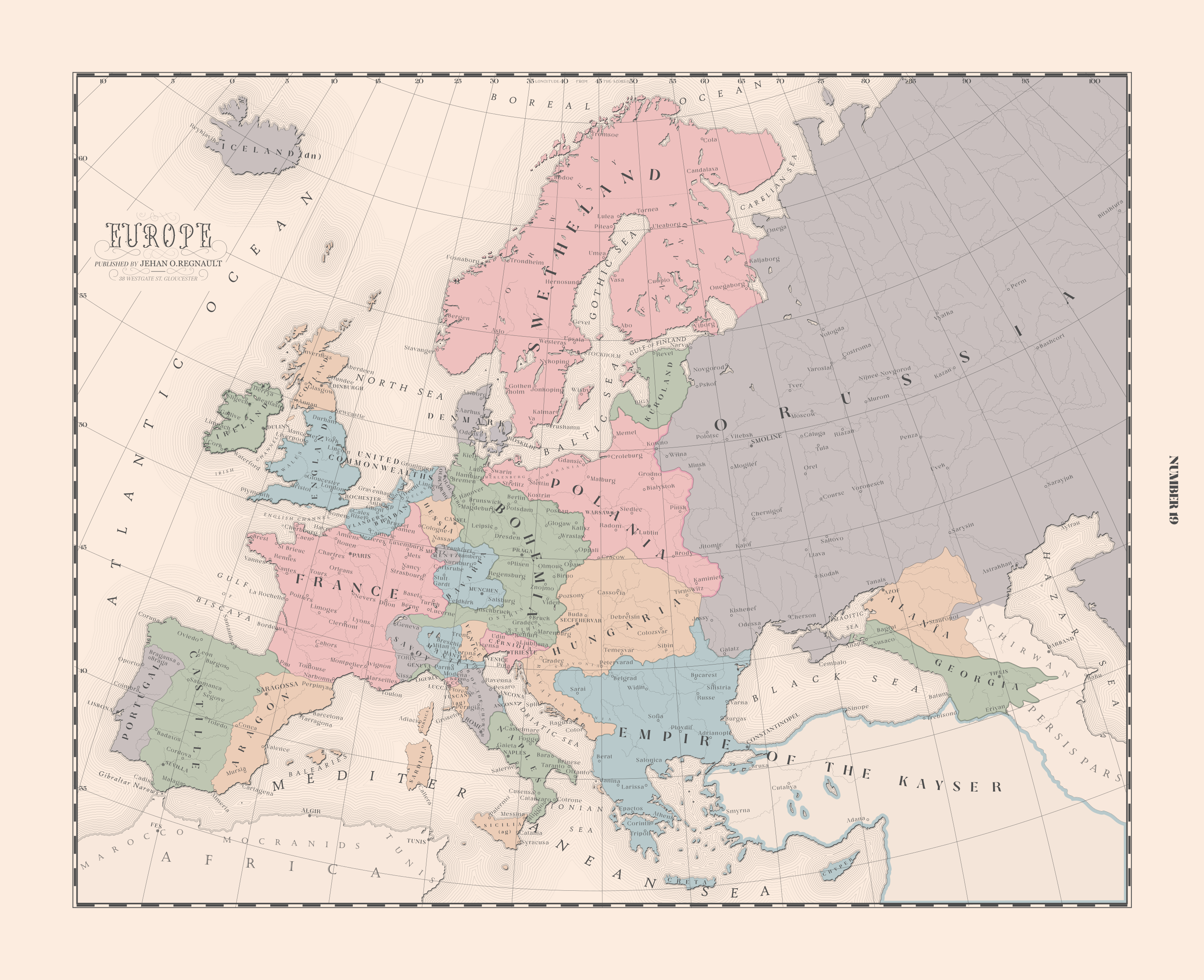
[50+ Likes] Sultanate of England, by Sārthākā Big Nations series, by Alex0505 A re-projection of Jean Lattre's 1762 world map, by Ashtagon [50+ Likes] The Russo-Ukrainian conflict in context, by NeonHydroxide Rose, Tulips, and Liberty, by Unkown00 Caliphate of Albion 1450, by Sārthākā 1932 Centauri-Human War, by Alex0505 Bharata is the World (part 3) by wildviper121The POD is in the early 13th century, and is essentially that the Habsburgs never extend their authority successfully over anything other than the eponymous Habsburg Castle. The POD was originally just to justify a one-off map I made of an independent Carniola, where I went back and tried to find the likeliest means to guarantee that. I put in enough work that the timeline's acquired a life of its own. By the present date, which is the 1860s, a lot of differences from OTL have started to mount up. One of the biggest ones is that, whilst some overseas possessions were taken, full blown colonialism as practised IOTL never fully becomes established, and so a lot of European states that IOTL are beefed up by their colonial possessions are not here. Another is that Bohemia retained its control over the HRE, but as a result of religious schism over Hussites, the HRE essentially split in the early 16th century. Lacking any kind of counterweight among the Catholic HRE states to Bohemia, they turned to France. So for some time, there's basically been a French HREmperor and a Bohemian HREmperor (which was itself a compromise to end really vicious religious wars), with this quasi-concensus breaking down early in the 19th century due to the emergence of radical political ideologies. The 'Orussian' state is actually a Mongol-Russian state. ITTL the Golden Horde converted to Orthodox Christianity rather than Islam, and whilst they still eventually collapsed, formed the basis for the Orussian state, with its capital at Smolensk, the spiritual heart of Mongolian Christianity, and whose King continues to claim Chinggisid heritage (and maintains a title of the Most Christian Khan). There's a lot of other Things that have mounted up over 600 years or so but that's a summary of a lot of the largest changes.Wow, really like it!
At least that aesthetic of the map.
Less sure about those borders, could you sum that timeline? What is it about and/or what its PoD?
One other piece of context is that these Bohemian borders, for instance, are relatively recent, only really being current from 1848-1866 (with the latter being the present date of the setting). There's been some regions nicked from nearby states as a result of the '48 war, and also a large number of previously autonomous Hussite HRE states who have been integrated into a centralised Empire, some more willingly than others.
So, I made some maps of a Green Sahara on the Robinson 2K-BAM.
Not every lake and river discovered to have existed in the Sahara is shown (besides, many of those are quite speculative still). It's just a selection of such bodies of water.
One with biomes, one without, which can be used as a patch for the map if anyone wants to make a map with a wetter/greener Sahara. I also tried to name the lakes within an imagined TL, the etymologies don't neatly match up with the names necessarily as most have evolved over time, like Ultahar is originally Walda Hari.
From Berber languages:
Tilelt - Little Sea
Ihzel - Swamp
Arazugh - Refuge (because of its isolated position, it's in a large drier stretch along trade routes between Egypt and Africa)
Ultahar - Womb of the Multitudes, All-Womb (heavily corrupted over time). Locals see it as a sort of origin point of life.
From ancient Egyptian:
Peyem - just a different spelling of an older form of Faiyoum. Means Sea, but originally may have just referred to this lake.
Akhet - Horizon, as it is at the very edge of the Egyptian world.
Other:
Ashi - Water (between Old Nubian and Proto Nubian)
Bukuru - Turtles, Turtle Lake (Proto-Niger-Congo)
So I saw a German map online just after the end of WW2, showing the newly created states. That was before the unification of Baden-Württemberg or erasure of the East German states. And that map gave me inspiration for this map in my own little (Big Weimar) "timeline".
Showing borders, states, their initials and names and their capitals.

Showing borders, states, their initials and names and their capitals.
What does that last bit in the legend say?So I saw a German map online just after the end of WW2, showing the newly created states. That was before the unification of Baden-Württemberg or erasure of the East German states. And that map gave me inspiration for this map in my own little (Big Weimar) "timeline".
Showing borders, states, their initials and names and their capitals.
View attachment 790694
"Seat of state government"What does that last bit in the legend say?
That's some very interesting lore, why not post it with the map right away?The POD is in the early 13th century, and is essentially that the Habsburgs never extend their authority successfully over anything other than the eponymous Habsburg Castle. The POD was originally just to justify a one-off map I made of an independent Carniola, where I went back and tried to find the likeliest means to guarantee that. I put in enough work that the timeline's acquired a life of its own. By the present date, which is the 1860s, a lot of differences from OTL have started to mount up. One of the biggest ones is that, whilst some overseas possessions were taken, full blown colonialism as practised IOTL never fully becomes established, and so a lot of European states that IOTL are beefed up by their colonial possessions are not here. Another is that Bohemia retained its control over the HRE, but as a result of religious schism over Hussites, the HRE essentially split in the early 16th century. Lacking any kind of counterweight among the Catholic HRE states to Bohemia, they turned to France. So for some time, there's basically been a French HREmperor and a Bohemian HREmperor (which was itself a compromise to end really vicious religious wars), with this quasi-concensus breaking down early in the 19th century due to the emergence of radical political ideologies. The 'Orussian' state is actually a Mongol-Russian state. ITTL the Golden Horde converted to Orthodox Christianity rather than Islam, and whilst they still eventually collapsed, formed the basis for the Orussian state, with its capital at Smolensk, the spiritual heart of Mongolian Christianity, and whose King continues to claim Chinggisid heritage (and maintains a title of the Most Christian Khan). There's a lot of other Things that have mounted up over 600 years or so but that's a summary of a lot of the largest changes.
One other piece of context is that these Bohemian borders, for instance, are relatively recent, only really being current from 1848-1866 (with the latter being the present date of the setting). There's been some regions nicked from nearby states as a result of the '48 war, and also a large number of previously autonomous Hussite HRE states who have been integrated into a centralised Empire, some more willingly than others.
I made an alternate religious world map:
.

Lore: This world diverged from ours when Ghenghis Khan declared himself the prophet of a new religion. While the religion was admittedly little more than a structured form of Turko-Mongolic Shamanism, It helped Mongols to assimilate their conquered populations instead of assimilating into them.
The following centuries saw various rebellions and massacres due to the clash between Islam and the new religion in West Asia. This saw a massive brain drain from the Middle East to Europe, India and Sahel. Out of the three regions, Sahelian Kingdoms were the only region not kicked in the groin by the Mongolian successor empires. As such it developed the fastest, discovered the Americas and started the age of colonialism.
Unlike our world Slavery and Scholasticism are still here. Although chattel slavery is all but eliminated due to innovations in mechanical technology and steam engine making it unneeded, civil servant slavery is still very common. Likewise, there does not exist a differentiation between church, state and education.
.
Lore: This world diverged from ours when Ghenghis Khan declared himself the prophet of a new religion. While the religion was admittedly little more than a structured form of Turko-Mongolic Shamanism, It helped Mongols to assimilate their conquered populations instead of assimilating into them.
The following centuries saw various rebellions and massacres due to the clash between Islam and the new religion in West Asia. This saw a massive brain drain from the Middle East to Europe, India and Sahel. Out of the three regions, Sahelian Kingdoms were the only region not kicked in the groin by the Mongolian successor empires. As such it developed the fastest, discovered the Americas and started the age of colonialism.
Unlike our world Slavery and Scholasticism are still here. Although chattel slavery is all but eliminated due to innovations in mechanical technology and steam engine making it unneeded, civil servant slavery is still very common. Likewise, there does not exist a differentiation between church, state and education.
Ok, the contest must go on so I have spent the night making something quickly and simply.
This world is based off of Man in the High Castle's "Heavy Lies the Grasshopper", but since ASB entries aren't allowed I tried to make it slightly more realistic by introducing an earlier root of American political discord. Essentially, WW2 came around on schedule, but A) the US was ready for Japan in the Pacific and B) the Soviets did not do nearly as well. British troops reinforced Stalingrad. Afterward, the US and UK fell into a Cold War, which the British eventually win after things get a bit too spicy.
I took advantage of the fact that I was on the clock to make a much simpler and more minimalistic map than I normally would, and to experiment with a different map template.
I may add more later or return to make this better another time. Right now I need sleep.
Because this is part of a timeline with its own thread rather than a one off, and I'd already posted a chunk of this when I shared other maps from the timeline here before. On the other hand that was quite a while ago now so maybe I should have posted it to start with, I'm just generally used to avoiding drilling lore into people's heads by repetition if I can avoid it and it's a hard habit to break.That's some very interesting lore, why not post it with the map right away?
So I saw a German map online just after the end of WW2, showing the newly created states. That was before the unification of Baden-Württemberg or erasure of the East German states. And that map gave me inspiration for this map in my own little (Big Weimar) "timeline".
Showing borders, states, their initials and names and their capitals.
View attachment 790694
Lovely map, nice art style. Props for saving Lubeck!
Interesting scenario. Obviously the Empire did not break up, what happened in India?Ok, the contest must go on so I have spent the night making something quickly and simply.
This world is based off of Man in the High Castle's "Heavy Lies the Grasshopper", but since ASB entries aren't allowed I tried to make it slightly more realistic by introducing an earlier root of American political discord. Essentially, WW2 came around on schedule, but A) the US was ready for Japan in the Pacific and B) the Soviets did not do nearly as well. British troops reinforced Stalingrad. Afterward, the US and UK fell into a Cold War, which the British eventually win after things get a bit too spicy.
I took advantage of the fact that I was on the clock to make a much simpler and more minimalistic map than I normally would, and to experiment with a different map template.
I may add more later or return to make this better another time. Right now I need sleep.View attachment 790767
BTW "The war saw the defeat of the first two.." the first two mentioned are UK & USA.

Pretty random, but here's a map I made last year showing the location of every Home Depot and Lowe's in Massachusetts. For the most part they tend to be located somewhat close to each other, but unlike Lowe's, Home Depot has a few locations in the really urbanized parts of metro Boston.
This is just a population density map of MassachusettsView attachment 790807
Pretty random, but here's a map I made last year showing the location of every Home Depot and Lowe's in Massachusetts. For the most part they tend to be located somewhat close to each other, but unlike Lowe's, Home Depot has a few locations in the really urbanized parts of metro Boston.
My take on if Napoleon won. He keeps naval superiority in the Mediterranean and Nelson dies earlier. Due to the Brits being in a worse position the US is able to take most of Canada. Portugal is chillin in exile in Brazil and was able tl fufil their pink map ambitions. The year of the map is 1895. Thoughts?
Attachments
Planet of Hats
Donor
Thicc Bohemia deserves notice.I actually started this map months ago but... life got in the way. This is accurate for Europe at the present date of They Come In All Colours (1866), although in-universe the map was made in 1862. I did consider adding some weathering and texturing to it but, in the end I don't think it would have added much beyond an inflated file size...
I suppose it's not too late to go, but if Qatar is not your jam, u/zeiner and I have made an Atlas Altera map featuring another tournament setting with plenty of exotic venues. I already posted our first two maps for this series last week in the map thread. They were on the stadiums/venues and kick-off times and group stage arrangements. This new map features major transportation routes for the part of the Mediterranean involved in the World Cup.

If you'd like to participate in a match predication challenge for the ATL version of the World Cup, we are going to be doing it on our Discord server.
All are welcome to join and participate. You have the chance to get free project merch giveaways. You can also just follow match results on r/atlasaltera.
I've also got the full match schedule for the event below. We've put up 96 unique flags on the infographic. These flags were put together or created from scratch by the fellow travellers or syntopian poputchiks of Atlas Altera.


Click here for the Reddit post, or click on the images for the Deviantart versions.
We call this the IOCAF Men's World Cup Meditera 2022 by the way...The lore here is that FIFA is replaced by the Society of Nations' own bureaucratic sports organization structure, leading to the tournament being held by the World Sports Council's International Organization for Football's Committee for Association Football—the WSC, IOF, and IOFCAF, respectively. Having countries share the right to hosting the tournament has become kind of a norm, but this year is the first time eight countries put together a successful bid to jointly host the tournament.If you'd like to participate in a match predication challenge for the ATL version of the World Cup, we are going to be doing it on our Discord server.
All are welcome to join and participate. You have the chance to get free project merch giveaways. You can also just follow match results on r/atlasaltera.
I've also got the full match schedule for the event below. We've put up 96 unique flags on the infographic. These flags were put together or created from scratch by the fellow travellers or syntopian poputchiks of Atlas Altera.
Last edited:
FireCrispyHistory
Banned
The only thing I have to say about this is one thing.My take on if Napoleon won. He keeps naval superiority in the Mediterranean and Nelson dies earlier. Due to the Brits being in a worse position the US is able to take most of Canada. Portugal is chillin in exile in Brazil and was able tl fufil their pink map ambitions. The year of the map is 1895. Thoughts?
Great map.
Threadmarks
View all 131 threadmarks
Reader mode
Reader mode
Recent threadmarks
[50+ Likes] Sultanate of England, by Sārthākā Big Nations series, by Alex0505 A re-projection of Jean Lattre's 1762 world map, by Ashtagon [50+ Likes] The Russo-Ukrainian conflict in context, by NeonHydroxide Rose, Tulips, and Liberty, by Unkown00 Caliphate of Albion 1450, by Sārthākā 1932 Centauri-Human War, by Alex0505 Bharata is the World (part 3) by wildviper121- Status
- Not open for further replies.
Share: