Map Thread XXI

Status
Not open for further replies.
Is there a reason why Niger remains part of the French state? Algeria's pretty obvious, but I'm not aware of anything special about French Niger.

I'm kinda surprised too. If it was North Mali and North Niger, it would be easy to explain as just more Sahara to extract resources from, but, well...
With an at the time small population, great resource potential (uranium in particular, but also gold, iron, coal, oil), sites suitable to make cement, the regime in Algiers thus thought that it could assert direct control over Niger. Mali comparatively had a higher population at the time (5.26 million vs 3.38 million) and they didn't want to cleave Azawad from Mali either...
 
A sequel to this post.
ACZPLaW.png
 
Nice scenario! I would like to see more of this world, especially of the Watchurian Empire. An egyptian successor state that conquers the Mediterranean sounds interesting.
I'm glad you liked the map! Watchur is probably going to be one of my next maps, for sure. Do mind that in TTL Egypt was conquered at the end of the Bronze Age by a nomadic Mesopotamian populace called the Karung; Watchur is the result of the fusion of Nubian culture with this substrate.
 
Jesus here is more accurately depicted (skin-tone wisi) than in a lot of art. (I think)
He really could have been anywhere between DJ Khaled to Bashar al-Assad. Westerners tend to have an obsession with categorizing regions of the world as made up of concrete, well defined racial blocks where everyone shares the same features and colouration, at least features and colours that we can contrast with our own. Much of the world is no where near this monolithic, certainly not the middle east and especially not the Levantine coast. I'd like to think that there is more to accepting and understanding Jesus as a middle eastern Jew then speculating about how brown he would have been compared to a white European, but it never ends up going anywhere except for that one single and purely physical metric.

I'm not sure if it's the result of aging, of artistic style, that Europeans may not have understood themselves as much in terms of 'whiteness' at the time when imagining themselves, or the materials, but allot of these older depictions of church figures tend to use these earthier and brassier colours, especially toward the East and in Orthodox iconography (certainly not to imply that Poland is Orthodox).
 
Last edited:
Gotta say that flag Jesus looks a lot like Ortho icons of the Mandylion -- mayhaps they could take the burning heart of the Cristeros?
 
The main map is now complete, now to spend 3 months doing the sub-maps
vM8ZL2Z.png
I must ask, is the blue on the flag here for Scotland or is it for France? I have seen some maps where they have a white cross with blue cantons representing France (I now suspect it is based off Quebec’s flag), and it does make an interesting Union Jack when four are combined. I see you have the Cross of Burgundy here instead of St. Patrick. Is it for the region of Burdungy in dark maroon, or does it symbolize Castile instead?
 
I must ask, is the blue on the flag here for Scotland or is it for France? I have seen some maps where they have a white cross with blue cantons representing France (I now suspect it is based off Quebec’s flag), and it does make an interesting Union Jack when four are combined. I see you have the Cross of Burgundy here instead of St. Patrick. Is it for the region of Burdungy in dark maroon, or does it symbolize Castile instead?
The blue is Multi-tasking and the Saw toothed cross is Castile [also known as the cross of St Andrew who OTL was patron saint of Spanish infantry]
 
Yo, long time since I've posted here. I made this.

I also wrote this explanation for this...thing, right here (warning, it's 296 pages, and I forgot Cameroon and the Maldives :():
https://docs.google.com/document/d/15Z7Y6-lOiD91tmAEWx6B7YcAU3YcVyubsVbv0J3iq-I/edit?usp=sharing

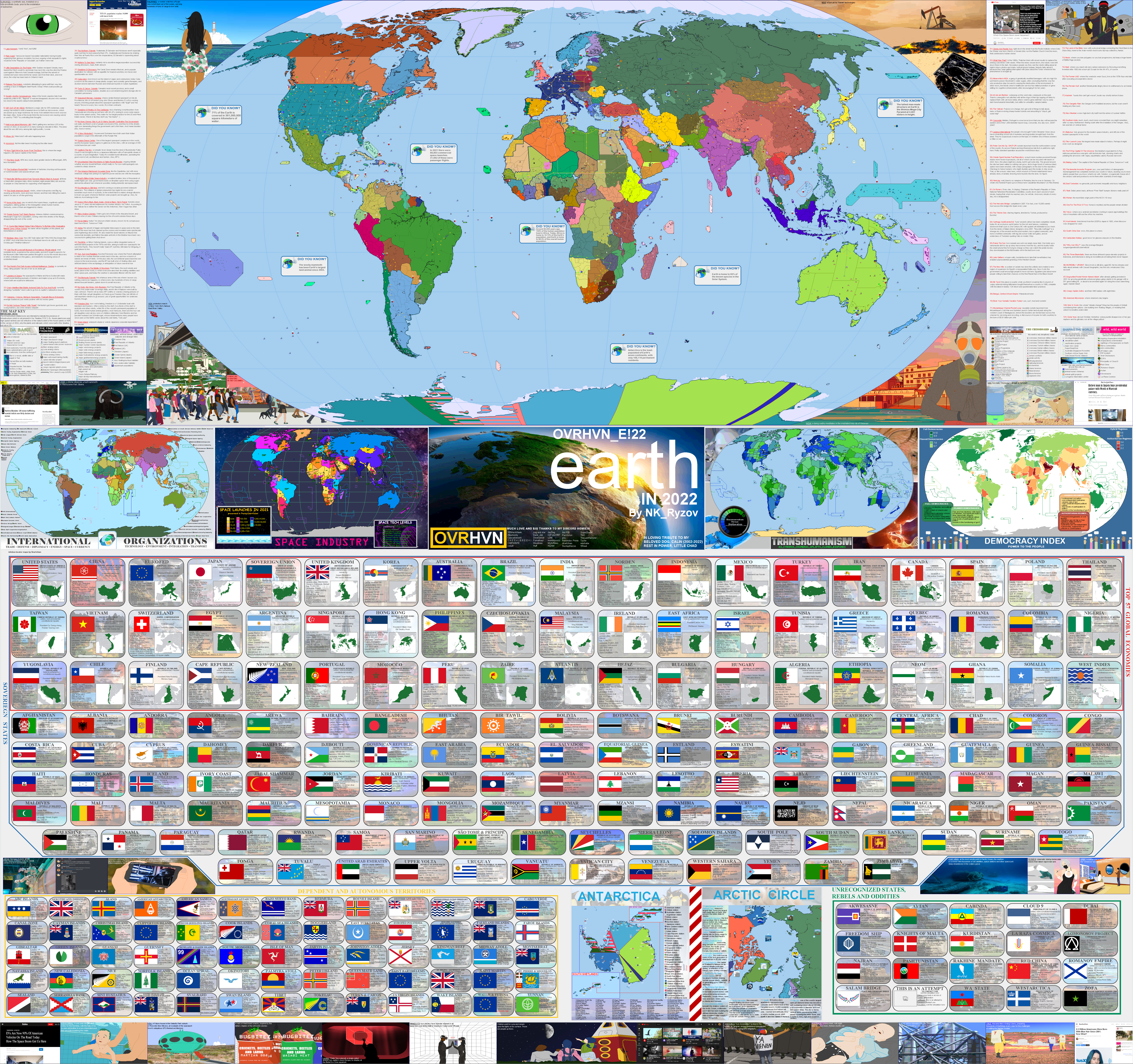
What is this? It's Earth. Third planet from the sun. In the futuristic year of 2022. 59 years after Nikita Khruschev's fateful decision not to include "space" in the list of places where you couldn't detonate nuclear weapons according to the Partial Test-Ban Treaty. This would lead to, among other things, a very different version of the Outer Space Treaty, a new arms race in the 1970s to put as many weapons in orbit as possible, a race to reach and colonize other planets, a man on Mars by 1976, a woman on Venus by 1978, a live-action film adaptation of Sailor Moon in 2000 starring Britney Spears, a prank call gone wrong leading to nuclear war between India and Pakistan, commercial nuclear fusion by 2011 and 10,000 people on Saturn's moon, Titan.

I hope it's cool if I share this here (the map and the doc), if not it's totally cool if this post is removed.


dfhorsj-8ae6cf76-953c-4b8b-b8af-72620d15e45c.png
whats with the xi jingping thing
 
I actually started this map months ago but... life got in the way. This is accurate for Europe at the present date of They Come In All Colours (1866), although in-universe the map was made in 1862. I did consider adding some weathering and texturing to it but, in the end I don't think it would have added much beyond an inflated file size...

dfidumo-1dbc9412-8ee6-4368-aedf-ece6e635c278.png
 
Map of the Great Lands of Middle-Earth in the year 1457 FA.
View attachment 790616

Shown are all the great and lesser Kingdoms of Men, the remaining Elves, and the Dwarves.
Is Arnor more heavily populated here or is it still very low density, with only a couple human settlements? What are all the small colored things north of Rohan? A bunch of orcish tribes? And should we take it Gindir sealed up Fangorn and the Treegard of Orthanc?
 
I actually started this map months ago but... life got in the way. This is accurate for Europe at the present date of They Come In All Colours (1866), although in-universe the map was made in 1862. I did consider adding some weathering and texturing to it but, in the end I don't think it would have added much beyond an inflated file size...

dfidumo-1dbc9412-8ee6-4368-aedf-ece6e635c278.png
Wow, really like it!
At least that aesthetic of the map.
Less sure about those borders, could you sum that timeline? What is it about and/or what its PoD?
 
Status
Not open for further replies.
Top