There's mention of native slaves from the mainland, and the fact that the Dutch had a settlement lost to the English.Not really. The books mostly focused on Atlantis. The rest of North America might as well not exist as far as the books are concerned.
You are using an out of date browser. It may not display this or other websites correctly.
You should upgrade or use an alternative browser.
You should upgrade or use an alternative browser.
Map Thread XIV
- Thread starter MorningDew
- Start date
- Status
- Not open for further replies.
Upvoteanthology
Donor
It talks about a "Dominion of Ontario" and a Dutch colony called Nieuw Haarlem, but that's about it.Did the books ever go into what was going on with the rest of OTL America north of Mexico? I mean, if you sail west from north Atlantis do you run into *Ontatio? *Michigan?
It talks about a "Dominion of Ontario" and a Dutch colony called Nieuw Haarlem, but that's about it.
More of Turtledove's paper-thin world building, alas. But it does leave one a lot of space for creating ones one, I suppose. Up to what year did he take the story, BTW?
More of Turtledove's paper-thin world building, alas. But it does leave one a lot of space for creating ones one, I suppose. Up to what year did he take the story, BTW?
1852
If I'd had more time, I wanted to make a bit of a map of Terranova, which is what the Americas sans Atlantis are called in this timeline. There's definitely a Dutch and English presence there, as stated. Other than that, expanding on what Turtledove laid out would be fun
Seems there's actually one later story: http://turtledove.wikia.com/wiki/The_Scarlet_Band
Edit: the cover, anyway, shows the west like this:

Last edited:
I began reading one of the books at the library once and later bought two of them after being outside of the US for some time and needing some good reading material to take back to Europe with me. Never got around to them. Though it might just be I had outgrown Turtledove or didn't start reading in the right order.Seems there's actually one later story: http://turtledove.wikia.com/wiki/The_Scarlet_Band
Edit: the cover, anyway, shows the west like this:
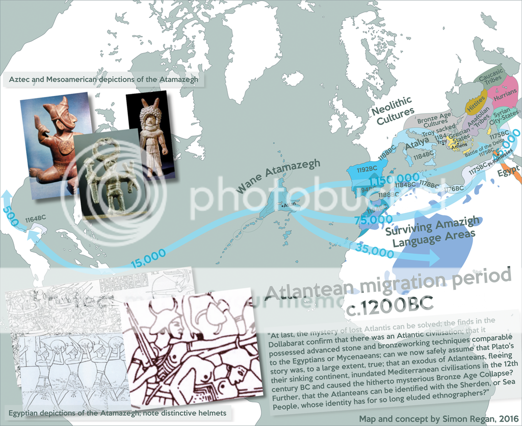
My take on the Atlantis challenge. It's somewhat pedestrian compared to the more creative interpretations of the challenge, but hopefully it combines enough plausibility with sufficient Ancient Aliens-ish connections to be interesting. As with my last MotF entry I ran out of time to do all the extras I wanted, such as a box-out of *Atlantis with the individual confederate kingdoms and cities depicted.
---
Many great and wonderful deeds are recorded of your state in our histories. But one of them exceeds all the rest in greatness and valour. For these histories tell of a mighty power which unprovoked made an expedition against the whole of Europe and Asia, and to which your city put an end.
This power came forth out of the Atlantic Ocean, for in those days the Atlantic was navigable; and there was an island situated in front of the straits which are by you called the Pillars of Heracles; the island was larger than Libya and Asia put together, and was the way to other islands, and from these you might pass to the whole of the opposite continent which surrounded the true ocean; for this sea which is within the Straits of Heracles is only a harbor, having a narrow entrance, but that other is a real sea, and the surrounding land may be most truly called a boundless continent.
Now in this island of Atlantis there was a great and wonderful empire which had rule over the whole island and several others, and over parts of the continent, and, furthermore, the men of Atlantis had subjected the parts of Libya within the columns of Heracles as far as Egypt, and of Europe as far as Tyrrhenia. This vast power, gathered into one, endeavored to subdue at a blow our country and yours and the whole of the region within the straits; and then, Solon, your country shone forth, in the excellence of her virtue and strength, among all mankind.
She was pre-eminent in courage and military skill, and was the leader of the Hellenes. And when the rest fell off from her, being compelled to stand alone, after having undergone the very extremity of danger, she defeated and triumphed over the invaders, and preserved from slavery those who were not yet subjugated, and generously liberated all the rest of us who dwell within the pillars.
But afterwards there occurred violent earthquakes and floods; and in a single day and night of misfortune all your warlike men in a body sank into the earth, and the island of Atlantis in like manner disappeared in the depths of the sea. For which reason the sea in those parts is impassable and impenetrable, because there is a shoal of mud in the way; and this was caused by the subsidence of the island.
Plato, Timaeus and Critias
One of the things that struck me reading Plato's description is that the chief feature of it is not the island but World War 0.5; the attempted conquest of the entire known world by a mysterious sea power. That connected in my mind to the Bronze Age Collapse and the enigmatic Sea Peoples (I later learned conspiracists have made the same connection) and set about creating an atlas (heh) type map depicting the furthest extent of Atlantean control, prior to being pushed back by Hellenic and Egyptian forces.
In my imagining, the invasion (or rather, mass settlement with military force) happens because Atlantis is sinking; the waves of migration and conquest destablise the delicate web of trade in the Mediterranean in the 18th and 19th centuries BC, leading to the Collapse. The Atlanteans are recorded in Egyptian records as the Sherden (literally means 'sea people' - in reality identified with, variously, Anatolians, Syrians, Philistines, Sardinians, or Etruscans).
Atlantis here was gradually flooded over a period of around 300 years (from 1465BC), with a final sequence of devasting earthquakes from 1175 to 1165 finally sinking the island, together with the remaining infrastructure supporting the invasion. Around 1.3 million Atlanteans were left in the Mediterranean and were gradually integrated (with a lot of bad feeling) into the societies they had tried to conquer, leaving behind lots of loan-words (the derivation of which is listed by our linguists today as 'unknown') and flood myths.
I was then left with the difficulty of identifying the Atlanteans with a present-day civilisation; after umming and ahing about Semites I opted to go with the Berbers, in whose language 'Atla' means 'mountain' (supplying an interesting suggestion for the derivation of 'Italia'), and who would be the obvious candidates to have settled Atlantis in the first place, around 3000BC. A slight anachronism - 'Amazigh' (which I have tweaked into 'Atamazegh' to furnish a fictional root for both 'Atlantis' and 'Amazon') derives from 'i-Mazigh-en', or 'freemen', and wasn't employed until long after this time period.
The Atlanteans used weapons of arsenical bronze; their signature weapon was a wide, triangular-shaped thrusting sword called the farissa (which became the Berber Flyssa). They were noted for their characteristic helms, which bore two horns; officers having a solar disk of polished bronze between the horns. Their religion initially centred on the worship of a female embodiment of nature, however, her sun-god consort Wanaka gradually became more prominent until he became the primary deity of Atlantean civilisation. Wanaka eventually became Poseidon, whose name in Greek derives from 'Earth-shaker' ('Enosichthon'); his cult in Greece arose as a movement of 'penitent' Atlanteans and was quickly adopted by jubilant Hellenes.
A few Atlanteans made their way to the 'whole of the opposite continent that surrounded the true ocean', enslaving the Mexica, who knew them as the Azteca Chicomoztoca. The stories of the Azteca Chicomoztoca's origins gradually became transferred to their slave people, who, after gradually absorbing their masters, vaguely remembered a homeland called Aztlan.
The last substantial descendent population of Atlantis was the Guanches of the Canary Islands, albeit they are descendents of a group who attempted to return to Atlantis 200 years after the Fall. Guatimac is the last surviving idol of Wanaka; the broadly T or cross-shaped shape of Wanaka's idols influenced Adyghe's Tha which became the Norse Thor.
The Atlantean homelands were below sea level until around the first century BC, when an earthquake raised the Azores (which were Atlantis's mountain tops) above sea level. Joshua Vander Berg's (IOTL almost certainly hallucinated or fabricated) horse statue, which still exists but is overgrown, was the last seen relic of Atlantean civilisation.
-
Full size version
Last edited:
Gian
Banned
So here's a map that I made (in Paint) showing the anglophone/francophone communities in the Maritimes in phil03's The Bullet of Providence (please check it out)

hey you guys...today i've seen the...well..18th or so "trump is literally hitler and the world is gonna go 1984 on steroids soon"-map. it's getting silly. is this a "stronger together"-campaign board, or what? i loved alt-history map thread for it's intellectually sound approach..maps are confined in a construct of historical analysis, the broad knowledge of the board, impartial judgement, short: adults making good stuff.
could you tone down the shriek propaganda`? thanks!
(a humble lurker and loyal reader since ages).
could you tone down the shriek propaganda`? thanks!
(a humble lurker and loyal reader since ages).
I made this map a while ago, just to visualize how the word "India" had spread from referring to one river to being the name of several countries and states. Then I figured I would take it to the next level, and include anywhere that was historically related in any way to India. Then, I made a (very ASB) scenario to see how a "country" like this could come about. Enjoy!
~~~~~~~~~~~~~~~~~~~~~~~~~~~~~~~~~~~~~~~~~
POD: Muhammad Iqbal died at age 17 from appendicitis, so he was never able to propagate his idea of an independent Muslim state on the Indian subcontinent.
Muhammad Ali Jinnah is widely considered a key member to the founding of the All Indian Union, second only to Mahatma Gandhi himself. Jinnah joined the Indian National Congress in 1904, and quickly became known for his support of Hindu-Muslim unity. Following the division of Bengal, Jinnah traveled to England to personally argue for its reunification before parliament. Jinnah also argued that several colonies that had been part of the British Raj should be reunified with the Raj in order to promote trade and economic growth. While on this point he was less successful, British Somaliland was reincorporated into the Raj, and plans to split off Aden and Burma from the Raj were also dropped. He briefly left politics during the 1920s because of ideological differences from the majority of the Indian National Congress, but returned in the 1930s to present his 14 Points of Unity. Jinnah’s rhetoric was key in maintaining Muslim faith in a unified India, and Jinnah worked with Gandhi to rally the popular support of Muslims during the nonviolent protests against British Rule.
British rule ended May 1, 1946. The newly independent All Indian Union faced low level religious and ethnic violence in the first few years, but this died down. The Union quickly became involved in foreign affairs, joining the United Nations, and providing support for the Indonesian rebels and for Tibet, which was fighting against communist China. Tibet was able to maintain independence with Indian help, but Indonesia proved to be more of a thorn. India was one of the first countries to recognize Indonesia’s independence, and Nehru, who was fond of Indonesian culture, sent an expeditionary force to Indonesia to help in the fight. Nehru also personally talked with Sukarno, the president of Indonesia, and the two of them bonded over their support of socialist policies. As the Indonesian Anti-colonial War dragged on, the two nations grew closer. Sukarno and Nehru secretly negotiated a pact in which India would send troops to help in the fight, and in return Indonesia would unify with India after the war. The reasoning behind this unorthodox negotiation was that Indonesia desperately needed help, and Nehru hoped that by almost doubling the population of Muslims in India, he could prevent Indian Muslims from rebelling. The Pact was signed June 10, 1948, and the dutch soon recognized the loss of Indonesia.
At the same time, the Communist Party of China had all but won the Chinese civil war, but Tibet was still occupied by India. India planned on removing their troops, but the Dalai Lama instead requested to be annexed by India, for their own protection. India obliged, which greatly hurt relations between India and China. China and India did not extend diplomatic recognition to each other until 1976. Nepal, Sikkim, and Bhutan were surrounded by India, and entered into a customs union that allowed for free travel across their borders into India and removed all trade barriers. All three countries joined India after the Great Recession of 1994.
Throughout the 1950s, the massive All Indian Union worked on promoting their ideals of pacifism and neutrality. While the nation did not expand its borders during this decade, economic trade grew with nations around the world, especially in eastern Africa. The Non Aligned movement was founded in 1959, with the three founding nations being India, Yugoslavia, and Egypt. As European colonies gained independence, many joined the Non Aligned Movement.
In 1960 France withdrew from NATO, following disputes with the USA and UK over sovereignty and what France perceived as USA-UK conspiring. This shocked the world, and led to the split of NATO entirely. The USA, UK, Iceland, Holland, Turkey, Norway, Denmark, and West Germany remained as NATO. France, Italy, Greece, Portugal, Belgium, and Luxembourg created the European Mutual Defense Organization, or EMDO.
The whole world was shocked by this, but in the USA it caused a firestorm. Losing half of NATO caused president Stevenson to resign, and Michael DiSalle became President of the USA. Even before the dissolution of NATO, desegregation had been tearing the USA apart, but now the Federal government had been humiliated as it never had before. Many pro-segregation southern state governments now openly defied orders to desegregate school, buses, and other state run enterprises, and used their State Troopers to re-enforce segregation. DiSalle, while charismatic, was inexperienced, and floundered with how to deal with what was later named The American Power Struggle. However, the decision was soon taken out of his hands as the southern States declared that they would no longer take orders from Washington that they did not agree with. Federal forts were surrounded by State Troopers and forced to evacuate the south. Delegations from every southern state met in Richmond, and discussed how to defend their newfound autonomy. DiSalle threatened to deploy the army in order to enforce the Federal Government, but was to hesitant to follow through. He did not want any bloodshed, and tried to negotiate his was out of the crisis. By being so indecisive, DiSalle had granted the South de facto independence without a fight. In the south, August 12 1961 is still celebrated as the Day of Independence.
The rest of the country was outraged, and DiSalle was impeached in early 1962. Dean Rusk became president, but by that time it was too late to easily force the South to rejoin. Months of inaction had discredited the federal government in the eyes of every american, and the south had used these months to prepare for any interference from the north. Coupled with the fact that the armed forced had been decimated by southerners defecting and returning home, there seemed to be no easy solution. At the same time, around the world countries were turning to the USSR and India while the USA unwound. The federal government could not reunite the south, and throughout the 1960s more and more states began to ignore the federal government, and the federal government began to do less and less. The USA evacuated their forces from Vietnam in 1967. It was the last war America was involved in.
While the USA was collapsing, India was expanding. In 1963 the Malaysian Federation was created as a union of the Malaya Federation and the former British Colonies of Sarawak, Brunei, and North Borneo. The people of the Malaysia were ethnically similar to the people of the East Indies and spoke almost the same language. The East Indians wanted Malaysia to be part of India, but Malaysia wanted to stay independent. This led to the Konfrontasi (Indonesian for Confrontation), also known as the Indian-Malaysian War. India invaded Malaysia with the expressed interest of conquering it. While this was deplored by the International community, no country was willing to help Malaysia out of fear of provoking India. The USSR felt that controlling Indochina was enough influence in Southeast Asia, and did not feel compelled to do more than complain to the United Nations. Malaysia fought bravely, but is was almost surrounded by India before the war started, and had a weak military. Malaysia was conquered in 1964, and did not become an Indian state until 1984. East Timor was bought from Portugal by India in 1970.
In 1965 the West Indies Federation voted to join the All Indian Union. Both the USA and UK appeared to be growing weaker by the day, and they needed someone to support them. There was also a large population of Indian descent on the islands, especially after Guyana joined the federation in 1963.
On September 4, 1978 the United States of America was officially dissolved. By that point only the Mid Atlantic States participated in the federal government, and the Cold War had shifted from USA vs USSR to USSR vs India and EMDO. The Southern States created the Confederation of American States, the west formed the Pacific State of America, and in the Midwest and East most states simply went their own ways as independent countries, at least in the beginning. In the Midwest, many nations struggled economically, and looked for something to support them. Most states turned to Canada, but in the Republic of Indiana, President Robert Orr tried a more international approach. At first he tried bringing his country closer to Brazil, but after the Brazilian Civil War broke out, he was back on the market. Jokingly, he said at a press conference that he would talk with the All Indian Union to see if having “India” in your country’s name was enough reason to join the Union.
However, a week later he got a call from Charan Singh, the Prime Minister of India. Singh was hoping to create an alliance/trade deal with one or more Midwestern nations in order to have a country to provide the West Indies food, among other things. In return India would provide military defense for Indiana, should Indiana need it, along with some other perks. Indiana accepted.
Throughout the 1980s and into the 1990s Indiana grew closer and closer to India economically. However, following the worldwide recession of 1994, Indiana’s economy was devastated. Indiana declared found itself unable to pay its debts in 1996, and needed a bailout. The only country willing to bail out a small agricultural nation was India, but India would only bail Indiana out if Indiana joined the All Indian Union. India wanted Indiana in the Union in order to ensure Indiana would continue to provide food for the West Indies, and as a base to expand Indian influence in North America. Joining India was controversial in Indiana, and a referendum was help in 1997. 53% of the population voted to join India, and Indiana officially became a state in the All Indian Union on January 1, 1998.
Today, the All Indian Union is the most populous nation on Earth, with over two billion inhabitants, more than a quarter of the world’s population. It is the world’s largest democracy, with Japan in a very distant second place. It holds a permanent seat on the United Nations Security Council, along with the USSR, the UK, the PRC, and France. India is a federation of 40 states. The country is unofficially divided into five “culture zones”:India Proper (Indian Subcontinent), East India (Indonesia), Yemen and Somaliland, West India (Caribbean Islands), and American India (Indiana). The inhabitants of these regions are called Indians, East Indians, Arabs and Somalis, West Indians, and Hoosiers; respectively. While thoughts of succession are voiced in all of these regions, Yemen and Somaliland especially, the rapidly growing economy has kept these thoughts quiet.
How is it that this is not part of Quebec?So here's a map that I made (in Paint) showing the anglophone/francophone communities in the Maritimes in phil03's The Bullet of Providence (please check it out)
Seraphiel
Banned
What the deuce has happened to Colombia down to Chile?
As a particularly shitty El Nino screwed over Peru a minor border incident in the mid 21st century escalated, resulting in a South American world war of sorts wherein Chile, Argentina, Peru and Colombia were the losers.
X-posting my MotF entry. The idea is that Doggerland isn't completely submerged at the end of the last ice age, but instead remains as a landbridge between Britain and Europe, inhabited by Germanic-speaking peoples.

The 10th December 1895 would go down in history as one of the most destructive days in the history of not only Silverland, but of Europe as a whole.
At 23:26 on the evening of 9th December, seismologists working from a lab in Bergheim, Norland detected an unexpected tremor originating 50 miles off the coast in the north German Sea. Another jump in activity followed 23 minutes later. A few hours later, monitoring stations further down the Norlandic coast and across the sea in Pictland reported a drop in the local sea level. Trawlers working out in the sea also radioed in descriptions of a great swell moving southwards towards Silverland. Then, at 04:58 it struck. A massive wall of water hit the northern coast of Frysland island, inundating crops, woodland and turning houses into rafts of floating debris in a matter of minutes. Water rushed up the Natal River, reaching the provincial capital Klausburg at 05:04. The greatwave had now crossed the Silver Sea and reached the mainland, bringing with it continued devastation as town after town, city after city along the coast was hit by the sea's power.
Much of the coastal provinces of Meerland, Zilvedal and Vestvolke were flooded, with the water reaching inland to Hougland and Batava, leaving only Rynmark in the far south untouched. The greatest impact though was on Oesteland, with over two-thirds of the province underwater. The capital city Danstad saw all but its highest rooftops submerged, with the city's historic heart completely destroyed.
The international response to the disaster, by far the largest in peacetime Europe, was unprecedented with donations following in from around the world. People in countries with historic ties to Silverland such as Christsland, Southland and New Meerland were particularly generous as many still had relatives in the "Old Country". Military personnel from neighbouring Sachsland, Lutecky and Belgary were deployed to help with the cleanup operation while Romanian, Espanic and Turcian schoolchildren filled shoeboxes for their Silverian counterparts, many of whom had been orphaned by the wave.
It is estimated that of a pre-Greatwave population of 32 million, 2 million lost their lives on the day of the disaster, while a further 8 million were displaced. The economic damage has been estimated at Fl. 7 billion. The damage wrought by the wave was so great that some land was permanently lost to the sea while others were rendered unusable due to pollution and salt poisoning for many decades afterwards.
Gian
Banned
How is it that this is not part of Quebec?
I'll just happily suggest that you go and read phil's TL (because it has information regarding it, particularly the post on the alt-American Revolution)
re: Bullet #17Ugh. Im so tired that I will write a bigger back-story later.
Basically its my take on making a future-history scenario. The year is 2025, the EU got dissolved, Putin went crazy with bullying Russia's neighbours, Trump allied Moscow and nationalist France. The world is heading for another war.
I hope you like it.

Japs?
Did you just port in from 1943?
Don't do that.
Trump gives massive platform to an ideology that poses an existential threat to you if you are Muslim, Black, LGBTQ, a woman seeking an abortion, or an immigrant (legal or illegal). As such, if you fall into one of these categories or if someone you love falls into one of these categories, there is great reason to be scared. Many of the people making 'Trumpocalypse' maps are doing so to vent that fear in a creative direction which, IMHO, is something that ought to be encouraged and respected.hey you guys...today i've seen the...well..18th or so "trump is literally hitler and the world is gonna go 1984 on steroids soon"-map. it's getting silly. is this a "stronger together"-campaign board, or what? i loved alt-history map thread for it's intellectually sound approach..maps are confined in a construct of historical analysis, the broad knowledge of the board, impartial judgement, short: adults making good stuff.
could you tone down the shriek propaganda`? thanks!
(a humble lurker and loyal reader since ages).
Folks post maps here to share their work and get feedback for a variety of purposes. Maybe they want to improve their mapmaking skills by talking to some of the skilled cartographers that frequent the board. Maybe they wanted to post a silly idea and see if it would get a laugh. Maybe they wanted to share a map from their timeline that they're proud of because they finally created a good alternative to That Damned Kazakh Border. Maybe they're scared for the future and want to express that fear artistically.
You have every right to respond to an individual Trumpocalypse map and explain why it doesn't make sense to you or why you think it's a bit much. But to criticize the style in the way you did largely amounts to 'Hey guys, I'm really tired of seeing how scared you are. Can you stop feeling that way so that I can consume the content produced here in a manner more comfortable for me?' which is, I hate to tell you, not the point of this thread. The point is to post maps.
Dementor
Banned
This is not Latvia, but Lithuania (called Litva in Czech).Love to understand the butterflies that made Kaliningrad divided between Poland and Latvia and why Ukraine has some of the OTL Romanian Black Sea coast!
I have yet to see Trump create this "Fourth Reich" and I take such claims with a hint of salt; sorry to get political here but I'm with schubert on being annoyed by the "Trumpocalypse" trend.Trump gives massive platform to an ideology that poses an existential threat...etc, etc, etc.
So yeah, less Trumpocalypse and more something else, like a WWI that starts later or earlier or oh I don't know, a very British civil war or something.
I personally vote for the next major trend to be maps with POD's around 50,000BC or earlier, but that's probably just wishful thinking.I have yet to see Trump create this "Fourth Reich" and I take such claims with a hint of salt; sorry to get political here but I'm with schubert on being annoyed by the "Trumpocalypse" trend.
So yeah, less Trumpocalypse and more something else, like a WWI that starts later or earlier or oh I don't know, a very British civil war or something.
- Status
- Not open for further replies.
Share: