Alex Richards
Donor
An asb map I made while bored during a long car ride.
I present a worldwide British Raj:
Not enough complex borders or splitting things up into odd Princely States.
An asb map I made while bored during a long car ride.
I present a worldwide British Raj:

With OTL state borders superimposed
The American Revolutionary War (1775-1785) had a profound effect not only on the country itself, but on the various borders of the states. The protracted occupation of the City of New York forced the political reorganization of the former Province of New York in light of the increasing legitimacy and permanence of the American political structure. Following several repulsed offensives into the Lower Hudson Valley, Congress - following a failed militia coup against the state government, now meeting in Albany - allowed the avowedly patriot states of New Jersey and Connecticut to organize the governments on the east and west banks of the Hudson River, respectively. The State of New York's government, reestablished in Albany primarily by militiamen from the New Hampshire Grants, was outmaneuvered in the continental Congress and did not recognize these claims until after the war. Following the end of the war and the assumption of New York's debts, the State reorganized itself as the State of Montagne, so named for the Green Mountains in the east, Catskill Mountains in the south, and the Adirondack Mountains in the north. The City of New York itself became a Federal district and the seat of the Congress of the Confederation, so it proved to be the natural site for the permanent capital city of the country. With the passage of the Northwest Ordinance and an increasing Federal interest in resolving land claims, the western claim of Montagne (which had legally succeeded New York) and Massachusetts was resolved with the creation of the Erie Territory, which later became the State of Erie.
The Hudson River, south of the Montagne border, is considered Federal property and not part of either New Jersey or Connecticut. Regardless, New York, D.C. and the three other states began to grow exponentially with the construction of the Oneida Canal in the 1810s-1820s[1]. New York soon became one of the world's largest ports, and the "American London" - the cultural, political, and financial center of the country - began to leave a suburban imprint on the neighboring states, as well.
[1] I figure the Oneida canal shoots up from the Mohawk River to Oneida Lake and then out through the Oneida River into Lake Ontario. A multi-state construction project of the Erie Canal would be a little too politically hard to pull off in the period.
An asb map I made while bored during a long car ride.
I present a worldwide British Raj:View attachment 285435
The first two could easily be alt-Communisms.Could be Communal Russia, Computerized Russia, Cometary Russia, or Comical Russia.
Well done (as well done as a map like this can be) but why is the Jewish Autonomous Oblast a protectorate while Palestine isn't?
...Is this a question I should be asking, considering the content?
Not enough complex borders or splitting things up into odd Princely States.
Hmm... Too big for China to be governed as a single entity, her regional differences are no smaller than that in India you see, she should be chopped into half South-North at best, or divided as bunch of autonomous states according linguistic lines, the orgasm produced from this map would be more effective if you can pull that off.
With OTL state borders superimposed
The American Revolutionary War (1775-1785) had a profound effect not only on the country itself, but on the various borders of the states. The protracted occupation of the City of New York forced the political reorganization of the former Province of New York in light of the increasing legitimacy and permanence of the American political structure. Following several repulsed offensives into the Lower Hudson Valley, Congress - following a failed militia coup against the state government, now meeting in Albany - allowed the avowedly patriot states of New Jersey and Connecticut to organize the governments on the east and west banks of the Hudson River, respectively. The State of New York's government, reestablished in Albany primarily by militiamen from the New Hampshire Grants, was outmaneuvered in the continental Congress and did not recognize these claims until after the war. Following the end of the war and the assumption of New York's debts, the State reorganized itself as the State of Montagne, so named for the Green Mountains in the east, Catskill Mountains in the south, and the Adirondack Mountains in the north. The City of New York itself became a Federal district and the seat of the Congress of the Confederation, so it proved to be the natural site for the permanent capital city of the country. With the passage of the Northwest Ordinance and an increasing Federal interest in resolving land claims, the western claim of Montagne (which had legally succeeded New York) and Massachusetts was resolved with the creation of the Erie Territory, which later became the State of Erie.
The Hudson River, south of the Montagne border, is considered Federal property and not part of either New Jersey or Connecticut. Regardless, New York, D.C. and the three other states began to grow exponentially with the construction of the Oneida Canal in the 1810s-1820s[1]. New York soon became one of the world's largest ports, and the "American London" - the cultural, political, and financial center of the country - began to leave a suburban imprint on the neighboring states, as well.
[1] I figure the Oneida canal shoots up from the Mohawk River to Oneida Lake and then out through the Oneida River into Lake Ontario. A multi-state construction project of the Erie Canal would be a little too politically hard to pull off in the period.
Just another addition to the Kingdom of Normandy one – The Duchy of Calais
The Duchy of Calais came under control of the Kingdom of England following the decline of the French Crown. With England coming into control over southern France through inheritance a few years shy of 1200 France found itself slowly being pulled apart. Normandy had gone in 1066 and now a large section of southern France. This was more of a problem for the French King as the Nobles found themselves in a better situation, being more able to take advantage of the situation to strengthen themselves rather than the realm. In 1220 The French King Louis VIII attempted to regain its lost land, launching an attack into Normandy. In short the war with Normandy and England on one side and the French on the other ended badly for the French. They were forced to give up more land to the Norman’s who wanted to secure their control over the Loire River and the English would eventually gain control over the area which became the Duchy of Calais following the treaty of Boulogne
The region became heavily important to the English economy being a hub for trade with the continent. Over the years English and Flemish became the main languages of the area as French was phased out slowly, with only the southern nobles using the tongue. The cities of Calais [which became Callay] and Dunkerque [which became Dunkirk] would grow in size quickly in the late 1400’s as they became home to a large Jewish quarter following the religious laws of the Holy Roman Empire made life difficult for many. The Duchy would be one of the first to embrace the change of Christianity in 1432, Henri Calvin moved to St. Omer following his fleeing from the Frankish Princes of the Holy Roman Empire as he his views of religious reform were seen as Heresy by the Pope. It would become a hub for the Royalists during the English Civil War from 1555-1587 acting as a place of safe refuge for Royalists during the Brief reign of the Republicans [1582-87].
The Duchy was eventually transferred back to the crown in 1658 prompting parliament to act with a new land reformation scheme which would create separate regions for Calais, Dunkirk and Newport relocating the Capital to St. Omer in 1661. The area became home to a mix of cultures from across Europe such as the Scottish who were relocated to the area when they served in the Royal Navy at bases in Pannes and Wissant.
Today the area is home to a thriving Tourist industry as well as having one of the busiest ports in Europe. The University of Alveringham [Founded in 1408] being in the top 10 in the countries table. The people of Calais have their own distinct dialect, Callay-English, to the mainland being a mix of English and Flemish with loan words from across the European Language.
And because I'm on a TES kick, here's a map of the known world as of 4E 201. As few liberties were taken with lore as possible, but some islands in the Sea of Ghosts are from various mods, so take that with grains of salt.
Without Calais, Normandy, or Aquitaine as part of Britain proper?An asb map I made while bored during a long car ride.
Interesting but wouldn't it be Callis rather than Callay which is based on a later French pronunciation?
If I had had more time, I would have done that. I might go back at some point and improve the map.
Yeah, I'm not happy with how China came out. I might make the Cantonese speaking regions in the South autonomous, along with most major cities to make it look more "Raj-y".
I don't think the borders should follow OTL county lines (except maybe lines that existed at the time) but great scenario.
As a real life radical leftist (TM), I'd like to interject that I personally don't mind "commie" as slang (nor do I "pinko", "red", etc). Treating "political slurs" as anything close to as offensive as ethnoracial or religious slurs is kind of ridiculous and minimizes the latter's actual impact.I won't make any claims as to how offensive "Commie" is, but "Communist" is only three letters longer and is much more politically correct, not to mention professional.
As a real life radical leftist (TM), I'd like to interject that I personally don't mind "commie" as slang (nor do I "pinko", "red", etc). Treating "political slurs" as anything close to as offensive as ethnoracial or religious slurs is kind of ridiculous and minimizes the latter's actual impact.
This has nothing to do with Our Fathers' Stars, but I thought that I might as well post in to AH.com in addition to DA.
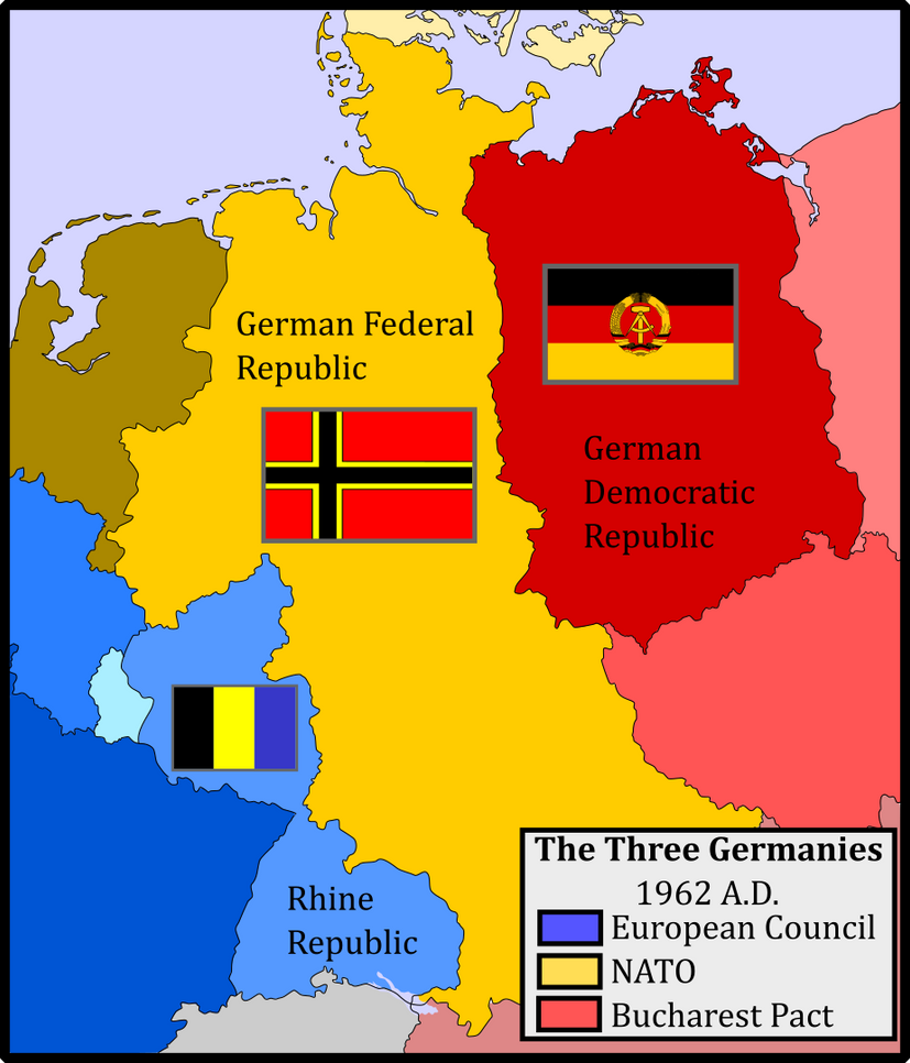
---------------------------------------------------------------------------------
In the spring of 1945, General George S. Patton received a command from General Eisenhower. The third army was to halt its advance before Prague, lest Patton's soldiers accidentally came into combat with Soviet soliders.
Patton, seeing the Soviets as a greater threat than the Nazis ever could be, ignored his lawful orders, and sent loyal men ahead. The news of the skirmish reached both the Allied and Soviet command quickly, but before Eisenhower could reprimand Patton and calm down the Soviets, Patton had pushed into Prague, his forces openly firing upon Russian soldiers. World War III lasted only four months before the ceasefire line was drawn, but when the dust settled, the Soviets had the pushed the iron curtain west past their treaty territories.
With the tensions high between the West and East, the U.S. had little time to initiate their de-Nazification plans in West Germany. They needed a strong ally at free Europe's eastern border, and were thus forced to let a great number of officers and bureaucrats that had been part of the Nazi state return to service. The French, appalled by the buildup in West Germany, were reluctant to integrate their occupation zone with that of the U.S. and U.K. While the French dithered with the territory for a decade, one of Charles de Gaulle's first actions as the first Consul of the French Fifth Republic was to officially separate the occupation zone from Germany, establishing the Rhine Republic. Now, Germany is the center of world tensions, between the U.S. led NATO, French led European Council, and Soviet led Bucharest Pact.
