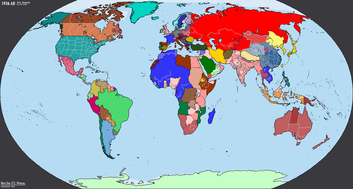
^Maybe I'm missing it, but no Comanche?

From Wikipedia: https://en.wikipedia.org/wiki/Comanche_history

"The Comanche were closely related in language and tradition to the Eastern Shoshone of Wyoming. The Comanche probably split from the Shoshone in the 16th century with the Comanche moving south to Colorado and becoming, as did the Eastern Shoshone, bison-hunting Great Plains nomads. The movement onto the Great Plains may have been stimulated by wetter climatic conditions which permitted an increase in the bison population on the Great Plains.[2]"
 
rYAid5h.png


SVG was too big, PM me if you want it
 
Would someone be willing to modify the 1936 Next-Gen Worlda map to create two Worlda maps for January 1, 1938 and November 1, 1938? I need them for a map game, and I will credit whoever fulfills this request.
1936.png
 
Does anyone knows how big the Russian enclave of the Baikonur Cosmodrome should look like on a map?, I have seen people make it a very big circle which also includes nearby cities, or just making the smaller city itself be a Russian enclave, but are there any "official" maps that say what the area looks like on a map?
 
I need help drawing the volga river. I'm making a map located at 500-800 and I already made the coastlines but I wanted to add some rivers to the map. I have a major problems drawing the rivers in the Caspian Sea since at this time the level was -10m / 12m
Here is the map i made.
image (33).png


This is a map I found but the projection doesn't fit.
1710978293483.png
 
Hello, I need maps of the administrative divisions of pre-1951 (PRC annexation) Tibet, and the internal subdivisions of the 1912-1992 Xinjiang Province of the Republic of China, does anyone has them?, I hate to put pressure on people, but I would really want a map for them as fast as possible, since I need them to finish a map with a deadline, before another forum user leaves the site in April.
 
Dear fellows, I have recently been contemplating what a city named ‘New Amsterdam’ which was NOT a copy-past of New York City might look on a map: my key inspiration was to make this a city based on what NYC might look like as an East Coast metropolis, not THE Metropolis of the United States.

Having looked at the list of Most Populous US cities, I noted that there were a number of historic & interesting US cities on the Atlantic Seaboard in the 600,000-900,000 residents range: looking up the population of New York City over time, the last point at which the cities’ population was so small is at some point between 1860 and 1870.


However, this was quite so time ago, so I’m not quite sure how to update the geography of a 19th century city to suit a 21st century burg: I would like to distinguish any map of New Amsterdam from it’s original to a degree sufficient to make it seem a ‘little sister’ to NYC and to make that smaller size seem plausible in context.

May I please ask for suggestions on how I might accomplish one or more of these ambitions? (For the record, this city is meant to be a City of Adventure for a superhero setting, so there’s a certain amount of room to ignore national geography, so long as the local geography of the city itself looks convincing).

Simplest way I can think of is to with OTL New Amsterdam (ex: southern part of OTL Manhattan) and then extending from there in a different direction than OTL NYC (ex: the rest of OTL Manhattan then up the peninsula to include OTL Queens, Yonkers, MT Vernon, Pelham & Pelham Manor.)
Smaller towns OTL could have a larger density to allow you to end up with, say, 4 million people or else for the same density, have smaller sky scrappers but have them present further outside of Manhattan.
 
Last edited:
I couldn't find on Google Images, so I'd like to request the following flags for a Royal France based on those two: https://en.wikipedia.org/wiki/Flag_of_France#/media/File:Flag_of_France_(XII-XIII).svg and https://en.wikipedia.org/wiki/Flag_of_France#/media/File:Flag_of_France_(XIV-XVI).svg . A 2:3 and 3:5 for each.
Just to get pedantic, those are not "flags of France", they are banners of arms meant to represent the *king* of France.

The reason I point this out is that, like many other monarchies at the time, the french used a number of flags and which one would end up being a "National Flag"
might vary depending on which element of french society was responsible for adopting this National Flag.

In other words, depending on the POD, you might have more adequate contenders.
 
I'd like to request a redesign of the Arcasian flag from Suzerain. The official version is way too busy for my tastes.

bEBsafWKZtXvKtKLY1eab_carcasia3x.png


Top