You are using an out of date browser. It may not display this or other websites correctly.
You should upgrade or use an alternative browser.
You should upgrade or use an alternative browser.
Proposals and War Aims That Didn't Happen Map Thread
- Thread starter Beedok
- Start date
Faeelin
Banned
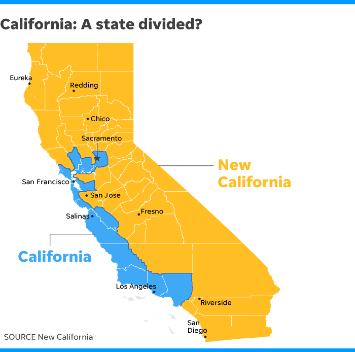
This proposal for a divided California just hit the news. It's similar to Jefferson in that it's ultimately a bid for political representation.
Pff, representation. I don't see any reason to let people in the gold regions have the right to vote.
The-Artist-64
Banned
Well, I can understand why the interior counties would want to chart their own course given California's recent history. Every man should have the right to voice his opinion, and the urban-rural divide has created a lot of problems when it comes to this. On the other hand, I can agree with you in that I would try to package the proposal to appear as more of a solution to the state's problems than a gerrymandering "duct tape fix".Pff, representation. I don't see any reason to let people in the gold regions have the right to vote.
Seconded. It'd be a nice to have a worlda for that!Does anyone have a good map showing the Treaty of Tordesillas line in full?
")
This doesn't actually fix the rural/urban divide anyway, because "New California" would still be dominated by coastal urban centers, particularly San Jose and San Diego. Also: "New California" is a ridiculous name.Well, I can understand why the interior counties would want to chart their own course given California's recent history. Every man should have the right to voice his opinion, and the urban-rural divide has created a lot of problems when it comes to this. On the other hand, I can agree with you in that I would try to package the proposal to appear as more of a solution to the state's problems than a gerrymandering "duct tape fix".
Burton K Wheeler
Moderator
This proposal for a divided California just hit the news. It's similar to Jefferson in that it's ultimately a bid for political representation.
This is a Chat topic, discuss it in the thread there. This thread is for history, not contemporary politics.

Does anyone have a good map showing the Treaty of Tordesillas line in full?
In Wiki you can actually find a huge version of the Cantino planisphere that you can easily read (if you're familiar with paleography and 16th century Portuguese). It's quite interesting to see how present day toponymy can be traced back to these first navigations.

The proposed division and occupation of Japan by the allies after World War II. The Soviets would occupy Hokkaido and Tōhoku, American would occupy most of Honshu, the British would occupy Chūgoku and Kyushu, and the Republic of China would occupy Shikoku.
Tokyo would be a multinational occupation zone and Osaka would be jointly administrated by Britain and the RoC.
The division of the United States as proposed in the 1864 map Our Country as Traitors and Tyrants would have it.
This proposed that, through intervention from Britain and France, the Confederacy would gain independence and greater land, while the Union would be fractured into three nations: the Pacific States, the Interior States, and the Atlantic States.
Was there any plan for the multinational occupation zone and Osaka if/when Communist China kicks the ROC off the mainland during the Chinese Civil War?View attachment 366545
The proposed division and occupation of Japan by the allies after World War II. The Soviets would occupy Hokkaido and Tōhoku, American would occupy most of Honshu, the British would occupy Chūgoku and Kyushu, and the Republic of China would occupy Shikoku.
Tokyo would be a multinational occupation zone and Osaka would be jointly administrated by Britain and the RoC.
Faeelin
Banned
Was there any plan for the multinational occupation zone and Osaka if/when Communist China kicks the ROC off the mainland during the Chinese Civil War?
Since we didn't get this division, I assume it became moot right?
Was there any plan for the multinational occupation zone and Osaka if/when Communist China kicks the ROC off the mainland during the Chinese Civil War?
I'm fairly certain when it was drawn up in mid 1945 the planners were not considering it likely that the communists would take over China. In any case Chiang Kai-shek was never keen on actually occupying Japan so he may never have sent more than a token force
That map makes me question if the Soviets even had the capability of launching an invasion on Hokkaido, much less Tōhoku.
Here is a quick Worlda patch for Talleyrand's partition plan for the Southern Netherlands. If someone can make it more accurate please do.

That map makes me question if the Soviets even had the capability of launching an invasion on Hokkaido, much less Tōhoku.
They had the plans yes. And the ships. The plan was to land at Rumoi in Hokkaido. They also conducted various amphibious landings in southern Sakhalin, the Kurile Islands and in northern Korea.
That map makes me question if the Soviets even had the capability of launching an invasion on Hokkaido, much less Tōhoku.
They don't have to take all of the occupation zone to be allocated it in the post-war division. The Soviets didn't occupy all of what would become OTL East Germany at the end of WWII.
Rosa Luxemburg
Banned
Maybe the RoC could find refuge in their occupation zone?Was there any plan for the multinational occupation zone and Osaka if/when Communist China kicks the ROC off the mainland during the Chinese Civil War?
Share: