Map Thread XXI

Status
Not open for further replies.
image.png


I am back with some more Anbennar ! Here, I have displayed as of update 15 the dominant "races" (in the fantasy sense) of Halann, by province.
Obviously, Humans are broadly dominant in Western Cannor and Haless, but the aftermath of the Greentide and Greytide is clearly visible in the Serpentspine, Escann and Gerudia.
And of course, as of 1444, the Ruinborn are the only sapient race present in Aelantir.
Please note that Sarhal is probably going to be released in update 16. The situation is comparable in Insyaa : It's not that there aren't meant to be any people there, it's that we don't know who lives there yet. ;)

Same as last time, this is also getting posted on my DeviantArt and Reddit.
Sheesh! That's a ton of races!
So far, I really like the development of your world and countries 👍
 

Zillian

Gone Fishin'
Not sure, but Gimp and Photoshop both have it.
I think I have found it at Photoshop. Is it Trace Contour? I can see it has a scale between 1 and 255. How do I use it? Copy the province map in a new layer, chose a low number, and then repeat as I work up, and finally merge layers?
 
I think I have found it at Photoshop. Is it Trace Contour? I can see it has a scale between 1 and 255. How do I use it? Copy the province map in a new layer, chose a low number, and then repeat as I work up, and finally merge layers?
Not sure what it's called in Photoshop. I use Gimp, and it's just called "trace". The options I use are "Gradient" and the number doesnt matter.

Add an alpha channel to the layer, colour pick the bg colour (usually black), and delete. Colourise the layer to be all black. Create a new bg layer (white or whatever colour you wish) and place it under the lines. Flatten the image.
 
image.png


I am back with some more Anbennar ! Here, I have displayed as of update 15 the dominant "races" (in the fantasy sense) of Halann, by province.
Obviously, Humans are broadly dominant in Western Cannor and Haless, but the aftermath of the Greentide and Greytide is clearly visible in the Serpentspine, Escann and Gerudia.
And of course, as of 1444, the Ruinborn are the only sapient race present in Aelantir.
Please note that Sarhal is probably going to be released in update 16. The situation is comparable in Insyaa : It's not that there aren't meant to be any people there, it's that we don't know who lives there yet. ;)

Same as last time, this is also getting posted on my DeviantArt and Reddit.
What, uh... what is Harimari, Ruinborn, and Degenerated elves?
 
Tiger-people.

You see how there's a suspiciously circular shape in the western continent.

That was a BIG BOOM(TM). The people living around them are post-apocalyptic elves.
Yeah. In Fallout terms, Ruinborn are Wastelander Elves.
The Degenerated Elves are... Kinda like feral ghouls ? or Super-Mutants ?
And of course, Aelnar... is the Enclave.
 
A map of the world in 740 for this scenario. PoD is the nonexistence of Islam. I decided not to go the usual route with this PoD of wanking the Roman Empire, but instead went with a Miaphysite Christian Arab empire and a conquest of Persia by the Neo-Göktürk Empire under Qapaghan Qaghan.
Notes:
- The Neo-Göktürk Empire broke into four parts after Qapaghan's death, the Khanate of Persia (Inäl Ulush), the Khanate of Transoxiana (Eltemish Ulush), the Sirkhanate (Kültegin Ulush), and the Orkhon Khanate (Gök Ulush). The Khanate of Persia and the Sirkhanate have expanded since Qapaghan's death, while Transoxiana lost more than half of its land to China in the early 730s.
- Lǐ Lōngjī was married to a daughter of Qapaghan Qaghan, resulting in Princess Tàipíng winning the power struggle following Wǔ Zétiān's removal and death. Princess Tàipíng became Emperor, and was succeeded by her son Wǔ Chóngmǐn. Due to the return of the position of Emperor to the Wǔ clan, the dynastic name was restored to Wǔ Zhōu.

Screenshot_2023-03-03_at_8.30.30_PM.jpg
 
PFSR.jpg

Not a super great map but the idea of a post-zombie apocalypse Great Plains/West after watching part of the "Last of Us" and the first episode of the 1987 "Amerika" miniseries. In this scenario somehow the Great Plains are less effected by the zombies than other areas and are able to clear out the hoards. Then at some point, the government nationalizes most industries to try to get the economy working again or something.
There isn't really any lore behind it because I just wanted to make the map because I think a weird semi-successful Socialist Great Plains feels cozy in the same way as being inside a house during a massive thunderstorm at night does.
 
Last edited:
View attachment 815019
Not a super great map but the idea of a post-zombie apocalypse Great Plains/West after watching part of the "Last of Us" and the first episode of the 1987 "Amerika" miniseries. In this scenario somehow the Great Plains are less effected by the zombies than other areas and are able to clear out the hoards. Then at some point, the government nationalizes most industries to try to get the economy working again or something.
There isn't really any lore behind it because I just wanted to make the map because I think a weird semi-successful Socialist Great Plains feels cozy in the same way as being inside a house during a massive thunderstorm at night does.
Its all fun and games until the zombies come for your maize crop.
 
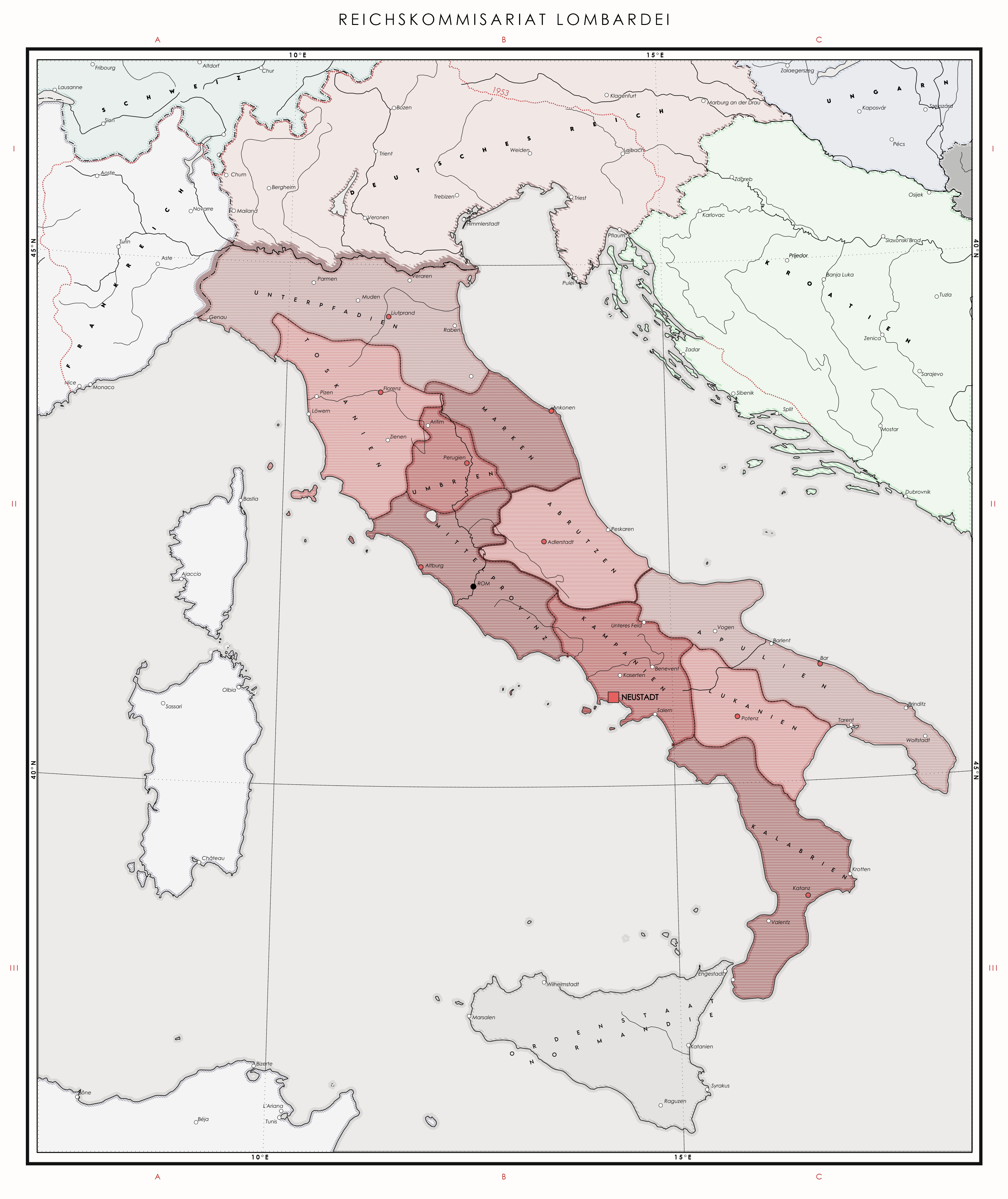
Italy in the wake of the Italo-German War of 1953

dfqv2vz-7f692e7f-fd1c-4014-b33b-5d42414a6075.png

Following Himmler's ascension as Reichsfuhrer in 1950, Italo-German relations, already strained after the Suez Crisis, have reached their boiling point. Fuhrer's conviction that their Italian allies were no longer of any use to the German Reich, topped with his growing unease over the development of the Italian nuclear program have led him to believe that firm action needed to be taken. After publicly denouncing Italy's oppression of Tyrol Germans in a Reichstag speech on January 1st, 1953, a plan for a swift conquest of Italy was conceived in the German general staff. It was executed mere months later, on June 22nd, 1953. A nuclear strike on Rome decapitated Italy's defensive capabilities in an instant, and with a significant portion of its forces committed to suppressing the East African rebellion, Italy proved to be incapable of putting up any significant resistance and the remainder of Italian forces was quickly overrun by Reichswehr divisions. In the wake of this instant campaign the Kingdom of Italy ended its existence. Former provinces of Tyrol and Lombardy were annexed directly into the Reich. Some portions of the former kingdom were given to members of the Stahlpakt in reward for their loyalty: France has retrieved its lands previously ceded to Italy in 1940 with a slight surplus and regained control over its North African possessions; Dalmatian provinces were given to Croatia. Sicilly was made into an SS Ordenstaat, and no news have been able to get out of there ever since. The remainder of Italy was organized into Reichskommissariat Lombardei, named thusly after the Germanic medieval kingdom that once ruled it. Despite its efforts the Reichswehr was unable to restore control of the Italian East Africa, which had fallen to the communist forces.​
 
Last edited:
Italy in the wake of the Italo-German War of 1953

dfqv2vz-7f692e7f-fd1c-4014-b33b-5d42414a6075.png

Following Himmler's ascension as Reichsfuhrer in 1950, Italo-German relations, already strained after the Suez Crisis, have reached their boiling point. Fuhrer's conviction that their Italian allies were no longer of any use to the German Reich, topped with his growing unease over the development of the Italian nuclear program have led him to believe that firm action needed to be taken. After publicly denouncing Italy's oppression of Tyrol Germans in a Reichstag speech on January 1st, 1953, a plan for a swift conquest of Italy was conceived in the German general staff. It was executed mere months later, on June 22nd, 1953. A nuclear strike on Rome decapitated Italy's defensive capabilities in an instant, and with a significant portion of its forces committed to suppressing the East African rebellion, Italy proved to be incapable of putting up any significant resistance and the remainder of Italian forces was quickly overrun by Reichswehr divisions. In the wake of this instant campaign the Kingdom of Italy ended its existence. Former provinces of Tyrol and Lombardy were annexed directly into the Reich. Some portions of the former kingdom were given to members of the Stahlpakt in reward for their loyalty: France has retrieved its lands previously ceded to Italy in 1940 with a slight surplus and regained control over its North African possessions; Dalmatian provinces were given to Croatia. Sicilly was made into an SS Ordenstaat, and no news have been able to get out of there ever since. The remainder of Italy was organized into Reichskommissariat Lombardei, named thusly after the Germanic medieval kingdom that once ruled it. Despite its efforts the Reichswehr was unable to restore control of the Italian East Africa, which had fallen under communist forces.​
Well, this should solidify the hatred and wariness of the Nazis in the US and the Southern Cone. Depending on how the nuclear weapon was delivered, and the assumed range of it, I can see any German populations of Latin America who have not shown themselves to loath the Nazis (or having lived in South America for generations) will be locked up as potential fifth columnists, with the American nuclear umbrella being lifted over them. Really, if the Germans obliterated the Italians (and the Vatican City) out of a minor suspicion that might not have even been made public, despite Hitler adoring them, then what do all the other countries with their populations that include mixtures of Slavs, Natives, etc hope to fair? And since so many emigrants from Italy were Sicilians... Yah, going to be some suspicion that Italians overseas would be classified as subhumans.

Do you see all those people with their own languages in the Italian Alps get Germanized quickly or looked at with suspicion? What was the Sues Crisis here anyways? Did the Italians get more land from France in this world, or did they keep to the very small IOTL gains? Some would say it was ingratitude for taking so much for France to get it, but others would see it as a blessing. My, I wonder what France must look like here. Are Albanians going to be at risk here, or will they be seen as Turks or the basic equivalent of Finns and Hungarians, in that they are alien but have plenty of good soldiers in their history? Ahh, and is the grey area in Banat Romania? I suppose the Germans would need a lot more settlers in this world, so would get as many Germans out of the Balkans as they could.
 
nurgan_final_product.png

My first ever map! I always wanted to make an alternate history map, but I am terrible coming up with plausible alt history scenarios, so I decided to test my map making skills on an OTL Nurgan RMC, a military commission established by the Ming dynasty in modern day Manchuria. I originally wanted to do a QBAM/World-A map, but there were two issues with it. The RMC didn’t have any administrative divisions and was instead controlled by a bunch of guard outposts scattered throughout Manchuria. QBAM/World-A was too small, so I had to resort to using VT-BAM to show all the outposts. According to sources during the Ming dynasty, Nurgan at its peak had over 384 outposts, but I couldn’t find a map that had all of them. I’m not sure how many outposts are there on my map, but it’s a lot! According to the map I used as a source, the forts I showed are roughly the locations of the outposts in 1422.

As for designing the map, all of the rivers were hand traced, and the fort symbols I used was pixel art created by me. It was my first time doing pixel art, so it doesn’t look super good, but it looks alright from a distance. One of the forts in the map have a yellow flag on top, and this fort represents Nurgan City, which was the capital of Nurgan RMC. Georeferencing the source map and tracing the rivers were quite tedious, but I'm quite happy with the result I got for now.

I hope you all like this map! Feedback would be appreciated for my first map! Thanks for reading!
 
Status
Not open for further replies.
Top