Crosspost with the WIP thread. This is a WIP of a 50s punk map.
Not so much Mega (Lake) Chad, as GIGA (Lake) Chad!

Also, you have built several canals.
Crosspost with the WIP thread. This is a WIP of a 50s punk map.
Atlantropa: Lake Chad vs. Virgin MediterraneanNot so much Mega (Lake) Chad, as GIGA (Lake) Chad!
Not sure I get the reference here.LILITH!!!!!!!
References to George Washington as 'Town-Burner' are peppered here and there in literature talking about Sullivan's Expedition. The Visions of Handsome Lake provided the actual Seneca name for him. The Quote is ATL, but borrows from things both Cornplanter and Handsome Lake said in OTL.I am speechless. There is literally only one other thing on google using the word Renadagaius. Did you find it from that 1955 text or read it up somewhere else? I can never be sure when quotes on here are OTL or ATL. On a side note, was this from before Maryland annexed Delaware?
Why is the whole Earth not yet populated a thousand years after the Miracle? Even .5% annual growth (a very low rate, given the plentiful resources untapped) should give you 150 Frances worth of people by the time of the last maps.
Soooo a similar premise to the Terra Nova series? Cause thats sweet I always loved this idea and this map and write up sound and look greatA cross-post from the current MotF round, and the final version of my WIP the other day...
BACKGROUND
The Ann Arbor Anomaly is best described a portal leading to central North America during the early Cenomanian Age of the Cretaceous, approximately 100 million years ago. The portal is perfectly circular, usually around four feet in diameter, and is only visible and accessible from one side. The size of the portal fluctuates; when first observed it was only a few inches across, then expanded to approximately its present size over the course of three days. Since then it has varied between three and six feet in diameter, with no discernable pattern to the changes.
DISCOVERY
As the name suggests, the Anomaly is located in Ann Arbor, Michigan, where it seems to have appeared in a park on the night of November 12, 2019. It was discovered the next morning by Aidan McKinney, who was walking his dog in the park when he noticed a plume of vapor condensing out of what seemed to be a small hole in the air. Mr. McKinney notified some friends of his, who briefly ventured through to the other side. There they found a humid jungle environment with unfamiliar fauna, including some unmistakable dinosaurs. The group attempted to notify the authorities, but were initially disregarded until photographic and video evidence was provided and independent confirmation from other sources was received. A variety of experts from the nearby University of Michigan then took over the scene until federal authorities arrived to secure the anomaly.
EXPLORATION
In the two years since the appearance of the Anomaly, a number of expeditions have gone through to the far side, and a substantial facility has grown up on both sides of the portal. The main bottleneck has been the limited size of the portal, making it difficult to transport large equipment. Outside the facility on the far side, there are three zones:
- Zone 1 is the immediate area around the anomaly, which has been thoroughly explored and mapped. Most of this zone is a humid rainforest, part of the drainage basin of the Cope River, which runs west to the Mowry Sea.
- Zone 2 stretches about as far as the shores of the Atlantic and the Mowry. Most of this has been mapped by solar-powered drones, so major land features are known. Some manned expeditions have taken place, mostly cataloging the flora and fauna.
- Zone 3 has been cursorily explored by the newest long-range drones, mostly mapping the shorelines as part of the effort to date the far side by comparing landmasses to geologic data.
- Zone 4 is anything not yet surveyed; landforms in this region are based on geological conjecture only.
SCIENTIFIC CONTROVERSIES
The cause of the anomaly is unknown. A popular theory is that the anomaly was somehow caused by the GLC particle accelerator in Japan, which had gone into operation only a few days previously. However, so far there is no evidence to support this, and activity at the GLC does not seem to correlate with observable behavior of the portal. The portal emits a unique radiation signature when contracting or expanding; based on this signature, physicists have detected two other possible anomalies (one in New Mexico and one in California), but both have been microscopic in scale and lasted only a few seconds.
There is also an ongoing debate over whether the far side is our direct past, or some type of alternate timeline. Efforts to plant an object on the far side that could be retrieved in the present have so far been unsuccessful.
The exact date on the far side is still being narrowed down based on astronomical and geological data. The current estimate, based on some new bathymetric survey data from the Mowry Sea, is 99.7 ± 0.3 million years before present.[/ATTACH]
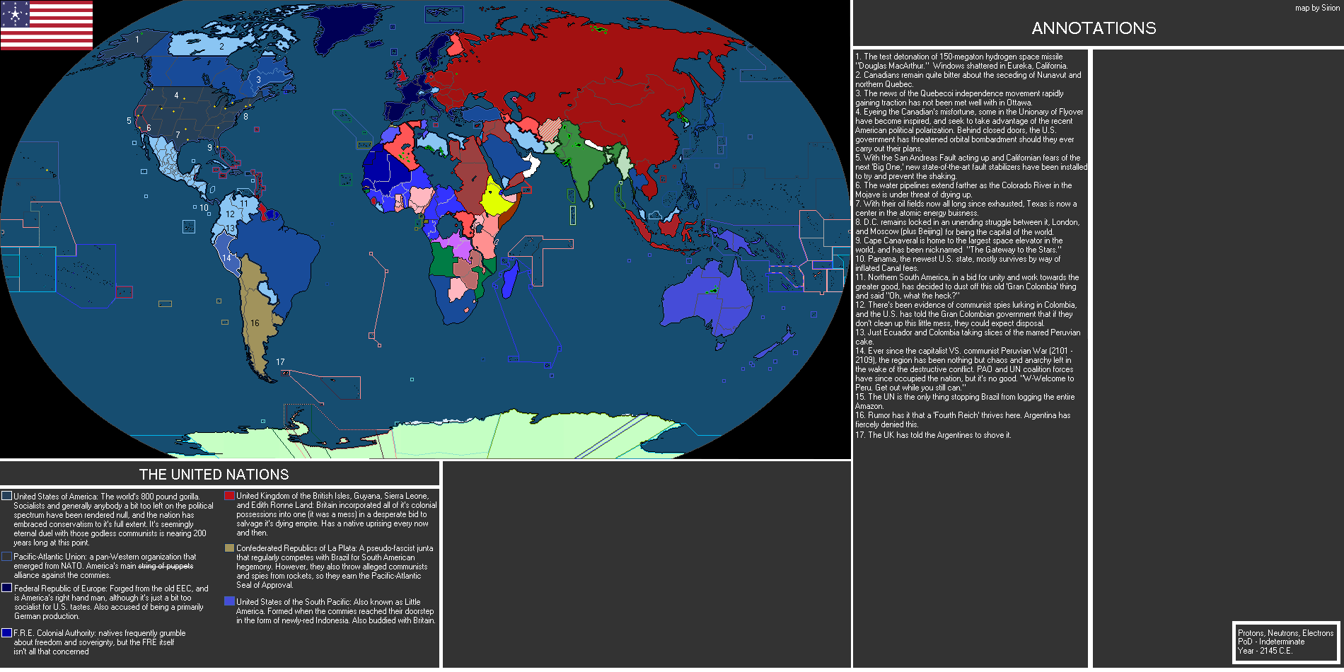
Generic Soviet Union victory map in the cold war. First map/scenario on here so feel free to critique:
View attachment 374816
Crosspost with the WIP thread. This is a WIP of a 50s punk map.
AN ELBA THE SIZE OF THE EARTH
A NAPOLEON ISOT
Comments and critiques welcome, as always!
Yes, the pink nation is Haiti. Eastspeak is a sort of French-leaning French/German hybrid (which is a lot like a description of English now that I think of it), and Occitan is the OTL already-existing language family of the Occitan culture of southern France.I really love this! I love the idea of showing various stages of the IOST on one map, and the religion and language. I also like the somewhat realistic growth of France here. Few questions though. Is the Pink nation supposed to be Haiti? Also, what are the languages of Eastspeak and Occetain?

It's almost certainly a Neon Genesis Evangelion reference. In which, in the film that capped off the original series, Lilith reformed from merging with her human avatar and literally brought all of humanity unto her bosom. By appearing before them in said human avatar, hugging them, and turning them into tang.Not sure I get the reference here.
What sort of administrative reform happened? The borders of the counties look pretty much unchanged.POD: Earlier Habsburg Hungary, no Turkish occupation
snip image
The Kingdom of Hungary after the administrative reform of 1861
I am guessing the Kingdoms of Croatia and Slavonia were completely swallowed up. Perhaps it would have something to do with no need for the Military Frontiers. Or a greater need. Come to think of it, someone could probably get a decent map out of completely depopulating the Croatian, Slavonian, Transylvanian, and Banat Military Frontiers and filling them with Magyars, Germans, whatever. Horrible for the people who were dispossessed, and pretty unwise given how it is not like the soldiers would have wives and large families or keep populating the area with.... But hey, how often do we see maps of good things anyways? No, misery is what makes the AltWorld go round. Excluding Male Rising.What sort of administrative reform happened? The borders of the counties look pretty much unchanged.
Any reason why Salt Lake City is not at the Great Salt Lake?
Before:What sort of administrative reform happened? The borders of the counties look pretty much unchanged.
View attachment 375275
A mini-map about alternate North America in 1825.
Premise: New France somehow survives, and later becomes the USA of this timeline.
Also: New Netherland; two english-speaking states: slaveholding Columbia and FRA-influenced New England; multi-cultural, revolutionary, and fairly democratic Free State of El Dorado (founded by spanish, french, english and russian settlers); Mexican Empire; independent Florida (with columbian settlers); and Russian America. Northeastern Canada remains unclaimed and unsettled (for now); however, Danish crown seems to preparing for claim the land soon.
Darker color depicts territories, paler with dark-grey border depicts indian reservations.
