After the Battle of the Burg, it became evident that whatever strange Scottish culture lived to the west did not want to speak to Europe. While more exploratory missions were sent, any ships that ended up trespassing into their sea were quickly taken. While they discovered Lulachfrýgyld in 1456, Europe didn’t even know the name of the confederation until the 1480’s. It took the occupation of one of Lulachfrýgyld’s southern cities that finally got them to confront the old world. The first official diplomatic missions were made by the English, who had their minds set on colonizing the strange culture that was somewhat similar to their own. King Waefyrnn I of Merscha agreed to meet with a Christian priest from Cardiff, allowing the two people to build something of a mutual understanding. In 1489, any voyage from the Europeans was celebrated in Edscóníeg, even if most of the kings from the north despised the English. Ultimately, the “New Europeans” were seen as something of a novelty; they were nice, and could provide for them, but ultimately they would never be allowed to rule over Lulachfrýgyld. Some people saw them as weak. People who had lived in the “New World” all their lives made fun of Europe for not noticing them sooner. They made fun of the English for turning so French-like, and the Scottish for succumbing to the Danish. Ultimately, while the kings might have accepted meetings, they were intent on banning colonization. The one group they didn’t hate were the Scandinavians, which would come into play later on.
By the early-1500’s, the Ældenglic (the group term for the “Old English” who lived in Litirland) were still holding up. The various kings on the coast, who had spent years feuding with one another for resources, made a pact to occupy any ships sent on violent terms. Europe was fearful of the west, and began to lower their threats of colonization and even diplomacy. The only colonies that were eventually made were created in the south. Scandinavia had the islands of Fennica (Cuba and Haiti), England began to colonize South Scotland (their name for Colombia and Venezuela), and Castile and the Byzantine Empire made a pact to explore the far reaches of the south together. Eventually, Lulachfrýgyld (or Frygia, as they were called by Europe) began to realize their weakness. They had spent the last three hundred years of their existence divided among shifted factions, and they would never have been able to fight a full-on war against any single one of the powers. Quickly, the kings of Oswalltea, Ceibhehionn, and Laloríce agreed to meet with Scandinavia, the only nation they revered for their competence and strength (they had taken over corrupt Scotland, hadn’t they?). In 1523, they allowed the Scandinavians free rights to settle the north, as long as they respected Frygian sovereignty. The King agreed, and sold the islands of Fennica to England not too soon after. Having free reign over the lands to the north, they wouldn’t need the scathing islands.
The first settlement, Camp Nyra, was formed in the far north, close to where the Chief of the Miquaka lost control. Other towns would eventually be formed farther south, but it felt best to leave the Frygians be for a couple decades at the least. Nyra grew in size as they found themselves trading with the Hálignausé and Arraillur, with the Scandinavian colonies eventually outnumbering the size of both nations combined. The 1520’s consisted of periodic wars against the Hálignausé for their expert location between Nyra and Frygia, concluding with the capture of Eio and Enga in 1528. But even through all this, the knowledge of the continent felt a bit lacking. While some ships had been sent to voyage down the Ibalhandia River (OTL St. Lawrence, with the name literally meaning “Great River” River), they weren’t sure where it lead, and if it would ever end at all. So, in 1531, an ambitious man named Hans Robertson was sent to meet a crew on a settlement close to the supposed end of the Ibalhandia. The journey that he planned out with the people of the settlement, known as Flyddelta, would take them around whatever lakes the Ibalhandia drained into, and south hopefully into the western reaches of Frygia. He was sent with the supplies needed to set up any temporary base, of which he eventually founded four. The voyage would ultimately take five years, two years longer than expected.
He set off from Flyddelta in the late summer of 1531, setting up many resting sites along the way. After realizing that the lakes were much larger than expected, he and his crew briefly rested in November, before picking up at the same pace a few days later. He wasn’t moving fast, and stopped many times to fish or to study the environment. Ultimately, after finally moving south, he founded Camp Indirflyd in February of 1432, ahead of schedule by some margin. Indirflyd was located in a nice area, and farms were set up as soon as spring fell upon the camp. Robertson saw it best to stay in the area at least until the next winter past, just so they would have enough food to continue onwards. Ships were sent down the river they discovered, where they were surprised to make contact with the Kingdom of Tapokasa, who had recently defeated their neighbor Breeshey in an eight-year war. The people this far removed had little knowledge of Europe, and didn’t know the Scandinavians had been given permission to settle in the north. With Tapokasa declaring war on Indirflyd, believing it to be a large city, Robertson realized that Frygia was not a singular entity, and changed his plan of crossing through Frygian lands to escape. Instead, they would only explore the coast, and avoid the western lands at all costs (or at least until the news reached them that Scandinavia was fine). The voyagers were forced to abandon Indirflyd in May of 1533, after having fought three Tapokasan and Cascannopan ships in a crippling battle.
From there, two more settlements were set up, as the crew began to rebound from the battles. Langue was established on October 16th, 1533, and Langskip was launched a week later. The two settlements were meant to allow trade to Nyra and the coast, while also allowing for exploratory missions on the interior. Trade was made with the more peaceful Cheroci tribes, as well as the kingdoms of Govannona and Puwhata. The towns were necessary to last the crew through the winter, as they traded to get food until they could farm through spring. They agreed to move on from the profitable colonies by the end of harvest season 1534, agreeing to form their final settlement somewhere along the Frygian coast. Ever since realizing that Frygia was not a singular entity, Robertson got the impression that the population of each individual kingdom could be no smaller than the smallest of European towns. However, he was wrong, as some of the principalities had thousands of people, and the coast was almost entirely settled by the Ældenglic at this point. It took a voyage to the far south, past the same kingdom the English had met with decades earlier, to find a suitable place to set up a town. They chose to help the Kingdom of Caedda to fight off the native Confederation of Schenga, where they were rewarded with a large plot of land. With that reward, Camp Umbúðir was created. Objectively, Umbúðir was the most profitable camp, as the kingdoms they traded with were peaceful and sometimes provided gifts. While it wasn’t easy to farm the swampland where the plot was located, they had plenty of food from the cities right next door. During the two years they stayed there, Umbúðir grew in size, with Ældenglic settlers outnumbering the remaining crew of fifty-eight (there were originally eighty crewmembers, but some had died off in the four years they explored for). What ultimately set them behind their three year plan was the fact that they stayed in Umbúðir for over a year, with Robertson eventually picking one of his mates to rule the city-state after his departure. The town would eventually become one of the many Frygian kingdoms, and one of the only ones to identify with Scandinavian culture. The crew nominally chose not to return to Nyra, as they had already explored most of the coast. Instead, Robertson ambitiously chose to voyage out to sea, where he ironically died. His remaining crew would carry on the journey, docking in Aberdeen on November 16th, 1636. His right-hand man, Jon Herbergison, would go on to form eight settlements in the Scandinavian colonies, leading the entire region to be named after himself (Herbergia). Hans Robertson’s journey would become known as the Langlífrejr, and it allowed the Danish a good view of all the places in Litirland.
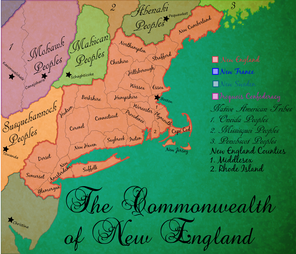
") Unfortunately, most of them have been displaced. I believe I addressed their status in Georgia specifically earlier (they got ethnically cleansed a bit) and their status in the northern Kingdoms (mostly peaceful co-habitation/assimilation), but their status in the mid-Atlantic kingdoms is somewhere in between (persecuted, but not all-out war). Some of the remnants are either moving east of their own accord or being forced across the extremely porous border with French Louisiana by one Kingdom or another.
Unfortunately, most of them have been displaced. I believe I addressed their status in Georgia specifically earlier (they got ethnically cleansed a bit) and their status in the northern Kingdoms (mostly peaceful co-habitation/assimilation), but their status in the mid-Atlantic kingdoms is somewhere in between (persecuted, but not all-out war). Some of the remnants are either moving east of their own accord or being forced across the extremely porous border with French Louisiana by one Kingdom or another.