Almost certainly Kurdish. Armenia is to the north, part of the PIC.Is that orange state Kurdish or Armenian?
You are using an out of date browser. It may not display this or other websites correctly.
You should upgrade or use an alternative browser.
You should upgrade or use an alternative browser.
Affiliated States of Boreoamerica thread
- Thread starter False Dmitri
- Start date
View attachment 533586
so i know i haven't done a lot on this thread, but i might as well jump in with my ideas from the middle east. i haven't fully fleshed out any countries yet but here's my general ideas
- ottoman empire does gain control over middle east but soon falls apart
- arab states form without european influence but ally with other nations
- oman, najd and persia are more powerful states and persia is an ally to the russo-swedish-polish mega-monarchy
but i still haven't made up my mind. so, thoughts?
Any ideas as to the timeline when this developed?
And by ally, do you mean it's an ally today, or more of a permanent ally/client?
Last edited:
I put my reply on the wrong side of the quote-box.typo?
Kosta
Banned
View attachment 533586
so i know i haven't done a lot on this thread, but i might as well jump in with my ideas from the middle east. i haven't fully fleshed out any countries yet but here's my general ideas
note: i am considering persia's borders extending to the indus river, like so:
- ottoman empire does gain control over middle east but soon falls apart
- arab states form without european influence but ally with other nations
- oman, najd and persia are more powerful states and persia is an ally to the russo-swedish-polish mega-monarchy.
View attachment 533587
but i still haven't made up my mind. so, thoughts?
Hey man, I'm glad someone else around here is specifically interested in the ME and North Africa.
I asked Ben awhile back if I could plot out the Russian takeover of Constantinople. There is no way I can see Constantinople being taken without the Ottomans completely falling apart into nothingness. I think that Nader Shah will be instrumental in pushing the fall of the Ottomans. I wanted to keep the Safavids around for a lot longer, but as it stands, I don't think anyone in the area could take on the Ottomans let alone take them out, so we'd need to shift the timeline that leads to Russian troops inside the Ayia Sofia into the 1700's. Although the Celali Revolt crashed hard, the Shia still have some shooters out in Anatolia in the form of the Alevi. It is absolutely in the best interests of the Persians to whip them up into a frenzy. They might not need much of a push if the Sublime Porte suffers defeat after defeat after defeat in the Balkans. I foresee a Persian state going from central Anatolia to Sindhistan, at least for the 18th and 19th Centuries. Nader Shah played both sides of the Islamic divide by trying to shoehorn the Jafari school into Sunnism as the fifth (or sixth) school of jurisprudence. That in and of itself would be a bizarre turn for Iran. The Kurds would probably exist as some sort of fiefdoms within the great Iranian state and not have to worry too much about policies coming out of Tehran: the same goes for the tribal people up in Afghanistan and what we call the 'Stans in real life. For at least a good 1-200 years, it'll probably just be the Iranians and Russians as megastates out in the area.
This time period is sort of the heyday of Maronite-Druze relations. Those two groups would do pretty well as their own independent polities. Any concept of an Arab-only identity is still centuries away. The Safavids I recall a history major friend of mine telling me had Armenians in Lebanon as their emissaries. They might also be able to get their hands on the Levant--if they're not imperially overstretched.
The Safavid shahs and Nader Shah were all great at playing super minority shuffle. They'd be movin' Turks and Kurds all over the place, maybe even move some actual Persians in. The ethnic and religious makeup of Anatolia will be changed forever.
Last edited:
ST15RM
Banned
like an ally todayAny ideas as to the timeline when this developed?
And by ally, do you mean it's an ally today, or more of a permanent ally/client?

Here's a new update, filling as many cities as I could: (by the way, the "X"s in Ohio (OTL's Indy and Columbus) don't have names yet)
Columbus and Indy were only placed where they were to be centrally-located state capitals, so there's no reason to assume they'd be important sites in TTL.
Gian
Banned
Columbus and Indy were only placed where they were to be centrally-located state capitals, so there's no reason to assume they'd be important sites in TTL.
I'd still need names for them just because. And perhaps they can be made into rail hubs instead (simply between Two Forts and St. Louis through Pekoui) @False Dmitri
Last edited:
If I were in charge of building railways through Ohio, I'd place the St Louis-Two Forts rail line through Vincennes or Evansville and Louisville, not through *Indianapolis. Columbus, probably, but not Indianapolis.I'd still need names for them just because. And perhaps they can be made into rail hubs instead (simply between Two Forts and St. Louis through Pekoui) @False Dmitri
Gian
Banned
BTW @False Dmitri, I noticed you placed Roanoke in Upper Virginia, like so:
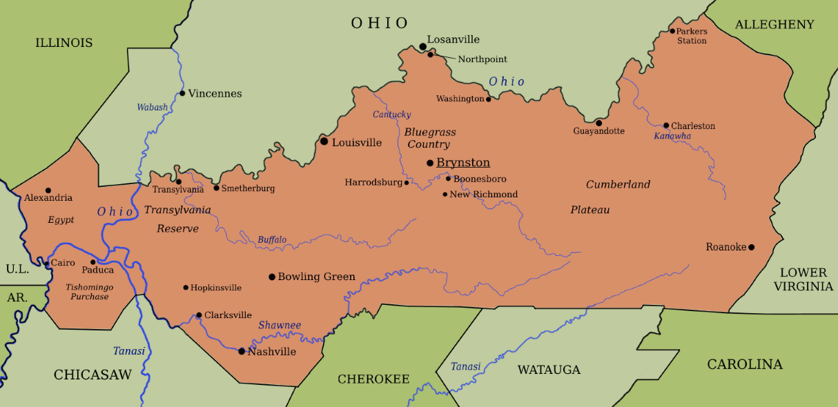
But I noticed the border is actually placed well to the west of OTL's Roanoke. (#31 in this map is OTL's city of Radford, which is close to where you placed Roanoke in)

But I noticed the border is actually placed well to the west of OTL's Roanoke. (#31 in this map is OTL's city of Radford, which is close to where you placed Roanoke in)
BTW @False Dmitri, I noticed you placed Roanoke in Upper Virginia, like so:
But I noticed the border is actually placed well to the west of OTL's Roanoke. (#31 in this map is OTL's city of Radford, which is close to where you placed Roanoke in)
At such time as I can access the layers of those maps, I'll take a look, but that might not be for a while. The city was intended to be the same Roanoke as in TTL, and the maps I traced showed it as such.
Regarding Indianapolis and Columbus, I agree with @erictom333 that there should be important local towns in those general regions, but that they should follow the key trade and rail routes of TTL rather than follow the sites that happened to emerge in OTL because of government choices. I'll see what I can sketch out with my limited means now. Same for Illinois.
Gian
Banned
Well, here's basically what I used: Upper Virginia's map overlayed with OTL's map of Virginia counties and cities:At such time as I can access the layers of those maps, I'll take a look, but that might not be for a while. The city was intended to be the same Roanoke as in TTL, and the maps I traced showed it as such.
Of course, but you know, with different projections and such tracing maps can be inexact, especially when you switch basemaps. If you think it's a genuine error, you can leave Roanoke off the map for now.Well, here's basically what I used: Upper Virginia's map overlayed with OTL's map of Virginia counties and cities:
Gian
Banned
On a more serious note, I'm trying to cobble together a map of total COVID-19 cases by (ASB) state.
Still WIP atm (and very much reliant on best guesses and estimates based on the state borders and numbers by county). I'll probably start to tabulate a version of this for 1 April, followed by another one in 20 April, just to get a feel of what it looks like state-by-state.
EDIT: I even made a Google Sheets sheet (free to edit) so that we basically try and tabulate this together (Link is here)
Last edited:
On a more serious note, I'm trying to cobble together a map of total COVID-19 cases by (ASB) state.
Still WIP atm (and very much reliant on best guesses and estimates based on the state borders and numbers by county). I'll probably start to tabulate a version of this for 1 April, followed by another one in 20 April, just to get a feel of what it looks like state-by-state.
EDIT: I even made a Google Sheets sheet (free to edit) so that we basically try and tabulate this together (Link is here)
Are we going to see some similarities between OTL and TTL in this case?
Gian
Banned
Are we going to see some similarities between OTL and TTL in this case?
All I know for certain is that New Netherland (especially New Amsterdam) will still be the center of the pandemic in the ASB (mostly because I'm using OTL's figures as a base
All I know for certain is that New Netherland (especially New Amsterdam) will still be the center of the pandemic in the ASB (mostly because I'm using OTL's figures as a base
Yeah. It still makes me feel bad for the people of New York. Or, in this case, the people of New Netherland.
Share: