Affiliated States of Boreoamerica thread

I never posted the older material on Cherokee.
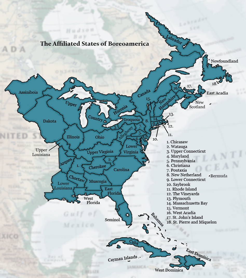
THE CHEROKEE NATION
ᏣᎳᎩᎯ ᎠᏰᎵ


Cherokee is a constitutional monarchy descended from an early chiefdom. Its territory more-or-less corresponds to the upper half of the basin of the Tanasi River. A lot of what I know about Cherokee comes from Carolina, the state that for a long time acted as its protector and suzerain. Much of the following is from Carolina's entry. I'll add more eventually.

Cherokee was already a chiefdom in the time of Spanish expeditions through the region. In the 16 and 1700s it became an English ally. As a way of asserting their overlordship, the English created the institution of Emperor of the Cherokee, conferring the title upon the chief Moytoy in London in 1730. The title lapsed several times, since at this point the Cherokee were not a modern state and their traditions of leadership were decentralized and informal. Subsequent "Emperors" were recognized, generally in Charleston or Keowee, a mixed Carolian-Cherokee town on the present-day border between the two states.

Throughout the late 18th and first part of the 19th century, Cherokee was a Carolian sphere of influence, with Carolina's Governor acting as "Father" of the alliance. Through the influence of Carolina and local English and Scots traders, a stable institution of Emperor emerged, with village chiefs electing a new Emperor upon the death of the incumbent.

Carolian cultural influence was also strong in Cherokee. More than the other southern Indian states, Cherokee adopted a slave system that was more similar to the Whites and drew less on indigenous traditions. Among Cherokee's neighbors, for example, the children of slaves were usually simply adopted. Not so in Cherokee.

During the two decades after 1800, the Cherokee developed their written language and used it to write a modern constitution. They came into direct conflict with Virginian settlers who were coming over the mountains into present-day Upper Virginia. Carolina, determined to safeguard its interests in Cherokee country, posted regulars to posts all over the area. England sent reinforcements. All-out war broke out between Cherokee and Virginia, and Carolina militia joined the fight. In the Treaty of Bath, Virginia sued for peace, recognition of its independence, and uninhibited access to its lands west of the mountains. In exchange Carolina got strong provisions recognizing its role as Cherokee’s protector. Any Virginian charged with a crime against a Cherokee, for example, could be tried in Carolina. This practice became so common in subsequent years that “Carolina court” in Virginian parlance came to mean anyone operating outside their jurisdiction. But the settlement brought peace and secured independence for the Cherokee and, ultimately, the other “civilized tribes” of the region, because the Bath provisions became the basis for similar treaties regarding the Muscogi, Choctaw, and Chicasaw nations.

A law in 1850 banned the importation of new slaves from other states into Cherokee, paving the way for the eventual end of slavery in the state.

The advent of the modern ASB in the 1860s and 70s enforced the principle of equality and brotherhood over suzerainty and fatherhood. The relationship between Carolina and Cherokee, like the other unequal partnerships within the ASB, gradually dissolved. Today the governor of Carolina is addressed as a Brother rather than Father of the Cherokee Nation. However, the English monarch continues to be honored as a Grandfather or Grandmother, a purely ceremonial nod to history. Cherokee, alone among the Indian states of the ASB, has kept its monarchy to the present day. In the 1790s the method of his election was made more formal, with the leader of each Cherokee town casting a vote. In 1848 the voting power passed from mayors to electors chosen by the free men of each district. This idiosyncratic "Electoral College" remains the basis for choosing the Emperor today.

FLAG
26841.png


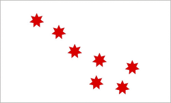
The flag seen here was probably first flown before 1700 and may be even older. Cherokee's War Flag, used by its state militia, has the same design but the colors are reversed.
 
Last edited:
I'd imagine that the border between English and Dutch would be very blurry along that straight line?

Yes and no. Now the border is quite clear for the main public language, the default language used in schools and the government and so forth. It's an old, established border that closely follows natural features, so the cultures on both sides are pretty well established. When you cross it, you can tell that you're in a place with a different primary language.

But as for the language of the population, yes, it's definitely fuzzier. The area around the City is as multilingual as it ever was, and in many places there are certainly more speakers of English than Dutch, though they are likely to use Dutch to communicate with their French or Spanish or Whatever speaking neighbors. Further north, you can see some cross-border spillover on the map if you really lean in and see. There tend to be more English speakers on the New Netherland side than the reverse, but there are also Dutch communities in the New England states. Bennington, Vermont, is majority Dutch speaking, which I had forgotten and have changed the map to show. Also there is a lot of bilingualism, mixed communities, mixed families, etc. on both sides.

Also relevant is that most of Long Island is actually part of New England. The center of the island is part of Connecticut. The border runs from Oyster Bay to Islip (both of which are on the Connecticut side). The far east end, the land around Peconic Bay, is part of Saybrook.
 
Mind if I see what is happening in Iroquoia and Huronia?

You mean contribute? I think so. For Iroquoia I'm in the middle of some reading about their "empire," because within the ASB they played a hegemonic role to some extent. The states with the most Iroquois influence were Poutaxia and Allegheny, which in the 18th century were close to direct dependencies of Iroquoia. Ohio and Huronia had some Iroquois influence as well. I'm doing the reading but have no immediate plans to write about Iroquoia, so you're welcome to contribute something if you want.

For Huronia, I've done a short page on Huronia that outlines its general history.
 
Turquoise Blue and I have been discussing two big topics via PM: the politics of Lower Louisiana and the (Francophone) Nationalist movement. I think I'll let her post that content, since it's her creation and not mine.

What I do have is some work on seven more constituent countries of the Pays-d'en-Haut - that is, the Upper Country. I have a lot more reading to do on the OTL history of Wisconsin, Minnesota, and Manitoba/Assiniboia, so please regard this as tentative. Only three Countries are left before the UC is fleshed out. Here is my slightly ugly reference map, which has undergone a few more adjustments to its internal borders.

upper_country_regions.png

-------------------

Milioqué Country: The city of Milioqué began as a trio of fur trading settlements along the lower stretch of the river. The settlements grew into market towns as commercial farming increased in the region. They finally merged into a single city in 1858. Agricultural bounty, the discovery of new metal deposits, and large numbers of immigrants from Germany fueled an industrial boom in the late nineteenth century; in fact, the city in 1900 had a German majority. Today French speakers outnumber German speakers, both in the city and in the Country as a whole, but the Teutonic element is strong and vibrant in the culture of Milioqué, evident in the brewing industry, in the series of annual Feste held on the wide green spaces that ring the city, and in cultural institutions such as the Civic Orchestra and the competitive choral scene.

Green Bay Country: The bay has been a trade hub since time immemorial, and the town at the head of the bay was one of the Upper Country's largest at the time of the earliest historical accounts from French sources. While the colonial powers concentrated their attention on the strategic points between the Lakes, Green Bay remained one of the main centers of the Indian population. No one tribe ever predominated in the diverse bay settlements, so the main language has been French since the mid-1700s. The rural parts of Green Bay Country are still largely Francophones of Indian or Mixed descent.

Agami: The Wild North was one of the last to be formally incorporated as a constituent country. It occupies the rugged, lake-spattered terrain north of Lake Superior, a land that has been valued for its furs but has little to attract a large population. Today Agami is known, when it is known at all, largely as a destination for outdoor sports. In particular Lake Nipigon, "the sixth Great Lake," is a draw for tourists. A large majority of the people of Agami speak Anishinaabe, with French as a widespread second language.

Thunder Bay Country: Thunder Bay attracted colonial attention from early times, but before 1850 nothing was there bigger than a few forts and fur posts. The town that today is the economic and political center of the area was founded by Jesuits as the Mission of the Immaculate Conception. Conception grew into a major port decades later after commercial wheat farming expanded in Assiniboia. The town continues to serve as a major grain shipping port today. Outside the capital, Thunder Bay Country is mostly heavy forest, like its neighbors around Lake Superior.

Mesabi: The Mesabi Iron Range was discovered in 1883 and immediately drew the attention of various mining companies and investors. English investors based in Assiniboia and Rupertia were well placed to take advantage of the mines, and more capital flowed in from New England and New Amsterdam. Workers flocked to the boomtowns from all over, but the largest groups came from the Anglo-American states, from Scotland, and from England, especially Cornwall. Local Anishinaabe were recruited in large numbers, as well. Therefore the two main languages today are English and Anishinaabe, an Anglophone country surrounded by Francophone neighbors. Mesabi lay outside the assumed borders of the Upper Country, but those borders were poorly defined. When the French-speaking Métis majority of Assiniboia overthrew the loyal Dominion government and declared themselves a republican state, Mesabi, one of the few parts of Assiniboia with an Anglophone majority, wanted to break away. After flirting with the idea of becoming a separate Dominion, the final decision was a request to join the Pays-d'en-Haut as an autonomous constituent country. This made sense in light of the economic links between the Great Lakes and Mesabi: by then most Mesabi iron ore was being shipped out via Lake Superior. Assiniboia put up a fight and mobilized its militia. The war was short, but it was the last time in the ASB's history that blood was shed in a conflict between states. Parliament finally arbitrated the issue and Mesabi became part of the Upper Country. It is still mining country today, and visitors will still note the region's Scottish and Cornish cultural influence.

Chequamegon Country: Chequamegon Bay and the Apostle Islands are the spiritual homeland of the Ojibwe people. In the middle of the 17th century, the bay drew refugees from many nations fleeing Iroquois expansion. French traders and missionaries followed. Somewhat removed from the wars and political movements of the lower Great Lakes, Chequamegon was known as a peaceful refuge for Upper Country culture by the late 18th century. It remains so today; many of the villages of Chequamegon have kept alive old Catholic and tribal traditions that have been lost elsewhere. The largest city, Oginaminsing, breaks this pattern. It is a bustling iron ore port at the far western end, a bilingual French and English city in a country that otherwise speaks Anishinaabe. In a situation parallel to Manitoulin Country, old Chequamegon remains the ceremonial capital, but Oginaminsing is the seat of government today.

The Massif: A space filling entity created by the Grand Assembly in 1890, the Massif is the largest constituent country in the Pays-d'en-Haut. It comprises the rugged Superior Massif as well as two larger cities: the capital Eau Claire lies on the plain south of the Massif, and the commercial center St. Paul is on the Mississippi. The Mississippi valley is the most populated part of the country. The towns along the river have close ties to the settlements on the other side in Dakota. They are largely French, with prominent minorities of Swedes, English, Anishinaabe, and Dakota.

This is honestly one of the best TL's I've ever seen. Keep up the AMAZING work :)

Thank you! :D:D
 
Last edited:
This map isn't particularly artistic, but I had been trying to determine exactly where are the boundaries of New Hampshire and the Acadias. For the most part, the Canada-NH border follows the British claim in the early 19th century. I recently learned of the Republic of Madawaska and am wondering if it can be incorporated as a New Hampshire exclave. It appears on the map as well.

(EDIT: I fixed the border between West Acadia and New Scotland. This change happened a few months ago; West Acadia is now a sizable state and not an empty backwater.) (EDIT2: I just changed Vermont's capital. Vermont actually has a system in which the capital must relocate to a different town every twenty years, to be chosen by the legislature. Currently it is in Bennington. This move largely applies to the legislature and the governor. Most permanent state executive offices are fixed in various towns. It's a really small state, and they make it work.)

Acadia and New Hampshire reference map.jpg
 
Last edited:

Gian

Banned
This map isn't particularly artistic, but I had been trying to determine exactly where are the boundaries of New Hampshire and the Acadias. For the most part, the Canada-NH border follows the British claim in the early 19th century. I recently learned of the Republic of Madawaska and am wondering if it can be incorporated as a New Hampshire exclave. It appears on the map as well.

You should have all the major cities highlighted as well.

Also, can we see the full map of the ASB?
 
This map isn't particularly artistic, but I had been trying to determine exactly where are the boundaries of New Hampshire and the Acadias. For the most part, the Canada-NH border follows the British claim in the early 19th century. I recently learned of the Republic of Madawaska and am wondering if it can be incorporated as a New Hampshire exclave. It appears on the map as well.

How about the Republic of Indian Stream as one too?
 
You should have all the major cities highlighted as well.

Also, can we see the full map of the ASB?

I went back added a few. More importantly, I fixed the Acadia-New Scotland border, considerably expanding West Acadia into the more populous southern part of OTL New Brunswick.

For a full map, I'm still using a version of my original. It's a little crude and has a few errors, especially the Acadia-NS border referenced above.

affiliated.png


How about the Republic of Indian Stream as one too?

That is so much smaller, and it's also attached to New Hampshire directly, so it wouldn't show up on a map like this. But when I flesh out NH, sure, we can say that both Indian Stream and Madawaska are conventionally still called "Republics," even though they function just like any other parts of New Hampshire. That would fit the spirit of the ASB: most of history's ephemeral settlement projects are memorialized in some way.
 
Lower Louisiana
Viva la Louisiane!

Lower Louisiana parties
Commonwealth/Richesse Commune: Left-wing populism. Affiliated with Socialists, but not that loyal to the federal party, TBH. Still reeling from Governor Emile Eustis's scandal-filled governorship in the 1990s that permanently damaged its popularity.
Union Nationale ("National Union"): Francophone nationalists. Tends right on economics, but gets some Anglo votes as "the only party that can defeat the reds" due to being the primary right-opposition to the Commonwealthers.
Liberal Party/Parti Libéral: Once Louisiana's dominant party, it has shrunk drastically and is now the third party. Often swallows its pride and back UN governments due to a common interest in preventing Commonwealth from ruining the state.
Reform Party/Parti réformiste: The conservatives in Louisiana. One of the more right-wing variations.
Farmers' League/Ligue des Fermiers: Rooted in the agrarian disaffection with the Liberal/Reform duopoly, it shrunk massively as Commonwealth surged. The League, a party deeply rooted in agrarianism, currently struggles to redefine itself for a new, urban, audience.

The Nature of Francophone Nationalism in the ASB
The roots of the movement sprang from several issues.
1: The increasing centralisation of the ASB and the growth of the Anglophone-dominated State.
2: Immigrants. This is mainly a Louisiana concern, though. Anglo (and Hispanic?) immigrants make locals anxious about their culture's future.
3: Influence. This is mainly a Canada concern. Canada used to be big in the ASB, but finds itself boxed out by Anglo countries those days.
4: Nostalgia. The Francophone nationalists harks back to the days of an united New France which "was strong and proud" (it's a myth, so it's not really historically accurate). Thus the common history as part of New France is often invoked.
5: Finally, geography. If you notice, the Francophone areas tend to be close to the border. There are probably a view that the ASB doesn't care about its borders (which given it sprang out of a loose confederation and states jealously guard their local interests, is probably right).

When and where did the nationalists emerge? Well, it depends, but I think the state level nationalists emerged in the 1970s. Remember the arrest of state governors by Lindon Jordan? That caused some anxiety with the people concerned about their culture. Lower Louisiana is pretty much utterly mixed those days (placage system never died out and instead intensified, average Lower Louisianan looks like a lightish-skinned black person (albeit the nationalist politicians tend to be white-ish)), so it isn't something to do with segregation. It's something to do with states' rights. Jordan violated it to defend something they agree with, but what if a future CM violate it for something they treasure? Thus nationalist concern. Now, the federal level nationalists? They first ran in 1992 and took defectors from formerly Soc-Prog-Whig-Dem people (like OTL Canada had with Bloc being established from defectors). This was probably because of some sort of Constitutional thing that got their hackles up.

It's goals are many and varied and depends on the region, but in general, it wants better funding to Francophone states (the flood in Lower Louisiana received sub-par relief from the Harman government according to them) and more influence for Francophone states. Plus the Canadien ones sometimes entertain the idea of secession.

The voters who support the Francophone nationalists are unsurprisingly Francophone. :p In Lower Louisiana, it tends to split the dominant mixed race voters with Commonwealth at the state level, but at the ASB level tend to dominate that demographic, and thus dominate the state. In Canada, it's mainly the rural areas (this is why the Greens are so urban there) and parts of the cities (basically think of OTL Parti Quebecois). At the federal level, it takes more prominence (think OTL Bloc) In Illinois, whatever nationalists there are tend to be concentrated in the mixed cities due to concern about Anglo immigrants silencing them.

Those who oppose the movement are Anglophones at both levels and cosmopolitan Francophones at the state level. The cosmopolitan Francophones who don't subscribe to nationalism may vote Commonwealth/Liberal/whatever at the state level, but at the federal, think that their state deserves more of a voice, so they turn to the only party guaranteed to give them that.

What changes did the nationalists achieve? Well, it has successfully made the ASB officialise the languages (English, Dutch, French, Spanish, whatever are now official languages), made multilingualism an official national policy (albeit not one fully followed through) and guaranteed their right to speak their native language in Parliament.

At a state level, the Nats has invested greatly in the French language in both Lower Louisiana and Canada. In the less nationalist Francophone areas, it has less influence, but it has successfully made learning of French compulsory instead of assumed universal.

Upper Louisiana is mostly French-speaking and on the border and so has a strong nationalist movement, but however it is markedly less powerful than in Lower Louisiana. Upper Louisiana is perhaps more "Americanized" and less open to nationalism than Lower Louisiana. Nevertheless, they do have a very strong presence.

The Acadias (aka the Maritimes) has a strong Francophone presence, but the nationalist movement there fizzled out due to the politics of the states being unfavorable to them and their Nationalist selling point receiving few supporters due to Acadia's historical dislike of Canada.

Huronia is also largely Francophone, but its culture is quite cosmopolitan. Toronto has a Dutch background; though its most prominent language is French, its culture feels more like New Amsterdam than Montreal. In the state, the nationalists are quite irrelevant.

Haiti is far away from the rest of the Francophone states but culturally has close ties to Lower Louisiana, and due to Lower Louisiana's somewhat unique racial status, the nationalists there decided to set up a branch in Haiti. However, Haiti had a history of rebelling from France, and so the nationalists there find that they have to redesign their appeal somewhat creatively in order to appeal to Haitians.

The Upper Country has more speakers of French than any other language. The states along the ASB's western border have many speakers as well, certainly in the cities. It is seen by many Nationalists as the "unifying state" of the two traditions of Francophone Nationalism as it united New France. In this state, the Mississippi and St. Laurent traditions heavily collaborate and mix together to create an unique, third, tradition.
 
So, after talking with the great False Dmitri himself, I'd like to "announce" (I say that loosely) that I'm now a "contributor" (also said loosely, but you know what I mean) to the TL. I'll hopefully be working with him and TB to work more on this in the future. Yay! :D
 
Some additional blurbs on Vermont

Government (confirmed with TB):

The state's commitment to republican egalitarianism is reflected in its constitutional structure. Care is taken to limit power at every level. Legislators are elected to one-year terms, and the President has a term of only two years. The power of the executive is weaker than in a typical presidential system, and the House of Representatives possesses considerable checks on the president's power. The state itself has to contend with the strong township governments typical of New England. The towns have surrendered some of their power to the state over the years, but retain considerable home rule rights. The independence of the towns led to the most singular feature of Vermont government, its "wandering capital." Every twenty years, the House of Representatives is required to vote on a new location for the capital. The President, Council, Supreme Court, and House of Representatives are then required to relocate to the new town at the start of the next legislative session. Government agencies and offices generally do not move, and the result is that the state bureaucracy is scattered among various towns across Vermont. The republic's small size and lack of an urban center make this possible.

Religious history:

Vermont is known as the birthplace of the Mormon religion. The revelations that form the basis of the faith occurred here in some of the valley towns near the Connecticut, and it was here and in northern New Hampshire where the original Mormon congregations were founded among the hardy, mobile, frontier-dwelling Yankee population. The scattered congregations were eventually drawn together to a new site in Upper Connecticut. Lake Erie was briefly the center of the religion until persecution led the community to relocate to the Missouri valley in Upper Louisiana and the surrounding area.

State anthem:


Vermont's state anthem was written in the 1820s by Massachusetts poet John Greenleaf Whittier. It commemorates Vermonters fighting in the Wars of Independence. Intended for a Massachusetts audience, the poem quickly became popular in Vermont for obvious reasons.

https://youtu.be/Y4KcJTP8nW8
 
A piece on how the ASB got independence. Ben and I spent a while talking about ideas for this, and this is what we finally settled on:

The Four Phases of Boreoamerican Federalization

Phase One: A Council of Councils

The predecessors to the ASB have existed for centuries, most being originally formed solely for the purpose of reaching out from the colonies to the natives. The Covenant Chain was the first alliance for this specific reason, and tied together the newly formed Dutch colony of New Netherland with the Iroquois tribes. It wasn’t called the Covenant Chain until the leader of the Iroquois converted to Christianity in 1686, but the semi-frequent series of meetings between the two cultures would be carried forward as main ideals of the ASB. As time went on, the French did the same with the ethnically-Ojibwe Three Fires Confederation. These native states were not regarded as colonies of the European powers, but they were instead seen as potential allies and possible partners in trade. This became a popular ideology in the north, eventually affecting the settlement of Labrador and what became the middle regions of the ASB. The Children of Onontio was founded in 1665 as a loose organization, where the government of the Canada colony would meet with the three leaders of the Ojibwe Confederation on a yearly basis. Later on, it would represent autonomy in the Canadian colony and eventually transitioned the Upper Country through admission into the ASB.

Phase Two: Congresses of North America

Eventually, things transitioned from somewhat-organized meetings into fully scheduled ambassadorial congresses. The switch into this phase was mostly marked by revolts and wars of independence in the Americas, which caused autonomy to be achieved by many North American colonies. In the 1730’s, the Congress for the West Indies was founded after a large slave revolt, led by the bastard son of famous former slave William Matthews. It was originally meant to be a cooperation between free blacks and other free Cubans, but grew to be an alliance between the other Spanish colonies as well as French Louisiana. This marked eventual self-government, which began to make the European powers quite angry. However, after the Wars of Independence in the 1760’s, there was not much the Europeans could do about places like Maryland and North New England. While America was severely divided, the organization known as the Anglo-American Congress brought relations back together with recently independent English states with their surviving colonies. While the main leadership of England wasn’t too happy about this development, there was ultimately nothing they could do. The alliance between the English-speaking places in North America was a net gain for them, and they could afford to sacrifice a bit of their pride for a lot of stability. In the beginning, the Anglo-American Congress (or AAC) wasn’t too heavily enforced, but meetings grew to become more stable and federalized later on in the eighteenth century.

Phase Three: One Congress of the Nations

The Anglo-American Congress began to solidify, becoming a true series of meetings between all English-speaking areas of America. Eventually, the entity itself had a strong enough congress to present itself to other cultures and ethnicities, besides being solely English. In 1792, the Anglo-American Congress decided to reach out a hand to the Covenant Chain, to form a better alliance across the entire Atlantic Coast. This duel “alliance-alliance” became known as the Anglo-Dutch Federation, or the League of the Atlantic. The government of this was arguably one of the most convoluted of all time. There were two houses that met bi-annually in Pennsylvania, one for the Dutch and one for the English. The natives were somewhat divided up between the two houses, although a subsection of the Dutch house was reserved for Iroquois and even Susquehanna delegates. The two houses met to discuss certain issues going on in the colonies, but the natives had the power to veto any proposal with a unilateral vote (at least for the Dutch house, for the English it was a much harder process) as to not let the Europeans get too voluntarily powerful. Colonies still belonging to England had their own section (the Dutch didn’t need this, as the entirety of New Netherland was still a colony, not just parts of it), with “reduced membership”. “Ambassadors” from other colonies were allowed time to speak at each of the meetings (but didn’t have any power to vote or provide more than one proposal), which could normally last up to two days. The Anglo-Dutch Federation kept up good relations with the Children of Onontio and the Congress for the West Indies, but had secret desires for expansion and federalization throughout North America. Things were going well, and by the 1830’s the government of the Anglo-Dutch Federation had mostly gotten rid of the Covenant Chain and the Anglo-American Congress.

Phase Four: Foundation of Parliament

The expansion of the Anglo-Dutch Federation into North America was something came up at nearly every meeting after 1820, and they were just waiting for the opportunity of expansion to arise. While it wasn’t a unified entity, they were planning for it to eventually federalize (at least the non-colonial parts of it, anyway). The fact that they existed already stirred a reaction in the people of Canada, who desired to join such a federation to a degree. However, the Children of Onontio were all but ignored by France, who had recently decided to disregard the natives and focus on bare expansion. This proved to be a bad choice, as the North Onontio Rebellion raged on for years in the 1830’s. France provided enough military response to keep the war going, but not enough to crush it. The fact that they desired colonial expansion in other regions forced them to not focus their full forces on Canada, which led to their downfall in the colony. The Anglo-Dutch Federation extended their hand out to Onontio (then comprised of what would become Ohio, Illinois, Canada, Huronia, and the Upper Country), asking them to join their alliance. Canada asked two things of them; a name change to better suit their French-native origin, and a more federalized government. They complied, and the alliance was changed to the “Affiliated States of Boreoamerica” on April 1st, 1841. It began the path of federalization of the ASB, making Canada one of the founding members of the affiliation. The Iroquois would agree to subsume to ASB rule next, followed by the south in the 1850’s. For France, the loss of Canada was heartbreaking, as it was one of their first colonies. They went on a colonization spree, forming the colonies of Terresud (OTL South Australia) and Patagonie (OTL Southern Argentina). This also led them to try to hold Louisiana for as long as possible, which meant keeping autonomy from them for as long as possible. France tried to attempt things that England never would have, including breaking up Louisiana’s membership in the Congress for the West Indies. This plan worked spectacularly, although it plunged the economies of the Spanish Caribbean colonies significantly. East Dominica fell from France in a major revolt known as the “Ayiti Revolution”, but ended up having next to no trade partners. Cuba and West Dominica were still a part of Spain, but that didn’t last. Neither did the French hold on Louisiana. The ASB ended up extending their hand to these Caribbean nations, with them joining around 1870. The centralized Parliament was formed around then as well, which led to the current present incarnation of Boreoamerica we know today.
 
Top