Affiliated States of Boreoamerica thread

St. Pierre and Miquelon
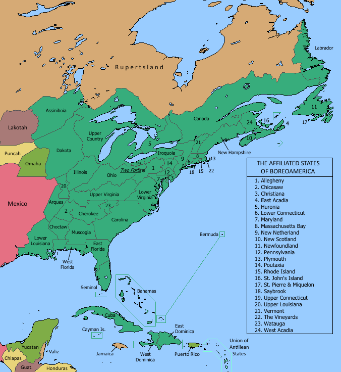
  • I've done a fair amount of rebooting and retconning over the years. I don't anticipate doing much more. But St Pierre had only a half-assed little blurb that obscured the uniquness of the islands, and that had to be fixed. What follows is more a geopolitical than a cultural history. I want to slend some time exploring the island's culture... but I'm planning a trip there in the nearish future. I know I'll write a lot more then. For now, we can think about what the islands' history reveals about the development of the ASB and its relationship to Europe.

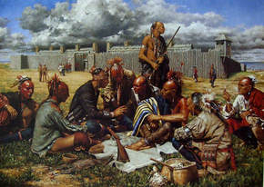
    I’d like to set some context first. As early as the 15th century the islands of St. Pierre and Miquelon were an important base for fishermen from Normandy, Brittany, and the Basque Country. In the wars of the 18th century they passed back and forth between France and England. England repeatedly ordered the French settlers to be deported, but French fishing boats continued to frequent the islands. The conflicts over St. Pierre were part of the wider conflict over who controlled Newfoundland. In the treaty of 1808, England and the French Empire confirmed what was basically the status quo already: that Newfoundland would belong to England alone; that France would have exclusive fishing rights along part of the coast, but no territorial rights; and that France would possess the little islands so that it would have a toehold of land in the fishery.

    Napoleonic France came to an end in 1832 after the death of Napoleon II. The young emperor was childless but not heirless and had taken pains to set up an orderly succession; nevertheless, republican forces saw their opportunity. The revolution was bloody but short. In North America, the four parts of the Kingdom of New France also took the opportunity to shake off French rule. Once news of the revolution arrived, independence was declared in Canada, Louisiana, Illinois, and Saint-Domingue. The only northern colonies that France managed to hold were Acadia, which was not part of the Kingdom of New France, and St. Pierre and Miquelon.

    Years of dispute over the islands and the fisheries ensued between France and the new government of Canada. Canada considered itself the rightful successor to France and wanted to assume its role in the islands, the French Shore of Newfoundland, and Labrador. The dispute played out in the Congress of the Nations, which had emerged as the main deliberative body for all the Boreoamerican states. It remained unsolved in 1849 when Acadia, the last major French colony on the continent, declared its independence. The event sparked something of a crisis in Congress, since many delegates believed that some French presence was necessary to the continental balance of power. This faction was placated by a compromise that recognized St. Pierre and the French Shore rights as the property of the French Republic, not Canada. As compensation, Canada inherited France’s rights in Labrador.

    St. Pierre’s status as the last French colony had economic and political consequences. The cod fishery was still valuable, and France was happy to keep its access to it even if it had lost its territorial colonies. And importantly for the ASB, the deal meant that a French delegation remained in Congress and would continue to have a voice in confederal affairs.

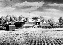
    During this period, the population of the islands grew. Most of the newcomers came from the same regions that had supplied the earliest arrivals: Normandy, Brittany, and the French Basque Country. Smaller numbers of people arrived from nearby states; they included Newfoundlanders, Acadians, and Gaelic-speaking New Scots, resulting in a lively and unusual cultural mix. St. Pierre grew into a sizable town and received a proper government.

    The evolving political structure of the ASB was giving more and more power to the elected Parliament. Congress, whose members were appointed by the state governments, including the French government of St. Pierre, faded into the background. The Parliament of 1868 is considered the first of the modern era, and in 1899 Congress was abolished as a legislative body. During these years the confederal government assumed control over member states’ military and foreign policy. France’s voice in the Congress became increasingly irrelevant.

    In the late 19th century there were still some questions over how much right the former colonial powers had in their loyal Boreoamerican dominions. Newfoundland and southern New England were still in a sense part of the English Empire, while Christiana still had ties to Sweden and, through personal union, to the Russian Empire. France’s sovereignty over St. Pierre was seen in the same light. Therefore, the great European war that erupted in the early 20th century presented the very real danger that the ASB could become a theater of European conflict. The confederation had been founded precisely to prevent this sort of thing. Parliament, under the control of the centralizing branch of the Whig Party, passed strongly worded resolutions that banned European warships from ASB waters and built up the navy and coastal defenses to enforce the ban. The ASB ended up joining the war anyway, but the ban was upheld in subsequent treaties.

    This meant that while St. Pierre remained part of the French Republic in name, in fact it was an integral part of the ASB. The islands had not had representation in Parliament before due to their very small population, never more than 10,000. Now they sought a status equal to the other states. They were recognized as a state in 1925. France had to begrudgingly accept its reduced role in the islands and enacted laws that loosened ties to St. Pierre and created an autonomous state government.

    St. Pierre and Miquelon officially remained a French overseas territory, but France’s power was strictly circumscribed by a body of laws and treaties. French fishing fleets continued to come to the islands and to Newfoundland, but boats from the rest of the ASB were free to fish as well. French law applied somewhat, but acts of the ASB’s parliament took precedence, as St. Pierre was first and foremost an ASB state. The islanders today, though loyal citizens of the confederation, are still proud of the symbolic and economic links that they have with France. Their culture is more closely tied to Europe than the rest of Franco-America, and the state is a reminder of the legacy of the French overseas empire.
     
    Upper Connecticut
  • Upper Connecticut

    In the 1640s Connecticut bought much of the land granted to Saybrook colony, including its claim to vast lands west of the Alleghenies. For more than a century it made no attempt to back up this claim. But after 1770, when many English colonies relinquished their more extravagant western claims in the interest of continental harmony, small, ambitious Connecticut stood firm. The province refused to give up its titles and began actively sponsoring settlement along the southern shore of Lake Erie.

    The settlers who moved out there were a hardy bunch of no-nonsense Connecticuters. They had to be - they were heading into a region contested among several empires and Indian factions, where warfare for land, fur or revenge remained the norm. The newcomers drew up articles for their government and defense. Connecticut could only hope that its far-flung colonists would be able to wait out the storm.

    They did not wait. After a rowdy congress in Laconia (Painesville), the Lake Erie settlers audaciously decided that their situation prevented any real links being maintained with Connecticut. They would pursue a course free from control by Connecticut or the king, and become an independent power in the Ohio Country. They maintained some sentimental links with the old colony, as reflected in the name they eventually chose: The Free State of Upper Connecticut.

    Yankees continued to immigrate to Upper Connecticut. So did a number of Indians of various tribes. The UC welcomed their settlements on the Upper Cuyahoga as a way to help secure the state's southwestern flank.

    Upper Connecticut eventually was accepted by its neighbors and won an equal place alongside the colonies and major Indian powers. The hardworking pioneering spirit of the early days can still be seen in the state's heavy industries.

    Map of major UC settlements around 1790

    Upper Connecticut 1780s flat.png
     
    Christiana
  • Christiana

    This map shows the modern situation in Christiana, more or less. Selected cities with particular historical importance are shown.

    When the Dutch took over New Sweden, it was already probably stronger than in OTL. Britain ruled it next, detaching it from New Netherland (unlike OTL, when Britain gained the whole of NN). New Sweden was essentially made a dependency of the new Pennsylvania colony.

    Under Penn family rule, the Swedes continued to exist as a separate community. In some ways their status was comparable to Native American groups. They were forced to relinquish the land around the original Upland, seat of their governing court, but built a new one east of the Delaware River. A lot of the best land along the river was taken over by Quaker and other English proprietors.

    In some still-vague way, the Swedish settlers were able to maintain some kind of link with the home country during the 18th century and continue to attract immigrants. Later, for also-vague reasons, New Sweden had some kind of political revival. Large numbers of immigrants settled in the empty eastern part. The new political order incorporated the British and the Swedes, as well as the children of Lenape-Swedish marriages. At this time the Swedish monarchy may have had some of its rights restored there, though it was never fully re-colonized.

    That's why today, the best and most populous parts of Christiana are still English-speaking, while the large but sparsely populated eastern lobe is largely Swedish. Small Dutch settlements persist in places where New Netherland had made land grants in the 17th century; NN's closeness to Christiana helped the small communities there maintain the Dutch language. The Lenape were consistent allies of the Swedes and the groups intermarried widely; in the north the Lenape language predominates, in the south, Swedish. Land that the Swedish King granted to German settlers around the town of Gottorp stopped speaking German long ago. So did the other Germans who were important in the settlement of southwestern Christiana.

    Christiana has two capitals; Christiana itself is the executive, and Upland continues to be the legislative. The working flag right now mixes Sweden's cross with the Penn coat of arms. The un-Swedish spelling is a compromise between English and Swedish speakers: the name would acknowledge the Swedish heritage but use a Latin/English official spelling.

    Some equivalents:
    Nya Vasa = Camden
    Colby = Cherry Hill (originally a Quaker settlement, a rare case of an English town later becoming mostly Swedish/Lenape)
    Upland = Woodbury
    Atlantenstad = Atlantic City - I should note that I don't plan on this being the final name. Some kind of resort town grew up at this spot, but it probably has a less convergent name.

    Language map of Christiana

    Christiana modern languages.png
     
    Vermont
  • Very general overview map of Vermont.

    In the world of the ASB, Vermont represents an area where the colony of New Hampshire illegally gave grants to settle in Dutch territory to some of its citizens and to some bands of Abenaki.[*1] In a classic divergence of interests, the British government refused to support the settlers, who spent decades fighting off Dutch officials on their own in a slow-paced conflict that was a constant threat to Anglo-Dutch relations.

    In the 1760s, the conflict came to a head. Britain confirmed its recognition of Dutch authority in the land west of the Connecticut River, in effect disowning the Vermonters. The settlers formed a militia, the Green Mountain Boys, and then a republican government. This was probably a bluff meant to force Britain to re-assess the situation, but it drew the attention of French Canada. The French welcomed any disunity among their English rivals and were at the same moment stirring up trouble between Virginians and Pennsylvanians in the Ohio country.[*2] The Canadian governor extended recognition and friendship to the new republic, and after that there was really no going back.

    Vermont is often compared with Upper Connecticut and Watauga, all small English-speaking states that began as independent settlement projects without support from the mother country. Its tradition of stubborn self-reliance is considered the "north pole" of the quintessence of New English culture; the "south pole" is represented by Martha's Vineyard with its his history of tolerance, sensible compromise, and a nautical tradition.

    Today Vermont, like the rest of New England, is mostly English-speaking; but the southwest around Bennington has become largely Dutch, while the northern borderland has many French speakers from Canada. Memfremagog is about 50%-50% French and English. The Abenaki language has not fared particularly well here, since they intermarried with the ENglish and their children largely abandoned the Indian language; but some important pockets remain. St. Johnsbury in particular is known for its Abenaki culture; most road signs and shops in town are bilingual.

    [*1] In the world of the ASB, it would be madness for settlers to begin a project without bringing along some friendly Indians. Without them they couldn't hope to defend a wide area by themselves, and the Indians' family connections in nearby villages would help them smooth over conflicts with their neighbors.
    [*2] Another feature of the ASB is the intense rivalry among the English-speaking colonies. Today, descendants of those colonists identify as different ethnic groups, usually called "stocks," the most prominent of which are Yankee, Pennamite, Virginian, and Carolian. Those identities to an English speaker are at least as important as the distinctions between Canadiens, Adadiens, and Métis to a French speaker.

    ps - Vermont is the most obvious clue that the ASB is not a strict alternate history project. It is highly convergent in a world that began to diverge from ours in the early 17th century.

    vermont FLAT.png
     
    Last edited:
    Dominion of New England
  • The first new map in a long time - The Dominion of New England:

    "Dominion New England," also called "Royalist New England" or "Tory New England," descends from those colonies that did not reject the English monarchy in the late 18th century. Its unification, and the treaties that bound it in friendship to "Republican New Enlgand," are a part of the ASB's origin story.

    The Dominion does not encompass everything that is considered New England, which includes Massachusetts Bay, New Hampshire, and Vermont. Meanwhile, "Greater New England" includes all parts of North America heavily settled by Yankees, including St. John's Island and Upper Connecticut on Lake Erie, along with smaller traditional Yankee communities throughout the North.

    The lozenge symbol on the map is the official logo of the country; there is also a coat of arms and flag used to represent New England.

    ... This does clarify further what the ASB is. Monarchy is still around for some states, though others had some kind of revolution. There are tighter federations within the broader Confederation, which probably implies some other interlocking structures as well (not unlike Schengen, the EU, the Eurozone, et cetera).

    dominion flattened.png
     
    Last edited:
    Illinois
  • Something I wrote months ago but did not share here:

    405496384.jpg


    ILLINOIS
    ORIGINS OF THE ETHNIC ILLINOIS

    The Illinois are a hybrid people. They are considered one of the Métis peoples of North America, because their heritage is both French and indigenous; yet they are a different ethnic group from the Métis proper, or Canadian Métis. The language of the Illinois is French, but their dialect contains words and phrases from the language of the ancestral Illinois, or Inoca.

    The original Inoca confederacy united several Algonquian tribes. In the first half of the 1600s, it was the dominant power in the present-day states of Illinois, Upper Louisiana, and Arques, as well as the southeastern part of the Upper Country. A series of wars between the Iroquois and their neighbors brought many refugees into this region; the refugees created new alliances that threatened the rule of the Inoca. By the 1660s the confederation was still powerful, but its influence extended no further than the borders of the present-day state, and this influence was diminishing. During this time, the first French traders began to move through the Illinois country.

    French habitants began to build farming villages around 1700, with the first appearing next to the existing Inoca villages of Cahokia and Kaskaskia. By then, the confederation was facing serious threats from Iroquois raids, ongoing friction with newcomers to the region, and diseases brought by the French themselves. With their power and their numbers declining, the Illinois had to rely more on their alliance with the French. Illinois villages that did not have adjoining French forts shrank or disappeared. The core of the confederacy shifted to the line of towns in the Mississippi Bottom, the ribbon of flat, fertile soil to the east of the river. The modern Illinois people came from the mixed settlements that took shape there.

    Both the Illinois Indians and the French habitants contributed to the emerging culture. The French brought their language and the Catholic religion. The Indians brought styles of clothing and housing suited to life in the bottom lands and up on the prairie. A form of communal land ownership characterized the settlements, a practice known to the French and acceptable to the Indians. Such Illinois cultural elements as food, music, and dance styles truly were new combinations not seen elsewhere in America or Europe.

    By the second half of the eighteenth century, the lines between French and Inoca were already blurring. A great many habitants had family from both cultures. Local leaders had dual roles, as French colonial administrators and confederation chiefs. "Les Illinois" came to be recognized as a unique, mixed-blood, French-speaking ethnic group. Ethnic Illinois began to migrate across the Mississippi River and elsewhere, bringing a sense of Illinois identity with them.

    FROM CONFEDERATION TO STATE

    In the 17th and 18th centuries, the French administration officially called Illinois Haute-Louisiane, treating it as a northern extension of their colony in Louisiana. But Illinois had broad de facto autonomy. For one thing, there was the sheer distance between Illinois and the centers of French power in New Orleans and Quebec. In addition, local administrators' roles were merging with the roles of confederation chiefs, encouraging them to have a "national" outlook often different from the colonial French point of view. Finally, Illinois was able to exploit rivalry between Louisiana and Canada to win more local control over its affairs.

    In the 1760s France built St. Louis on the other side of the Mississippi River to be a new center of trade and administration, one that would be more subservient to colonial rule than the precocious Illinois. This served to divide Haute-Louisiane in two: a nearly independent "Illinois" east of the river, and a much more reliable colony of "Upper Louisiana" to the west. Subsequent French settlement focused on Upper Louisiana. Other settlements east of the river, most notably Peoria, became dominated by Franco-Illinois and allied Indians from other groups such as the Potawatomi.

    The foundations for the modern state of Illinois were laid in the early 19th century. Neighboring peoples acknowledged Illinois's borders and its independence from both Upper Louisiana and the Upper Country. A great meeting began to occur in Peoria that brought together administrators, leaders of Illinois habitants, allied village chiefs, and representatives of English settlers. This meeting evolved into a government. In 1839, Peoria became the sole capital of the state when most functions of government ceased in Kaskaskia (the French center) and Vandalia (the English center).

    ETHNICITY AND LANGUAGE

    The ethnic Illinois were the foundation of the state, but from early times it incorporated others of different language and ethnic backgrounds. The Potawatomi of the upper Illinois River valley were effectively part of the state by 1800 or so. A short time later, growing settlements of Virginian English speakers in the prairies and hills above Kaskaskia became allies, fully integrating into the state in 1839. The Sauk-Fox confederacy, centered north and west of Peoria, was incorporated shortly after that. Further diversity in the early years came from additional French settlers (mostly people of Canadian background coming from the Upper Country and Upper Louisiana), German immigrants, Pennsylvanian and Virginian land speculators, and freed and runaway slaves.

    French has always been the only province-wide official language. English, Meskwaki, Potawatomi, and German have deep roots in Illinois and are spoken in some communities. Old Illinois, or Inoca, is no longer the language of the ethnic Illinois. The same language is spoken by the Wea and Miami people in the state of Ohio, so some speakers live inside the borders of Illinois. It is still used in personal names, place names, and inscriptions. As stated, a number of terms have been borrowed into the local French, such as nal, "cicada," and aquime, "chief", which today can mean "sir", "respected elder", "teacher", "member of a local council", and so forth.

    Do you mind making a map for Maryland in the ASB?

    This was actually on my mind for the next one. Maryland's borders are swelled just a little in all directions. In OTL Maryland Colony lost just about every land dispute it ever had; in TTL things went slightly better. The far west is more than just a triangle barely hanging on, for example.

    Hey! :D

    So the ASB is back? Cool!

    How do state governments function? Is there a wide variety, with some having parliamentarism and others presidentialism, with even others having special ways?

    Why, it never went anywhere! Yes, there is naturally huge variation in the state governments. To the point where Southern New England, it appears, has kept the monarchy while most other colonies have not. And I am next to certain that one or more states recognize the Jacobite claimant. Massachusetts and most other ex-English colonies have presidential systems, while southern New England, I am sure, has adopted a Westminster-style parliament. I want to read more about how modern Native American polities governed themselves - particularly the Cherokee pre-Removal and the Haudenosaunee today; because these will form the basis for their corresponding governments in the ASB.

    Sweet, good to see this back!

    I did have a question over your "English Heritage" map a bit upthread. It reads that the Scots-Irish generally went to the Piedmont region, in the foothills. Would this include Lowland Scots? These colonists were/are a totally different animal than the Highlanders who spoke Gaelic, instead of Lallans or Scottish English like the Lowlanders did. I'd personally bet they collocated in the Piedmont given their closer ties to the Ulstermen who preceded the Scots-Irish.

    The short answer is yes. The longer answer is that some of that needs to be re-worked as I develop Nova Scotia and the Acadias. I have it filled up with Yankees and Highlanders, per OTL. However, almost everywhere I have been using the term "English" over "British" because part of the back story in my mind is that the Act of Union never occurred and Britain came out of the Civil Wars weaker than in OTL; that partly explains the lack of British and Anglo-American dominance. I think that Nova Sotia will end up as a true Scottish colony, and this will change some of what I've written, both about the ethnic groups (the "stocks") and about the political history of Acadia. This is the reason that nothing on the English stocks has yet made it into the official canon (which lives on my website, http://karnell.weebly.com/the-asb.html).

    But yeah, some Scots would still be immigrating to the English colonies, and many Yankees would still move into Nova Scotia, even in this scenario.
     
    Last edited:
    Quotes
  • Here's some quotes from the Chief Ministers...

    "This country, with its institutions, belongs to the people who inhabit it. Whenever they shall grow weary of the existing government, they can exercise their constitutional right of amending it."
    - Armand Linville, speaking of the state of the country after the Constitutional Revolution.

    "Boreoamerica is, and always will be, free. The average voter has knowledge enough to guide the nation."
    - Joseph-Adolphe Chapleau, talking of the virtues of democracy. This shows how different even conservative Democrats are to the aristocratic establishment that ruled the country before the Constitutional Revolution.

    "We Aboriginals have less influence than we deserve. One of the great things about this country is that it is flexible enough to allow us what we deserve."
    - William Walker talking of the Aboriginal influence on the nation.

    "As long as this country denies the democratic right to vote to the lowest of all Boreoamericans, then we cannot look at ourselves and say we are truly better than we were thirty years ago."
    - James A. Garfield, defending his Electoral Reform Bill. This statement generated an outcry from Democrats and even from some of his Whigs.

    "I am the man who is marching to his death."
    - Ely S. Parker, talking of the Whigs' electoral chances in the 1887 general election.

    "It is said that it is far more difficult to hold and maintain leadership that it is to attain it. Success is a ruthless competitor for it flatters and nourishes our weaknesses and lulls us into complacency."
    -
    Samuel Tylden, on his 1887 landslide victory against the Whigs.

    "Sensible and responsible workers do not want to vote. The relative positions to be assumed by the different classes in the system of our civilization were assigned long ago by a higher intelligence than ours."
    - Steven Cleveland, speaking of the growth of the states that allow the working-class to vote. This shows the increasingly conservativeness of the Democratic Party.

    "After we have calmly stood by and allowed unions to grow strong, we should not be asked to make them able to threat this country."
    - John Carlisle, speaking of the growth of trade unions. His perspective of trade unions becoming a potential threat to the country shows the middle-class dominance of the Democratic Party.

    “Oh, Mr. President, do not let so great an achievement suffer from any taint of illegitimacy."
    - Pascal Chastain, speaking of his successful referendum to the President who threatened to contest it on the basis that Linville and the rest of the Founding Fathers did not intend it to be used that way.

    "Let them look to the past, but let them also look to the future; let them look to the land of their ancestors, but let them look also to the land of their children."
    - Wilfrid Laurier, speaking of the importance of thinking of both the future and the past. He was referring to the other parties' tendency to look to the past for all the answers.

    "It is impossible to defeat an ignorant man in argument."
    - Dougal McAdoo, speaking of his declining to enter in a debate with Marion La Follette, his progressive competitor for the Whig leadership. McAdoo's campaign split the party in two.

    "In the great fulfillment we must have a citizenship less concerned about what the government can do for it and more anxious about what it can do for the nation."
    - Gamaliel Harding, speaking of the Democratic perspective on the people's relationship to the government. He was contrasting it with what he considered the Socialist perspective to be.

    "To destroy a standing crop goes against the soundest instincts of human nature."
    - Henri Voclain, speaking of the economy and his "status quo" approach to the Desolation. Floyd Olson would later reply with "The standing crop has all withered, much to his ignorance."

    "I intend to do what little one man can do to awaken the public conscience, and in the meantime I am not frightened by your menaces."
    - Urban Stendahl in 1918, making a statement against the Sedition Act. He was later arrested, but was re-elected in his seat's by-election.
     
    Lower Louisiana
  • Viva la Louisiane!

    Lower Louisiana parties
    Commonwealth/Richesse Commune: Left-wing populism. Affiliated with Socialists, but not that loyal to the federal party, TBH. Still reeling from Governor Emile Eustis's scandal-filled governorship in the 1990s that permanently damaged its popularity.
    Union Nationale ("National Union"): Francophone nationalists. Tends right on economics, but gets some Anglo votes as "the only party that can defeat the reds" due to being the primary right-opposition to the Commonwealthers.
    Liberal Party/Parti Libéral: Once Louisiana's dominant party, it has shrunk drastically and is now the third party. Often swallows its pride and back UN governments due to a common interest in preventing Commonwealth from ruining the state.
    Reform Party/Parti réformiste: The conservatives in Louisiana. One of the more right-wing variations.
    Farmers' League/Ligue des Fermiers: Rooted in the agrarian disaffection with the Liberal/Reform duopoly, it shrunk massively as Commonwealth surged. The League, a party deeply rooted in agrarianism, currently struggles to redefine itself for a new, urban, audience.

    The Nature of Francophone Nationalism in the ASB
    The roots of the movement sprang from several issues.
    1: The increasing centralisation of the ASB and the growth of the Anglophone-dominated State.
    2: Immigrants. This is mainly a Louisiana concern, though. Anglo (and Hispanic?) immigrants make locals anxious about their culture's future.
    3: Influence. This is mainly a Canada concern. Canada used to be big in the ASB, but finds itself boxed out by Anglo countries those days.
    4: Nostalgia. The Francophone nationalists harks back to the days of an united New France which "was strong and proud" (it's a myth, so it's not really historically accurate). Thus the common history as part of New France is often invoked.
    5: Finally, geography. If you notice, the Francophone areas tend to be close to the border. There are probably a view that the ASB doesn't care about its borders (which given it sprang out of a loose confederation and states jealously guard their local interests, is probably right).

    When and where did the nationalists emerge? Well, it depends, but I think the state level nationalists emerged in the 1970s. Remember the arrest of state governors by Lindon Jordan? That caused some anxiety with the people concerned about their culture. Lower Louisiana is pretty much utterly mixed those days (placage system never died out and instead intensified, average Lower Louisianan looks like a lightish-skinned black person (albeit the nationalist politicians tend to be white-ish)), so it isn't something to do with segregation. It's something to do with states' rights. Jordan violated it to defend something they agree with, but what if a future CM violate it for something they treasure? Thus nationalist concern. Now, the federal level nationalists? They first ran in 1992 and took defectors from formerly Soc-Prog-Whig-Dem people (like OTL Canada had with Bloc being established from defectors). This was probably because of some sort of Constitutional thing that got their hackles up.

    It's goals are many and varied and depends on the region, but in general, it wants better funding to Francophone states (the flood in Lower Louisiana received sub-par relief from the Harman government according to them) and more influence for Francophone states. Plus the Canadien ones sometimes entertain the idea of secession.

    The voters who support the Francophone nationalists are unsurprisingly Francophone. :p In Lower Louisiana, it tends to split the dominant mixed race voters with Commonwealth at the state level, but at the ASB level tend to dominate that demographic, and thus dominate the state. In Canada, it's mainly the rural areas (this is why the Greens are so urban there) and parts of the cities (basically think of OTL Parti Quebecois). At the federal level, it takes more prominence (think OTL Bloc) In Illinois, whatever nationalists there are tend to be concentrated in the mixed cities due to concern about Anglo immigrants silencing them.

    Those who oppose the movement are Anglophones at both levels and cosmopolitan Francophones at the state level. The cosmopolitan Francophones who don't subscribe to nationalism may vote Commonwealth/Liberal/whatever at the state level, but at the federal, think that their state deserves more of a voice, so they turn to the only party guaranteed to give them that.

    What changes did the nationalists achieve? Well, it has successfully made the ASB officialise the languages (English, Dutch, French, Spanish, whatever are now official languages), made multilingualism an official national policy (albeit not one fully followed through) and guaranteed their right to speak their native language in Parliament.

    At a state level, the Nats has invested greatly in the French language in both Lower Louisiana and Canada. In the less nationalist Francophone areas, it has less influence, but it has successfully made learning of French compulsory instead of assumed universal.

    Upper Louisiana is mostly French-speaking and on the border and so has a strong nationalist movement, but however it is markedly less powerful than in Lower Louisiana. Upper Louisiana is perhaps more "Americanized" and less open to nationalism than Lower Louisiana. Nevertheless, they do have a very strong presence.

    The Acadias (aka the Maritimes) has a strong Francophone presence, but the nationalist movement there fizzled out due to the politics of the states being unfavorable to them and their Nationalist selling point receiving few supporters due to Acadia's historical dislike of Canada.

    Huronia is also largely Francophone, but its culture is quite cosmopolitan. Toronto has a Dutch background; though its most prominent language is French, its culture feels more like New Amsterdam than Montreal. In the state, the nationalists are quite irrelevant.

    Haiti is far away from the rest of the Francophone states but culturally has close ties to Lower Louisiana, and due to Lower Louisiana's somewhat unique racial status, the nationalists there decided to set up a branch in Haiti. However, Haiti had a history of rebelling from France, and so the nationalists there find that they have to redesign their appeal somewhat creatively in order to appeal to Haitians.

    The Upper Country has more speakers of French than any other language. The states along the ASB's western border have many speakers as well, certainly in the cities. It is seen by many Nationalists as the "unifying state" of the two traditions of Francophone Nationalism as it united New France. In this state, the Mississippi and St. Laurent traditions heavily collaborate and mix together to create an unique, third, tradition.
     
    Map of Central States
  • I thought I had finished tinkering with this map, but I added some town names and color. I think it adds enough that it's worth sharing.

    8zEpD6C.png
     
    Last edited:
    New intro
  • I am going to post the updated version of the very first post on this thread. So much has been written in the last few years that I think many people would appreciate a general introduction to the project.

    The ASB

    qbam_asb_final.png

    The ASB is a project to create an alternate version of North America. In the years since I started it, a lot of other people have contributed their own ideas, stories, and artwork.

    The idea for it came from reading Richard White's history The Middle Ground. This remarkable book describes the world of the Great Lakes in the colonial era. Around the Lakes, the notion of the Frontier, a dividing line between cultures, did not exist. Instead, colonists and Indians inhabited a shared world. The dominant social and political structures combined things European and indigenous.

    The master plan of the ASB was to take the world of the Middle Ground and extend it: to bring it forward in time to the present and further out in space to cover most of eastern North America. Along the way, I started tossing in anything from North American history and culture that I found interesting, exposing a few of the deep buried roots of our past.

    The result is a world that has been called "utopian", and aspects of it certainly are. I certainly don't think that this realistically could have come about if things had gone differently in 1759 or 1665 or any other time. It's just a setting that I enjoy working on. So in that sense, while it looks a lot like Alternate History, strictly speaking that's not what the ASB is. That's why I chose the name: in the world of alternate history, ASB means "unrealistic" or "impossible". I want the setting to feel lifelike, but in terms of the historical events, realism is not the goal.

    So what is the ASB?

    The Affiliated States of Boreoamerica (pronounced "bor-EH-o-a-MER-i-ca") is a confederation of fifty states. Some are former colonies, some are former indigenous chiefdoms, and others are mixed states created through the cooperation of Europeans and Indians.

    Where did it come from?

    It arose gradually from the alliances that began in colonial times. The predecessors of the ASB were the different interlocking alliances between imperial powers and local nations. The Indians of the Great Lakes were linked to New France as the Children of Onontio; New Netherland, Iroquoia, and some of the smaller tribes of the Alleghenies were bound in the Covenant Chain; while the same tribes often met with the English colonies in a series of Congresses.

    The system of alliances gave rise to a few permanent institutions for mediating disputes. The states formed an increasingly dense network of relationships. Little by little, these relationships and institutions came to be regarded as different bodies of a single confederation. It's a little like the European Institutions in our world.

    In its modern form, the ASB emerged in the middle of the nineteenth century. During that era, the European powers lost control of most of their colonies and stopped directly governing those that remained. The elected institutions of the ASB, namely Parliament, slowly assumed some of the powers of a government. The individual states surrendered some of their sovereign powers, above all the power to wage war. Before the 19th century was over, the ASB had become something like a sovereign country.

    How does it work?

    The ASB is a patchwork of states with very different systems of government - to the point where a few former colonies have remained monarchies while most have not. Some states have presidential systems; others have adopted Westminster-style parliaments. The states that evolved from Native chiefdoms and Métis alliances have their own distinct political traditions to add still more variety.

    The ASB as a whole is governed by Parliament. Representation is by state delegation; apportionment among the states is based on population. Parliament selects the Chief Minister, who is the head of government. Parliament also chooses the Grand Council of State, a body that acts as the collective "Head of State", via a system designed to select mostly uncontroversial consensus figures that represent as many states as possible. The Grand Council in turn chooses its own President, who also acts as foreign minister. This separation of the foreign ministry from the parliamentary Government gives the ASB's foreign policy an apolitical character with a strong inclination toward nonintervention and neutrality.

    Where is the capital?

    For the first few decades of its existence, the ASB had no capital. Congresses and parliaments met in various places. Eventually, however, a permanent place had to be chosen. The honor went to the city of Two Forts.

    Two Forts is strategically located on the Forks of the Ohio. The site had long been contested first by the French and English, then by various competing states. The area around is populated by a mixed group of people speaking an array of European and indigenous languages; both French and English function as local lingua francas.

    Besides being located near the geographic center of the ASB, Deux Forts is accessible to two of the confederation's main arterial waterways, the Ohio River and the Great Lakes/St. Lawrence. It is the crossroads of two old, major roads,today known as the Allegheny Turnpike and the Great Northeast Trace. It is inside Allegheny State, but just across the border of Ohio and near the borders of Upper Connecticut and Iroquoia.

    ________________________________________________

    On Journeys Through the States

    On journeys through the States we start,
    (Ay through the world, urged by these songs,
    Sailing henceforth to every land, to every sea,)
    We willing learners of all, teachers of all, and lovers of all.

    We have watch'd the seasons dispensing themselves and passing on,
    And have said, Why should not a man or woman do as much as the seasons, and effuse as much?

    We dwell a while in every city and town,
    We pass through Kanada, the North-east, the vast valley of the Mississippi, and the Southern States,
    We confer on equal terms with each of the States,
    We make trial of ourselves and invite men and women to hear,
    We say to ourselves, Remember, fear not, be candid, promulge the body and the soul,
    Dwell a while and pass on, be copious, temperate, chaste, magnetic,
    And what you effuse may then return as the seasons return,
    And may be just as much as the seasons.

    ~ Walt Whitman
     
    Tallest buildings
  • If fun not allowed, perhaps we can delve into architectural drawing a la Skyscraperpage? Tallest/most prominent man-made structure in each state.

    You inspired me a bit. :p Here's a little graphic I made of the five tallest buildings in the ASB; I figure they'd be shorter than IOTL, because of the lack of a gigantic population:

    pxbcDY2.png

    I also started with a Wikipedia-type thing, but didn't get far :p:​
    QYdktzJ.png
     
    Last edited:
    Population
  • States of the ASB by 2015 Population:
    (Assuming OTL distribution)
    Code:
    1. Upper Country      30,300,000
    2. New Netherland     20,100,000
    3. Carolina           16,300,000
    4. Ohio               12,400,000
    5. Cuba               11,200,000
    6. West Dominica      10,600,000
    7. East Dominica      10,000,000
    8. Seminol            9,800,000
    9. Huronia            9,400,000
    10. Canada            8,400,000
    11. Lower Virginia    7,500,000
    12. East Florida      7,500,000
    13. Upper Virginia    7,000,000
    14. Pennsylvania      6,600,000
    15. Dakota            6,600,000
    16. Lower Louisiana   6,300,000
    17. Massachusetts Bay 5,400,000
    18. Maryland          5,300,000
    19. Illinois          5,000,000
    20. Iroquoia          4,600,000
    21. Cherokee          4,100,000
    22. Muscogia          4,000,000
    23. Lower Connecticut 3,800,000
    24. Allegheny         3,600,000
    25. Upper Connecticut 3,200,000
    26. Upper Louisiana   2,700,000
    27. New Hampshire     2,600,000
    28. Chicasaw          2,600,000
    29. Christiana        2,400,000
    30. West Florida      2,100,000
    31. Assiniboia        1,700,000
    32. Poutaxia          1,700,000
    33. Arques            1,600,000
    34. Watauga           1,400,000
    35. Plymouth          1,400,000
    36. Saybrook          1,200,000
    37. Choctaw           1,000,000
    38. Rhode Island      800,000
    39. New Scotland      720,000
    40. Vermont           600,000
    41. West Acadia       570,000
    42. Newfoundland      480,000
    43. Bahamas           390,000
    44. East Acadia       160,000
    45. Saint John's I.   140,000
    46. Bermuda           95,000
    47. Cayman Islands    56,000
    48. Vineyards         25,000
    49. Labrador          17,000
    50. St. P. and Miq.   6,000
    TOTAL: 245,459,000

    Source: https://www.freemaptools.com/find-population.htm
     
    Last edited:
    Africa
  • I wholly agree, I sent him a PM about working on the Worlda and organization of the rest of the world. Of course all additions would be subject to approval by ASB's Great Architect :p
    Alright, here's the quick redo of my original idea. Basically, it's the African version of the ASB, European colonies on the coasts allied with native African states to create a really pretty powerful developed country. The old map rests with my old, broken computer, so have the new one only :p:

    IGRIVE9.png

    EDIT: The unlabeled state north of Dahomey is meant to be a part of Yoruba. I also unlabeled the states Bissau and Conakry are a part of, but I'm pretty sure I just named them after their respective cities.
     
    Yucatan
  • So here's another Mesoamerican post done in a more normal style. Of course, this post will probably be updated later as I delve into more Spanish-language resources.

    Federated States of Yucatán/Estados Federados de Yucatán.

    A Brief History

    While the area that currently makes up the FSY has a long and proud history ranging back to the peak of the Mayan civilization and beyond, the modern foundations of the Yucatán state can be traced to its establishment as a Captaincy General within New Spain in the early 1600s. As with the Mesoamerican nations to its south and southeast, this political arrangement (not to mention being the center of Mayan culture) would lead to the Yucatán developing a identity distinct from Mexico proper. Over two centuries later, the Captaincy General of Yucatán with join with the rest of mainland New Spain to break away from Spanish Rule and establish the first Mexican empire. Unlike the other Mesoamerican nations though, Yucatán remained a part of Mexico after the first few chaotic years, although patience amongst the populace towards the government in Mexico City would grow increasingly thin.

    Growing differences between the Yucatán and Mexico City over issues such as taxes, language, culture, and more eventually led to a boiling point. An alliance of Europeans, Mestizos (both groups who considered themselves distinct from their fellows in the rest of Mexico [1]), and indigenous Mayans would manage to successfully throw out Mexican troops in a short but still bloody war. The following decades would be prove to be turbulent but a growing national identity successfully prevented a split between the Spanish West and the Mayan East.

    The arrival of the 20th century would see massive changes in Yucatán as Mexican corporations, made rich by the oil boom in the country's Northern half, would come to dominate the country. Corporate control of the country would decline over the 20th century due to changes in global economic trends and the rise of socialist/labor groups across Mesoamerica, but much to the FSY's chagrin, the country is considered by many to still be a part of Mexico's sphere of Influence.

    Language

    Like Mexico, bilingualism is considered the norm in the FSY and is generally used as a way to promote national unity. Unlike Mexico though, the FSY is officially Spanish-(Yucatec Standard) Maya bilingual.

    Despite a majority of the population being fluent in both languages, and nearly everyone knowing a few basic sentences of both languages, both Spanish and Mayan have what could be called their "home turf." In the western states of Tabasco, Campeche and the Western half of North Yucatán [2], the Spanish language is generally the mother tongue while in the states of Petén, Tekax [3], and the rest of North Yucatán, that honor belongs to Yucatec Maya.

    The Nahuatl language historically had a larger presence in the country due to New Spanish colonial policies. Post-independence though, the language was heavily discouraged and became stronger associated with Mexican loyalists [4].

    Religion

    As with the rest of Mesoamerica, Roman Catholicism continues to be the most popular religion in the country. Interestingly enough, the second largest religion is the Mayan Revival (but heavily Christian influenced) faith know as "Cult/Church of the Talking Cross". Originating from the state of Tekax, the faith is the most popular religion in the states of Tekax and Petén while large minorities also exist in the other FSY states and the neighboring country of Valiz. Other religious groups include various Protestant groups, the non-affiliated, and those who practice non-Cross varieties of indigenous/syncretic beliefs.

    Flag

    600px-Republic_of_Yucatan_flag.svg.png


    Unlike the other Mesoamerican nations that seceded from Mexico, the FSY opted to keep the same color scheme as Mexico [5]. As with the Mexican flag, the color green represents Freedom/Independence and the (top) red stripe represents the color the unification of different people (Spanish and Indigenous) [6]. Unlike Mexico later on though, the FSY opted to keep the religious significance of the color white (In this case Heaven Blessing the FSY) while the bottom red stripe has the additional meaning of Sacrifice (life/blood) made in service of the FSY. In the modern day, there's been a push to change the colors meaning - typically having Green also signify nature while replacing the religious symbolism of the white stripe with something more secular, so far, these proposals haven't made much progress in the national legislature.

    And of course, the stars represents the five states.

    [1] Compare/Contrast to the ASB's English Stocks.

    [2] Typically considered the Yucatán portion of the Spanish Coast - a region consisting of the Mexican and Yucatán portions of the Gulf Coast where (due to various reasons) Spanish was the predominate language instead of Nahuatl or other local indigenous languages during colonial rule. Shallow similarities incidentally lead people from Mexico and the FSY to refer to the part of ASB's Eastern Seaboard stretching from Carolina to New Hampshire as the English Coast (Or Germanic Coast if they want to be inclusive of Swede and Dutch Speakers).

    [3] the Mexican state of Quintana Roo

    [4] Incidentally, this policy also had the unintended side effect of greatly decreasingly the presence of other Mayan languages in the country. This is still a sore talking point among certain groups.

    [5] The irony that the Mesoamerican nation most critical of Mexico and its foreign policy in the region is the only nation whose flag kept Mexico's color scheme is not lost on anyone in the region.

    [6] In OTL, the colors of the Mexican flag represented Independence (Green), Religion (White), and the Union of the Spanish/Indigenous people (Red), but by the modern day the colors would be redefined to mean hope, unity (among others), and the blood of fallen heroes. ITTL, Mexico and the Yucatán both keep the original meanings for Green/Red while Mexico replaces the white stripe's religious symbolism during the more secular 20th century and the Yucatán basically adopts the modern red meaning for the second red stripe.
     
    Last edited:
    Iroquoia
  • Confederation of Iroquoia (The Eight Nations - Haudenosaunee)

    iroquoia-flat-map_3_orig.png

    Before this land came to be, everything below the sky was water. All that changed when the Sky Woman fell from her home in the clouds. As to why she fell, the stories differ. However it happened, as she fell the great distance toward the surface of the sea, many birds flew in to slow her descent. The Great Turtle, Hah-Nu-Nah, swam up to the surface and lent his back, upon which the Sky Woman gently landed. So that the Sky Woman would have a place to live on earth, creatures swam to the bottom of the sea and brought up mud. They spread it on the turtle's back. The Sky Woman miraculously increased the mud until it became a vast land, which is why we still call our continent Turtle Island.

    Pregnant when she fell from her home, the Sky Woman gave birth not long after to a daughter, Tekawerahkwa. The daughter grew and became the bride of the West Wind himself. She bore two sons, dying in the act of childbirth. Her death was tragic, but from her body sprang three new daughters: the corn, the beans, and the squash, the Three Sisters that to this day nourish all the people of Turtle Island.

    The Sky Woman raised her twin grandsons. One son, who we know as Sky-Holder, grew up with a good mind and clear thoughts, and once he was grown he set to work making useful and beautiful things on the earth. The other son, called Flint, had a bad mind and destructive thoughts. As he grew up, he only busied himself with undoing the work of his brother. That is why the earth today is filled with wonderful things that help us, but is also filled with dangers and obstacles.

    As time went on, the earth filled with men and women. Around the Great Lakes, five great nations arose: the Mohawk, the Oneida, the Onondaga, the Cayuga, and the Seneca. But the nations allowed themselves to be led badly and fell into endless fighting and bloodshed. A leader called the Great Peacemaker, the Deganawida, knew about all this strife where he lived in Huronia, and he came east to help spread a message of peace among the Iroquois. The chief Hiawatha had been caught up in the violence, seeking revenge for the murder of his three daughters, but the Deganawida visited him and spoke words of consolation. Hiawatha recovered from his grief, cleared his mind, and became the leader of a new movement to reconcile the Five Nations.

    The Five Nations accepted the words of Hiawatha, the Deganawida, and a third leader, the clan mother Jigonhsasee; these words became the Great Law of Peace, the basis for all Iroquois law. On the shores of Lake Onondaga, the nations' leading men and women gathered to accept the Great Law. To seal their friendship, they planted the Tree of Peace, whose white roots spread out to entwine all of the Five Nations and bind them together as the Haudenosaunee: the Ones Who Built the House. The belt of wampum made on that day shows the roots of the tree spreading out to the Five Nations from Onondaga; this remains the symbol of Iroquoia today.

    The peace and prosperity of the Five Nations was interrupted by the arrival of newcomers from France and England, who fought with one another and stirred up their neighbors to war against the Iroquois. When a new nation, the Netherlanders, arrived and built Fort Orange, they instead sought the friendship of the Iroquois. A rope was laid between Fort Orange and Onondaga to bind the two peoples, Netherlander and Iroquois, together. As time went on, this was replaced with an iron chain. An English attack drove away the Netherlanders for a time, but when they returned, they replaced the Covenant Chain with one of polished silver. As the Tree of Peace tied together the Iroquois nations and helped them resolve their differences, the Covenant Chain did the same between the Iroquois and their neighbors. It was extended to other nations and states, such as Pennsylvania and Maryland, and the peoples living in the Alleghenies and down the valley of the Ohio.

    Throughout this era, wars broke out again and again all over Turtle Island. The Iroquois often got caught up in these wars. But after each war, leaders with good minds always prevailed, making the chain stronger and brighter. In the city of Philadelphia, the Covenant Chain was extended to every English state and many of the Indian nations as all met together in Congress.

    Meanwhile, the Five Nations had become six, then eight. The Tuscarora moved into Haudenosaunee territory and accepted the Great Law of Peace, though for a while they had the status of children as their leaders learned Iroquois ways. To the west, the lands of Niagara and Erie filled up with people from many different nations with many different ways of living; but in time they too agreed to live under the Great Law and joined the Haudenosaunee.

    Finally, all the states of Boreoamerica joined together with Iroquoia in confederation and replaced the silver chain with one of purest gold. This is the confederation that has endured to the present day. The people of Turtle Island continue to live out the message of the Great Peacemaker, trying to make the continent prosperous and healthy for future generations.

    * * *
    This traditional telling of the story of Iroquoia relies on rich metaphor; it was never meant to be taken literally. The lessons that it teaches are believed to form the foundation of Iroquois identity. The earth that sustains us is a living thing. Every man and woman has the potential for both good and bad thinking, and this is borne out in both personal and political decision-making. Grief and the desire for revenge clouds the minds of people and societies, and these feelings must be set aside if peace and justice are to be found. The states of Boreoamerica are interdependent.

    The traditional story has experienced a revival in recent years. The middle part of the twentieth century saw a movement to modernize school curricula and move away from the storytelling tradition, but more recent decades have seen a desire to return to the state's roots and let the "indigenous voice" be heard. It has become part of the Iroquois consciousness. Children in schools across the state reenact it each year. Allusions to it are even made in the state's political discourse.

    * * *
    The traditional account is taught in most of the schools of Iroquoia as part of young people's cultural and civic education. But the factual history that is taught also has an Iroquois bent to it. Like almost all of the states, Iroquoia tends to emphasize its own role in the creation of the ASB. The "textbook version" of Iroquois history sounds something like this:

    The Five Nations of Iroquoia joined together in a confederation centuries before Europeans came. Their confederation served as a model for cooperation and federated government that was to be imitated all over the eastern part of the continent. When New Netherland was founded, the newcomers reached out to the Iroquois and formed a lasting alliance, called the Covenant Chain. Decades of diplomacy extended this alliance to cover many of the nearby English states. After the conclusion of the last major colonial wars in the 1810s, this alliance extended to all of the English states, and then to the entire region now called the ASB.

    Is this narrative incomplete? Undoubtedly. Is it wrong? No more wrong than English versions of the ASB's history that emphasize the Anglo-American Congresses, or French versions that focus on the alliance between Canada and "Onontio's Children", the Algonquians of the Saint Lawrence basin. All of these perspectives are correct in their own ways. The ASB is an elephant and we are all blind philosophers trying to feel our way along it.

    * * *
    One final thing from Iroquois history should be explained: the two western Nations, Niagara and Erie. From the beginning, these two territories were radically different from the original Five (or Six) Nations. Their creation, development, and incorporation transformed the confederacy. They are key to the way that the tribal league called "the Iroquois" changed into the modern state called "Iroquoia."

    Both of these regions lay to the west of the core lands of the Senecas, the "Keepers of the Western Door" of the Iroquois house. They were part of a vast area to the south and west of Iroquoia that the Nations attempted to claim as their own sphere of influence, with varying success. Until the mid-eighteenth century, the Seneca jealously guarded their rights to western territory within the confederation; after that, all of the Iroquois began to cooperate to assert western claims.

    Iroquois claims over Poutaxia began to slip away by the 1780s, when a new class of Mixed traders took the lead in carving out a separate state. Ohio fell away during the wars of the 1800s. In 1817, the Anglo-Dutch Congress agreed to create a state government for Allegheny, though it was theoretically subject to Iroquoia. But Niagara and Erie were acknowledged as Iroquois territory.

    Those areas already had a diverse and growing population. Niagara in particular, located along a highly strategic waterway, had attracted settlement from many different nations for generations. Fort Niagara was French, though it had changed hands a few times. New Netherland had obtained rights to settle Grand Island, just above the Falls, while across the river was the large Seneca village of Tonawanda. English traders had set up at the head of the river at Black Rock. West of the river, what is now the city of Erie began as a Mohawk fortification, which they received as compensation for lands lost to New Netherland. Tusrarora and Cayuga settlements could also be found in the area, along with villages of Algonquian people who moved in from the west. Suffice it to say that tracking Niagara's local history is a complicated affair.

    For most of the colonial era, this made Niagara a no-man's-land and a battleground. Each community had its own loyalty and its own agenda. But with the end of the wars and the rise of the ASB, permanent borders were drawn, and the land east of the river was designated Iroquois territory. But for a time, no one was really sure what that meant. Iroquois leaders at first wanted to treat the Niagara villages as dependent peoples, like the Tuscarora and others had been; but this was unacceptable to the people living there. With the support of some of the neighboring states, the people of Niagara organized a local government and pressured the Council to accept them as a seventh member nation.

    Erie developed in a way similar to Niagara. Its location was less contentious, so its history does not have quite as much drama as Niagara, and its population in the 19th century was not quite as diverse. Some important early settlers were non-Iroquois Indians who had lived among the Iroquois for generations. These included significant numbers of Lenape and some groups who traced their ancestry to pre-colonial Virginia. These groups had been denied a voice in Iroquois politics, and many chose to move to Erie. The French were another important presence, controlling a line of forts from Presque-Isle to the Forks of the Ohio. Many New Englanders settled here as well. Erie adopted a government modeled on Niagara and joined Iroquoia soon after its northern neighbor.

    Niagara and Erie were organized on a territorial basis and were not kin-based tribes like the other six. This would eventually prompt the other nations, and Iroquoia itself, to adopt reforms that would transform it into a modern state.

    Chief among these reforms was the structure of the Iroquois council. The traditional Grand Council consisted of fifty chiefs. All of the chiefs were men, and they were chosen by the women. The White men of Niagara and Erie were obviously unwilling to adopt this model, but their tradition of government, in which all of the leaders were men chosen by men, was equally unacceptable to the Iroquois of the territory. To solve the impasse, Erie and Niagara became among the first places in the world to allow men and women to vote and hold office. At the state level, the two newest nations persuaded the six older ones to create a Lower Council elected by both men and women via secret ballot. Before long, most of the power had passed to this more democratic council. Today the Grand Council is still chosen in the traditional fashion, by the women of each nation, and it fills an important but largely ceremonial role.
     
    Last edited:
    History of the Upper Country
  • This has been a long time coming: a general history of the Upper Country. It's a lot of text; the spoiler tags are to break it up a little. I always feel guilty posting history without any new graphics, since this is the graphics forum. But there are some illustrations and I'm re-posting the map for reference. (Edit: The map has some slight changes compared to the last version. I added a couple of towns and shifted one internal border.)

    upper_country_reboot_fyeah.png


    1. Refugees (1640-1665)
    The Upper Country began as an alliance between people from France and the local villages of the Lakes. But before the start of that process of coming together, the Great Lakes underwent a terrible period of tearing apart. Beginning in the 1640s, competition over the fur trade fueled a cycle of wars that left much of the region nearly depopulated. The Iroquois are usually regarded as the aggressors in the Beaver Wars. Their raids destroyed villages and scattered the people. Several eastern nations, such as the Erie and the Neutrals, ceased to exist. Others saw their power drastically reduced. Europeans at this time came only rarely to the Upper Country, so most of what is known about this era of turmoil must be pieced together from oral traditions and accounts by Frenchmen who did not well understand what was happening.

    Survivors scattered in all directions. Large numbers moved to towns in Canada, and others were adopted into the Iroquois themselves. In the Upper Country, refugees inhabited new villages to the west, out of reach of the Iroquois attacks. Green Bay and Chequamegon became the most important of the new population centers. These new centers drew people from many different tribal backgrounds. To keep the peace, they had to innovate. Simply relying on the old clans and lineages would not do when people from so many different tribes lived side by side in the same village. A class of informal village chiefs emerged as leaders throughout the region.

    This is not to say that the old forms of tribal power and authority disappeared. They remained very important, especially for politics beyond the village. The Council of Three Fires, for example, an alliance of the three main Anishinaabe tribes, remained one of the strongest regional powers. And Europeans preferred to treat the tribes as sovereign nations rather than as scattered ethnic groups that blurred together. But increasingly, real life in the Upper Country came to be organized on the basis of villages and regions rather than the traditional tribes. And above it all remained the frightening sense that the old world had shattered, with no new structure to replace it. In the later decades of the 17th century, the Upper Country would look to France to provide that structure.

    2. Forming the alliance (1665-1701)
    The alliance took shape from the bottom up. Many French traders and missionaries, and many Indian men and women, played a role in laying its early foundations. It was formed through countless individual interactions and relationships, economic, diplomatic, marital, religious.

    16-c-r-monie-du-calumet-attribu-edward-north.jpg

    Perrot among the Sioux

    Among the many alliance chiefs of the early years, the figure of Nicolas Perrot stands out, and today he is honored as the Upper Country's founder. Perrot was an explorer, trader and interpreter from Bourgogne. He traveled so extensively that the Indians called him Metamiens, "Iron Legs". In fact, his journeys helped to delineate the boundaries of the Upper Country. He lived at times among the Ottawa, Potawatomi, Sioux, and other nations, learning their languages and their ways. He built French posts at Green Bay and Prairie-du-Chien. In 1671, he used his influence to draw over a thousand Indian leaders to Sault-Sainte-Marie, where, in what is known as the "Pageant of the Sault", French officials symbolically claimed sovereignty over the Lakes. The gathering marks the start of the wider French alliance and is considered the founding moment of the Upper Country.

    The alliance took shape over the next several years. The Indians and Métis of the Great Lakes looked to the governor of Canada as a regional leader, calling themselves "Children of Onontio". The 1701 Great Peace of Montreal cemented the alliance, committing all the chiefs of the Upper Country, Huronia, and much of Ohio to the cause of France and to one another.

    3. Era of the alliance (1701-1769)
    In the eighteenth century we see the French alliance system in its mature form. It became the dominant political structure in the Upper Country, overshadowing older tribal affiliations like the Council of Three Fires. Detroit, founded the same year as the Great Peace, became the center of regional trade and diplomacy. All of the established chiefs of the region worked to maintain the alliance, while new men sought opportunities outside it.

    These opportunities were numerous. The English and Dutch continually sought to expand their influence westward. The Dutch built forts at Oswego on Lake Ontario and on Grand Island in the Niagara River. English traders built posts at Black Rock on the Niagara, at the Forks of the Ohio, along the St. Joseph River, and above all on Sanduskey Bay. Each new trading post was built to entice groups of Indians away from the French. Other chiefs sought more complete independence outside the reach of any of the empires. They had the most success in the Ohio Country. Throughout the century the new republics of Ohio steadily grew, causing French influence there to gradually unravel.

    But the core of the alliance held together. The key parts of the Upper Country - Detroit, Manitoulin, the Mackinac Straits, Green Bay, Chequamegon, and Ouisconsin - remained under the firm control of the Children of Onontio.

    4. The revolutionary era (1769-1810)
    indians-at-fort-michilimackinac.jpeg

    Trading for guns at Fort Michilimackinac

    The Wars of Independence brought new challenges to the Upper Country alliance. On the one hand, disunity among the English meant a shift in the balance of power toward the French. On the other hand, independence unleashed expansionist impulses in the new states. Unprecedented numbers of traders and settlers from the English states began to come west. Three major Yankee communities took shape around Lake Erie: Connecticuters on the Cuyahoga, Massachusetts republicans on the Ashkany, and New England loyalists around Sanduskey Bay. Increasing numbers of Virginians and Pennamites were coming to the trading towns near southern Lake Michigan. The stream of newcomers put great stress on the alliance.

    Leaders of the Upper Country had to build the alliance's institutional strength. The Grand Assembly began to meet in 1777, giving the allied leaders a permanent forum for the first time. Within the individual countries, French officials and Métis village leaders spurred the creation of local governments. The first elected councils and magistrates appeared in Green Bay, Kekionga and Michilimackinac. Canadian officers began to form militia units as well, channeling the warrior traditions of the Upper Country into an organized defense.

    The French Revolution brought still more changes, realignments, and conflicts to the region. Canada stayed loyal to France and accepted the new regime, but Louisnana wavered. In 1793 the French Republic and England went to war, and some of the fighting spread to America. In a serious blow to the alliance, English and loyalist forces captured Fort Michilimackinac. The French were able to begin a new fort on nearby Mackinac Island, but it was an obvious sign of weakness. Canada had to scramble to keep leaders on its side. The war ended four years later with France in a weaker position in the Upper Country than at any time since the start of the colonial era.

    Although England and France continued fighting, peace held for a few years in America. It was events in the Upper Country that provoked the next round of warfare. The independent English commonwealth of Virginia had grown increasingly close to France, England being an enemy common to both. In 1802 officers from both powers met in Upper St. Joseph to negotiate the future of the Ohio Country. They formed a plan to divide the whole region between them, shutting out all other powers. The pact sparked the War of the League of St. Joseph, the last and fiercest major imperial war in Boreomerica's history. The Great Lakes became a major theater of fighting. During the war it became clear that England was unable to sustain a military presence on the Lakes. English and allied forces made some gains but could not hold them.

    Negotiations following the fighting were different from what had come before. After past wars, each empire had looked for advantages that would prepare it for the next one. This time, all sides sought a solution that would prevent future wars. There were so many sides involved now, most of them pursuing local agendas rather than European ones. Continental peace became the goal. The rise of the neutral Ohio Alliance was one clear sign of this. In the Upper Country, the combatants agreed that it would remain a French protectorate, but other communities were to govern themselves within it.

    5. The imperial era (1810-1836)
    The end of the war brought a new order to all the French colonies. The emperor Napoleon sent his brother Jerome to America to rule most of the large colonies as King of New France. Jerome's rule was mostly a peaceful one in which the Upper Country continued to grow and develop. The new groups of settlers who arrived, such as the Dutch founders of New Holland, by and large were content to live under French protection. But the Upper Country was still an alliance, not yet a state. The different constituent countries were basically free to act independently. New Holland and Sanduskey were alliance members, but at this point their people were still citizens of New Netherland and the Dominion of New England, respectively.

    Growth accompanied peace. New farming villages were cropping up around the main towns as the Lakes' economy began to look beyond the fur trade. Most of the cultivation was done in the Indian fashion with hoe rather than plow; the plow would not predominate in the Upper Country until canals and railroads made commercial farming possible, and even then, traditional methods persisted in many villages, even to the present day. The spread of livestock, however, was altering life in many places. Pigs and cattle led to changes in land use, soil treatment, hunting practices, and many other aspects of village life.

    three-sisters.jpg

    A traditional "three sisters" field today on village land in Kekionga Country

    The lead mines on the Aux-Fèves produced another newly important commodity. Located on the upper Mississippi River along the border between the Upper Country and Illinois, the Aux-Fèves mines became the subject of intense rivalry between the parts of New France. A royal decree declared the mining region to be part of the Upper Country and therefore subject to Canada, but their position on the river made it easy for Louisiana merchants to dominate the trade. Canada sponsored two major road projects linking the river to ports on Lake Michigan. But the more southern route, from Galènie to Chicagou, passed through disputed territory. Illinois, still subservient to Louisiana, attempted to take control of that disputed zone, posting militia to collect tolls and rebuff the Canadians. The result was the Kishwauki War of 1822-5. The war was notable for the inability of the royal government to contain it. Ultimately it was resolved thanks to mediators from Ohio who convinced the two sides to stand down. The war also led Illinoisans to resent Louisianan control, and they declared themselves to be a separate colony within New France soon after.

    King Jerome allowed the parts of New France to develop their own institutions, signing off on Illinois's separation from Louisiana and Huronia's new provincial government. In the Upper Country, much development happened at the local level. Most of the main towns were beginning to function as bureaucratic states, and new governments formed in Chicagou, Miliouqué, and Grand Portage.

    The 1833 fall of the Bonapartist regime did not cause much disruption. Canada declared independence and continued to oversee its dependencies as before. The governor at Detroit was not even replaced.

    6. The Miami War (1836-1838)
    This was all in an earlier post. I've cleaned up some bits of grammar, that's all.
    fortdetroit.png

    Fort Detroit in the early 19th century

    The Miami War shook the Upper Country in a time when it was still sorting out just what its identity was. The fallout from the English Wars of Independence had brought peace among the continent’s major powers and recognition of the Upper Country as a single unit. The much smaller Kishwauki War (1822-1825) against Illinois defined its borders and clarified the relationship among the Francophone states. But much was left unsettled when it came to the Upper Country’s internal workings. It was not yet completely clear if the Grand Assembly in Detroit was a true government or a mere meeting of allied, self-governing countries. The governor, though chosen by the Assembly, still had to go to Quebec to confirm his position. Much of his power was military as the commander of Fort Detroit. He ruled his local domain of Detroit Country with nearly unchecked power; the old French paternalistic government was still basically in force there. The Miami War revealed the inherent conflict between the governor’s statewide and local roles. It also revealed that the structure of the Upper Country was fragile and inadequate to meet the needs of a growing population.

    The conflict grew from the undefined boundaries between the constituent countries of the Pays-d’en-Haut. Sanduskey Country was simply defined as the largely English settlements around the bay and the islands. Did it extend up the shore a little? Who knew? It was not urgent when the population was small, but as the population of English and Mixed people grew and spread, the question became an important one. Likewise, Detroit country certainly included the land around Lake St. Clair and the newer settlements down on Lake Erie, but whether it extended farther was an open question. The lively Mixed town of Kekionga (*Ft. Wayne) was located at the forks of the river Miami-du-Lac and no one was sure how far downriver it extended.

    The lower Miami-du-Lac and Miami Bay were thus located between three major clusters of settlements who all had reason to think of the area as their own natural backyard. By the 1820s it was becoming clear that it would be an important crossroads for trade and a big source of income for whoever controlled it. The three adjacent parts of the Upper Country began to compete to be the one that would have it.

    So all three constituent countries made moves to get the land. They commissioned traders to build fortified posts at or near the mouth of the river. Militia came in to man the forts. There was no artillery - the separate towns could hardly afford that - but there were plenty of muskets and ammunition, and some of them were used to intimidate or attack the other side. There is no clear date when the “war” began, but parts of the Miami-du-Lac and western Lake Erie were decidedly unsafe by the the 1836 trading season.

    The war’s only real offensive came at its climax in the spring of 1838. The key figure was Rémi Taschereau, member of a prominent Canadien family who had had an impressive military career in the Great Lakes. He had become Governor of the Upper Country five years earlier and therefore was also commander at Detroit. He agreed with the Detroit merchants that Miami-du-Lac was important to the town's interests. He also saw the actions of the Kekiongans and Sanduskeymen as an affront to his authority as governor. Taschereau resolved to drive them out of the area by force, occupy the Miami-du-Lac area, and use his authority to goad the state assembly into approving the new status quo.

    Tashereau’s campaign was preceded by a delegation to the Kekiongans and Sanduskeymen with official orders to abandon their trading posts. The traders and militia did not quite know what to make of this, since the Upper Country’s governor had never ruled by decree outside of Detroit Country. Soon after came the Detroit Militia in two sloops and several dozen canoes, led by Tashereau. They quickly stormed the blockhouses of their rivals, who mostly fled at the approach of such a large armed force. But the attack had the effect of uniting the other two sides in the three-way rivalry. The Sanduskey militia joined the Kekiongans in paddling upstream to a defensible position at the fork of the Miami-du-Lac and the Glaise Rivers, where there sat an abandoned fort. They quickly dug in, reinforced by new militia companies called up from Kekionga. John Gibbs took command, a soldier of mixed Scottish, French, and Indian origin typical of the Mixed leadership in Kekionga. He enthusiastically re-declared the fort’s old name, Fort Defiance. By the time Taschereau and his men arrived, Gibbs was ready for them. The defenders of the fort threw back the first attack. Taschereau had no choice but to withdraw to the mouth of the river, having occupied the land that was his objective but failed to defeat the rival forces outright.

    By then, delegates to the Grand Assembly were gathering in Detroit. Taschereau knew that the assembly could not begin proceedings without him, and he hoped to delay it until he could establish more firmly Detroit’s military control of the Miami-du-Lac. He sent word to his lieutenant, Pierre Jalbert, to send additional men. Most of the delegates in Detroit, however, were outraged at the heavy-handed way that Taschereau was acting. They met outdoors, in front of the fort and the newly built hall of assembly, and began to hold an extralegal session, speaking forcefully against the governor’s actions. Jalbert was unwilling to arrest en masse the leaders of the entire Upper Country, so the delegates continued meeting. The situation in Detroit was so tense, furthermore, that Jalbert feared that if he sent additional men to the Miami-du-Lac, he might lose control of the town entirely. Taschereau raged against his lieutenant’s inaction, but it probably kept the Upper Country from erupting into full-blown rebellion.

    The delegates sent an appeal to Canada, whose judicial council still served as the court of last resort for the Upper Country. Canada ordered both Taschereau and Gibbs to stand down and the militia to disband. In a related ruling, they declared that the lower Miami-du-Lac valley was to be neutral territory subject directly to the state government of the Upper Country; the Grand Assembly was left to draw the borders with more specificity. The governor, afraid to return to Detroit, went to Montreal to account for his actions.

    The crisis in Miami-du-Lac showed the serious need to reform the Upper Country’s institutions. First and foremost, the city and country of Detroit needed local governments separate from the governorship. Next, the powers of the Grand Assembly to make state laws had to be made clearer. Finally, the powers of militia had to be taken away from the individual towns and regions and made subject to the Upper Country’s civil government. The reforms passed over the next two years helped the Upper Country transform from a frontier alliance into a modern state.

    The Miami War actually helped to create a more united Upper Country identity. Earlier it had been feared that largely Anglophone Sanduskey would eventually leave the state and join with Upper Connecticut, and the fact that it had sent no men to the Kishwauki War had fed those fears; but the Miami War confirmed its loyalty to the Pays-d’en-Haut, despite differences in language. Likewise Kekionga, in many ways tied more to the Ohio than to the Great Lakes, earned the sympathy of the lakeshore settlements and solidified its political and social ties to the rest of the state.

    The rival trading posts at the mouth of the Miami-du-Lac were consolidated into one, termed Great Miami, which was under the direct authority of the state and the Grand Assembly. The town that took shape around it grew into an important commercial and industrial city, taking its name from the post. In 1862 it became the seat of its own country government, which it remains today.

    7. Statehood (1838-1865)
    In the years following the Miami War, the Upper Country transformed into a state. Three intertwined processes brought this about: separating from Canada, building a state government, and growing a modern economy. These processes fed one another during the middle decades of the nineteenth century. They greatly changed life in the Upper Country, building on the core cultural essence that was already in place.

    Confederal politics did much to help the Upper Country to think of itself as a state. People from the PH had served on the Grand Council for years, and with the fall of the French Empire, Canada and its dependencies also joined the growing Congress of the Nations. The constituent countries each sent members to Congress, but they were seated together as representatives of a single neutral region, similar to members from other underdeveloped regions like Ohio and West Florida. From the 1840s the members of the confederation were generally known as states, including the Upper Country. Then in 1847 Huronia achieved independence from Canada. It was generally assumed that the Upper Country would follow, once it was ready.

    1850-speech.jpg

    A candidate for Grand Assembly gives a speech in Detroit, c. 1850.

    The reforms of the late 1830s and 40s produced a Grand Assembly that had real legislative power. Among the first things it did to exercise its power was sponsor a series of road building projects, something Canada had done in past decades. In the early 1850s it launched an even more ambitious project with Illinois to build the Chicagou Canal, which allowed navigation across the old portage between the Illinois River and Lake Michigan. The canal did more than draw people to Chicagou: it was an economic declaration of independence from Canada. From that point, a growing portion of the state's trade would be with the Mississippi River basin. The Canadian trade that had once been the Upper Country's raison d'être declined in relative importance.

    The Assembly also embarked on a long quest to harmonize the different legal systems in the state. It took jurists more than twenty years to produce a code that was acceptable to all of the constituent countries. The basis was the Napoleonic Code Civil, with enough flexibility to allow for varying local customary law, as well as the pockets of the Upper Country that had used English Common Law. The code was propagated in the early 1860s, and it became the foundation for a new state judiciary. At this point, it can truly be said that the Upper Country was operating as a modern state. Canada loosened its last political controls over the Upper Country, leaving only a few symbolic connections; for example, a Canadian official was still on hand in Detroit to formally open each session of the Grand Assembly.

    The consolidation of the state meant an end to the independence of the constituent countries. New Netherland accordingly severed all links with New Holland, so that its people could be citizens of the Upper Country alone. But in Sanduskey Country, the change was much more controversial. Sanduskey had originally been an English possession, but the political changes made this harder to keep up. In 1855 it voted to abolish the vestiges of its royalist government, replacing the viceroy with an elected deputy-governor. But the people the easternmost towns, called the Firelands, objected strongly. Their parents and grandparents had been diehard Loyalists, and they did not want to lose their connection to England. They split from Sanduskey to form a separate country and refused to approve the new law code. England refused to step in to the controversy, and so the Firelands found itself in the odd position of being a royalist territory without any Crown representative. It would have an anomalous status within the Upper Country for several decades.

    8. Growth (1865-1899)

    From this time the Upper Country began to experience economic changes to match these political changes. The late nineteenth century brought railroads, large-scale shipping, commercial farming, and industry to the Great Lakes. Indigenous people provided much of the labor, but they were not enough. Immigrants from other states and from Europe came to do the work that this revolution required.

    canal-portage-locks-workers-at-rest-from-digging.jpg

    A team of German laborers digging the Ouisconsin-Renard Canal, Prairies Country, c. 1870.

    The state's developing transport network made commercial farming possible. Many indigenous communities began to adopt European-style methods so that they could produce enough to sell. This brought men into the fields for the first time. Immigrant farmers had to contend with a bewildering system of land ownership, which combined large areas of communal village land with echoes of the seigneurial system inherited form Canada. Some reforms opened up limited tracts to private ownership, both to attract newcomers and to encourage productivity among local farmers. Agriculture, like all other aspects of Upper Country life, evolved as a mix of indigenous and European ways.

    In the north, logging and mining finally replaced furs as the drivers of the economy. These industries, more than farming, relied on outside capital and local labor. Customary law held the companies in check and prevented them from exploiting the resources to the extent that they might have liked, but they still changed the face of the north. Hunters became wage laborers. Villages became half-empty for much of the year as men went away to work. Trading towns like Grand Portage and Fond-des-Lacs transformed into bustling, dirty port cities. It had not been so long since sails had replaced paddles on the Lakes; now they gave way to steam as the age of the great freighters began.

    The mines were a root cause of the Upper Country's last war. To the northwest of Lake Superior lay the rich iron range of Mesabi. The Mesabi mines employed many local Anishinaabe men, but they had also attracted a large English immigrant population. This was because, while the border was fuzzy, Mesabi was under the control of the English colony of Assiniboia, part of the greater region of Rupertsland. In 1893, the largely French-speaking people of Assiniboia revolted and became a state of the ASB. Five years later, the young state voted to separate from England entirely and become a republic. This alarmed the English people of Mesabi. They staged their own revolt and asked to become a constituent of the Upper Country. Assiniboia and the Upper Country came to blows over this, but ultimately the confederal government sided against Assiniboia.

    9. Binding the state together (1899-1970)

    The twentieth century turned in an atmosphere of growing pride in the Upper Country. News reports of the course of the Mesabi War, culminating in the "victory" handed down by the confederal Parliament, caused many citizens to look beyond their local areas for the first time and identify with the wider state. An outpouring of creative works can be seen in this era celebrating the Great Lakes - their beauty, peoples, and folklore. The poem Song of Manabozho had been written earlier by a Yankee who had spent some time on Lake Erie and learned a little about Anishinaabe folklore. Now, translated, it became more widely read and came generally to be considered the Upper Country's national epic.

    nokomis.jpg

    Early 20th-century illustration of Nokomis descending from the moon

    By now railroads crisscrossed the state, linking the farming lands with the growing industrial centers and the lakeside ports. The Upper Country had become an economic powerhouse, no longer the colonial backwater it had been just a generation or two earlier. But urbanization caused concern. The village, and the extended family network that it represented, was seen as the bedrock of society. People feared the isolation of individuals and nuclear families that city life could foster. Most city families maintained links with the old home village and made an effort to visit regularly, something still typical today.

    The early twentieth century was also an age of centralization in the state. The constituent countries surrendered their power progressively and quickly. By the 1930s they were little more than administrative units. The Firelands finally agreed to stop pretending to be an English dominion and consented to reunification with Sanduskey.

    10. The Upper Country in a shrinking world (1970-present)
    Beginning in the 1970s, this trend began to reverse itself. A series of Devolution Acts restored some authority and fiscal independence to the separate Countries. Concurrent with this was a revived interest in the particular cultures of the different parts of the state. An indigenous literature has blossomed as people desired to tell their own stories in their own languages. Other writers explored the meaning of the blending of the European and the Indian that characterizes many Upper Country communities. Traditional festivals that had been losing energy were revived with the help of folklorists and artists.

    Ongoing issues in the Upper Country center around a transitioning economy. Industry, especially in the smaller cities, is on the decline, and some of the mines are no longer productive. Farming, too, employs less people as agriculture becomes even more mechanized. This has served to sharpen the age-old disparity between the chief cities and the countryside. A strong agrarian Green movement has attempted to address some of these concerns. And of course, the Upper Country grapples with the same question faced by people everywhere: how to adjust to a changing world without losing sight of who they are.
     
    Last edited:
    Currency
  • I *may* have gone a little overboard.

    asbcurrency.png


    Special notes:

    Acadian Piastre: Similar to New England, Acadia has its own shared currency, adopted in 1949. The Acadian Piastre does not have republican and monarchist variants for its currency; instead, Jerome Bonaparte is featured on the $5 note. Some commemorative coins do feature the current Prince of East Acadia on the obverse, but these are not in wide circulation.

    Arques Pound: Arques no longer produces its own currency. From the beginning, higher-denomination notes were not produced in Arques to prevent sinful overspending; major purchases could be made through stacks of small bills or by going to the Mormon Church for special checks that were legal tender only in Arques. Beginning in the mid-20th century, Lower Louisiana Piastres became more common than Arques Pounds. The Arques Pound was discontinued in 1981.

    Caribbean Pound: The governments of Bermuda, the Bahamas, and the Cayman Islands are currently in talks to establish a regional Caribbean Pound, expected to be implemented in the 2020s.

    Carolina Reed (CLR): Originally called the Carolina Pound. In the early 19th century, the discovery of gold in Cabarrus County led to a massive gold rush. The largest mine was called Reed Mine, after its owner, and prospectors began referring to gold as "Reed nuggets." When the Carolina State Mint was founded nearby, it began to produce gold coins with the origin of the gold printed on the coin. Most of the coins were thus "Reed gold coins;" between "Reed nuggets" and "Reed coins," "Reed" became a common term for gold and money in Carolina, so the currency was officially renamed in the 1850s.

    Christianan Krona (CRK): Christiania uses both the Swedish Krona and the Christianan Krona, which are not freely interchangeable; additionally, the significant Imperial Commonwealth population informally uses Commonwealth Rubles, which are pegged to the Krona at a rate of 7.1 rubles per Krona. This dizzyingly complex situation has led the Riksråd to propose ceasing production of Kronas and mandating the use of NND instead. The Krona features the Boreoamerican Turtle and the Pseudodemetrian Eagle side-by-side, the only ASB currency to do so.

    New England Pound: The federation of New England has shared a currency since the late 19th century. Notably, each denomination has two variants: One depicting the current English Monarch, used within the Dominion, and one with one of New England's founding fathers, used in the republican states.

    Poutaxian Pound: Poutaxia minted its own currency from 1821 to 1934. The economic depression of the 1930s led the Poutaxia congress to discontinue their Pound in favor of adopting the Pennsylvania Pound.

    West Dominican Piastre: Locally known as the Gourde, though that is not its official name. The Piastre was originally pegged with the Lower Louisiana Piastre at 2 Dominican per Louisianan; when Lower Louisiana joined the standard currency regime, West Dominica joined as well by simply doubling the number printed on the old notes and bills. This has resulted in an idiosyncratic denomination regime that West Dominica has maintained, where among other things there are $4 notes but no $1 notes or coins.
     
    Last edited:
    Languages of Long Island
  • So I'm not 100% satisfied by this (need to add stuff about indigenous and modern immigrant languages in the future), but here's a spur of the moment post about language in the New English portions of Long Island.

    Languages of English Long Island

    The dominant tongue in what is commonly known as English (Among Others [1]) Long Island is unsurprisingly the dialect known as Long Island English. The origins of said dialect can be traced to the early years of settlement by the people of Lower Connecticut and Saybrook. While the Long Island portions of LC and SB at first spoke the same English as their brethren on the "Mainland," geographical isolation (Boat rides across the Sound not withstanding) led to a strong divergence after a few decades. Indeed, the push of geographical isolation was further exasperated by the presence of New Netherland - whose economic influence in the form of New Amsterdam controlled trade and whose families intermarried with the Long Island Yankees led to a Dutch influence on the local English perhaps stronger than any other English dialect in the ASB.

    It should be noted that the Dutch influence wasn't 100 percent universal. Naturally, it was strongest in the communities on the New Netherland-Lower Connecticut border and weakest in the communities on the Island's far eastern shores. [2] Over the years though, the differences in the Long Island English continuum have become subtle to the point that even people from modern day New Amasterdam can't tell the difference - though a lifelong local with a sharp ear can still tell where another local was raised based on the very slight differences of accent.

    Despite the Dutch influence not being completely overwhelming, there was still unfortunately a nasty reaction to said influence. Many Yankee leaders in the towns of Long Island began to irrationally fear becoming culturally New Netherlandish in all but name. As such, a policy of using the "Queen/King's English" in schools/local government became widespread in the second half of the 19th century and early years of the 20th century. Of course, with fears of New Dutch domination proven unfounded and government policy ineffective at changing how Anglo-Dutch and AD friendly families spoke at home, the policy was universally dropped by the 1920s.

    By the modern day, Long Island English remains a fun and unique dialect of ASB English that proudly embraces its distinct Dutch-influenced sound (even jokingly embracing the nickname of "East Dutch").

    Of course, English isn't the only language in English Long Island. Unsurprisingly, the number of Dutch speakers both native and as a second or third language is quite large. Indeed, the vast majority schools have an extensive/excellent Dutch language program - although "Dutch Only" immersions schools are essentially non-existent.

    Other major European languages of note include Yiddish and (Long Island) Italian [3] - both languages whose presence can be traced to immigrants to New Amsterdam who found themselves pushed East for various reasons. With distinct religious/cultural traditions from their neighbors, both Yiddish and Italian speakers have managed to keep their languages and distinct cultural identities alive in English Long Island - and while the number of total speakers for each language is down from its peak in the early 20th century, the existence of multiple immersion schools and the lasting contribution of slang by each language to Long Island English will make sure that the presence of Yiddish and Italian won't vanish from the Island. [4]

    Besides various European languages, English Long Island's is also home to the surviving languges of it's indigenous people. Before the arrival of English colonists, English Long Island was home to the Shinnecock and Montauk tribes. Intermarriage/assimilation into Saybrook English colonizers shrunk the Tribal lands of the two groups until each only had their own autonomous town (based on the Massachusetts model) in the Hamptons. While assimilation into the Long Island English majority nearly led to the extinction of the Shinnecock and Montauk languages in the mid-20th century, a major language revitalization program with the backing of the Saybrook government was stared to save the languages. In the present, both the Shinnecock and Montauk are filled with bilingual signs and other markers showing pride in the preservation of their languages. Admittedly, some are still pessimistic and fear that the small population and lack of economic opportunities within the community proper still threaten the existence of their languages (and even their existence as a distinct people), but others are more optimistic and are sure that their language and identity will last for years to come.

    And of course, one must not forget the more recent arrival of immigrant languages over the last few decades. While it's most pronounced in the western half L.C.'s portion of Long Island, communities of immigrants speaking their own language can now be found across English Long Island. Besides the presence of "external" immigrant languages from places like Mesoamerica and West Africa, there also exists significant communities of "Internal" immigrants from the rest of the ASB - groups that before the second half of the 20th century didn't ever live in English Long Island in significant numbers. Speaking a diverse collection of languages such as Spanish, French, Cherokee, Miami, etc., these newcomers will surely shape English Long Island in ways that can't be guessed.

    [1] Other popular names include Royal/Anglo Long Island. Yankee/New English Long Island have also been historically used, but these two have fallen out of popular use. The locals themselves just call their home Long Island (While considering the N.N. portions of the Island simply an extension of New Amsterdam), but some proponents of the Long Island statehood movement have proposed using Eli (E.L.I.) as a possible name for any future state.

    [2] A popular 18th/19th century stereotype of the English found in the Saybrook portions of the Island is that it had a very "Old-Fashioned" sound to it. For better or worse, this stereotype had completely died out in the first few years of the 20th century.

    [3] With the strong Dutch/English influence and some reforms by an alliance of educators/community leaders in the 20th century, the Italian spoken on English Long Island (and in Metro New Amsterdam) is distinct enough to give anyone who speaks only Standard Italian trouble understanding it. Some Long Island Italian speakers even consider it a distinct language from Standard Italian, Sicilian, and Neapolitan. Whether if it is or not is a matter of debate among in-universe linguists.

    [4] Mind you, these groups aren't the only late 19th/early 20th century immigrant groups, but they were the most successful at keeping their identies distinct from the broader Long Island English group.
     
    Last edited:
    Lower Virginia
  • The history of Lower Virginia. Honestly, most of this was pieced together from facts that were already worked into other histories, but combining it all and adding context resulted in a pretty huge wall-o-text. The spoiler tags are to make the reading easier.

    The colony of Virginia began in a suitably dramatic fashion. The dashing soldier and courtier Walter Raleigh financed an audacious project to plant England's first settlement in the New World. From a hidden base on the island of Roanoke, the colonists were to prey on Spanish shipping for the enrichment of themselves, their proprietor, and their queen - but these plans evaporated when the settlement mysteriously disappeared. Raleigh sent multiple expeditions to find the colonists without success. When Raleigh fell out of favor and was imprisoned in the Tower of London, a new company of investors picked up where he left off, using maps and documents from his project to help them found a new settlement, Jamestown.

    The Jamestown project also faltered, barely surviving for fifteen years in part thanks to the martial discipline of its first governor, Captain John Smith, who is remembered as Virginia's second founder. The colony was finally revived by a royal takeover and the development of tobacco as an export crop. The system of Headrights, which began in 1618, rewarded large tracts to owners who could bring along crews of dependents, and this began to gradually attract a sizeable English population. Most of the laborers were paupers from England and Ireland who indentured themselves in the hope of finding prosperity in the colony after the end of their terms.

    A small but growing portion of the laborers were slaves purchased from Africa, who worked the land under various forms of bonded labor. The system of New World slavery, with its attendant strict racial caste divisions, had not yet been codified. At this point, African and European workers lived and worked side by side, and the Africans' bondage was limited to a term of years.

    The relatively low Black population at this time, and the high death rate among all the colonists, meant that the freed Black workers of the early 17th century left few descendants in most of Virginia. The exception was the Accomac Peninsula, also called the Eastern Shore, where a few Black families acquired land and became a nucleus for a large free population. Almost immediately there was intermarriage with local White farmers, so that by the 18th century the "Accomacs" were recognized as a distinct, mixed-race group within Virginia. Their presence in the state and their rights as citizens continually stymied the efforts of those who wished to replicate the absolute slave system that had come to define the Caribbean sugar islands. The Accomacs had to weather three centuries of social discrimination and attempt after attempt to chip away at their rights, but still they were there, and their very presence meant that Virginia could never define citizenship in purely racial terms, as happened in Carolina and elsewhere.

    For most of the colonial era, Virginia governed itself with minimum interference from England. The governor was a crown appointee and represented royal authority, but Virginian landowners had ample power to make laws in their own interests through the House of Burgesses, a legislature whose roots went back to the earliest days at Jamestown. As long as the tobacco trade remained profitable, the English government did not care to involve itself in its affairs.

    Conflict with the Indians that surrounded the colony went on almost without ceasing throughout the era. The Headright system practically demanded that Virginia constantly acquire new land. As the zone of tobacco cultivation spread its tendrils up both sides of every river in the region, many of the inhabitants fought back. Despite efforts by some governors to be diplomatic, the colonists usually retaliated brutally. Bacon's Rebellion of the 1670s erupted in part out of a desire of the poorer colonists for a more aggressive policy against the Indians. By the later 18th century, most of the Indians had been reduced to small dependent towns or had left the area completely to join independent nations further west.

    In 1689, Maryland declared for the Jacobite pretender, prompting Virginia's governor Lord Effingham to lead an invasion of the rebellious colony to the north. The Virginians were not enthusiastic soldiers when not defending their own homes, and Effingham found himself unable to keep his force together after the first year. He returned to the new capital Williamsburg with the Jacobites still in power in Maryland. The war had one concrete result, however. Effingham had sent a detachment south to garrison the little settlements, largely made up of Virginians, that Carolina had claimed around Roanoke Sound - supposedly for their security in case of Jacobite attack or infiltration. But the governor did not relinquish the sound after the war ended. Virginia stayed in control, and thus began centuries of border disputes between the two states. The disputes mostly went in Virginia's favor, for the territory in question remains part of Lower Virginia today.

    For a half century, Virginia's growth was fast and steady. The greatest landowners grew fabulously rich from the sale of tobacco, and even the common free people were able to live prosperously.

    In the 1760s, England's colonies grew increasingly resentful of its policies in the New World, in particular its policies on trade and taxes. This resentment spawned protest, then resistance, and finally revolution. Virginia was one of the leaders of the movement to break away from the English monarchy. Virginians provided much of the intellectual and military leadership behind the revolution and were at the center of the fiercest fighting. First among these leaders was George Washington. When the war broke out, he was a young militia officer with some experience in Indian wars and diplomacy. He distinguished himself enough to become the commander-in-chief not just of Virginia's rebel army, but of a united force combining troops from all the Republican colonies. More of a strategic than a tactical thinker, Washington enabled his army to outlast the English and Loyalists despite not winning many battles. He is remembered as Virginia's third and greatest founding figure.

    Especially in the inland parts of the state, the revolution was drawn out into a bloody, protracted civil war between partisans of the different factions. Much of the fighting shifted to the southern border after Carolina declared for the Loyalists. Virginia was able to hold most of its territory, defeating an invading English army with the help of French allies. Its only major loss was the island of Bermuda, a colony dependent on Virginia, which England had occupied shortly after war broke out.

    The War of Independence ended inconclusively in Virginia. England, recognizing the impossibility of controlling thousands of miles of unruly countryside, was prepared to concede and recognize Virginia's independence. However, it would not acquiesce to what it saw as Virginia's extravagant land claims. Virginia demanded the return of Bermuda and recognition of its claim to almost the entire Ohio basin. These claims frustrated even Virginia's allies, who by and large did not lay claim to huge lands in the west. They each made a separate peace with England, the New England states in the Treaty of the Hague and Pennsylvania through less formal negotiations in London. Virginia saw them as traitors, while they criticized the greed of the Virginians. Virginia's borders were the scene of low-intensity but still bloody fighting for another generation.

    Washington was elected unopposed to be Virginia's first postwar President. More concerned with stability than with greatness, he did not aggressively pursue expansion west of the Appalachians. He focused his external policy on the dream of Confederation with the other newly independent states. This dream is reflected in the flag of Lower Virginia and the other states that descend from it: the rattlesnake is a symbol of revolutionary defiance, while the stripes represent unity among the new republics.

    However, these policies did not last. Conflict among the republics blocked every attempt at unity. Instead, a new alliance took shape that encompassed all the English states, both Republicans and Loyalists. The Annapolis Congress of 1781 laid the groundwork for this alliance, and Washington's enthusiastic support helped to win acceptance for it among Virginians who might otherwise oppose any ties with their recent enemies. Congresses were held throughout the 1780s that helped the states resolve many issues left over from the wars. They did not stop new rivalries from forming, especially as the states came into conflict over control of the west.

    Virginia's occupation of the Ohio valley began during the war, when General Clark built his line of blockhouses along the southern bank of the river. After the war, thousands of Virginians headed west to occupy the land that they claimed as rightfully theirs. Washington, wary of any policy that could provoke further conflict, gave only lukewarm support to expansion, but his successors eagerly promoted westward migration. Soon Virginians and groups of allied Cherokee were flocking to growing settlements on both sides of the river. The fortified stations of the early period were giving way to prosperous farming villages and river towns.

    Westward interests brought Virginia into direct competition with its fellow republic Pennsylvania, and led it to renew its alliance with its wartime ally, French Canada. Canada and Virginia complemented each other well. Their spheres of interest in the Ohio Country did not overlap much: Canada was interested in the north and Virginia in the south. Canada had unmatched experience in village politics and a network of allies, while Virginia had a large population and a strong military and militia. In 1802 they signed a pact - the League of Saint Joseph - that divided the entire area between them.

    The alliance achieved the opposite of its intended effect. Rather than making Canada and Virginia the masters of the west, it provoked all the other states to declare war to defend their claims. The course of the war was largely favorable for Virginia, especially at sea: it managed to capture and hold its coveted dependency of Bermuda. In the 1808 Treaty of Bath Virginia got much of what it wanted: Bermuda and its western claims south of the Ohio. It had to surrender its claims north of the river, but was permitted to keep its interests in three small provinces of the territory, which became known as Losanti, General Clark, and The Ranges. In those provinces, Virginia was allowed to own a number of forts, roads, and ferries, and to grant some land to its citizens, but it did not have legal jurisdiction over the territory.

    Virginia came out of the war ready to take on the world. It had managed to more than hold its own, defending its major settlements and becoming a veritable naval power with the capture of Bermuda. Most Virginians expected that their state would continue to expand its territory, and state policy reflected this expectation. But the political situation in postwar Boreoamerica had irrevocably changed. New systems were coming into being that would block the ambitions of any one state.

    For about a decade after the war, Virginia continued to seek new territory. To the west, it secured an outlet to the Mississippi by purchasing a tract from the Chicasaw Nation, a region today known as Tishomingo after the chief who led the negotiations. In exchange, Virginia gave Chicasaw a generous annual subsidy and help to develop a Mississippi River port. Virginia was intentionally maintaining its alliance with the Chicasaw, its wartime ally, in order to keep it on its side in the next war. To the northwest, Virginia did all it could to develop its properties in Ohio, predicting that before too long, changing circumstances would allow it to annex the areas directly. In Illinois, Virginia managed to pressure France into ceding it territory in the far south where its own settlers formed a majority. And to the east, Virginia's navy garrisoned its new islands, including Bermuda's distant dependency of Turks and Caicos, and discussed what other islands it could take next.

    Despite these successes, Boreoamerica and its geopolitics were changing. The Grand Council had its roots in meetings between France and Indian leaders, both allied and nonaligned; after the war, it became a much larger, more permanent, and more powerful body that all of the formerly warring states turned to to interpret details of their treaties. In the community of English states, the restored Congress also passed many acts aiming to prevent future wars, led by firmly antiwar delegations from New England. And locally, the Ohio Alliance gradually centralized its authority over the region north of the river, making it impossible for Virginia to treat its properties there as extensions of its state territory.

    Within Virginia, a key policy issue became the question of Affiliation. Some Virginians supported the new order that was emerging, while others objected to it in the belief that it violated Virginia's founding ideas of revolutionary republicanism. Was it appropriate for the state to respect the interests of monarchical powers like New France and the English Loyalists? Was not the state, with its republican system, destined to overspread the continent? Could Virginia affiliate with its neighbors and still maintain the purity of its ideals? The revolutionary ideology had been central to Virginia's identity in the war years and had driven much of its land hunger. Now, political realities required Virginians to rethink it.

    Virginia's political life in the decades following 1810 was in many ways a search for a new republicanism that could be reconciled with the new situation on the continent. Patriotic symbolism infused the culture during these years, including a reverence for the ancient Roman Republic. An ideology of assertive social egalitarianism took root, at least among White citizens, though the Accomacs and other free nonwhites also tried to newly assert their own rights in this climate. Virginia's gentry had to step aside from their traditional overt displays of power and wealth.

    The result was a boisterous, rough-and-tumble political culture. Supporters and opponents of Affiliation competed in elections that featured rallies, songs, drinks, and brawls that made this an iconic era in Virginian history. The leading supporter of Affiliation was Cassius Clay, a young leader with an impeccably republican name, whose biography of westward migration seemed to encapsulate the recent history of the state. Despite his personal connection to Virginian expansionism, Clay became the champion of compromise and Affiliation in his long career in Congresses and Great Councils during these decades. While most Virginians were probably still skeptical of the emerging confederation, leaders like Clay helped to make the historical change more palatable.

    Virginia's own system of alliances also nudged it toward affiliation. Virginia had begun to see its two closest allies, Watauga and Chicasaw, more or less as loyal client states, and when it sponsored their admission into the growing Affiliated Congress, it expected them to vote accordingly. However, both states became champions of Affiliation. It seems that the Chicasaw never intended their alliance with Virginia to be more than an expedient that would help them to avoid the ambitions of France and England, and a wider alliance helped them achieve this better than links to Virginia ever could. And Watauga in the era of Crockett famously led the largely Indian states of the inland south in a movement toward closer alliance and consolidated government.

    By the 1830s and 40s, most Virginians accepted that their state could not realistically pursue a course that was totally independent of its neighbors. In this environment, the newly settled west began to seek greater autonomy. There had always been an independent streak in the cultural DNA of the west, going back to the separatist founders of Watauga and Transylvania, but the need to stay united in the face of outside attacks had so far kept the two parts of Virginia united. Now, with continental war looking less likely all the time, that independent streak was coming to the surface again. There were calls to split off the west as a separate state as early as 1820. Decades of proposals and counter-proposals followed, including multiple plans to divide the state into several federalized regions. Finally, the General Assembly in 1850 approved a division into two states, Upper and Lower Virginia.

    As a side note, the other modern state that has broken away from Virginia, Bermuda, did not go through this same difficulty. For the entire colonial era, Bermuda was self-governing and had its own legislature despite being connected to Virginia. After the Wars of Independence, when England occupied the islands, it kept Bermuda's government and had it participate in the Anglo-American Congress as a loyalist state. When Virginia reconquered it, it did not attempt to curtail any of these liberties, so Bermuda had most of the rights of statehood despite being legally part of Virginia. It began to call itself the State of Bermuda around the same time that Upper and Lower Virginia were divided, but its relationship to Lower Virginia did not change yet.

    The end of Virginia's physical expansion also had economic consequences. Since the days of colonial Headrights, new available land had been the main driver of the economy. Without new land, Virginia found that its system of slave plantations made for economic stagnation. This became even more clear after the division of the state, since almost all of the remaining unused arable land was west of the new border. Virginia's economic stagnation compared to some of its northern neighbors began to embolden the critics of slavery. In the meantime, Virginia's slave system only entrenched itself further as the sale of slaves to work the growing cotton fields of Muscoguia and Choctaw was the one area of the economy to show lively growth. But everyone knew that this would not last forever. Both Indian states were already putting restrictions on the notorious trade in the 1850s, and a total ban on importation came not long after.

    By midcentury, the question of Affiliation had been answered in the affirmative. The confederal institutions adopted the name Affiliated States of Boreoamerica in 1841; a few years later they had their own representative body, the Parliament; by 1868 Parliament was acting as something like a confederal government rather than a forum for discussion. Lower Virginia had to content itself with being an influential player in confederal politics rather than a regional power. Its own state politics now had other issues to occupy it.

    The issues of race and slavery fill the pages of Virginia's history for the next century. These questions played out differently in every state. In Virginia, the following complex factors pulled the state in different directions:
    • Slaves were a minority of the state's population, but their numbers were high enough that in many areas, they did constitute a majority.
    • Virginia's free Black population was long established; the state had a solid demographic and legal basis for Black freedom, unlike states like Carolina where race and enslaved status were synonymous.
    • Virginia's slaveowning class had centuries of experience cultivating a politics of White solidarity against Blacks, stamping out class-based opposition to slavery. This is also in contrast to Carolina, where antislavery royal governors worked to harness lower-class resentment of the power of slaveowners.
    • The ASB had no confederal law on fugitive slaves. States that had abolished slavery had differing laws on fugitives from other states, but by the later 19th century the clear trend was to welcome them as refugees rather than pursue them as criminals
    • After the interstate slave trade was abolished, slavery became more of an economic burden than a benefit for many planters.
    That last factor proved to be the most crucial in slavery's endgame in Lower Virginia. The first major conflict erupted in the 1860s over manumissions. With slavery no longer as profitable as it had been, especially for small and mid-sized planters, many owners began to free their slaves in greater njumbers. A frightened General Assembly, dominated by the interests of the great planters, passed a series of restrictions on when and how masters could manumit their slaves. A slew of court cases followed, brought by both planters and freedmen, challenging these laws on constitutional grounds. Some of the suits were successful and others were not, so for many years it was hard to say just what the law was on manumission. To meet the objections of the planters, some politicians proposed subsidies that would essentially pay the masters for keeping their slaves, but the state's treasury could not support such a program.

    The next conflict concerned discriminatory laws. Lower Virginia's free Black population had long enjoyed the protections afforded them by common law, but some laws had made their way into the state code that did discriminate based on race. Now, with the number of freedmen in the state seeming to get bigger by the day, new laws were trotted out to restrict their rights, especially their right to vote. Racial discrimination in general could not pass legal muster, but judges were more favorable to laws that discriminated based on prior condition of servitude, and even the status of the parents.

    By the late 1870s, the state had reached a legal consensus over what laws were permissible on manumission and discrimination. But the writing was on the wall that slavery would have to end. In 1880, Lower Virginia, Carolina, and Cuba were the only states where slavery still existed and had not been slated for eventual abolition - and that year, Carolina passed a law of immediate, universal emancipation in an atmosphere of civil turmoil. Fighting in Carolina easily crossed the border into Lower Virginia. When some freedman and fugitives started to join up with antislavery militias, the state appeared on the verge of a full-blown rebellion.

    The rest of the ASB now stepped in. Public opinion across the confederation had turned sharply against the diehard slave states, and for many, the bloodshed in the south was the last straw. Parliament passed a law in 1882 that gave all states five years to abolish slavery, however they went about it. When some in Lower Virginia vowed to resist the law, Chief Minister James Garfield declared that abolition was not a matter of mere internal state policy, but of general peace and security; and that the confederal troops that Carolina had requested were more than able to go north to deal with civil strife in Lower Virginia. Cornered, the Lower Virginians acquiesced. However, they would be able to gain more support from other states in forcing Garfield to withdraw his even more controversial proposal for universal voting rights.

    Since slavery had been declining for decades before the 1887 deadline, emancipation was not as much of a shock in Lower Virginia as it was elsewhere. The remaining slaves largely were working for only the wealthiest masters on the largest plantations, and a majority stayed there as sharecroppers and paid workers when their status changed. Laws limiting the civil and political rights of freedmen faced only weak opposition from the established free people of color. In 1896 universal male suffrage became the law of the ASB; Lower Virginia resorted to clever ways to limit this group's participation in elections.

    The turn of the twentieth century brought still more changes as the Industrial Revolution came to Lower Virginia. The end of slavery indeed added stimulus to the economy as both capital and labor were freed up to redirect themselves to industry. Growing urban middle and working classes would transform Lower Virginia in the coming century.

    Both the economy and political life of Lower Virginia changed but slowly, however. The state lacked a clear urban center, so factories and neighborhoods appeared piecemeal in the various tiny cities throughout the state. Eventually the region called Hampton Roads, at the mouth of the Chesapeake, emerged as the most attractive area for the obvious value of its ports. The capital, which had moved around a few times since Independence, returned to the city of Williamsburg in 1928 to be close to this new center of economic activity. The cities of Hampton Roads have kept growing since then, and Williamsburg remains the capital.

    Lower Virginia's system of segregation, based on descent from slaves rather than on race per se, remained in effect until the 1970s. It proved to be a system ripe for fraud. People migrating from Carolina and elsewhere found it easy enough to fake their ancestries. The market for falsified genealogies was brisk. Meanwhile, plenty of people with bona fide free status found themselves the victims of discrimination, too. Just like in the 19th century, Lower Virginian leaders faced a disconnect between their desire for a society clearly demarcated by race, and the more fluid racial reality in which they actually lived.

    Once again, the personal intervention of an activist Chief Minister was necessary to effect change in the state. Lindon Jordan of Muscoguia negotiated with the leaders of the segregationist states, offering confederal aid in exchange for reform. Lower Virginia's president, Wyatt Williams, and the leaders of both houses of the General Assembly agreed to the terms and pushed through a set of reform bills that made all citizens equal under the law. The decision would end the political careers of all three men, but it spared Lower Virginia much of the turmoil that engulfed more recalcitrant states like Carolina and Choctaw.

    The modern history of Lower Virginia has been characterized by tension between the old state and the new. A free, modern society exists together with old resentments. Lower Virginians have derived some inspiration from the ideals of their own revolutionary past. Their state once led the world in the fight for freedom and equality for all, they say, and there is no reason why it cannot do so again.
     
    History and flag of Illinois
  • This is an idea for a flag of Illinois, along with a more detailed history.

    The three Capetian lilies had been known in Louisiana since the earliest times of French occupation. When Louisianan planters repudiated the Revolutionary regime in order to maintain slavery, they used royalist symbolism, though they did not specifically declare loyalty to the monarchy. In the early napoleonic era, the Louisianans were brought back into the imperial fold in exchange for legal autonomy and the assurance that they could keep their slave system. By then, the lilies had become a well-known symbol of the colony and remained in semi-official use during the imperial period. It was natural for Illinois to adopt a modified version of the symbol when it broke away from Louisiana and achieved self-government in 1828. A few years later, this became the official design. The lilies represent stalks of maize growing at the side of a river - the universal pattern of settlement in the state until the second half of the nineteenth century.

    illinois-idea3.png


    History of Illinois

    The Ancestral Illinois
    capitaine de la nation des illinois.jpg


    The Illinois Confederacy preceded the colony and is seen as the ancestor of the modern state. Unlike tribal confederations like the Iroquois, which were formed to unite disparate tribes, the Inoca began as a single tribe that divided into smaller units as it grew and prospered. The tribes had lived in Illinois since time immemorial, having no tradition of migration from elsewhere. The Illinois therefore believe that their ancestors built and ruled the great city of earthen pyramids called Cahokia. Archaeologists have estimated that Cahokia's age of greatness began around 1050, and many Illinois people today cite that date as the starting point for their society. Modern scholars are mostly silent on the question of when the Inoca tribe was founded.

    However and whenever it began, by the time the French made contact, the Inoca confederacy was the dominant power in the present-day states of Illinois, Upper Louisiana, Arques, and nearby parts of Dakota and the Upper Country. The confederacy consisted of five large tribes and seven smaller ones. It had a class of great chiefs - "great captains," in the words of Father Marquette - who were recognized as having authority over the chiefs of individual tribes and villages.

    A series of wars between the Iroquois and their neighbors brought many refugees into the region; the refugees created new alliances that threatened the rule of the Inoca. By the 1660s the confederation was still powerful, but its influence extended no further than the borders of the present-day state, and this influence was diminishing. During this time, the first French traders began to move through the Illinois country.

    Emergence of the Illinois Métis
    illinoismusic.jpg


    French habitants began to build farming villages around 1700, the first appearing next to the existing Inoca villages of Cahokia and Kaskaskia. By then, the confederation was facing serious threats from Iroquois raids, ongoing friction with newcomers to the region, and diseases brought by the French themselves. With their power and their numbers declining, the Illinois had to rely more on their alliance with the French. They became the most loyal ally in the region. Illinois villages that did not have adjoining French forts shrank or disappeared. The core of the confederacy shifted to the line of towns in the Mississippi Bottom, the ribbon of flat, fertile soil to the east of the river. The modern Illinois people came from the mixed settlements that took shape there.

    Both the Illinois Indians and the French habitants contributed to the emerging culture. The French brought their language and the Catholic religion. The Indians brought styles of clothing and housing suited to life in the bottom lands and up on the prairie. A form of communal land ownership characterized the settlements, a practice known to the French and acceptable to the Indians. Such Illinois cultural elements as food, music, and dance styles truly were new combinations not seen elsewhere in America or Europe.

    By the second half of the eighteenth century, the lines between French and Inoca were already blurring. A great many habitants had family from both cultures. Local leaders had dual roles, as French colonial magistrates and confederation chiefs. "Les Illinois" came to be recognized as a unique, mixed-blood, French-speaking ethnic group. Ethnic Illinois began to migrate across the Mississippi River and elsewhere, bringing a sense of Illinois identity with them.

    From confederation to colony
    chartres.jpg


    In the 18th century, the French administration officially called Illinois Haute-Louisiane, treating it as a northern extension of their colony in Louisiana. But Illinois had broad de facto autonomy. For one thing, there was the sheer distance between Illinois and the centers of French power in New Orleans and Quebec. In addition, local administrators' roles were merging with the roles of confederation chiefs, encouraging them to have a "national" outlook often different from the colonial French point of view. Finally, Illinois was able to exploit rivalry between Louisiana and Canada to win more local control over its affairs.

    In the 1760s France built Saint-Louis on the other side of the Mississippi River to be a new center of trade and administration, one that would be more subservient to colonial rule than the precocious Illinois. The city became the focus of subsequent French settlement, and a division emerged between the reliable colony to the west, and the rather unruly Mixed society to the east. Some settlements further away from the Mississippi, most notably Peoria, came to be dominated by Franco-Illinois and allied Indians from other groups such as the Pottawatomi.

    Fort de Chartres, the largest French military installation, remained important as the center of defense and local administration east of the river Increasingly, the fort and its environs took on a more local Illinois character as French attention shifted to Saint-Louis.

    From colony to state
    illinois-captain-godin.jpg


    The foundations for the modern state of Illinois were laid in the early 19th century. Neighboring peoples began to deal with the Illinois as an entity separate from both Louisiana. The formal institutions of statehood began to take shape. In the war of 1802, command of Fort de Chartres was entrusted for the first time to a local, François Godin, rather than to an official from France or Lower Louisiana. Godin ably defended the Illinois Country when it was raided by English and Swedish forces. After the war, as a magistrate and diplomat he was an advocate for Illinoisan self-government within the French empire. Godin is honored as the "founder of modern Illinois;" ancient Illinois having no founder figure in recorded or oral history.

    Another key event was the Kishwauki War of 1822-1825. The war concerned the border between Illinois, still a part of Louisiana, and the Upper Country, which was a Canadian dependency. Illinois was the aggressor in the war, posting its militia in the disputed region in order to charge tolls on the route from Chicagou to the lead mines of the Aux-Fèves. But it did so in large part at the behest of the Louisianan merchants who dominated the river trade and who wanted to block a possible competing trade route.

    The war forced all Illinois people to reckon with the question of where their sympathy and loyalty lay. An aging Godin again led troops to the fighting, though he was not the principal commander, deferring to a younger officer, the Anglophone Alexander Harper. But Godin was important in rallying the Illinois to the fight. After he was badly wounded by a stray skirmisher's bullet, he penned a famous letter to friends in Kaskaskia urging Illinois to disentangle itself from Louisiana and pursue its own course. The letter was published after his death. It gave force to the rising general support for peace and autonomy. Illinois and Upper Country officials sought mediation among the chiefs of western Ohio, and Illinois abandoned the Kishwauki in exchange for some economic privileges in the disputed area.

    After the war, events moved quickly. Illinois began to petition the king of New France, Jerome Bonaparte, to separate from Louisiana and become a coequal part of the kingdom. Jerome granted the request in 1828. His decree defined Illinois's borders and lay the foundation for its eventual statehood.

    In 1833, the French Emperor Napoleon II died, and a republican government seized power in Paris. All four components of New France - Canada, Louisiana, Saint-Domingue, and Illinois - took the opportunity to declare independence almost as soon as the news arrived. Among all the breakaway states, Illinois was the most enthusiastic supporter of Confederation with its neighbors. As an inland state, Illinois had no hope of a fully independent existence, and it already enjoyed close ties with Ohio and other states. Illinois joined the Congress of the Nations at Pavonia, New Netherland, in 1834, the first French state to do so. The others followed its lead not long after.

    Illinois's state government developed concurrently with these events. A new influx of English settlers, largely Virginians, acted as a catalyst for the growth of civil government in Illinois. Already by 1818, so many Virginians lived around the confluence of the Mississippi and Ohio that they had convinced Louisiana to cede a lot of that area to Virginia. But others continued to come north of the border, establishing important towns at Belleville and Vandalia. Belleville was close to the old core settlements of Illinois and was easy for the French to control, but Vandalia was quite distant and seemed positioned to defect to Virginia.

    A great meeting had begun to occur in Peoria in the late 18th century that brought together administrators, leaders of Illinois habitants, allied village chiefs, and representatives of English settlers. This meeting evolved into a government, partly in order to include the English settlers in the state and prevent their secession. In 1839, Peoria became the sole capital of the state when most functions of government ceased in Kaskaskia (the French center) and Vandalia (the English center).

    Plowing the prairies
    illinoiscorn.jpg


    The population of Illinois grew slowly and steadily, mainly as a result of organic growth among the Métis inhabitants. Most of the people lived along the Mississippi and Illinois Rivers and some of their tributaries, working the soft bottomlands in ways that combined French and indigenous traditions. The Chicagou Canal of 1853 opened up the Illinois River as a major shipping route. Seemingly overnight, Peoria grew from a modest government and farming town to a major regional commercial center.

    The shipping route and the availability of new plow technology positioned Illinois to exploit its prairies for commercial farming after around 1860. The area of land under cultivation greatly expanded. By the turn of the century, Illinois had transformed from a backwater Métis state into the most productive food producer of the ASB. Land ownership became a thorny issue. Many of the big new farms ended up in the hands of well-to-do members of the older Illinois villages, while others were bought up by major landowners from out of state. As in so many other states, class divisions followed racial ones; the most prosperous commercial farmers tended to have largely European French ancestry, while those with more Indian blood tended to stay in the old villages scraping a living from their small communal plots of soil.

    Industry grew as a sector of the economy starting around 1900, and it provided new opportunities for paid work. Peoria was the main center, but manufacturing changed the face of some other cities as well. Newly discovered coal deposits across the state provided fuel to the growing factories. The factories and mines drew workers not just from Illinois itself, but also from other states, from Mexico, and from Europe. By this time, Illinois identity was robust enough to absorb all these new elements, and they contributed their own ideas and lifeways wherever they settled.

    Political development

    All this growth gave Illinois newfound political weight in the confederal institutions. It is no surprise that the most influential Chief Minister of the nineteenth century, Armand Linville, came from the state that had become the champion of confederation. Linville had begun his political career in the heady days when Illinois was forming its first modern and democratic government, and he envisioned the entire ASB doing the same thing on a continental scale. During his tenure as Chief Minister, he managed to transfer a great deal of power, including control of the Chief Ministry itself, from the Congress of the Nations to the much newer, popularly elected confederal Parliament. He also changed the voting rules for members of Parliament, requiring all elections to be open to members of the middle class in every state. Linville died unexpectedly in 1871, but he had done as much as anyone to make the ASB into a permanent confederal government.

    The turn of the century saw new agrarian and trade unionist reform movements sweep through the state. These trends happened elsewhere, too, but Illinois was always an important political battleground. With its mix of traditional farms, commercial farms, and growing industrial towns, Illinois was something of an economic microcosm of the ASB, and it played host to many of the Confederation's ongoing class and political struggles. Major mining and railroad strikes in Illinois in the early twentieth century drew the attention of labor activists and anti-labor activists across the Confederation. The trade unionism of Chief Minister Jack Reagan in the late twentieth century grew out of this context.
     
    Last edited:
    Top