My Bad.You used the same colour for Greek and Karesi Turkic in the legend.
You are using an out of date browser. It may not display this or other websites correctly.
You should upgrade or use an alternative browser.
You should upgrade or use an alternative browser.
Map Thread XXI
- Thread starter fluttersky
- Start date
-
- Tags
- map map thread
- Status
- Not open for further replies.
Threadmarks
View all 131 threadmarks
Reader mode
Reader mode
Recent threadmarks
[50+ Likes] Sultanate of England, by Sārthākā Big Nations series, by Alex0505 A re-projection of Jean Lattre's 1762 world map, by Ashtagon [50+ Likes] The Russo-Ukrainian conflict in context, by NeonHydroxide Rose, Tulips, and Liberty, by Unkown00 Caliphate of Albion 1450, by Sārthākā 1932 Centauri-Human War, by Alex0505 Bharata is the World (part 3) by wildviper121Whatcha usin' to make your maps, friend? Is this on an emulator of a laptop? I'm sure there's a slightly better way to do thisHere is the Sporcle Score mentiined in the other thread above 75%
View attachment 835128
Also, anyone have good inspo for Africa? I always have the absolute hardest time filling out Africa, and I have this idea of Swahili City-States conquering their way towards the west like Tippu Tip but I don't wanna just have space filling empires.
wip tax (beeg jenoa moment)
Last edited:
Using Paint98 on my ipodWhatcha usin' to make your maps, friend? Is this on an emulator of a laptop? I'm sure there's a slightly better way to do this(this sounds hella sarcastic but I'm not kidding if you're on laptop I can give you some better info to make maps that take a good while but are totally worth it)
important clarification: is this ipod or ipad? i had to ask becasue the concept that someone would make a worlda on one of these bad boys is unceasingly funny to meipod

Iphone. My badimportant clarification: is this ipod or ipad? i had to ask becasue the concept that someone would make a worlda on one of these bad boys is unceasingly funny to me

You're good. That does make things harder, though. I am so sorry if I'm, like, kind of randomly fucking up your groove or anything but if you wanted like advice I'd say go ahead and use one of these old Paradox mapsIphone. My bad
This way, they're PNG (so it doesn't look like an eldrich horror has decided to eat the border regions of your countries like a picky toddler) and you have a bit more resolution in map making.
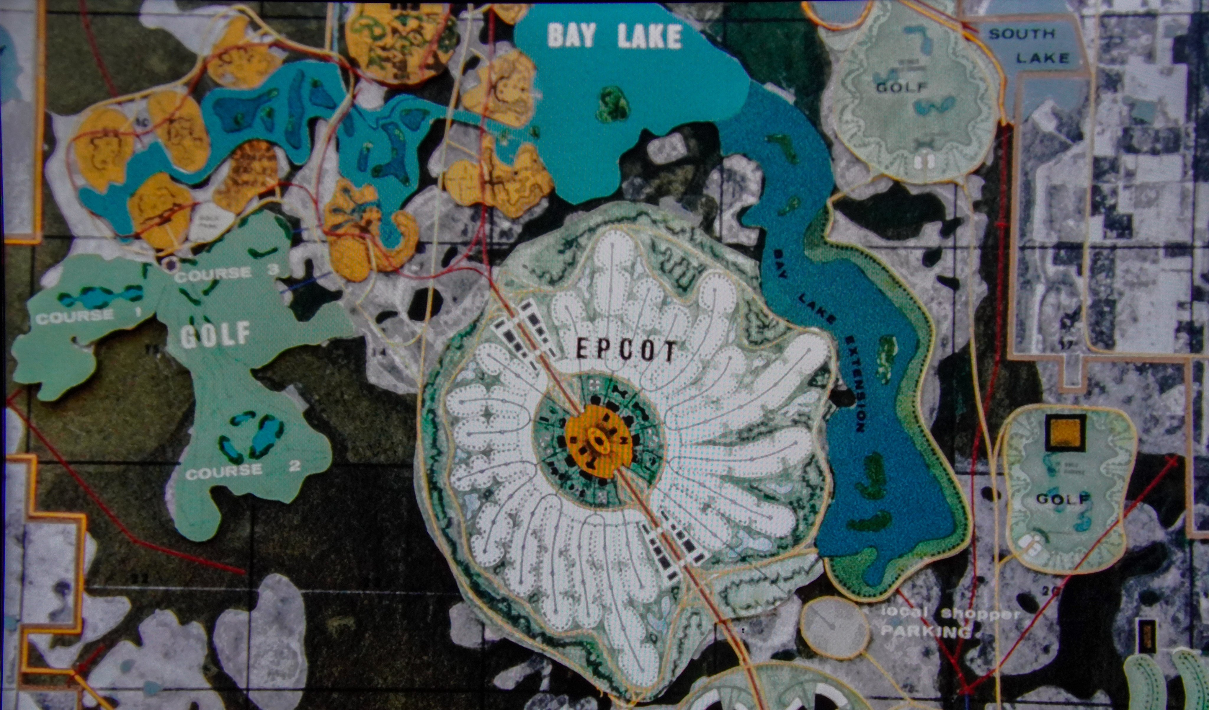
A follow-up to an Older Post I made involving the City of EPCOT proposal, maybe more images to come


Last edited:
Also, anyone have good inspo for Africa? I always have the absolute hardest time filling out Africa, and I have this idea of Swahili City-States conquering their way towards the west like Tippu Tip but I don't wanna just have space filling empires.
wip tax (beeg jenoa moment)
Maybe you could have a patchwork of protectorates or client states, like the British Raj. Certain groups like the Nyamwezi or the Great Lakes Kingdoms could have gotten enough clout to bargain for protectorate status instead of outright conquest.
IIRC, in Malê Rising there was some kind of small theocratic kingdom in the OTL Congo; maybe there's something similar to that, like a millenarian movement resisting the Swahili conquest. Alternatively, there could be an ongoing rebellion, or a condominium between two separate polities.
This is gonna sound kinda weird, but...Also, anyone have good inspo for Africa? I always have the absolute hardest time filling out Africa, and I have this idea of Swahili City-States conquering their way towards the west like Tippu Tip but I don't wanna just have space filling empires.
Take a map of Europe, rotate in 90 degrees and scale it to fit over Africa. These are your starting points.
Now, for each "country", look at what there is in real life there. Figure out what people live there and lived there, what history we have there, what the local geography is. Using these, you adjust the borders, and may end up splitting or merging some countries.
This method is a good start because it gives you a mix of large and small countries, and it gives you a framework to guide you rather than some overarching principle.
Attachments
If so that's completely accidental as I haven't seen it.That reminds me of @B_Munro ’s cover of Puritan World
I tried to revisit the old "East is West" flip with something between the Byzantines and the Persians serving as the China analogue.

Retooled maps from my TL called Storming the High Castle.
Map of the world in the immediate aftermath of the Veteran’s Day Event (November 11th 2018). The core territories of the United States and Canada were mass-teleported, along with all their overseas assets (civilian, military, undercover intelligence, satellites, etc.), to an alternate earth where the year is 1962. Non-core territories such as Puerto Rico and Guam were not brought along during The Event. In this alternate universe, FDR was assassinated in 1933, leading to a chain of events that saw the complete victory of the Axis powers in 1947. In spite of this victory, relations quickly soured between the Axis partners, and they are caught in the midst of a Cold War of their own - but with the Japanese lacking an atomic deterrent and several years behind the Germans technologically.

The power blocs of the world - the United States in blue, Canada in orange, Greater German Reich and its territories in red, the Japanese Empire in white. The ‘Neutral Zones’ of the world are rendered in dark grey.

A more detailed map showing the sub-divisions within the power blocs. The Germans lack the numbers needed to completely dominate their empire, allowing for local National Socialist regimes to rule as colonial stewards commanded by the Germans. All of them, even their former partners in Italy, have their foreign relations, economies, and militaries ran by Berlin. Japan is somewhat different - all their territories are run by Japanese Military Governors who dictate development, conscription, labor allocation, everything one needs to exploit their Pacific Rim-spanning empire.
Map of the world in the immediate aftermath of the Veteran’s Day Event (November 11th 2018). The core territories of the United States and Canada were mass-teleported, along with all their overseas assets (civilian, military, undercover intelligence, satellites, etc.), to an alternate earth where the year is 1962. Non-core territories such as Puerto Rico and Guam were not brought along during The Event. In this alternate universe, FDR was assassinated in 1933, leading to a chain of events that saw the complete victory of the Axis powers in 1947. In spite of this victory, relations quickly soured between the Axis partners, and they are caught in the midst of a Cold War of their own - but with the Japanese lacking an atomic deterrent and several years behind the Germans technologically.
The power blocs of the world - the United States in blue, Canada in orange, Greater German Reich and its territories in red, the Japanese Empire in white. The ‘Neutral Zones’ of the world are rendered in dark grey.
A more detailed map showing the sub-divisions within the power blocs. The Germans lack the numbers needed to completely dominate their empire, allowing for local National Socialist regimes to rule as colonial stewards commanded by the Germans. All of them, even their former partners in Italy, have their foreign relations, economies, and militaries ran by Berlin. Japan is somewhat different - all their territories are run by Japanese Military Governors who dictate development, conscription, labor allocation, everything one needs to exploit their Pacific Rim-spanning empire.
Last edited:
Reminds me of those Chinese adventurers in Crusader Kings 2.I tried to revisit the old "East is West" flip with something between the Byzantines and the Persians serving as the China analogue.
View attachment 837276

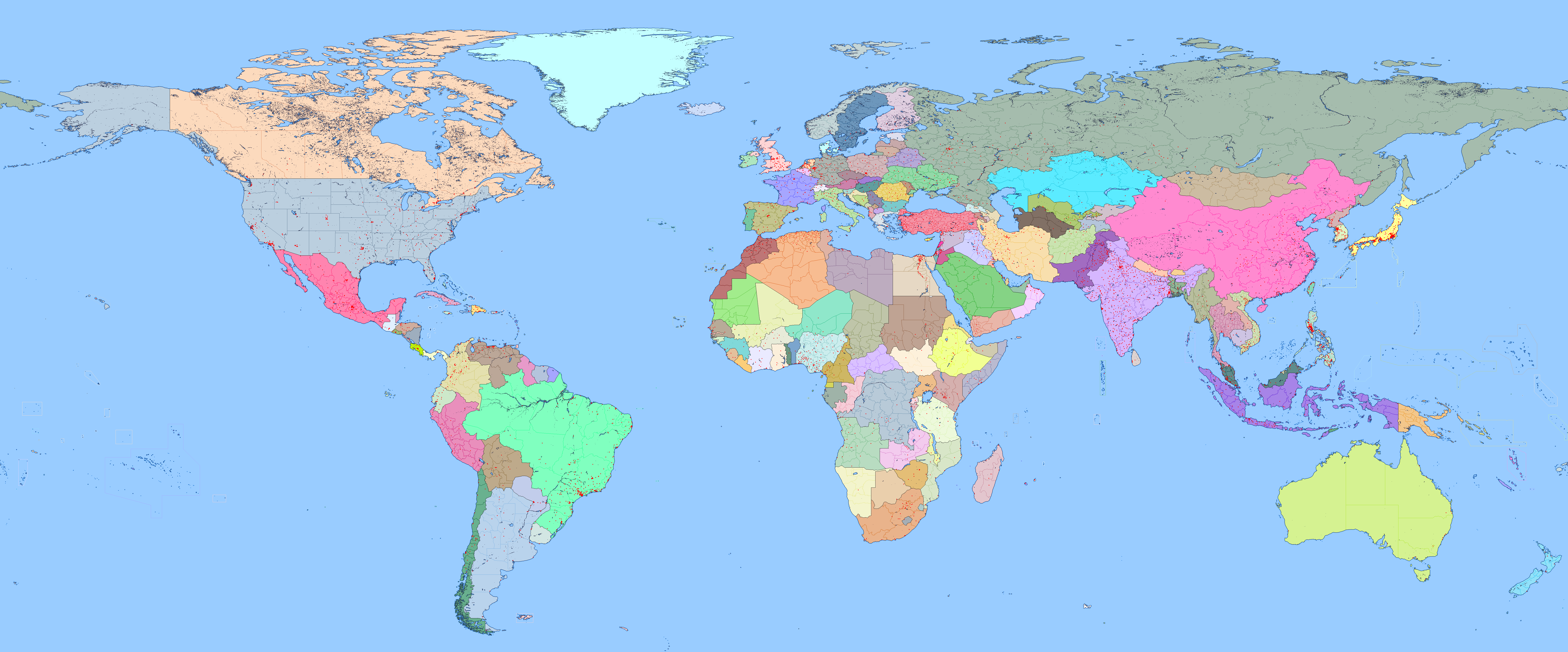
Every red dot represents a city with a population of 100.000 or more.
DISCLAIMER: This maps represents world cities with a population of over 100.000 inhabitants ALL ACCORDING to this series of Wikipedia Articles. A quick glance at the map reveals a crippling lack of Chinese cities. That's the result of the weird way China identifies its cities administratively. For example, the Chonqing province is, in its entirety, a single municipality, which was the classification employed for most other cases. Also the dates are not the same for every country and some of them are outdated (for example, Albany, NY, recently passed the 100k threshold but was not on the list). This map is also NOT a good indicator of population density either, rural areas can be heavily populated but consist of nets of cities below the threshold.
So, the map is completely wrong, and I only made it to waste some screentime.

I'm getting a weird Cthulhu vibe from the last picture especially.A follow-up to an Older Post I made involving the City of EPCOT proposal, maybe more images to come

View attachment 837218
View attachment 837221
It is interesting to see them planning to extend a lake. I wonder where they would have gotten the water to fill it with. I suppose from marshes, but even today a lot of the land isn’t used by Disney because it simply can’t be used. That, and it is awkward to have parks directly next to each other.A follow-up to an Older Post I made involving the City of EPCOT proposal, maybe more images to come

View attachment 837218
View attachment 837221
I was thinking the layer of some sort of Bond villain. He looks out the window of the space shuttle is being launched in, only to see their symbol on the ground. It helps that they seem to have renamed Bay Lack to Black Lake. Doubt Walt would go for the renaming for marketability purposes. Or maybe due to the risk of Universal Studies trying to sue them for ripping off the Black Lagoon. Not the most honest of lawsuits, but then it is a film studio.I'm getting a weird Cthulhu vibe from the last picture especially.
Well, hopefully the Mongols won’t have to move too much farther than before.I tried to revisit the old "East is West" flip with something between the Byzantines and the Persians serving as the China analogue.
View attachment 837276
Hmmm, the New York area would be a lot redder if not for all the forced city annexations. Well, I think it was forced, at least with Brooklyn. This map reminds learning as a kid that Mexico City was apparently the largest city in the world. I wonder if that was from including the entire capital district, as it seems to have a lot of big cities here.Every red dot represents a city with a population of 100.000 or more.
DISCLAIMER: This maps represents world cities with a population of over 100.000 inhabitants ALL ACCORDING to this series of Wikipedia Articles. A quick glance at the map reveals a crippling lack of Chinese cities. That's the result of the weird way China identifies its cities administratively. For example, the Chonqing province is, in its entirety, a single municipality, which was the classification employed for most other cases. Also the dates are not the same for every country and some of them are outdated (for example, Albany, NY, recently passed the 100k threshold but was not on the list). This map is also NOT a good indicator of population density either, rural areas can be heavily populated but consist of nets of cities below the threshold.
So, the map is completely wrong, and I only made it to waste some screentime.

Brooklyn voted for consolidation. It was the town of Westchester (what is now the Eastern half of the Bronx) which rejected consolidation. They did so by 1 vote. The state decide that was close enough and forced Westchester to join the greater NYC.Well, I think it was forced, at least with Brooklyn
The definition of largest city in the world is completely subjective as every country or organisms defines the limits of a city in a different way. Then there's the issue of conurbations and metropolitan areas. Anyhow, the most populated metropolitan area is Tokyo at 37M, the most populated municipality is either Chongqing at 32M (highly contentious, 70% of its population is rural) or Delhi at 28M, then Shanghai, Sao Paulo, and Mexico City. Mexico swallowed some nearby cities but only in the territory of the city proper, all dots are in the nehgiboruing states of Mexico or Morelos.Hmmm, the New York area would be a lot redder if not for all the forced city annexations. Well, I think it was forced, at least with Brooklyn. This map reminds learning as a kid that Mexico City was apparently the largest city in the world. I wonder if that was from including the entire capital district, as it seems to have a lot of big cities here.
Try doing this again with a few million years back Europe so that Indonesia will fit better with Islands.I tried to revisit the old "East is West" flip with something between the Byzantines and the Persians serving as the China analogue.
View attachment 837276
Threadmarks
View all 131 threadmarks
Reader mode
Reader mode
Recent threadmarks
[50+ Likes] Sultanate of England, by Sārthākā Big Nations series, by Alex0505 A re-projection of Jean Lattre's 1762 world map, by Ashtagon [50+ Likes] The Russo-Ukrainian conflict in context, by NeonHydroxide Rose, Tulips, and Liberty, by Unkown00 Caliphate of Albion 1450, by Sārthākā 1932 Centauri-Human War, by Alex0505 Bharata is the World (part 3) by wildviper121- Status
- Not open for further replies.
Share:
