Sorry - I did not see your post until just now. You are correct about the different species being human. The fifth one (purple on my map) is H. floresiensis.I'd have thought alternate human species, given those are Pleistocene sea levels and some of it matches the ranges of early H. sapiens, Neanderthals, Denisovans, Homo erectus and some mystery species which is almost certainly derived from erectus.
You are using an out of date browser. It may not display this or other websites correctly.
You should upgrade or use an alternative browser.
You should upgrade or use an alternative browser.
Map Thread XVII
- Thread starter Upvoteanthology
- Start date
- Status
- Not open for further replies.
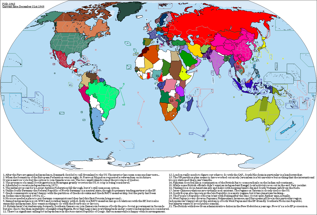
A very simple scenario without an extensive write-up. Due to different arrangements regarding the partition of Germany a movement to form a European League to counteract a potential German resurgence or a Soviet push towards the Rhine is formed. In 1967 the European League formally unites into the European Federation. The European Federation is partially inspired by this map by Blomma
Splendid! I really like the colours you used for Mexico, the EF, Australia and Pakistan.
A very simple scenario without an extensive write-up. Due to different arrangements regarding the partition of Germany a movement to form a European League to counteract a potential German resurgence or a Soviet push towards the Rhine is formed. In 1967 the European League formally unites into the European Federation. The European Federation is partially inspired by this map by Blomma
")
I wonder how active the Mafia is in independent Sicily.
I also like it that you were inspired by Blomma. Sometimes i wish he and Kuusinen were more active in mapmaking...
Okay. What if France and Germany were swapped in the long game ? Germany slowly nabbing at the lands of the Frankish Empire, before undergoing a revolution and conquering almost all of Europe, before being stopped in during their invasion of North Africa ?
Let me bring you, the Holy Frankish Empire. Just a shift and swap of countries' place in Europe. The POD would be vaguely around 770 ? Anyway. This is the map for 1066.

Based on @Bob Hope's most excellent basemap.
I'll post a list of the roles and how they've been turned around.
Let me bring you, the Holy Frankish Empire. Just a shift and swap of countries' place in Europe. The POD would be vaguely around 770 ? Anyway. This is the map for 1066.
Based on @Bob Hope's most excellent basemap.
I'll post a list of the roles and how they've been turned around.
I am seriously alarmed by everyone's apparently extremely high expectations for my map.
Here's another teaser. North Africa/Middle East still very tentative: I'm still working out how I'm going to color things for identification and grouping.
View attachment 353424
Communist Italy in a sea of non-communist Europe?
I really like this, you used a great colour palette and their are lots of differences that make this world look unique.
A very simple scenario without an extensive write-up. Due to different arrangements regarding the partition of Germany a movement to form a European League to counteract a potential German resurgence or a Soviet push towards the Rhine is formed. In 1967 the European League formally unites into the European Federation. The European Federation is partially inspired by this map by Blomma
How complete is Decolonization? Obviously their are still many British dominions and European whatever they call them's (also Portugal seems to have held on to nearly everything) of an apparently similar situation but I'm wondering how many are temporary moving along the path to independence and how many are comfortable and will stay in this situation long term? (Say what would the situation be by the year 2000)
As for the European federation itself, what level of separatist movements are there? And are there moments in other nearby countries to join them?
Perhaps Spain or Denmark?
Deleted member 94708
This and Mandeville have made me completely content with Worldwar getting pushed to the tail of the queue.The basemap I'm using is funny, and not in a ha ha way: it's hard to get colors the way I want, and blue keeps ending up too green or too purple. So I ended up in frustration going with orange/brown, which also can be used to indicate a rather authoritarian US.
Yes.
Yes!!!!!!!!!!!!!Ah, but you're forgetting the Americas and the sapient racoons.
Teaser for commission: anyone remember what this is?
View attachment 353270
I am seriously alarmed by everyone's apparently extremely high expectations for my map.
Here's another teaser. North Africa/Middle East still very tentative: I'm still working out how I'm going to color things for identification and grouping.
Very interesting Alt-Cold War.
What's it based on?
Communist Italy in a sea of non-communist Europe?
And don't forget Soviet Bulgaria.
I am seriously alarmed by everyone's apparently extremely high expectations for my map.
Here's another teaser. North Africa/Middle East still very tentative: I'm still working out how I'm going to color things for identification and grouping.
1953's War of the Worlds?
Splendid! I really like the colours you used for Mexico, the EF, Australia and Pakistan.
I wonder how active the Mafia is in independent Sicily.
I also like it that you were inspired by Blomma. Sometimes i wish he and Kuusinen were more active in mapmaking...
I'm no expert on the Mafia but it'd be stupid of me to assume that there wouldn't be active Mafia families active on an independent Sicily. And thanks for the praise ^^
I really like this, you used a great colour palette and their are lots of differences that make this world look unique.
How complete is Decolonization? Obviously their are still many British dominions and European whatever they call them's (also Portugal seems to have held on to nearly everything) of an apparently similar situation but I'm wondering how many are temporary moving along the path to independence and how many are comfortable and will stay in this situation long term? (Say what would the situation be by the year 2000)
As for the European federation itself, what level of separatist movements are there? And are there moments in other nearby countries to join them?
Perhaps Spain or Denmark?
Thank you ^^
Decolonization in this world underwent its second phase in the 1960s, leading to the independence of most of Africa and the first signs towards decolonization in the Pacific and the Caribbean. Places like Tonga, Fiji, Jamaica, and Ambazonia are scheduled to gain independence within the next three years and elsewhere nationalist sentiments are brewing. Even the EF and their "autonomous republic" approach isn't quite safe from it, since especially in the Congo there's a growing movement towards independence (largely inspired by and connected to the regime in Cameroun). I expect colonization to linger a bit more on the world by 2000 (a few less countries in the Caribbean, Gabon, a few extra places run by the Portuguese...) compared to OTL.
The EF's biggest problems are the Corsicans and some folks in the Rhineland (especially considering that the EF cleaved the Rhineland in two by using the river as the border and not following the old province border), however those movements are fairly fringe. There are some movements that call for the expansion of the EF and actually the country most interested in joining is Switzerland. Some Spanish pro-democracy activists are considering their options, including joining the EF, but the Francoist regime isn't interested. Denmark (and Norway) are quite close to the British and thus not really interested in joining the EF, especially considering that North Germany is in the way.
WIP

"Fuck Africa"
#AnotherWIPwithDissatisfaction
What do you think? Should I change it? Would it be ok if I just took the OTL colonial borders, since the POD isn't that far away, or should I change it drastically?
Africa gets colonized but this is pretty much post-colonialism borders here.
"Fuck Africa"
#AnotherWIPwithDissatisfaction
What do you think? Should I change it? Would it be ok if I just took the OTL colonial borders, since the POD isn't that far away, or should I change it drastically?
Africa gets colonized but this is pretty much post-colonialism borders here.
Surprised that there is that Syria color in Lebanon as though they claim it. Not that odd maybe, but I would think that they would also claim areas form Kurdistan or something. Considering no where else are land claims shown though, I am guessing it is just a pixel that got missed. Or perhaps some Syrian backed insurgents. Is there more than one Jewish states in this world, or is Zionist just used like a curse word or insult in this world? Though considering the alternative groups for Israel to be in is a German Global System, religious fanatics, and neutral demons... Yes, it is going to be interesting seeing what is in what group when you fill out the map key. Is the UASAP a recent creation? I feel they would have chosen just provinces or states if they had started it earlier on, back before the term state took on a different connotation. Plus you don't say North American, so I am guessing Canadian sensibilities aren't... ahhh, I am overthinking this again. Ahhh, you may want to change the Falklands into the color of an Argentine territory rather than state/province, as well as remove the yellow border lines within the Kuriles. It is the sort of thing that can get easily overlooked when editing a map. And what is the precise situation in the "Scottish Isles"? And I just realized this was your demon world. Been so used to seeing just Europe, and suddenly we zoom from the grey of Europe and there is a blast of color. Are California's internal boundaries based partially on the Franciscan missions? Also, what is that little autonomous area in Bengal? Special mountain everyone steers clear of? And are the areas with autonomy in Assam autonomous do to the OTL high Christian populatoin or do to some other reason? I do recall reading how there was a legend about a kingdom ruled by Amazon-like women that might be considered Megaphayla, while Nagaland... yah, the name says it all.WIP
"Fuck Africa"
#AnotherWIPwithDissatisfaction
What do you think? Should I change it? Would it be ok if I just took the OTL colonial borders, since the POD isn't that far away, or should I change it drastically?
Africa gets colonized but this is pretty much post-colonialism borders here.
Skallagrim
Banned
What do you think? Should I change it? Would it be ok if I just took the OTL colonial borders, since the POD isn't that far away, or should I change it drastically? Africa gets colonized but this is pretty much post-colonialism borders here.
First of all, you've done wonders with India, which you had some doubts about earlier.
Regarding Africa, I don't think these borders are bad. I think it's the fact that you've added internal divisions to almost all countries across the world, but not (yet) to the great majority of african countries. That makes Africa look more crude and undeveloped by comparison. Once you add internal borders, that should make things look a lot better, I think.
Side note: I don't know what's going on in the Amazon basin, but it looks cool!
And for my last act, I shall make Central America disappear!"Fuck Africa"
#AnotherWIPwithDissatisfaction
What do you think? Should I change it? Would it be ok if I just took the OTL colonial borders, since the POD isn't that far away, or should I change it drastically?
Africa gets colonized but this is pretty much post-colonialism borders here.
Now back to all those glorious subdivisions.
Keep in mind the sort of world this is. My guess is that here the Americans accepted that the Colombians wouldn't let them dig a canal through Panama so they found an... alternative solution.And for my last act, I shall make Central America disappear!
Now back to all those glorious subdivisions.
I think it looks pretty good, my only objection is that Namibia borderWhat do you think? Should I change it?
- Status
- Not open for further replies.
Share: