Can you provide links to all of this series? Maybe make a mini thread? I can't find your older ones in the series.Next instalment of my Christendom-screw circa 1250.
View attachment 360092
The King Vladimir of Lechia inherited the Saxon-Bohemian throne establishing the Great Baltic Empire (A.K.A. The Great Heathen Empire, the Neo-Hunnic Empire, the Lechian-Saxon Empire and the Dar al-Haram). After consolidating his rule he then proceeded to flex his new-found power in a series of conquests seeking to emulate and rebuild the old Saxon Empire at its height annexing the Geats, long-serving vassals of the Saxons, and the Magyars, as well as pushing the Romano-Bulgarians back to the Danube and making deep incursions into the Rus'. Despite their victories they are not invincible. The Baltic armies are significantly overextended and their expansion has been halted in a series of crushing defeats, the Baltic navy has been all but destroyed due to attempting to wars with the Thalassocratic Livonians and a disastrous attempted invasion of Britain and their rapid expansion has alienated all of their neighbours who are uniting against them.
In Volga Bulgaria intermarriage between the ruling Khans and the Abbasid exiles has resulted in the title of Khan and Caliph effectively merging and the Volga Caliphate has emerged as the chief power and self-proclaimed leaders of Islam on the steppe.
In the East the once mighty Khazar Empire has dissolved into several kingdoms due to a messy succession crisis exacerbated by a growing cultural rift within Khazar society, between the more urbanised Khazars around the coast of the Black Sea and the more traditional semi-nomadic Khazars in the east, as well as several subject peoples taking the opportunity to assert their independence.
The Romano-Bulgarians have experienced a bit of a mixed bag. Although they have lost ground in Europe and have been unable to successfully make incursions into pagan Illyria they have been able to solidify their position in Asia Minor and the Levant, the reestablished Kingdom of Judea ultimately being de jure absorbed into the Empire, and with the collapse of the Khazars they are the undisputed political leaders of Eurasian Jewry.
Facing incursions from the East and West the Rus', Livonians and remnants of Prussia have united into a Commonwealth. Combining the sea power of the Livonians with the military strength of the Rus', along with their close relations with the Sveas, the Russo-Livonian Commonwealth is the undisputed master of the Northern Baltic and chief barrier to Lechia-Saxony's eastern expansion.
The Ruman Caliphate are beginning to face setbacks on their periphery losing territory in Italy, Africa and Greece whilst their previously warm relations with Romano-Bulgarians have broken down.
You are using an out of date browser. It may not display this or other websites correctly.
You should upgrade or use an alternative browser.
You should upgrade or use an alternative browser.
Map Thread XVII
- Thread starter Upvoteanthology
- Start date
- Status
- Not open for further replies.
Late 10th CenturyCan you provide links to all of this series? Maybe make a mini thread? I can't find your older ones in the series.
12th Century
Late 12th Century
YES MADAGASCAR WILL SAVE US ALL FROM ANY DISEASE BECAUSE THEY WILL SHUT DOWN EVERYTHING!
The largest semi-plausible Madagascar I could come up with (I don't think Australia is feasible unless Malagasy circumnavigate the earth because Austronesian seafaring)
LET US RESPECT OUR MADAGASCAN RULERS SINCE THEY ARE SAVING US FROM EXTINCTION!
SHUT DOWN EVERYTHING IN THE WHOLE WORLD!
Now we just need an Iceland wank.YES MADAGASCAR WILL SAVE US ALL FROM ANY DISEASE BECAUSE THEY WILL SHUT DOWN EVERYTHING!
LET US RESPECT OUR MADAGASCAN RULERS SINCE THEY ARE SAVING US FROM EXTINCTION!
SHUT DOWN EVERYTHING IN THE WHOLE WORLD!

Still Russians out there?View attachment 360120
An ethnic map of Slovakia without Slovaks
Indeed. However we need to realize that most villages have like no more than 20 people and apart from the Hungarian, Rusyn and Roma zone the majority of Slovakia is populated very sparsely. The Czechs spread across a third of the country make only 5%, the majority are Hungarians (69%)Still Russians out there?
And then there is just how many areas on the map are shown without any minorities at all. Kinda makes me wonder if those are simply mountainous areas with basically no one there but centuries old communities. And try as I might, but I can't find where on the map Jews make a majority.Indeed. However we need to realize that most villages have like no more than 20 people and apart from the Hungarian, Rusyn and Roma zone the majority of Slovakia is populated very sparsely. The Czechs spread across a third of the country make only 5%, the majority are Hungarians (69%)
What reason was given by the Germans for invading? Here they somehow managed to get the industrially valuable portions fo East Silesia the Poels had, as well as the economically crucial ports of Danzig and Gnydia. Surprised they don't have the color of Slovakia here.heres a map where wwii started in november 1939 when germany invaded poland and the soviet union supplied lots of wepons to republican spain in 1936-1940, in december 1939 the soviets declare war on japen and invade manchuria, this is octobar 14 1939 mapView attachment 360217
There are 2 Jewish villages- one near Povazska Bystrica the other near KrupinaAnd then there is just how many areas on the map are shown without any minorities at all. Kinda makes me wonder if those are simply mountainous areas with basically no one there but centuries old communities. And try as I might, but I can't find where on the map Jews make a majority.
I suggest you post that HereView attachment 359592
I moved San Deigo County to Arizona, Prince Georges County to Florida, and Wayne County to Wisconsin and changed the vote.
That was easy.
I don't see the reference to any Azania here. Anyways, the Romans only that Azania 'in' East Africa because they didn't seem to really beleave there was anything in Congo, Angola, South Africa, etc. Makes sense that it would be send far to the south.Ooooooh, independent Cabinda, independent Zanzibar and independent Lourenço Marques. Interesting!
(Of course, the bizzarre notion of calling South Africa "Azania" - I know it's an OTL idea - always triggers me. It's historically inaccurate. Ancient Azania was in East Africa!)
To be fair for Sudan, it does derive from Arabic words meaning Land of the Blacks. The French also had their own Sudan in Mali, and both British and French Sudans touched Sudanese Savannahs, actually, know I am wondering just how many countries in the world somehow derive form 'land of' in some form or another. Anyways, for thinks like Sudan I think I think we can treat it the same as Guinea, which is in the name of half a dozen countries (if we count Guyana and French Guiana), none of which are in the original version of Guinea.Benin, Ghana, and Sudan are all geographically inaccurate as well.
We are to avoid posting maps we didn't make, correct? Never been clear if we don't do it if justness making an example. Anyways, looking at the map it shows... Well, it seems that's the mapmaker translated Land of the Black in their own way. Also, seems someone did an Ethiopia wank, yet demoted it to a Principality.
https://en.m.wikipedia.org/wiki/Guinea_(region)
fashbasher
Banned
I don't see the reference to any Azania here. Anyways, the Romans only that Azania 'in' East Africa because they didn't seem to really beleave there was anything in Congo, Angola, South Africa, etc. Makes sense that it would be send far to the south.
To be fair for Sudan, it does derive from Arabic words meaning Land of the Blacks. The French also had their own Sudan in Mali, and both British and French Sudans touched Sudanese Savannahs, actually, know I am wondering just how many countries in the world somehow derive form 'land of' in some form or another. Anyways, for thinks like Sudan I think I think we can treat it the same as Guinea, which is in the name of half a dozen countries (if we count Guyana and French Guiana), none of which are in the original version of Guinea.
We are to avoid posting maps we didn't make, correct? Never been clear if we don't do it if justness making an example. Anyways, looking at the map it shows... Well, it seems that's the mapmaker translated Land of the Black in their own way. Also, seems someone did an Ethiopia wank, yet demoted it to a Principality.
https://en.m.wikipedia.org/wiki/Guinea_(region)
According to the Oxford English Dictionary, Guyana is derived from an Indigenous Amerindian language and means "land of many waters".
Skallagrim
Banned
I don't see the reference to any Azania here. Anyways, the Romans only that Azania 'in' East Africa because they didn't seem to really beleave there was anything in Congo, Angola, South Africa, etc. Makes sense that it would be send far to the south.
You don't see it because @Iserlohn changed 'Azania' to 'Capeland' after I posted my comment.
Regarding Azania: the Greeks and Romans were pretty clear on where it was, really. It was definitely in East Africa, since it was described how long you had to sail beyond the horn of Africa to reach it. It is described as a coastal region, with prosperous trade cities. Azania's rough extent is illustrated on this map:
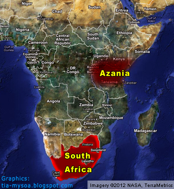
...this rather demonstrates the utterly ludicrous nature of the idea that 'Azania' corresponded to South Africa. More recent finds (based on the discoveries of Felix Chami) places the southernmost city of Azania (Rhapta) at the mouth of the Rufiji River in Tanzania, pretty much at the southern end of the map above.
And even here, the idea that Azania extended that far inland, as marked above, is based purely on conjecture. The actual sources only describe it as a coastal region. That said, Azania existed long before the Bantu migrations, and presumably, Africa east of the great Lakes was at that time (near-)exclusively inhabited by non-Bantu peoples, more closely related to modern-day Somalians, Ethiopians, Kenyans etc. (Considering the fact that the black inhabitants of South Africa, who now claim 'Azania' as theirs, are actually in most cases Bantus, the idea that they are 'Azanians' becomes even stranger.)
To be clear: I don't care one way or another what someone calls himself. If they want to call themselves the true heirs of Charlemagne, that's fine by me, too. But since this is a historical discussion board, some awareness of historical truth is of value here. That's why I stressed that South Africa certainly does not correspond to historical Azania, and that the identification of South Africa with Azania is a-historical and purely political.
A side project of mine that I finished recently, set somewhere around 1920 to 1925.
The first main POD are small, though successful and possibly accidental French landings in Ireland and southern Wales in 1796. This leads to a more hostile Britain during the Vienna Congress demanding the creation of a demilitarized Brittany and a Gibraltar like territory on a peninsula close to Brest. This creates a lasting animosity between the two countries that leads to Britain intervening in French expansion (see annexation of only lower Savoy and Morocco) and colonial ambitions.
After the Belgian Revolution Belgium gets partitioned according to a more pro-Dutch version of the Talleyrand-Plan.
The second major POD is a fourth Balkan war fought between Austria-Hungary and Serbia (read Russia) over the annexation of Bosnia (later than OTL). Despite the Russians not having a clear advantage the Austrian Army collapses after Hungarian and Balkan Regiments mutiny and nationalist uprisings start popping up in cities behind the front lines. When the Austrian government eventually loses control of the situation and Austria proper starts being threaten by social unrest Italy, Germany and Montenegro start intervening to protect Italians, Germans and Montenegrins respectively. The anarchy and uncertainty over borders is cleared up during the Treaties of Florence, around 1916.
The main points of contention today are the legal status of Poland, the Burgenland question, British-French Gibraltar (haven't made up a better name yet, suggestions are welcome) and the various nationalists in the Balkans.
I'm mostly looking for feedback on the overall style and layout of the page but questions and suggestions about the TL are also very welcome!
I'd like to continue working with this scenario so tell me if you have any suggestions to make it more realistic.
As with my last map I have the the topographic map, the rivers and city location all on separate layers so if you're interested in using them as a base for your own project let me know and I'll upload them somewhere.
I'm also open to suggestions on what country or region to draw next. I probably won't make a complete atlas so I thought I'd make pages for the countries people are most interested in
View attachment 360237
A side project of mine that I finished recently, set somewhere around 1920 to 1925.
I'm mostly looking for feedback on the overall style and layout of the page but questions and suggestions about the TL are also very welcome!
I'd like to continue working with this scenario so tell me if you have any suggestions to make it more realistic.
As with my last map I have the the topographic map, the rivers and city location all on separate layers so if you're interested in using them as a base for your own project let me know and I'll upload them somewhere.
I'm also open to suggestions on what country or region to draw next. I probably won't make a complete atlas so I thought I'd make pages for the countries people are most interested in
I really love this!
So what about the Americans, Asia, and Africa?
With this far smaller Belgium, and Dutch control of the Belgian coal mines and steel mills, the Netherlands could have a much larger Colonial Empire. (Dutch Congo anyone?)
How is the Ottoman Empire still standing?
Who is ally with who?
I try and come up with more ideas for this later when I can.
Please make a world map of this, but only with the capitals. When all the other parts are done in detail, obliviouslyView attachment 360237
A side project of mine that I finished recently, set somewhere around 1920 to 1925.
The first main POD are small, though successful and possibly accidental French landings in Ireland and southern Wales in 1796. This leads to a more hostile Britain during the Vienna Congress demanding the creation of a demilitarized Brittany and a Gibraltar like territory on a peninsula close to Brest. This creates a lasting animosity between the two countries that leads to Britain intervening in French expansion (see annexation of only lower Savoy and Morocco) and colonial ambitions.
After the Belgian Revolution Belgium gets partitioned according to a more pro-Dutch version of the Talleyrand-Plan.
The second major POD is a fourth Balkan war fought between Austria-Hungary and Serbia (read Russia) over the annexation of Bosnia (later than OTL). Despite the Russians not having a clear advantage the Austrian Army collapses after Hungarian and Balkan Regiments mutiny and nationalist uprisings start popping up in cities behind the front lines. When the Austrian government eventually loses control of the situation and Austria proper starts being threaten by social unrest Italy, Germany and Montenegro start intervening to protect Italians, Germans and Montenegrins respectively. The anarchy and uncertainty over borders is cleared up during the Treaties of Florence, around 1916.
The main points of contention today are the legal status of Poland, the Burgenland question, British-French Gibraltar (haven't made up a better name yet, suggestions are welcome) and the various nationalists in the Balkans.
I'm mostly looking for feedback on the overall style and layout of the page but questions and suggestions about the TL are also very welcome!
I'd like to continue working with this scenario so tell me if you have any suggestions to make it more realistic.
As with my last map I have the the topographic map, the rivers and city location all on separate layers so if you're interested in using them as a base for your own project let me know and I'll upload them somewhere.
I'm also open to suggestions on what country or region to draw next. I probably won't make a complete atlas so I thought I'd make pages for the countries people are most interested in
I try and come up with more ideas for this later when I can.
Thanks for the interest!
I think North and South America would look very similar to OTL since their wars were pretty isolated from European affairs. Maybe the Germans could press for a less humiliating peace for Spain in the Spanish-American war with support of the British in this TL. I'm still trying to work out how close German-British relations should be since I don't want it to be a Germanic Bromance Alliance.
The only certain thing I have for Africa are sold Portuguese colonies according to this plan (don't bother reading the thing just look at the images at the end). Seeing that they remained a monarchy in this TL I thought that the money from this transaction could stabilize the country for a while.
Other than that maybe divide the Congo between the neighbors and have an internationalized rump state.
Asia is reshaped due to the worse relation between France and Britain. Basically carved up Siam and more influence in China.
The Ottomans are better off but still struggling to keep their Arab possessions under control. Without the great war there wouldn't be internationally supported Arab revolts. The European powers use Constantinople as a gateway to Oil and such. Like with China there are zones of influence and the Turks are nowhere near equal partners in most treaties.
Still working on an alliance system that both makes sense and wouldn't immediately lead to a World War.
Please make a world map of this, but only with the capitals. When all the other parts are done in detail, obliviously
definitely on my list of things to do. I'm lacking a base map that fits my criteria and haven't planned out all regions yet.
Thanks for the interest!
I think North and South America would look very similar to OTL since their wars were pretty isolated from European affairs. Maybe the Germans could press for a less humiliating peace for Spain in the Spanish-American war with support of the British in this TL. I'm still trying to work out how close German-British relations should be since I don't want it to be a Germanic Bromance Alliance.
The only certain thing I have for Africa are sold Portuguese colonies according to this plan (don't bother reading the thing just look at the images at the end). Seeing that they remained a monarchy in this TL I thought that the money from this transaction could stabilize the country for a while.
Other than that maybe divide the Congo between the neighbors and have an internationalized rump state.
Asia is reshaped due to the worse relation between France and Britain. Basically carved up Siam and more influence in China.
The Ottomans are better off but still struggling to keep their Arab possessions under control. Without the great war there wouldn't be internationally supported Arab revolts. The European powers use Constantinople as a gateway to Oil and such. Like with China there are zones of influence and the Turks are nowhere near equal partners in most treaties.
Still working on an alliance system that both makes sense and wouldn't immediately lead to a World War.
definitely on my list of things to do. I'm lacking a base map that fits my criteria and haven't planned out all regions yet.
Maybe, or the Germans could let Spain get it ass kick in hard by the Americans to get Spain on it side. After the Peninsular War and the Napoleonic Wars, Spain is screw in every way possible. More so losing its Empire in South America and Mexico. Or even if the Germans, and British support Spain, it would be too late to do anything about it, and can't really force America to do anything. There just be no reason to support a declining Empire that is always fighting with itself between liberal and conservative factions. After Spain image is blow to tiny bits, Berlin, and London could do something. Maybe haven the war go even worst for Spain, and have it become a Republic again before going back to the Kingdom. (Because its Spain.)
Or you could be a little nice to Spain, and let it keep Peru. (As it was a Royalists stronghold till José de San Martín and Simón Bolívar kick down the door.) So it evens the Spanish-American War a bit. America still wins, but Spain still keeps Peru, and a position of some-kind in the Americans.
Save the Empire of Brazil! (And maybe keep insane
London would be much more worry about the balance of power with the growth of German power. Even if they not doing a 'Place in the Sun' Naval Policy, England, and Germany could/still be rivals, but not enemies.
English Mozambique? A divide Congo can be nice. (Germans, British, Portuguese.)
Eh. The Ottomans are still the Sick Man of Europe. The oil helps with modernization the Empire, but the Ottoman days are number.
Was they a Russo-Japanese War?
How is Norway, and Sweden still one kingdom? I like it, but not something you see a lot.
A World War is always going to happen at some point. Just a matter on when, and where, and by who.
Germany and Italy would be allies. (You fulfill a lot of Italian irredentism.) Or at least friendly. Same for Hungary, and most of Eastern Europe.
I try and think about Alliances when I can. (But Bulgaria and Russia could be pals/still pals.)
- Status
- Not open for further replies.
Share: