You are using an out of date browser. It may not display this or other websites correctly.
You should upgrade or use an alternative browser.
You should upgrade or use an alternative browser.
English Canada/French Carolina: A Timeline
- Thread starter Gabingston
- Start date
Threadmarks
View all 191 threadmarks
Reader mode
Reader mode
Recent threadmarks
Even More Revisions, Plus A New Announcement Part 150: The World As Of 1970 World Map As Of 1970 Part 151: America Revisited - The Thirteen Colonies Part 152: America Revisited - The Great Lakes Part 152: America Revisited - The Great Plains Part 154: America Revisited - The West Coast Resource Guide: Commonwealth Of America Locations As Of Part 154That appears to be the case.Good work.
Is Odessa considered a border town ITTL?
Hey guys, I am glad to have the Part 150 mega update out, and before New Year’s at that. I’ve decided that my next update will be about the Commonwealth of America. More specifically, it will be a revisiting of the country’s demographics and settlement patterns. I’m running it by you guys beforehand so I can get your input, but I’ve got some things in mind.
I’m pretty sure that I’ve already discussed this beforehand, but I think that I overshot the Commonwealth’s population in the past. 190 million by 1940 is definitely way higher than it should be realistically. I’m thinking something like 100-120 million at that time is more plausible, which would be around 135-150 million by 1970. This would change everything from the size of cities and provinces to the wars with the French and Spanish not being so lopsided (though the Commonwealth would still win).
Speaking of provinces, I’ve got a few changes that I’m thinking of making. First, some names. I’ve had the idea of renaming New Scotland, the former Scottish colony turned Commonwealth province that encompasses OTL’s Nova Scotia, New Brunswick, PEI and most of Maine to New Caledonia, both to make it more poetic (Caledonia being the Roman name for Scotland) and because New Scotland is kinda generic (the Pacific island would receive a different name ITTL, especially since it’s German). Then again, New England is still used as a name ITTL, so keeping New Scotland would make sense. Perhaps the two would be combined into a broader region called New Britain ITTL (with another Pacific island also getting a different name under the Germans). Furthermore, other locations in the Commonwealth, whether they be provinces or cities may also be renamed, in which case I will let you know in the update or in a separate post. I also am considering redrawing some of the provincial boundaries. For example, there were proposals IOTL for new British colonies in Appalachia (Vandalia) and in the Midwest (Charlotina), as well as another called Transylvania that was founded without support from the crown in what is now Kentucky and Tennessee. Implementing these into the TL in some form would be both plausible and a cool historical easter egg. In addition, I’ve considered making an Iroquois territory in what is now Upstate New York, though without the French in Canada the Anglo-Iroquois alliance very well may not exist. On that topic, there’s no guarantee that New York or Pennsylvania would expand across the Appalachians like they do IOTL, perhaps TTL’s western (and northern for New York) would be the Eastern Continental Divide, with an alternate province taking up the space on the other side. Reworking some of the borders in the Midwest to be less like OTL is also something I’m considering, though of course I’ll take your feedback before I make anything final.
Another alteration I want to make would be to historical migration patterns. According to the book Albion’s Seed (which I haven’t read, unless you count the Slate Star Codex blog post on it, so take my words with a grain of salt), there were four main groups of settlers in Colonial America that would go on to shape the culture and politics of the United States. Those were the Cavaliers in the Chesapeake, the Quakers in Pennsylvania, the Puritans in New England and the Scots-Irish/Borderers/Ulster Protestants in Appalachia. Now, I don’t see the first three groups settling in different locations from OTL, but the Borderers are a different story. With so many of them having Scottish origins, I think it’s inevitable that a large percentage of migration of Ulster Protestants to America would go to New Scotland/New Caledonia instead of Appalachia. This would have significant cultural and political ramifications for the Commonwealth. The Canadian Maritimes and Northern New England could have a culture more like OTL’s West Virginia or Kentucky and much of the Great Lakes and Upper Midwest would be more redneck than in our world. Given their tendency to push the frontier IOTL, I could also see a lot of them becoming involved in the fur trade, including the creation of TTL’s equivalent to the Métis.
If you have any feedback to leave, please do so. I’ve created a map showing my revision of the Commonwealth’s provinces east of the Mississippi, which I’ll share with you guys once this is posted. I hope to have the actual update out by the end of the month, it’s already over a thousand words and I haven’t even left the east coast, so it’s looking to be quite a long one. I’ll also post a poll on whether I should change New Scotland’s name to New Caledonia and likely one on whether I should revise the provincial map. UOTTC is also due for an update, I’ll just need to work out more of the details for that one. Regardless, I hope to hear from you guys regarding these plans.
EDIT: Made an edit to the previous update changing the Commonwealth's population from 176 million to 156 million.
Last edited:
Here is the provincial revision map I mentioned in the post. These borders aren't 100% accurate, as I didn't feel like redrawing the tiles on the base map (though I will do that on a future map once the timeline is complete), but it does give a good outline. I've used less straight lines for the borders and more natural features like rivers and watersheds. If you guys don't like it I will go back to the previous, more OTL like boundaries.
Where is this place located?New Scotland/New Caledonia name poll: https://strawpoll.com/BDyNEAV0wZR
OTL Canadian Maritimes + much of Maine.Where is this place located?
You feed my ego old friend. Here's a late christmas gift.
WORLD MAP AS OF 1970
One quick thing, we've reached the funny sex number page, so you know what that means:
@Gabingston What does Patagonia and America think of each other?
Last edited:
Both are British dominions, though America has to a large extent become the tail wagging the dog.@Gabingston What does Patagonia and America think of each other?
Yeah but do they have defense-treaties in case either of them are attacked by their neighbours? What are different about their cultures? Do they have a culture exchange programs to build bonds with each other? What is distinct about their literature and food choices? Is it possible to see an update about the Commonwealth of America culture? If not that, what is changing in central and South American cultures (do they treat their indigenous better than IOTL, movies, and cuisine choices)? This is an excellent story it’s just it would be nice to focus less on war and politics and more the differences in the Americas.Both are British dominions, though America has to a large extent become the tail wagging the dog.
Part 151: America Revisited - The Thirteen Colonies
Part 151: America Revisited - The Thirteen Colonies
The Part 150 mega update is now officially complete, and with it an entire epoch of EC/FC’s timeline, which now means we can move on from 1970 and through the late 20th Century, until we get another mega update set in the year 2000. The first update in this new era of EC/FC will be centered around arguably the primary player in this story, the Commonwealth of America. Originating as a series of British colonies stretching from the Chesapeake Bay up to Newfoundland, the Commonwealth had by 1970 been self-governing for nearly 200 years and had expanded from sea to shining sea (and also to frozen sea, but very few actually lived up there). Within this continent-spanning empire lay a vast amount of diversity, not just geographically but also culturally. Different colonies and even regions within the same colony were settled by different cultural and religious groups from within the British isles, creating a variety of regional cultures that lasted in some form to the TL’s present day. These founding cultures would interact and merge with later (mainly European) immigrants to create the modern culture of the Commonwealth. I’ll start on the east coast in this first part and move west in the second, along with a possible third update. Spoiler alert, there will be some retcons, let me know if you’re getting tired of those. As IOTL, there were thirteen separate colonial governments in British North America prior to the Commonwealth’s formation. These were, from south to north, Virginia, Maryland, Delaware, Pennsylvania, New Jersey, New York, Connecticut, Rhode Island, Massachusetts, New Hampshire, New Scotland, Laurentia and Newfoundland. Starting in the south, we have Virginia, the oldest British colony on the North American mainland. The warm climate of Virginia led to the establishment of plantations and cultivation of cash crops, worked at first mostly by White indentured servants but more so later on by African slaves, with the peculiar institution becoming an unfortunately central part of Virginia’s economy. The aristocratic nature of Virginia’s politics and culture was reinforced by the arrival of the Cavaliers, supporters of the King during the English Civil War of the 17th Century. The Cavaliers went about rebuilding the aristocratic, feudal society from which they came in the new world, with the indentured servants and slaves taking the place of the peasantry. The Virginian aristocracy wasn't devoid of positive characteristics, though, as many were extremely well read and educated, and would become a sizable share of the Commonwealth's early political leadership. With the decreasing yields of tobacco due to decades of intensive planting by the late 18th Century and the spread of Enlightenment ideals, a noticeable share of Virginian elites began to become less gung ho about slavery, and with the rest of the country being much less involved in and thus more opposed to the institution, many could see that it was on its way out by the 1830s. While slavery had expanded west of the Appalachians into the Ohio River Valley by the 1830s, it wasn't enough to stop the process of gradual emancipation that began that decade. Plantations and slavery within Virginia were most heavily concentrated within the lowlands along the Chesapeake Bay, with the backcountry being mostly populated by yeoman farmers who were often not very fond of the plantation-owning elite. After slavery’s complete abolition around the time of the First Global War, Virginia began to become less agricultural and more varied economically. Virginia’s cities, whether they be the river port city of Alexandria, the provincial seat of Richmond or the naval base of Norfolk, the cities of the Old Dominion were becoming larger and more important, especially since the advent of air conditioning made the hot Chesapeake summers more tolerable from the mid 20th Century onward. Virginia originally claimed all the land between the Ohio River and the Floridian border, but they had been made to give up their territory west of the Eastern Continental Divide to two new provinces, those being Vandalia and Transylvania. Most of Vandalia’s territory covered the southernmost part of the American section of the Appalachians, and its economy could be summed up in one word: mining. Coal mines in the hills employed thousands, as did the factories and power plants the coal was used in. There wasn’t a whole lot other than those industries, so if they were to ever close up shop it would cause an economic and social crisis in the province. Across the Kentucky River lay Transylvania, not to be confused with the region of the same name in Europe. In contrast to the mainly mining oriented Vandalia, Transylvania was more agricultural in nature. Transylvania had been pretty much the only place west of the Appalachians that slavery had been able to entrench itself in prior to abolition, and it held one of the largest proportions of Black residents of any province to the present day. Being on the Floridian border, Transylvania also had a sizable Francophone presence, with a number of Floridians moving back and forth across the Shawnee/Chaouanons. Including Vandalia in Transylvania in this update does make the title of the update a bit of a lie, but I already wrote it out before I decided to split the update into multiple parts, so I might as well keep what I’ve already done and accept a little bit of false advertising.
Now let’s head north from Virginia to the other side of the Potomac, bringing us to Maryland, which all things considered wasn’t too different from Virginia. The big difference with Maryland was with its origins as a colony for English Catholics, and while that didn’t last too long before it became just another English colony, the province still had a larger Catholic share of the population than most of the country. Maryland was one of the smallest provinces in the country when it came to land area, and thus only had room for one major city, that being Baltimore. Delaware immediately to Maryland’s east was the second smallest of the Commonwealth’s provinces, and didn’t really have anything of note, so we’ll now move north to Pennsylvania.
As with Virginia, Pennsylvania was one of the Commonwealth’s most influential provinces, for a variety of reasons. For one, it was one of the larger colonies in the colonial era, which naturally meant that it could support a larger population. The province’s climate was also as close to Western Europe as you could get on the North American east coast. To the south were the sweltering summers of the North American Southeast, and to the north were winters more akin to the Baltics or Scandinavia than to England. Pennsylvania was right in the transitional zone between the two, which made it ideal for settlement. The Susquehanna and Delaware rivers led deep into the colony’s interior, enabling easy transportation from the hinterland to the coast. The most important group of settlers in colonial Pennsylvania were the Quakers, a religious sect known for their pacifism, tolerance and industriousness. As a result, Pennsylvania would become a very pluralistic and mercantile province, with a large amount of settlement coming from the German states. PA was also among the first American provinces to abolish slavery, doing so before the year 1800. Philadelphia, established by the colony/province’s namesake William Penn, was one of the largest and most important cities in the country, with an urban area population surpassing four million. North of Philadelphia were the Lehigh and Wyoming valleys, two of the Commonwealth’s biggest hotbeds of industry. Between Philly, the two valleys and several other large cities, Pennsylvania was one of the most populous provinces in the Commonwealth, nearing nine million as of 1970. A major trend in the Commonwealth dating back to the colonial era was westward migration, and this was as true now as it had been in days of yore. As a result, Pennsylvania and other eastern provinces had more people leaving than coming in, mostly heading to the west coast, but we’ll get to that part of the country later.
Right across the Delaware River from Pennsylvania was New Jersey, a small but densely populated province sandwiched between two more influential ones. New Jersey did have large cities like Newark, Jersey City and Trenton, but these were either satellites of or overshadowed by larger cities like the aforementioned Philadelphia or a certain megacity I’ll get to shortly. Being in between two of the country’s largest cities did mean that New Jersey did punch above its geographic weight in terms of population and economy, being one of the most densely populated provinces in the country. New Jersey was known within the Commonwealth for its beach towns, which residents of the east coast would flock to during the summer (Delaware and Virginia were also beach destinations for east coasters), though cheap flights to the Caribbean were proving to be tough competition for the Jersey Shore.
Well, you know what’s coming next. That’s right, it’s New York. Concrete jungle where dreams are made of, there’s nothing you can’t do. The big apple, the city that never sleeps, whatever nickname you want to call it, there was no way that New York wasn’t going to become one of North America’s premier cities. The Hudson River which was navigable deep into the interior emptied into one of the Western Hemisphere's best natural harbors, which unlike those further north happened to be ice free year round. Much like nearby Pennsylvania, the climate fell into the goldilocks zone for Western Europeans, making the area attractive for settlement. NYC was originally founded by the Dutch as the colony of New Amsterdam, and while it’d been three centuries since the English acquired it, the mercantile prowess of the 17th Century Dutch carried over to the city long after the Dutch left. New York was the Commonwealth’s largest city, with an urban area population exceeding 10 million, one of the few cities in the world to have reached such a milestone by 1970 and the only one in North America to have done so. While many of them lived in neighboring New Jersey or Connecticut, the city proper alone put New York well within the top half of provinces by population. While not the political capital of the country, NYC was easily the most important city economically and culturally in the Commonwealth, and if it wasn’t number one worldwide it’d at the very least not be too far behind. New York was well known for its dazzling skyline, with several buildings stretching over 1,000 feet above the ground. Some of the most famous sports teams/clubs in the world played in New York, and numerous famous artists and celebrities came from the big apple. New York had been the main entry point for immigration from Europe, and as a result virtually every European ethnic group could be found to some degree in the city. There was also a substantial non-European population in New York City, mostly native born Black Americans with a smaller number of immigrants from the Orient, the Indian Subcontinent or Latin America and the Caribbean (expect that number to go up over the following decades).
New York was not a city state, though, but a fairly sizable province with a hinterland away from the densely populated coast. As was mentioned previously, the Hudson River that empties into the sea at New York City flowed hundreds of miles into the interior, being navigable all the way up to Albany, the former capital of the Commonwealth before the move to Chicago. Even after the national government packed up and headed west, Albany was still a decently important city due to its aforementioned river access and location between NYC to the south, Mount Royal to the north and Boston to the east. As with Virginia and Pennsylvania, New York’s claims west of the Applachians were forfeited to make way for new provinces, but that’s something for the next update.
East of New York was the region of New England, a small but influential part of the country that had an outsized influence on the culture and economy of the Commonwealth. While English explorers and fishermen had been visiting the region for decades and there’d been a short lived colony in the region’s north established around the same time as Jamestown, it would be the mass settlement of Puritans between the foundation of Plymouth in 1620 and the outbreak of the English Civil War in 1640 that really shaped the cultural trajectory of the region. The Puritans were a Calvinist religious sect that believed the Church of England held onto too many trappings of Catholicism and preached a hardline, back to basics form of Protestantism. The Puritans were both obnoxiously moralistic (hence their name) and remarkably industrious and productive. Literacy was nearly universal among the Puritans, and the Commonwealth’s equivalents to Oxford and Cambridge, Harvard and Yale, were both established by Puritans. New England merchants had been incredibly influential not just in the Commonwealth but in the broader Anglo-American Empire, and New England was a hotbed of maritime activity. The region comprised four provinces, those being Connecticut, Rhode Island, Massachusetts and New Hampshire. Each province had its own distinct characteristics, from the quaint coastal towns of Rhode Island to the mountains and forests of New Hampshire. The region’s largest city, Boston, was one of the most historic cities in all of North America, with the tight, winding streets of the North End having a distinct old world character. Boston was a hub of education, trade, industry and shipbuilding, with one of the Anglo-American Empire’s busiest ports being located in the city. Boston had been the host of the 1950 Winter Olympics, with the skiing being held in the White Mountains of New Hampshire, and as with New York, Boston had some of the most prolific sports teams in the country. New England’s universities were among the most prestigious in the Western World, and much of the American elite were alumni of those institutions. Boston had hosted the 1950 Winter Olympics (the skiing being done in the White Mountains of New Hampshire), and as with New York, Boston had some of the most famous athletic teams in the country. Aside from Boston, major cities in New England included Springfield and Worecester in Massachusetts, Providence in Rhode Island, Hartford and New Haven in Connecticut and Nashua, Manchester and Falmouth in New Hampshire (no Maine ITTL). New England was one of the most densely populated regions in the Commonwealth, especially in the southern three provinces, but the further north you went the less populated it got. For the first two centuries of its existence New England had been quite homogeneously WASP, but that would change with the influx of Irish refugees fleeing the famine (more on that later). Apart from the Irish, immigration to New England would be a mixture of British Protestants, continental Europeans and Jews, but we’ll get to more of the immigration stuff later on. For now, though, let’s head north to one of the most distinct provinces in the Commonwealth, New Caledonia.
The Commonwealth of America upon its formation was composed of thirteen different provinces. Of these, twelve had been under English administration prior to the Act of Union. The lone exception was New Caledonia, which as the name would imply was a colony of Scotland. Originally founded as the French colony of Acadia, it would be seized during the Anglo-French War of the late 1620s, after which it would be handed to Scotland as an olive branch to the junior partner in the union (though the then ruling Stuart dynasty was of Scottish origin. Over the course of the 17th Century the New Caledonia colony would gradually grow around the coastline, with a slow but steady stream of settlers arriving primarily from the Scottish lowlands. The big influx of settlers to New Caledonia would come in the 18th Century, and not directly from Scotland. After the English conquest of Ireland, the crown would bring in settlers from Britain to Ulster, the northernmost of Ireland’s four traditional provinces. Most of these British settlers came from the Anglo-Scottish borderlands, which had seen repeated invasions from both London and Edinburgh. As a result, the borderlands developed a militaristic, clannish culture, with cross border raids being commonplace. After the Plantation of Ulster was established and the personal union instituted, the monarchy thought “hey, why don’t we settle these folks in Ulster?”. Thus, over 100,000 settlers from Britain, pretty evenly split between England and Scotland, would cross the Irish Sea to the plantation. This wouldn’t be the end of the migration, though. For a variety of reasons ranging from religious tensions between the settlers and the crown and the sheer availability of land in the colonies, somewhere in the range of 150 to 200 thousand Ulster Protestants would emigrate to what would become the Commonwealth of America during the 18th Century. While these emigrants would settle across various parts of the country, such as in the Appalachian frontier further south, New Caledonia would be the largest recipient of Ulster Protestant settlers, both due to it being the closest part of the colonies to the motherland and the Scottish origin of many of the settlers. These settlers would pour into the previously sparse backcountry, such as in the St. John River valley and along other smaller rivers leading to the interior. These settlers and their descendants would eventually spread west into Laurentia, northern New England and the Great Lakes, with many becoming frontiersmen and/or fur traders. Scottish Highlanders would begin settling en masse in the colony in the middle of the 18th Century, centered in the northern part of the province around New Inverness and Dornoch (which I’d originally called Nipisigy but decided to change in favor of a town in the Scottish Highlands). Most of these highlanders spoke Gaelic rather than English as their first language, and while they would eventually Anglicize, Gaelic was spoken widely in the region for over a century. The highland settlers would spread north into eastern Laurentia and west alongside the Scots-Irish. As neither the Scots-Irish nor the Highlanders were business oriented cultures (though I did mention the fur trade a bit ago), the business and industrial class in New Caledonia’s major cities like Saint John, Crawford (originally Riversbend. I’m gonna try and make a lot of place names less generic), Leith and Perth were traditionally either New Englanders or more recent Scottish immigrants and entrepreneurs who came after Scotland’s industrialization. As with New England to the south, New Caledonia got a large wave of Irish Catholic immigration during and after the famine, settling in the aforementioned port cities. This wave of Irish immigration would lead to New Caledonia becoming nearly a quarter Catholic, twice the national average. With the influx of Irish Catholics would come ethnic/religious tensions similar to those in Ulster, and while it wouldn’t become as violent as those back in the motherland, there would be numerous smaller incidents over the decades.
We’ll take a quick hop across the Cabot Strait to Newfoundland, the easternmost and, ironically given the name, the oldest of the Commonwealth’s provinces. Originally inhabited by the hunter-gatherer Beothuk, the English would become interested in the island as early as 1497 with John Cabot’s expedition. Other European countries had also taken interest in the island, but by the mid 17th Century it was firmly under English control. The reason Newfoundland was of such interest to Western Europe’s colonial powers was what lay just offshore, that being some of the world’s most productive fishing grounds, the Grand Banks. English fishermen would begin to cross the pond to fish in the Grand Banks shortly after its discovery (though it’s speculated that some may have known about it even before Cabot), and seasonal fishing camps would pop up along its shores. Many of these camps would eventually grow and develop into permanent settlements, mostly small fishing villages but with a few larger towns as well. Newfoundland’s largest city, St. John's was a major regional port that had somewhat of an old world character, possibly because it was the closest city in the Commonwealth to Europe, with many quaint, painted houses that resembled those across the pond. The old world influence didn’t stop at architecture, as Newfies were known to have a distinct accent with characteristics similar to areas like Ireland or the West Country, two places where many fishermen had come from. This relative proximity to the old world also made it important to the burgeoning aviation industry, as it could serve as an important diversion airport if things were to go wrong on transatlantic flights or as a refueling station for planes that couldn’t fly such long routes nonstop. Other than St. John’s, Newfoundland was a very sparsely populated province, mostly consisting of the aforementioned small fishing villages with some small to medium sized towns scattered throughout. Most of Newfoundland was composed of coniferous forest interspersed with grassland, with small lakes and marshland scattered throughout, along with many small islands and islets off the coast. The western shore of Newfoundland had the most northerly section of the Appalachian Mountains, along with glacially carved fjords resembling a smaller version of Norway or the Pacific Coast we’ll get to in the second part of this update duo. Even heading into the latter part of the 20th Century, Newfoundland was still primarily oriented around the fishing industry, with more fish being caught now than ever before. Whether they were digging (or catching) too greedily and too deep was yet to be seen, but given OTL, the future of the Newfoundland cod fisheries might have some problems come 10 or 20 years. That would be a story for another day, though, as we’ll now traverse the Gulf of Saint Lawrence to the province which bore its name, Laurentia.
While the more southerly provinces had to find ways across the Appalachians into the American interior, Laurentia had an easy way to access the hinterland via the Saint Lawrence River from which the province got its name. Upstream from the river were the Great Lakes, five inland seas that contained 20% of the world’s fresh water. This made Laurentia the province with the easiest access to the middle of the country, especially once a set of canals were constructed to bypass various obstacles along the river.
The original colonizers of Laurentia were the French, who had established a colony at Québec and were looking to expand further along the river. David Kirke’s capture of Québec would change all that, as the English would now gain control over the colony, which would ultimately be ratified in the peace treaty. Québec was renamed to Kirkeston after its conqueror, and the nascent French colony of Canada would be renamed to Laurentia after the river which it lay upon. While the cold climate made it less appealing to settlers than areas further south, the geographic advantages made up for it enough for Laurentia to attract several times the amount of settlers that French Canada did IOTL. There was also substantial inter-colonial migration to Laurentia from other parts of British America, whether they be Scots-Irish and Highlanders to the backcountry or New Englanders to the growing urban centers of Mount Royal and Kirkeston. The 19th Century would see immense growth in Laurentia’s population and industry, even with older stock Laurentians moving west into the Great Lakes and Great Plains. Mount Royal’s incredibly strategic geographic location would not only make it an important inland shipping center but a rail hub as well. Mount Royal and Kirkeston were two of the largest ports of entry for European immigrants, whether they be British, Irish, German, Scandinavian, Slavic or Jewish. Mount Royal was one of the Commonwealth’s largest cities with a metro population of nearly five million, filling up basically the entire Mount Royal Island as well as neighboring areas across the Saint Lawrence, while Kirkeston’s urban area topped two million. Mount Royal had been awarded the 1974 Winter Olympics, which hopefully wouldn’t turn out to be as much of a disaster as the time Montreal hosted the Olympics in the 70s IOTL. Apart from the big two there were also a number of small to mid sized urban areas in Laurentia, the biggest of those being the neighboring cities of Three Rivers and Shawinigan (originally Chauenigan ITTL, but I figured I’d just use the OTL spelling) with a combined population of about half a million. As with other east coast provinces, Laurentia had originally claimed land stretching deep into the interior, in this case around the entire northern shore of the Great Lakes, but this land had been ceded to create new provinces. Those provinces, along with the remainder of the country, will be a subject for the next update, as this one has already become one of my longest to date (possibly the second longest after the previous one). There may be a third update depending on the length of the next one, so stay tuned for that. I am looking forward to finally moving into the last three decades of the 20th Century, and there will be another mega update when we get to the year 2000, but knowing the pace the TL has been moving at it might take a few years. Well, I’ll be back next month for part two guys, though it may take a bit longer than usual (going on vacation in the early part of the month). I swear I’ll eventually update UOTTC as well, but this TL is gonna be my main focus for the time being. The newest epoch of EC/FC is now underway, though, so there will be plenty of content to follow.
I've been thinking of some provincial names for the provinces ITTL's Midwest (plus Southern Ontario). I've come up with the following indigenous-derived names (mostly from rivers) as possibilities. I'll post some British or otherwise European names in a follow up post.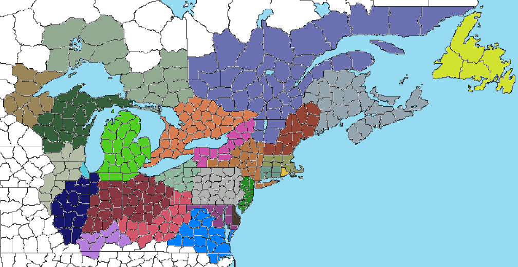
Here is the provincial revision map I mentioned in the post. These borders aren't 100% accurate, as I didn't feel like redrawing the tiles on the base map (though I will do that on a future map once the timeline is complete), but it does give a good outline. I've used less straight lines for the borders and more natural features like rivers and watersheds. If you guys don't like it I will go back to the previous, more OTL like boundaries.
- Southern Ontario: Ontario, Niagara, Toronto, Wentironk, Eshcanisipi, Kenhionhata,
- Upstate New York: Oswego or an Iroquois-related name like Haudenosaunee or Ganonsyoni.
- Northeast Ohio & Northwest Pennsylvania: Shenango, Erie (assuming it has the same name ITTL) or Allegheny.
- Ohio/Indiana: Ohio, Maumee/Miami, Ahsenisipi, Scioto, Muskingum or Wapahani.
- Michigan: Michigan, Karegnondi, Saginaw, Owashtanong, Manistee/Ministigweyaa.
- Eastern/Southern Illinois: Wabash, Kaskaskia/Okaw, Sangamon, Kankakee.
- Western/Northern Illinois & Southern Wisconsin: Mississippi, Inokasipi, Sinnissippi, Pecatonica/Bekaaniba.
- Wisconsin & Upper Peninsula: Wisconsin, Meskwahkiwsipi/Nionigera, Chippewa/Hahatonadeba,
- Western Wisconsin & Northeast Minnesota: Mesabi, Gichisipi/Okijisipi, Onigaminsing.
Last edited:
With the Indigenous names listed, it's now time to list the British or European derived names for the Midwestern provinces:
- Charlotina, a name the British used for a proposed colony in the Midwest east of the Mississippi and west of the Wabash River. I will for sure use this name for one of the three provinces centered in Illinois or Wisconsin.
- Lacusia, which is Latin for "land of the lakes", might be used for either Michigan or Wisconsin/UP.
- New Hanover, named for the ruling House of Hanover. It could be used for any province in the region.
- Augustina, for King George III's mother. As with New Hanover, any province could work.
- New (insert British region here). which like the previous two works anywhere.
- New Brunswick, which doesn't exist as a province IOTL's Canadian Maritimes but could feasibly be the name of an alternate province ITTL somewhere in the Midwest.
Part 152: America Revisited - The Great Lakes
Part 152: America Revisited - The Great Lakes
With the original Thirteen Colonies (plus Vandalia and Transylvania) covered in the previous update, it’s time we move into the heartland of the Commonwealth, the Great Lakes. Over the course of the 19th Century the Commonwealth of America would expand across the entirety of North America, from the Appalachian Mountains in the east to the Pacific Ocean in the west. The plains and woodlands of the North American center would be turned into one of the world’s great breadbaskets, and new cities would spring up left and right. Millions from both within and outside of the Commonwealth would flood into the interior to work the land or to make it rich in one of the aforementioned new cities. The Commonwealth’s heartland would become one of the world’s biggest industrial regions, which would be one of the main catalysts for the Commonwealth to become the world’s largest economy. With the country’s center of gravity shifting towards the interior, the Commonwealth would relocate its capital to the biggest boomtown of them all, that being Chicago. I think I’ve done enough in the intro, so let’s move into the Commonwealth’s interior, starting east and moving our way west to the Rockies.Before we do that, though, I should probably talk about a province on the east coast that I forgot to discuss, that being the American part of the Caribbean. The Commonwealth of America had been granted the islands of the Bahamas, Turks and Caicos, along with the island of Bermuda off in the Atlantic. These islands were combined in 1956 to form the new West Indies province, with its capital being placed in Nassau. The province of West Indies was notable for being the only majority Black province in the country, though the Black West Indians were culturally distinct from their mainland cousins. Previously cash crop producing colonies like the rest of the Caribbean, tourism to the West Indies province began to surge after the advent of mass commercial aviation. Beach resorts and hotels were beginning to pop up left and right along the islands’ shores, with people especially coming during the winter to escape the cold. The West Indies were easily the southernmost province in the Commonwealth, and the only part of the country to reach into the tropics. While the battering from hurricanes the islands would take was an issue, the future of the West Indies province looked bright nonetheless.
We now return to the mainland, where we have our first interior province, that being Oswego. Named for the river which bisected it, Oswego was yet another industrial province, a theme we’re going to encounter quite a bit throughout the course of this update. The major Oswegan cities of Utica, Syracuse, Rochester and East Niagara were major centers of industry in the region, with the Hudson Canal running from the eastern end of Lake Erie to Hudson River across the whole width of the province. Oswego was also notable for having the largest concentration of Amerindians of any province east of the Mississippi River, as it was the heartland of the Six Nations. The Six Nations had been one of the most advanced and, for lack of a better word, civilized groups of Amerindians north of Mesoamerica, and had even built an empire of their own across the North American center in order to better control the fur trade. While those days were long gone and the nations had lost most of their land even within their homeland, they were certainly a lot better off than tribes further west were, and the native influence in Oswego ran strong, particularly in the Finger Lakes region. Oswego had two major natural attractions as well, those being the Adirondack Mountains in the east and Niagara Falls in the west. The Adirondacks, shared between Oswego and Laurentia, was one of the largest wilderness areas in the eastern half of the country (excluding the sparsely populated north), with Adirondack National Park receiving millions of visitors each year. The Adirondacks hosted the skiing events for the 1974 Mount Royal Winter Olympics, which would only further raise the profile of the region and make it one of the largest skiing destinations in North America. Niagara Falls, the other major natural attraction in Oswego, was also shared with another province, in this case Ontario (more on that in a bit). While it had in the past been a hindrance to transportation, the 50 meter high, horseshoe-shaped falls were now a famous landmark of the Commonwealth’s heartland, especially with its location at the center of the large Niagara metro area. Speaking of that, though, let’s go to the other side of the falls and talk about Ontario, shall we?
Bordering three of the five Great Lakes, Ontario was an important province for transportation and industry. The Niagara Canal had been constructed to bypass the falls and connect Lake Erie and Lake Ontario for shipping traffic, and a similar canal had been built between Lake Huron and Lake Ontario via Lake Wentironk. Lake Ontario supported several large cities like West Niagara, Augusta, Toronto and Catarockway, each of which had their own shipping port. Ontario was also home to several large cities away from its namesake lake, namely Ottawa (originally spelled Odawa ITTL, but I’ve changed it to OTL’s spelling), Zooniang, Brunswick and Georgiana. Ontario was split roughly in half between an agricultural south and a forested north, with the former having most of the population. Ontario ITTL only consists of TTL’s Southern Ontario, with the north comprising a different province, but we’ll get back to that later.
South of Lake Erie we have several more provinces to talk about, the first of those being Allegheny. Spanning the eastern half of Lake Erie’s southern shore, Allegheny was yet another core province of the Commonwealth’s industrial heartland. The provincial capital which bore the name of the lake was one of the largest port cities on the lake and a large industrial center to boot, whose harbor was sheltered by the long Erie Spit. Allegheny also contained the northern half of the Pittsburgh metro area (I’d originally called Pittsburgh Cumberland ITTL, but it turns out I mistook Fort Cumberland in Maryland for it). Located at the confluence of the Monongahela and Allegheny rivers, Pittsburgh had been established as a military outpost in the 17th Century. As the industrial revolution progressed, Pittsburgh would become a major industrial hub, particularly when it came to the steel industry due to its easy access to minerals. While the city proper fell on the Vandalian side, Allegheny still had nearly half of the Pittsburgh metro’s population and a lot of its industry, making it the province’s largest population center. Some other prominent cities and towns in Allegheny were Youngstown, Kittanning, Cleveland, Dewsbury and Ashtabula. All things considered Allegheny was a middle of the road province in terms of national importance, but that isn’t true of the next one we’ll talk about. We will now cross the Cuyahoga River into the province of New Hanover, one of the largest and most important provinces in the central part of the Commonwealth. Bordered on the south and east by the Ohio River, the north by Lake Erie and Miami River and the west by the Wabash, New Hanover had become a powerhouse of a province. Along Lake Erie lay Sandusky (originally Sandusty ITTL, but I now think OTL’s name sounds better), the province’s main port on the Great Lakes and a city that is larger and more important than IOTL. Sandusky was notable for being the home of the Sandusky Autodrome, a massive racetrack that hosted the Commonwealth 500 race each summer. The central part of the province had several sizable cities like Mansfield, Rockton, Concord and the provincial capital of Hanover. The entire southern and much of the eastern border of the province was formed by the massive Ohio River, and along (or near) its banks lay the cities of Muskingum, Portsmouth, Losantiville and Crescentville. New Hanover was a leader in multiple economic fields ranging from industry to agriculture and with a population surpassing 10 million was also a politically important region. With its central location, large population and settlement from all of the Commonwealth’s regional cultures, New Hanover was considered a province that was representative of the country on whole, the core of the country’s heartland. We’re not done just yet, though, so let’s head north to the Commonwealth’s mitten, Michigan.
Surrounded on three sides by the combined Lake Michigan-Karegnondi, Michigan was yet another heartland province centered around agriculture and industry. The south had become part of the Commonwealth’s vast central breadbasket, while the north was more forested and had a large lumber industry. The province’s premier city, Windsor (originally Stuarton ITTL, but the Stuarts aren’t on the throne, so the name likely wouldn’t be kept), spanned both sides of the river of the same name (thus sharing it with Ontario) and was a major logistical, industrial and interior shipping hub. Some of the province’s other large cities were Arboria, Kalamazoo, Grand Rapids, Owashtanong, Muskegon and Wequetong. As with New Hanover, Michigan was considered a good representation of the country on whole, and candidates and parties that won in these two provinces would most often win the national election.
Heading back south we have the province of Augustina, named for the by this point long deceased mother of King George III, Princess Augusta. Located between the Wabash River to the east, Inoka and Mississippi Rivers to the west, Lake Michigan and Chicago to the north and Ohio River to the south, Augustina was a core part of the Commonwealth’s breadbasket. Most of the province was covered with miles upon miles of grain fields, so while it was quite boring to drive through, it was important nonetheless. The province’s capital city, New Gotha (named for Augusta’s birthplace), was a fairly average American city, which could also be said about others in the province like Sangamon, Williamstown and Teeyakeke. Much of Augustina’s population, though, lived in the northern edge of the province in the southern suburbs of the nation’s capital, Chicago (which I’ve already done an update about fairly recently). This had been going on since the beginning of the 20th Century, but was accelerating in recent decades as people poured into new developments outside of the capital district. Augustina did have a small coastline on the south shore of Lake Michigan, with the city of Port Augustina serving as its access to the Great Lakes. On the topic of the Great Lakes, let’s hit the rest of the Great Lake provinces, starting with the two Charlotinas.
Charlotina, named for Queen Charlotte, had been a name used for the western Great Lakes region in general during the latter part of the 18th Century. As more provinces were created it became more specifically used for the area between Lake Michigan and the Mississippi River. When the Charlotina colony was to become an official province in the mid 19th Century, it was decided to split it in two along the Wisconsin River and 43.5 degrees north latitude, which was conveniently at the river’s easternmost bend. Thus, North Charlotina and South Charlotina were born.
We will start in the south, the more populous of the two provinces. As with Augustina, a large share of South Charlotina’s population resided in the Chicago suburbs outside of the capital proper. Outside of the Chicago suburbs, Charlotina had a few notable cities. The biggest of these was Milwaukee (originally Millocky ITTL, but I’ve opted to use OTL’s spelling instead), located 80 miles north of Chicago along Lake Michigan. Milwaukee, as IOTL, was basically a smaller version of Chicago, with the two cities growing more and more connected by the day. Between the two large cities were several smaller ones along the lake like Rootport, Kenosha and Waukegan. In the province’s interior were the cities of Lacusia, Mirow, Strelitz and the provincial capital, Charlottesburg. Now we’ll move across the 43.5 latitude to the less populated, more wild of the two Charlotinas, that being North Charlotina.
Despite being geographically larger than its southern twin, North Charlotina had less than half the population. While nearly all of South Charlotina that wasn’t covered by urban development was used for agriculture, the northern half of North Charlotina was covered by one of the largest forested areas in the Commonwealth outside of the northern taiga. North Charlotina thus had a large lumber industry, with North Charlotine wood flowing to sawmills and factories inside or outside of the province. North Charlotina also had a sizable amount of agriculture in its southern half and had a number of mines, notably iron mines in the north. As for its major cities and towns, North Charlotina had Sheboygan, Spirit Harbor and Green Bay along Lake Michigan, Zibing along Lake Gichigami and Aconema, Kew, Wausau and Mecklenburg in the interior, the last being the province’s capital (yes, I know this is getting a bit repetitive). We will continue our journey west across the Commonwealth shortly, but we’ve first got to take a small detour northeast to the province of Gichigami.
Hugging the north shore of the eponymous lake, Gichigami was one of the most sparsely populated provinces not just east of the Mississippi, but in the country period. The largest city in the province was the capital of St. Mary’s (originally Bawitigong, but I figured that I could name it after Mary II and thus keep a version of the OTL name), which sat along the river of the same name between Lake Gichigami and Lake Karegnondi across from North Charlotina. The river was marked by a set of large rapids, which were a major obstacle and hazard to navigation until a series of locks and canals were constructed to circumvent them. St. Mary’s wasn’t just a shipping choke point but a rail hub as well, as rail lines heading northwest from Mount Royal and north from Ontario and Michigan converged around St. Mary’s. While it wasn’t as big of a transport hub as Chicago or the aforementioned Mount Royal, St. Mary’s was either the most or the second most important city in the northern Great Lakes region. The other large lakeside city in Gichigami was Gaministigwea, which sprung up around a fort and fur trading post in a sheltered harbor along the northwest shore of the lake. While not as large as St. Mary’s or a city we’ll get to shortly, Gaministigwea was still an important regional center. Apart from those two, there wasn’t a whole lot going on in Gichigami. The province’s interior had the sizable mining town of Nickelburg as well as Portage which was split down the middle between it and Ontario, but other than that Gichigami was mostly sparsely populated forest.
We now move west across Lake Gichigami to Mesabi, the final of the Great Lakes provinces. Located between Lake Gichigami, the Mississippi River, the Hahatonadeba River and a variety of waterways in the north, Mesabi was the beginning of the transitional zone between the Great Lakes to the east and the Great Plains to the west. The province’s capital, Onigaminsing, was the westernmost point of the Great Lakes, and was thus a major port for goods coming from the surrounding region. The most notable of these were lumber and iron. As with other provinces in the upper Great Lakes, the rich forests of Mesabi led to the growth of the lumber industry, with the vast strands of pine, spruce and birch being felled and sent down the various rivers and streams to sawmills and lumber yards. The other major good was iron ore, which Mesabi had large deposits of. The ore mined in the iron range would be sent down to the port, from which it’d be exported to steel mills in the Commonwealth’s major cities. Onigaminsing wasn’t the largest urban area in the province, as it shared an urban area with neighboring Minnesota (more on that in the next update) which included the city of Dover (named for the white cliffs along the river reminding the settlers of the Cliffs of Dover) on the Mesabi side of the Mississippi river. The metro area, which Mesabi had the northern and eastern half of, comprised about half of the province’s population, and apart from Dover and Onigaminsing there wasn’t a whole lot of urban development in the province. There were several smaller towns and cities like Stillwater, Anoka, Cedarville, New Laurentia and Mookoman, but outside of the main two cities the province was overwhelmingly rural.
I was originally going to cover everything up to the Rockies, but this is already a long enough update and I want to get something out in February, so I’ll end it here. In the next update we will cross the Mississippi into the Great Plains, which depending on the length will either be the third of four updates or be combined with the West Coast to make one large final third update. I promise I won’t spend all of this year infodumping about the Commonwealth, but there’s still a way to go. I’ll have the third part out in March, and the fourth either in March or April depending on the pace I work at. UOTTC will be back sometime, I’m just kind of at an impasse with it, so this is the TL that is getting all of my attention. Well, I hope you guys have enjoyed this update and that you’ve had a good February. I’ll catch you guys next time.
Threadmarks
View all 191 threadmarks
Reader mode
Reader mode
Recent threadmarks
Even More Revisions, Plus A New Announcement Part 150: The World As Of 1970 World Map As Of 1970 Part 151: America Revisited - The Thirteen Colonies Part 152: America Revisited - The Great Lakes Part 152: America Revisited - The Great Plains Part 154: America Revisited - The West Coast Resource Guide: Commonwealth Of America Locations As Of Part 154
Share: