A map of the Indian Front in my TL showing frontlines between the United Republic of India in the north and the nations of the British Commonwealth in the south. circa 1976. (Sorry for the lack of detail but it wouldn't let me make it any bigger)

You are using an out of date browser. It may not display this or other websites correctly.
You should upgrade or use an alternative browser.
You should upgrade or use an alternative browser.
Map Thread XII
- Thread starter Baconheimer
- Start date
- Status
- Not open for further replies.

Well the Americans and Germans have been hating each other for a while, but the real trigger is the Americans putting nukes in Britain (the Germans quickly snuck nukes into the Dutch caribbean in response).Why are they launching a nuclear war?
The Restored Roman Empire
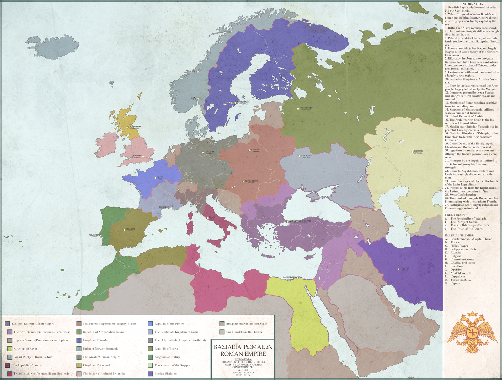
I used to be a regular AH.commer some years back but though I occasionally still look up the maps here, I long abandoned my membership here. Not that I' really left so much as moved on to DeviantArt though perhaps not making as many maps/profiles as before. Nonetheless, I thought of leaving a parting present or two to the forum. Hopefully this makes up for it.
I used to be a regular AH.commer some years back but though I occasionally still look up the maps here, I long abandoned my membership here. Not that I' really left so much as moved on to DeviantArt though perhaps not making as many maps/profiles as before. Nonetheless, I thought of leaving a parting present or two to the forum. Hopefully this makes up for it.
Well the Americans and Germans have been hating each other for a while, but the real trigger is the Americans putting nukes in Britain (the Germans quickly snuck nukes into the Dutch caribbean in response).
Curaçaoan missile crisis?
I used to be a regular AH.commer some years back but though I occasionally still look up the maps here, I long abandoned my membership here. Not that I' really left so much as moved on to DeviantArt though perhaps not making as many maps/profiles as before. Nonetheless, I thought of leaving a parting present or two to the forum. Hopefully this makes up for it.
You know your nation is real when it has "legitimate" in its name.
The Japanese colonies are still pretty empty at this stage.
Any chance of further maps of the Thaiwantinsuyu (Australia switched with S. America) series? I did love it, so please continue!
This is my shot at a true 'mirror' world. As a game, I want you folks to see if you can spot the analogues. This world is as of March 24, 2014, btw.
View attachment 227008
What about more analogies?
Norway, Sweden, Iceland= Cambodia, Laos, Vietnam (powers that are still capitalist). Also, Helgoland seems to be (possibly) the Senkaku Islands? Is there a Helgoland Island Dispute going on?
Peru= Iran, with an extremely Inca revivalist government. Naturally with a Sapa Inca in the role of Khomeini! Alternatively, Mexico is Iran with an Aztec extremist government and the Tlatoani as Khomeini.
Bolivia is Afghanistan, thus had also got an extreme Native American government and supported *9/11 in Leningrad? Chile again as Pakistan and Argentina (or Brazil?) as India?
Maybe, Japan is the United Kingdom, with Manchuria as (Mega-)Ireland and North Korea as Northern Ireland? South Korea maybe as an *independent Scotland? If that is the case, *Über-Vietnam as France and Cambodia as Switzerland?
Ecuador as Iraq, then, the state which was invaded by the USSR recently on the false pretext it had WMDs, and now is occupied, if Syria is Colombia?
Finland as Canada, the state which steadfastly does not want to be compared or annexed with it's big neighbour?
Then, Yugoslavia is Mexico?
If that is continued, Germany could serve as Brazil, France as Argentina, et al.? And these are then states where the Soviets supported dictatorial communist regimes and military Juntas? In what is called Operation: Falcon in the 70s and 80s?
Poland could be Colombia (how cool that would be, the Polish mafia led by Lech Walesa in the role of Pablo Escobar, anyone?) Czechoslovakia like Paraguay, Romania like Uruguay, Italy might be Peru,...?
West Africa seems to be, strangely enough, another Middle East analogue, but it is distorted: Mauritania as Saudi-Arabia, West Sahara as Yemen(?), Songhai (as I will call that Maliwank) as Iran, in an eternal rivalry with each other, Liberia as Syria, Kong (Ivory-Coast-wank) as Iraq, and Nigeria as Turkey.
But both of those lack an Israel, despite the fact that there seem to be two Israels: One capitalist in Israel, and one communist in East Prussia (maybe the state analogue of the US Jewish community?)
Any chance, theHombre, of the questions getting answered soon?
I really liked Semmi's CP victory map series, so I decided to have a go at my own take.
The world in the late 1960's/early 1970's:
And here, any chance at a continuation? I loved that commiewank!
Ahh... But of course.
The UK = Japan, Northern Ireland = North Korea and the Republic of Ireland = the Republic of Korea.
Right?
What did you mean by "sort of", theHombre?
Crossposting my MotF entry

When the Monarchy was executed by the Socialists, the Western World was in an outrage, but following the collapse of the United States, the Soviet Union as the only remaining superpower did not bat an eye. When Scotland and Northern Ireland seceded for independence and to join Ireland respectively, the people of the Isle of Man then began to panic. The Military gained control of the island and it became a base of operations for resistance forces in the English Republic. In order to placate the people of Mann, they allowed all the names of the towns to be changed into Mannish once it became obvious they were going to be there for the long haul.
Crossposting from my MotF entry. Remembering Susano, by the way.

Do you remember Susano, one of the most notorious of our German members that eventually got banned in early 2011 for racist hate speech in Chat? I remember when we two discussed federal reform in a surviving Weimar Republic. One of his most remarkable stances was absorbing the Hanseatic city states with one another instead of neighboring bigger states. MotF 95 is the right opportunity to show it off.
Like its precedessors, the United Hanseatic Free State, or Hansestaat for short, is actually a constitutive state of the republican German Reich that IOTL is better known as the Weimar Republic and that ITTL somehow survived. In the late 1940s, Hamburg sought ways to expand its territory by incorporating suburbs in neighboring Prussia to make them pay their dues for the Hamburg treasury, therefore showing a sincere interest in a weaking or even disintegrating Prussia. On the other hand, Hamburg and the likewise states of Bremen and Lübeck could ultimately be on the losing side of process by simply getting absorbed by Prussia's successors.
So the three quintessential Free Hanseatic Cities had a common interest in cooperation, but the major problem would have been Hamburg being by far the biggest fish in the pond and turning into a mere borough of a Greater Hamburg was a big no-no to Bremen and Lübeck. On the other hand, a federation inside a federation would have been too complicated for a state of hardly 2 million people, so they took a third option and created a system of conditional majorities.
In the eventual arragende, Hamburg indeed retains most of the seats in the Combined House of Burgesses correspondent to its population, but the two smaller cities still have, albeit only combined, veto powers against too egotistic moves made by the majoritarian Hamburgers, but not strong enough for resulting in an eternal deadlocked if political majorities in the several cities became divergent. All of the three cities were SPD strongholds in the decades after 1955 when the state was created. But the guillotine of the combined city vetoes ensured that the smaller cities still had their fair share in the cabinets and the whole thing didn't turn into a greater Hamburg.
NB: No Nazi Germany means that the centralist Greater Hamburg Act of 1937 enlarging Hamburg into its Prussian suburbs and absorbing Lübeck into Prussian Schleswig-Holstein never happened. Hamburg therefore retained its smaller pre-1937 size at least until a dissolution of Prussia when Hamburg would argue with Schleswig-Holstein and Hanover/Lower Saxony about just that. The date of the map is supposed to be somewhere in the 1960s.
I really liked Semmi's CP victory map series, so I decided to have a go at my own take.
The world in the late 1960's/early 1970's:
A few more questions here:
How democratic or dictatorial are the different red forms of government? Especially, how good is life as a dissident of the UESR? How free are you there? What is West African and Brazilian communism like? How free? Is the USSR any freer than in OTL?
Why did the USA fall apart, and why is Utah (a state with a quasi-subculture within the USA) part of that California-wank? How are the different states of the USA governed, all democratic I bet? How racist is *Dixieland? What is the status and name of *Arixico? How did California get Baja?
Why did Germany fall apart? How democratic are the successors, is it okay to be a commie there? What about Eastern Europe?
How democratic is that vast Mittelafrika Republic, I would imagine pretty dictatorial? If yes, more your standard dictatorship à la Mobutu Sese-Seko or more Apartheid-like? I also bet that South Africa has Apartheid in place, as have it's puppets, correct?
How (un)democratic are the different Indian states? Why did India break up at all? How (un)democratic and how reformed is Imperial(?) Japan, and how developed is it?
What about Turkey? Another form of Communism, some dictatorship, outright Nazism, or what hellish ideology governs Turkey? Or is it democratic?
Is North or SOuth Chad better, or equally poor and unfree?
I used to be a regular AH.commer some years back but though I occasionally still look up the maps here, I long abandoned my membership here. Not that I' really left so much as moved on to DeviantArt though perhaps not making as many maps/profiles as before. Nonetheless, I thought of leaving a parting present or two to the forum. Hopefully this makes up for it.
I remember this one! Very cool.
Bruce
Alex Richards
Donor
Crossposting my MotF entry
Do you know how frustrating it is to accidentally create a BAM of the Isle of Man doing something else, post it, and then shortly afterwards have someone create quite possibly the first large scale map of the Isle of Man in years (ever maybe!) only to use a completely different basemap.
On the map itself: yeah, Manx. Adopting it is not going to do anything for local support considering the last native speaker OTL died in 1974, and it was only at 1% of the population in 1921. Indeed adopting Manx is probably going to annoy the locals more than anything at this point. It's a nice clean design though.
Well, it is an ATL. Maybe there was a big Manx revival in the late 19th century or something. (That wouldn't be enough to butterfly the USSR, would it?
)Bruce
Faeelin
Banned
Crossposting from my MotF entry. Remembering Susano, by the way.
This is awesome, but surely it should also include the City of Danzig?
Curaçaoan missile crisis?
Nah, the crisis was over the British Missile issue. Suriname is more like Turkey in this situation (being a non-island and such).
Crossposting my MotF entry
Simple concept but very well done, the mannish was a nice touch
- Status
- Not open for further replies.
Share: