Now that'd be an interesting undertaking.Can someone make a map of Earth-98?
You are using an out of date browser. It may not display this or other websites correctly.
You should upgrade or use an alternative browser.
You should upgrade or use an alternative browser.
The NextGen OTL Worlda Series
- Thread starter hadaril
- Start date
Here's a Worlda of it.Can someone make a map of Earth-98?

Credit to Nucleep on DeviantArt for the map.
Last edited:
Oh hey neat! Also is there like a blank version?Here's a Worlda of it.
Credit to @Xlicer, who's in a Discord server I frequent that also happens to be filled with former E-98 members (me included).
Hey hi. I didn't made it. It was originally made by Nucleep. You probably may want to edit thatHere's a Worlda of it.
Credit to @Xlicer, who's in a Discord server I frequent that also happens to be filled with former E-98 members (me included).
Just a note: as someone who worked on the project, there's a difference between the original Deflame Earth-98 which covered only the Americas, leaving the Old World unaltered, and this map, which depicts an expansion of that idea called Terra-98.
Does there exist a WorldA of the major world river/flood basins?
you should probably be asking the request thread for stuff like thisDoes anyone have a Worlda with a 50-metre sea level rise?
I've tried to make a patch for 1000 AD and 1 AD of thisThere's something that I haven't seen remarked yet or taken into account in worldA: The Glacial rebound of the the Canadian shield, particularly around the hudson bay, and to a lesser extent the Gulf of Bothnia in finland has noticeably affected the coastline in even historical time, and should theoretically appear in maps even from even 1000 AD, and certainly more on virgin earth or antiquity/bronze age maps
"One estimate suggests that over the last 1000 years, this process of rising land, and draining of seawater cover in response to isostatic rebound, created about 30 km of new land along the Ontario part of Hudson Bay! That is the creation of about 3 km of new land every 100 years! "
View attachment 767096
This is what early Hudson bay looked like about 8-9k years ago, back then it was over 250m deeper (while the sea was still ~30 m lower) , since then it has risen by as much as 0.1+ m a year

source: (Observation of glacial isostatic adjustment in ‘‘stable’’ North America with GPS; GEOPHYSICAL RESEARCH LETTERS, 2007)
this is easily visible today with the ancient beaches that dot the landscape
the highest rate of uplift are found along the southern and western shore, Churchill, Manitoba has experienced 0.9m rebound over the past century, a lot of the hudson bay indeed doesn't have any problem with rising sea levels...
Postglacial rebound in Arctic Canada: similarity and predictions of uplift curves, 1967 tries to model it, and while rebound is best modelled by a negative exponential, it seems that a lot of it is still left to happen! Some are even expected to rise by another 100m across the next 10,000 years,
Post-Glacial Isostatic Adjustment and Global Warming in Subarctic Canada:
Implications for Islands of the James Bay Region (2009) attempts to simulate the future shoreline of the southern part of the hudson bay over the next millenium and it's quite shrinking despite taking global warming into account

now I'm not quite sure what the shorelines exactly looked like at a particular date in the past, I haven't seen a source with the exact ancient shoreline yet, and detailled estimates probably are too difficult to do for an amateur given the varied rate of uplift and composition of the crust, but we can for exemple give a rough estimate with the current rate as a minimum, for exemple this may be what it looks like for the 1350 BC map, 3000 years ago and with over 40-50 meters higher shores
View attachment 767107
I'll be continuing to search on this and try to model it for a worldA
I couldn't find definitive maps for recent dates (most recent complete one was for 3000 BC, and is almost 20 years old) , so I made a model mainly based on "Uncertainties of Glacial Isostatic Adjustment Model Predictions in North America Associated With 3D Structure", 2020, which provides map of historical recent uplift, and extrapolated it using curves of uplift speed and altitude at various locations from "The Viscosity of the Top Third of the Lower Mantle Estimated Using GPS, GRACE, and Relative Sea Level Measurements of Glacial Isostatic Adjustment" , 2021, which reviews and compares some of the litterature around Canadian isostatic rebound, I checked if it was coherent with some maps of past and future uplift, then ploted it on QGIS with GEBCO elevation data.
There is some variation in the uplift rate of the Northern Hudson bay/Foxe Bassin in recent papers, so I took a conservative low one (which also fits some of the archeological studies better for this timespan) . It's probably worth noting that some of the lowest lying islands of Foxe Basin are very young (most of their area is <2k years old) despite size of over 1000 km², Akimiski island in James bay is also only about 3,000 years old.
Should I make patches for other millenium and for 3000 AD (I'm less sure about long term estimates, while there are some good estimates for remaining uplift in Finland (up to 90 meters) I haven't found any for Canada, only near or medium future projections)?
Also, if this model gives a good order of magnitude, then canada gains at least 4,000 km² (likely significantly more) of land per century from uplift, fun! By comparison Finland gains 1,000 km² (TIKKANEN & Oksanen, 2002)
Last edited:
I've tried to make a patch for 1000 AD and 1 AD of this
View attachment 768369
View attachment 768370
I couldn't find definitive maps for recent dates (most recent complete one was for 3000 BC, and is almost 20 years old) , so I made a model mainly based on "Uncertainties of Glacial Isostatic Adjustment Model Predictions in North America Associated With 3D Structure", 2020, which provides map of historical recent uplift, and extrapolated it using curves of uplift speed and altitude at various locations from "The Viscosity of the Top Third of the Lower Mantle Estimated Using GPS, GRACE, and Relative Sea Level Measurements of Glacial Isostatic Adjustment" , 2021, which reviews and compares some of the litterature around Canadian isostatic rebound, I checked if it was coherent with some maps of past and future uplift, then ploted it on QGIS with GEBCO elevation data.
There is some variation in the uplift rate of the Northern Hudson bay/Foxe Bassin in recent papers, so I took a conservative low one (which also fits some of the archeological studies better for this timespan) . It's probably worth noting that some of the lowest lying islands of Foxe Basin are very young (most of their area is <2k years old) despite size of over 1000 km², Akimiski island in James bay is also only about 3,000 years old.
Should I make patches for other millenium and for 3000 AD (I'm less sure about long term estimates, while there are some good estimates for remaining uplift in Finland (up to 90 meters) I haven't found any for Canada, only near or medium future projections)?
Also, if this model gives a good order of magnitude, then canada gains at least 4,000 km² (likely significantly more) of land per century from uplift, fun! By comparison Finland gains 1,000 km² (TIKKANEN & Oksanen, 2002)
And another one for 2,000 BC, same methods as above, although it's sufficiently old I can more accurately compare with pre-made maps, (notably Dyke, Arthur S. (2004), by comparison my model is somewhat conservative for the southern hudson bay and foxe basin)
And the baltics. 2,500 BC and 1 AD were quite straightforward and mostly based on the maps of Markku Poutanen & Holger Steffen, 2014 and Alex Nap, 2017 for 1 AD, 2400 BC and 3000 BC
The "far future" map is the coastline once the region reach isostatic equilibrium... so probably at least 10,000+ years away in some spots, this assume little anthropogenic effect of course... It's mostly based on the prediction of residual uplift from Holger Steffen, Georg Kaufmann, Patrick Wu, 2006, the coastline of the "Bothnian Lake" is taken from the aforementioned Poutanen, Steffen, as for lakes it's a mix between some dedicated studies (such as Seppä, Tikkanen, Mäkiaho, 2012 for Lake Pielinen), others are rough estimates based on the general topography change and estimates of the first two papers I mentionned.
Attachments
Last edited:
Have I said that you are awesome recently? Because you are.Here's the Middle East around 849 A.D.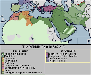
I love this 😀! I love that you included both themata and kleisoura for the ERE. Shouldn't Iberia and Abkhazia be vassals of the ERE? And what is the polity south of Armenia? And what happened to the Dalmatian cities?Here's the Middle East around 849 A.D.
Ah, shit, forgot to include the dalmatian cities, sorry.I love this 😀! I love that you included both themata and kleisoura for the ERE. Shouldn't Iberia and Abkhazia be vassals of the ERE? And what is the polity south of Armenia? And what happened to the Dalmatian cities?
The polity is Taron, one of the old Greater Armenian provinces which I believe are independent at this point.
Gotcha! I thought it might be Taron! A note however, Taron and Armenia would be held in union under Bagrat II who though recognized as ishkhan ishkhanats, by the Caliph, he was in open rebellion in 849 (being backed by several princes including the one in Vaspurakan). https://en.wikipedia.org/wiki/Bagrat_II_BagratuniAh, shit, forgot to include the dalmatian cities, sorry.
The polity is Taron, one of the old Greater Armenian provinces which I believe are independent at this point.
IDK if this is the right place to post althist, but i did a 1984-inspired TL after finishing reading the book
The thread is used mostly for patches or WorldA TL maps, but from what I've seen, I'm sure the others are fine with it.
IDK if this is the right place to post althist, but i did a 1984-inspired TL after finishing reading the book.
Anyone here willing to do a Western Roman Empire administrative divisions map?
After the split of Rome.
Does this work? I can edit out all the fanciness if that helps too
Share: