Crazy Boris
Banned
Been trying to find a 1519 map or a 1520 map, is there any that people know of?
I did 1521 a couple years ago
Been trying to find a 1519 map or a 1520 map, is there any that people know of?
Been trying to find a 1519 map or a 1520 map, is there any that people know of?
Here's a shortcut.This has not been updated in a while but this is basically that
Compilation of QBAM Historical Map stuff
docs.google.com

And Inca and their immediate neighbours that I found.
The maker says on the Coast of Venezuela and into Equador was the Sindaguas Confederacy. Not sure if they should be on the Northernmost coast of the map or if they should just off the map in Equador.
But you can read on them in Spanish wikipedia to be sure of borders.
https://www.persee.fr/doc/cea_0008-0055_1976_num_16_63_2519 Article about the babalia kingdom in chad (french)
https://www.persee.fr/doc/outre_0300-9513_1981_num_68_250_2313 Article about the Bedaya (sara) kingdom(s?) in chad (French)
Map of the sara homeland
Map of the sara homeland
Map of Sara kingdoms/subdivisions

3 from about that date + 1 slightly after - none are mineBeen trying to find a 1519 map or a 1520 map, is there any that people know of?
these are all useful, but would it be possible to link sources? i recognise the last one as a boris map3 from about that date + 1 slightly after - none are mine
View attachment 839152View attachment 839153View attachment 839154
View attachment 839155
Rest your cursor on them- the author is in their titlethese are all useful, but would it be possible to link sources? i recognise the last one as a boris map
i feel like i should've known that already given how long i've been using this site, but thank you for letting me know about that featureRest your cursor on them- the author is in their title
The border between Durham and Northumberland is missing. Again.
March 4, 1929: Herbert Hoover is inaugurated as US president
Nice. I most especially like the USSR borders. We've long lacked decent internal maps of the Russian SFSR before the late 30s, so this is much appreciated.
March 4, 1929: Herbert Hoover is inaugurated as US president
Because this problem seems to crop up again and again without being fixed, despite multiple alerts about it, here is the map of England with the border between Durham and Northumberland prior to 1974 filled in.The border between Durham and Northumberland is missing. Again.
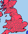


You'd figure that after so many times we would be over thisBecause this problem seems to crop up again and again without being fixed, despite multiple alerts about it, here is the map of England with the border between Durham and Northumberland prior to 1974 filled in.

Do we have a database for all of the Historical maps posted here? Trying to find one for the later 7th and 8th centuries

 docs.google.com
According to Wikipedia: "Legally, the countries (i.e. Denmark, Sweden, and Norway) remained separate sovereign states. However, their domestic and foreign policies were directed by a common monarch."Should we put the Kalmar Union as a singular state, similar to Austria Hungary, or keep them separate and represent it in some other way?
Maybe show the borders but have color shading to mark the union? I dunno.Should we put the Kalmar Union as a singular state, similar to Austria Hungary, or keep them separate and represent it in some other way?
The Austro-Hungarian Compromise also stablished that "Austria and Hungary do not form a common sovereign territory in international law. (Ie. Kingdom of Hungary and Empire of Austria were different countries) Thus regarding to [...] peace treaties, the Empire of Austria and Kingdom of Hungary had to act independently as independent countries" + the "dual monarchy" consisted of the Emperor-King, and the common ministers of foreign affairs, defence, and a finance ministry only for expenditures of the Common Army.According to Wikipedia: "Legally, the countries (i.e. Denmark, Sweden, and Norway) remained separate sovereign states. However, their domestic and foreign policies were directed by a common monarch."
The Austro-Hungarian Compromise also stablished that "Austria and Hungary do not form a common sovereign territory in international law. (Ie. Kingdom of Hungary and Empire of Austria were different countries) Thus regarding to [...] peace treaties, the Empire of Austria and Kingdom of Hungary had to act independently as independent countries" + the "dual monarchy" consisted of the Emperor-King, and the common ministers of foreign affairs, defence, and a finance ministry only for expenditures of the Common Army.
According to Wikipedia: "Legally, the countries (i.e. Denmark, Sweden, and Norway) remained separate sovereign states. However, their domestic and foreign policies were directed by a common monarch."
Maybe show the borders but have color shading to mark the union? I dunno.
The Austro-Hungarian Compromise also stablished that "Austria and Hungary do not form a common sovereign territory in international law. (Ie. Kingdom of Hungary and Empire of Austria were different countries) Thus regarding to [...] peace treaties, the Empire of Austria and Kingdom of Hungary had to act independently as independent countries" + the "dual monarchy" consisted of the Emperor-King, and the common ministers of foreign affairs, defence, and a finance ministry only for expenditures of the Common Army.
With all that said, where do we draw the line in them being 1 entity and 2 entities in a personal union? I'm also thinking about other states such as Poland and Lithuania between 1386-1526, the UK of Great Britain (before they added Ireland), pre-1707 Spain, the Soviet Union, and any other states that this would apply toAH was a dual monarchy, not a personal union. Austria and Hungary were effectively two largely self-governing parts of a single state, but still had a shared administration in some areas, whereas the three kingdoms of the Kalmar Union had no institutions in common except their three (legally distinct) crowns just happening to (usually) be shared by the same king.