Map Thread XVIII

Status
Not open for further replies.
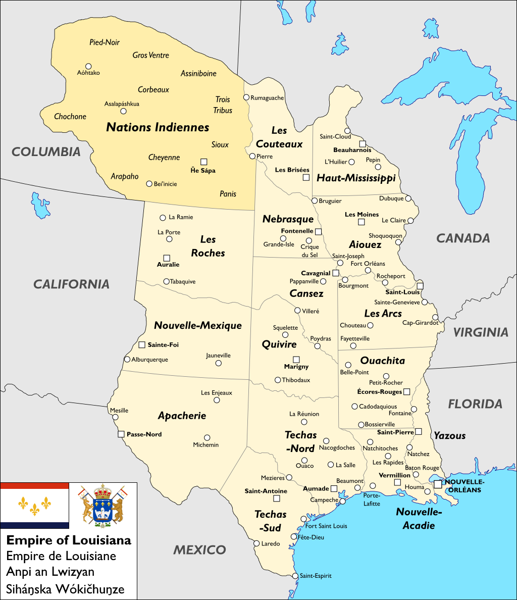
From Another America:

dczmdqf-62b94a3e-0264-417b-8c89-5a20ad7cf39b.png


Louisiana was first settled as a French colony in 1699, with the capital of Nouvelle Orleans being founded in 1718. Lower Louisiana developed a plantation economy, importing large numbers of African slaves, while the economy of more sparsely settled Upper Louisiana revolved around the fur trade with indigenous peoples. Throughout the century France managed to hold on to Louisiana through a number colonial wars - one effect of these wars was the migration to Louisiana of a large number of Acadian settlers expelled by the British, who would become known as Cajuns and have a major influence on Louisiana’s culture.

Louisiana first declared independence as a republic in the 1790s alongside the French Revolution, but after a few years and an unsuccessful attempt to unite its fellow revolutionary republic in Canada, Louisiana was occupied and the First Republic was overturned by French royalists (many of them part of an influx of planters and their slaves fleeing the Haitian Revolution) and placed under primarily Spanish occupation for the next two decades, leaving notable Caribbean and Spanish imprints on Louisianan culture. The royalist forces also attempted unsuccessfully to invade Canada in a series of clashes that defined the current border at the Mississippi River.

Following the defeat of Napoleon and Bourbon restoration in 1815, the rival Orleanist claimant Louis-Philippe was exiled to Louisiana, where local elites, chafing under the occupation and inspired by the wave of revolutions and wars of independence sweeping across the Americas, invited him to take the Louisianan throne and declared independence as the Empire of Louisiana, which with Mexican and Canadian support won a brief war of independence against a Franco-Spanish coalition.

The First Empire was dominated by the Creole planter elites (much to the chagrin of the Cajun yeomanry, not to mention their slaves) and particularly preoccupied with the issues of northward and westward expansion (successfully conquering Techas, by then mostly populated by Cajun settlers, from Mexico in the 1830s) and of slavery, which was the bedrock of the Louisianan economy but grew increasingly untenable as time went on and was gradually and fitfully abolished by the 1870s, with the liberally-inclined monarchy being one of the main drivers of abolitionism.

In the 1880s Louisiana joined Canada and the United Provinces in fighting the British Empire. Louisiana fought primarily on the Great Plains and was victorious in fending off the British on that front (in recognition of which its Indian allies such as the Sioux were granted lasting autonomy) although it failed to press its claims extending to the Pacific coast. The war was highly expensive and something a fiasco, revealing the underequipped and unprepared state of the military, with a sense that the monarchy was reluctant to support the military, frustrating many officers. Soon after the war, these military officers joined with the planter elites still dissatisfied over the abolition of slavery in a military coup, forcing the Emperor to abdicate and establishing the Second Republic.

The Second Republic was oligarchic in nature, dominated by planting and ranching (cattle drives having become prominent) interests and the military, and highly politically and economically unstable, especially in the 1920s as a result of the revolution in neighboring Florida. In 1928 the charismatic populist Hubert Long was elected president and quickly set about establishing a dictatorial regime with the support of the military. Long was skilled at appealing to and playing off all sides of the political spectrum and remains a controversial figure in Louisiana today, with his successes at economic development and establishing a welfare state weighed against his sometimes brutal suppression of dissent and democracy.

Long was assassinated in 1961, ushering in the era of the Third Republic, defined by a power vacuum and resumed political and economic chaos as different factions fought over what the new Louisiana should look like - whether it should be a liberal republic, socialist republic, monarchy, or military regime, the role of the Church, the status of black and indigenous people, economic redistribution, foreign relations, and a myriad of other conflicts exacerbated significantly by the civil war in neighboring Virginia, the effects of which brought Louisiana to the brink of civil war in the May 1968 crisis as well as to the brink of war with Florida.

During this time Henri d’Orleans, pretender to the imperial throne, emerged as a moderate unifying figure with appeal across the political figure. He is widely seen as pioneering the Grand Compromise of 1975: Henri would resume the throne as emperor in a democratic constitutional monarchy defined by federalism, racial equality, neoliberal economics, protection but not hegemony for the Catholic Church, and participation in North American integration. Thusly the Third Republic became the Second Empire. (Another effect of the new constitution was the quilt of autonomous native territories becoming united and formally organized as the Nations Indiennes.)

Since the restoration of the monarchy Louisiana has enjoyed an economic boom fuelled largely by oil, bringing it to parity with the other nations of North America, although inequality remains a major issue with much of the new wealth concentrated in a few hands (corruption scandals are frequent). It is still more religiously pious than the rest of North America, with a large Catholic majority, although secularism is increasing and this tension has become a major social issue. Louisiana is also regarded as having a particularly rich and vibrant culture, based on a French, African, and indigenous base with influence from successive waves of Haitian, Spanish, German, Irish, Scandinavian, Italian, Mexican, Floridian, and Vietnamese immigrants, with its cuisine, music, festivals, and more being influential across the Americas and the world. Much of this energy has come from cultural revival movements among minorities - for the Creole language and Vodun religion among Afro-Louisianans, especially in the black-majority province of Yazous, and for native languages, religions, and customs among indigenous peoples, many of whom have been empowered by recent oil discoveries in their lands. Louisiana is a full member of the North American Community and widely considered to be a rising power within that bloc.
 
Last edited:

Deleted member 101966

Still hard at work on the OTL project I've named after a 90s tourism slogan: Alberta, in all her majesty. Here are some more excerpts for style and quality:

unknown.png


A particularly complex area of backwoods county boundaries, protected lands, and historical Métis settlements.

unknown.png


Grassland landscapes, a UNESCO World Heritage Site, and a provincial park whose name goes on for far too long.

unknown.png


The Coal Branch, a mostly-abandoned cultural region at the edge of the Rockies. Ghost towns and ATV tracks abound in equal measure.

(The less said about the file size of the full thing, the better.)
 

Attachments

  • upload_2019-2-13_0-47-40.png
    upload_2019-2-13_0-47-40.png
    488.8 KB · Views: 281
Last edited by a moderator:
dczmdqf-62b94a3e-0264-417b-8c89-5a20ad7cf39b.png


Louisiana was first settled as a French colony in 1699, with the capital of Nouvelle Orleans being founded in 1718. Lower Louisiana developed a plantation economy, importing large numbers of African slaves, while the economy of more sparsely settled Upper Louisiana revolved around the fur trade with indigenous peoples. Throughout the century France managed to hold on to Louisiana through a number colonial wars - one effect of these wars was the migration to Louisiana of a large number of Acadian settlers expelled by the British, who would become known as Cajuns and have a major influence on Louisiana’s culture.
Ooooooh dear. What happened to the Natives in Florida and Virginia? They get enslaved, shipped off to the Caribbean to trade for Africans (like they did early on around the Colonies) or did something like the Five Civilized Tribes came about, and whoever was in charge of Florida was happy to have large groups of people mimicking them, as well as guarding the borders?
 
Ooooooh dear. What happened to the Natives in Florida and Virginia? They get enslaved, shipped off to the Caribbean to trade for Africans (like they did early on around the Colonies) or did something like the Five Civilized Tribes came about, and whoever was in charge of Florida was happy to have large groups of people mimicking them, as well as guarding the borders?

That's exactly what happened in Florida, this map is kind of outdated but shows the basic setup, the Civilized Tribes as autonomous regions guarding Florida's borders. In Virginia, the natives west of the Appalachians were pushed into Florida, and the natives east of the Appalachians faced a similar fate as in OTL of either dying out or dwindling to very small numbers with some exceptions like the Lumbee.
 
global warming.png

An old map that I have just found going through my map folder. Wanted to post it.
kind of a post all ice melting cold war 2.0 with the West against BRICS+Iran. Cant say much there is USA, United Commonwealth, European Federation and their allies on the blue corner. Non-communist Eurasian Union, its satellites in brown; good old PRC and allies in red and pink; India in orange and its sphere in gold; United States of Southern Africa in yellow and Congress of African Nations in beige; Brasil in purple and crew in lavender; Iran in green and associates in light green in the multicolored corner. Also some grey neutrals in Africa. India and Brasil are corporatist and technocratic I think. Not sure about Africans.

A vs FG 1.png

Something I was working on around the summer of 2017. Main part of it was going to be Albion (British Empire) vs Franco-Germania. Since when I was thinking on I thought of it as a simple, not much thought on it lazy scenerio you could find in a video game sort of thing. I don't remember from where the goddamn surviving Mongol Empire and partition of Mexico came from however. Mediterranian Union and Dar-al-Islam also sort of came from nowhere. I think I will try to remaster this map/timeline sometime later.
 
Last edited:
Haut-Mississippi
Absolutely HUGE Mississippi, astounded at the size of that lad

Also, I know that it follows a major river so its not that unlikely a border to be created, but it still bugs me to see the modern Texas border pop up in timelines with a really different North America.

Grassland landscapes, a UNESCO World Heritage Site, and a provincial park whose name goes on for far too long.
He he, dinosaur pp, he he
 
View attachment 440362
An old map that I have just found going through my map folder. Wanted to post it.
kind of a post all ice melting cold war 2.0 with the West against BRICS+Iran. Cant say much there is USA, United Commonwealth, European Federation and their allies on the blue corner. Non-communist Eurasian Union, its satellites in brown; good old PRC and allies in red and pink; India in orange and its sphere in gold; United States of Southern Africa in yellow and Congress of African Nations in beige; Brasil in purple and crew in lavender; Iran in green and associates in light green in the multivolored corner. Also some grey neutrals in Africa. India and Brasil are corporatist and technocratic I think. Not sure about Africans.
Ahhh yes, quite old. I rememeber on DeviantArt some years back of how Hungary was shown as flooded. I am unsure if it is possible, given it is so far inland, though I suppose water might wrap around from the Mediterranean and Black Sea before pouring up the Danube Basin. Though I assume that river mostly goes downhill, so... actually reminds me how apparently sea level is different on each side of the Panama Canal. So many about geography I still don't know. And I really will need to look through my external hard drive. While I have very few maps I made myself, I think I once collected a couple dozen when I was going through the old map threads on here. So many excellent maps lost as image hosting sites went out of business. Or so I assume. But yah, I am guessing this map was back before people on here stopped having Hungary flooded when ocean rises came, but before the maps showing Greenland without the glaciers was popularized.

On a side note, does anyone know if there is a thread on here collecting maps showing the crawl sea levels rising or falling?
 
Ahhh yes, quite old. I rememeber on DeviantArt some years back of how Hungary was shown as flooded. I am unsure if it is possible, given it is so far inland, though I suppose water might wrap around from the Mediterranean and Black Sea before pouring up the Danube Basin. Though I assume that river mostly goes downhill, so... actually reminds me how apparently sea level is different on each side of the Panama Canal. So many about geography I still don't know. And I really will need to look through my external hard drive. While I have very few maps I made myself, I think I once collected a couple dozen when I was going through the old map threads on here. So many excellent maps lost as image hosting sites went out of business. Or so I assume. But yah, I am guessing this map was back before people on here stopped having Hungary flooded when ocean rises came, but before the maps showing Greenland without the glaciers was popularized.

Well it was before South Sudan and (little bit) later than Kosovo thats for sure. Since base map didn't have either of them but I did try to draw Kosovo in there.
 

This is amazing, I love it.

Could you tell us more of this world?

Even if House of Orleans was in exile over here, the Bourbons back in France where almost doomed from the start. Louis XVIII at least understood a return to 1789 was impossible and his rule was all about trying to find a balance, and at least accepting or tolerating of the reality of the Revolution. (While others went basically in "lalalalala I can't hear you" mode) Charles X was a idiot who tired to turn back the clock and act like the Revolution never happen. Which cost him and the Bourbons France for good.

What does the rest of North America look like?
 
View attachment 440362
An old map that I have just found going through my map folder. Wanted to post it.
kind of a post all ice melting cold war 2.0 with the West against BRICS+Iran. Cant say much there is USA, United Commonwealth, European Federation and their allies on the blue corner. Non-communist Eurasian Union, its satellites in brown; good old PRC and allies in red and pink; India in orange and its sphere in gold; United States of Southern Africa in yellow and Congress of African Nations in beige; Brasil in purple and crew in lavender; Iran in green and associates in light green in the multivolored corner. Also some grey neutrals in Africa. India and Brasil are corporatist and technocratic I think. Not sure about Africans.

View attachment 440363
Something I was working on around the summer of 2017. Main part of it was going to be Albion (British Empire) vs Franco-Germania. Since when I was thinking on I thought of it as a simple, not much thought on it lazy scenerio you could find in a video game sort of thing. I don't remember from where the goddamn surviving Mongol Empire and partition of Mexico came from however. Mediterranian Union and Dar-al-Islam also sort of came from nowhere. I think I will try to remaster this map/timeline sometime later.
The two powers are reunited! Charlemagne will rest easy in his grave.
 
We all "know" that the Portuguese, from Gil Eannes through to Vasco Da Gama, explored the coasts of Western and then Eastern Africa, and, of course, that Bartholomew Diaz was the first to discover and round the Cape of Good Hope in 1488.

However, the 14th century Chinese cartographers, Chu Su-Pen and Lo Hung-Hsien, drew maps, actually much better than Ptolemy’s world atlas, showing the coastline of eastern and southern Africa, presumably from a Chinese voyage in the Indian Ocean in the 14th century.

From further Chinese explorations of coastlines of East Africa, including the voyages of Admiral Zheng He in the Indian Ocean, Ch’uan Chin and Li Hui created detailed maps these areas in 1401. Zheng He was a Chinese Muslim who sailed through the Indian Ocean and down the coast of East Africa. On a map made in 1402, called Kangnido by Chinese mapmakers, the southern and south western coastline of Africa is shown in detail.

In the West, the 1425 Portolano Laurenziano, from Genoa, shows, for the first time, the correct outlines of the north, west, east and southern coasts of Africa as well as tolerably accurate positions of rivers such as the Congo and the Niger. It shows the circular shape of the South African coastline. This was over 50 years before Bartholomew Diaz' voyage of 1488.
A Portolan is a map specifically designed for navigation, showing navigation aids for the coastlines but little in the way of internal geography beyond that.
The Venetian Albertinus De Virga world map of 1415 also shows the whole African outline in detail.
The source for the Portolano Laurenziano Gaddiano map was possibly from Niccolò de' Conti's travels in the Indian Ocean with Admiral Zheng He.

A 1351 Genoese map shows the whole African outline before the 1402 Chinese map. There is speculation that the map was based on early Genoese explorers of sub-Saharan Africa from the West to the south coast. The texts used in the maps show they had to have been made after explorers had been there. This is the earliest evidence of Genoese explorers in West Africa.

Antonio Uso di Mare (or Antoniotto Ususmaris), the Genoese, after accompanying Cadamosto in the 1450s to West Africa, wrote a letter of the 12th of December 1455 recording a meeting with the last surviving descendant of a Genoese expedition of 1291.


The Knights Templar operated in Portugal as early as 1128. A native order was founded in Portugal about 1146. Afonso gave to it the town of Évora, captured from the Moors in 1166, and the Knights were first called "Friars of Santa Maria of Évora".
After the conquest of Aviz a castle erected there became the mother-house of the order, and they were then called "Knights of St. Benedict of Aviz"
badge 2.png


The anti-Templar movement, based in France, had little effect in Portugal but when the Order was officially dissolved by Pope Clement V in 1312, its knights, servants and monks were considered outlaws.
King Denis of Portugal exonerated the Templars but, after pressure and opposition to the Order from France, came up with a plan which would benefit to both the King and Templars.

The Order of the Knights Templar disappeared to be re-established under a new name, affiliated to the Portuguese monarchy. Templar assets would not fall into Church hands, and they could continue to exist. The Order of the Knights Templar rose again as the Order of Christ, no longer abiding by church rules.
badge 1.png


With this Portuguese support the “mystery” of where the Templar treasures went is probably a little clearer. Much of it's disposable specie invested in the Order of Christ's new headquarters at Tomar. The recognition of the Order by the church, in 1319, was seen as a cynical attempt by the Pope to regain their services and treasures.

To avoid this, in 1336, under the auspices of a Portuguese expedition, the Canary Islands were rediscovered. Whilst the Portuguese made no attempt to colonize the islands, the Order established a base. In reality the expedition probably used maps from the 1270 voyage of Lancelot Malocello, a Genovese explorer. The first explorer of the Middle Ages to sail past the coast of Morocco.

By 1339 naval charts show the Canary Islands correctly and the Order looked to move on, especially as, in 1344, Pope Clement VI (using a Papal Bull, Tu devonitis sinceritas) granted Luis de la Cerda the title "Prince of Fortunate Islands" and sent him to conquer the Canary Islands for Christianity. He was a royal prince of Castile.

The opposing claims led to war. The Battle of Aljubarrota in 1385 won by Portuguese, led by the Order of Christ and the Order of Aviz, by now almost one and the same, ensured Spain would not try to seize Portuguese discoveries by force. But this did not apply to the Canary Islands. Portuguese interest turned to other islands such as the Azores, Madeira, and Cape Verde islands whilst the Orders moved on.

No firm information is available for their early travels but it is understood that the ease of Portuguese dealings in the Benin[1472] and Kongo[1483] Kingdoms were due to their previous contacts with the Orders.

The ease of Portuguese acceptance in the Indian Ocean was due to the presence of existing trade contacts with Order bases and colonies.
Isola de San Lorenzo C.png

Templar Africa trade sm4 by Bob Hope.png
 
Ahhh yes, quite old. I rememeber on DeviantArt some years back of how Hungary was shown as flooded. I am unsure if it is possible, given it is so far inland, though I suppose water might wrap around from the Mediterranean and Black Sea before pouring up the Danube Basin. Though I assume that river mostly goes downhill, so... actually reminds me how apparently sea level is different on each side of the Panama Canal. So many about geography I still don't know. And I really will need to look through my external hard drive. While I have very few maps I made myself, I think I once collected a couple dozen when I was going through the old map threads on here. So many excellent maps lost as image hosting sites went out of business. Or so I assume. But yah, I am guessing this map was back before people on here stopped having Hungary flooded when ocean rises came, but before the maps showing Greenland without the glaciers was popularized.

On a side note, does anyone know if there is a thread on here collecting maps showing the crawl sea levels rising or falling?
Hungary actually is at quite a low elevation. In Budapest, for instance, the Danube is about 100 meters above sea level. Now, ocean flooding to that level (disregarding great thermal expansion) would take more water than we actually have on the surface of the Earth, so it's not likely to happen. Even if it did, the connection from this Pannonian Sea to the Black Sea would run through the very constricted Danube Gorge, so I expect Hungary would silt back above sea level without too much trouble.
 
The Final (final as in I will not modify/add any landmasses further) version of my Alternate Strangereal Earth map intended for my roleplay. The lore still the same. Check it out here.
AltStrangerealFinalVersionDetailed.png


And here's the current situation of the world in my ongoing roleplay with my friends (on my Discord server) in the year 2023.
AltStrangerealFinalVersion_2023.png

On February 2nd 2023 AD, The People's Republic of Verusa invaded the continent of Asetralia, taking 65% of all the landmass and occupy it in a single thrust strike in just several hours after the PLA Navy and Air Force bombarded the IUN bases as well as several nations bases, Some of it belong to Osea which crippled most of the oil supplies and naval warships that stationed there.

The Verusan view this war as a war of liberation, as they claim the invasion was to liberate the Verusan people from the "bourgeois capitalist tyranny" of the Gansu regime as well as taking revenge on the Wanian for their past crime against their people during the Asetralian-Usean War (1941-1945).

The Commonwealth of Asetralia immediately impose the martial law in their country and arrest every Verusan-descent citizen and sent them to the interment camp for fear that one of them are potential PRV sympathizers. The Gansuan put a fierce resistance against their leftist brethren from Verusa. While the Asadal barely hold their last major city, Kaechon from the onslaught.

EDIT: Also a bonus, a possible 19th Geopolitical Map of Strangereal.
AltStrangerealFinalVersion_1885.png
 
Last edited:
dczmdqf-62b94a3e-0264-417b-8c89-5a20ad7cf39b.png


Louisiana was first settled as a French colony in 1699, with the capital of Nouvelle Orleans being founded in 1718...

Hi, nice map and TL.
A little corretion, unless you have good reasons to back alternate spelling :
Nouveau-Mexique and Choquoquon...
Indeed Mexique is masculin and Sh does not exist in standard French spelling.
CU
 
View attachment 440362
An old map that I have just found going through my map folder. Wanted to post it.
kind of a post all ice melting cold war 2.0 with the West against BRICS+Iran. Cant say much there is USA, United Commonwealth, European Federation and their allies on the blue corner. Non-communist Eurasian Union, its satellites in brown; good old PRC and allies in red and pink; India in orange and its sphere in gold; United States of Southern Africa in yellow and Congress of African Nations in beige; Brasil in purple and crew in lavender; Iran in green and associates in light green in the multivolored corner. Also some grey neutrals in Africa. India and Brasil are corporatist and technocratic I think. Not sure about Africans.

View attachment 440363
Something I was working on around the summer of 2017. Main part of it was going to be Albion (British Empire) vs Franco-Germania. Since when I was thinking on I thought of it as a simple, not much thought on it lazy scenerio you could find in a video game sort of thing. I don't remember from where the goddamn surviving Mongol Empire and partition of Mexico came from however. Mediterranian Union and Dar-al-Islam also sort of came from nowhere. I think I will try to remaster this map/timeline sometime later.

That first one gives me serious flashbacks to some of my own first maps.
 
This is amazing, I love it.

Could you tell us more of this world?

Even if House of Orleans was in exile over here, the Bourbons back in France where almost doomed from the start. Louis XVIII at least understood a return to 1789 was impossible and his rule was all about trying to find a balance, and at least accepting or tolerating of the reality of the Revolution. (While others went basically in "lalalalala I can't hear you" mode) Charles X was a idiot who tired to turn back the clock and act like the Revolution never happen. Which cost him and the Bourbons France for good.

What does the rest of North America look like?

Thanks!

North America, the world.

Yep, as in OTL the Bourbon Restoration was not ultimately successful in this world. I am thinking that French politics became more in extreme in this timeline than in OTL, culminating in a *Boulangist regime taking over and then getting beaten down in *WW2, and I think lacking the Orleanists as a relatively liberal/moderate monarchist option would contribute to that kind of polarization.

Hi, nice map and TL.
A little corretion, unless you have good reasons to back alternate spelling :
Nouveau-Mexique and Choquoquon...
Indeed Mexique is masculin and Sh does not exist in standard French spelling.
CU

Noted, thanks.
 
We all "know" that the Portuguese, from Gil Eannes through to Vasco Da Gama, explored the coasts of Western and then Eastern Africa, and, of course, that Bartholomew Diaz was the first to discover and round the Cape of Good Hope in 1488.
...
Nice map, Bob Hope! :)
I have a few corrections to suggest: (I'm also going to give suggestions regarding archaic spelling)
Where it is Bartholomew Diaz, it should be Bartholomeu Dias (in the modern spelling, it would be Bartolomeu Dias);
Likewise, Gil Eannes is correct for an archaic spelling (it would be Gil Eanes in a modern spelling);
Where it is Vasco Da Gama, it should be Vasco da Gama;
Where it is Lorenco Marques, it should be Lourenço Marques;
Where it is Quilimane, it should be Quelimane;
Where it is Tomar do Sud, it should be Tomar do Sul;
Where it is Isola de San Lorenzo, it should be Ilha de São Lourenço.
 
Top
Status
Not open for further replies.
Top