Map Thread XVII

Status
Not open for further replies.

Gian

Banned
earths_and_the_ark_by_brentatticus-dchjs0m.png

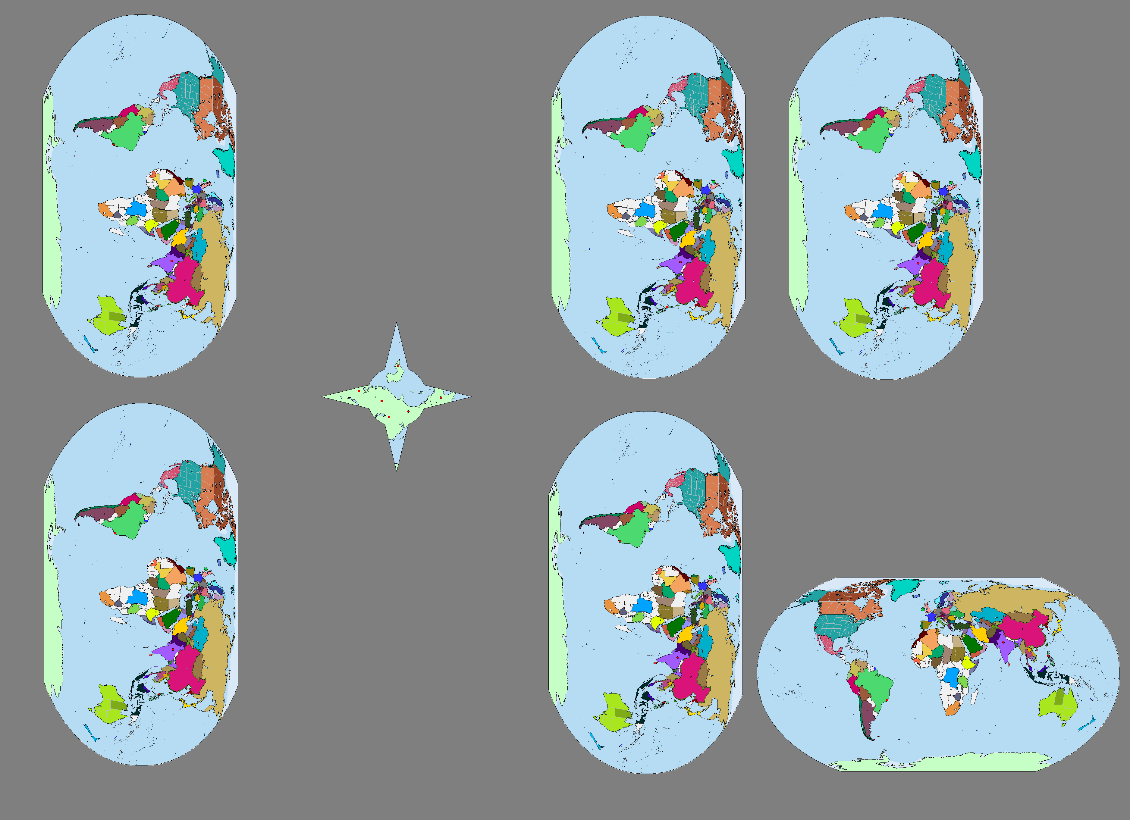
On November 26, 2017, portals that are circular in shape with a radius of 10 meters opened in Manila, Delhi, Rio de Janeiro, and San Francisco with one portal in each city. The portals led to a space station in the middle of deep space similar to the 'Ark' or 'Installation 00' in Halo but having only four arms.

But our world is not the only one that had portal access to this massive construct. Five other worlds have portal access to the 'Ark', Earths different from ours. The other Earths seem to be the same as ours in both history and people, but there actually is a difference.

In our world BrentAtticus chose to eat in KFC in November 26, in the others he chose McDonald's, Shakey's, Jollibee, Wendy's, and not eat at all.

Note: The arrangement of the Earths in the map have no meaning at all.

I don't get it.

What's the point?
 
British North Atlantis.png


In this world, England was never unified, and was and is primary divided between the Kingdoms of Wessex in the south and Northumbria in the north who both managed to swallow their regional neighbors but never each other. Wessex and Northumbria both established North American colonies, naturally right next to each other, so the rivalry between Wessex colonized Nova Londinium and the Northumbria colonized New Yorkshire mirrors the division of England itself.

New Yorkshire, which in a deliberate coincidence is the exact same area as OTL New York State, is ruled from the colossal metropolis of New York City. Within and outside of The City, the details are unrecognizable from our New York State - for example there are no Dutch derived names anywhere, and of course The City is the actual capital - but the core trend of the rest of the nation acting as The City's backyard remains.

Nova Londinium is ruled from Downing, in the same place as OTL Boston, which doesn't have nearly the same power as NYC allowing smaller cities like Bachester and Haven Rock to become notable within the country. Also deliberately similar in area to OTL New England, minus Housaton and a slice of ![Maine].

The two nations have fought several wars with each other, such as the Green Mountain War in which Nova Londinium support a rebellion that led to their conquest of ![Vermont]. The most recent war (the last, as we all hope) was a New Yorkshire victory. New Guernsey, which was on Nova Londinium's side, has avoided losing territory, but in exchange has become political and militarily neutralized and is nowadays economically dependent on their former enemies. The Republic of Housaton was created, out of the territory disputed in the war - New Yorkshire didn't do enough to actually annex it, but has successfully prevented Nova Londinium from taking it back.

New Guernsey was an effort to create a "pan-English" state in the Atlantines, named after the island that agreed to shelter the Utopian founder and his merry band from Wessex authorities. The project was a total failure, not because nobody settled there, but because the colony attracted so many Welsh, Cornish, Breton, Scottish, and Irish settlers that they became the dominant group of the colony and the English settlers preferred one of the two main colonies. Today it is a "pan-Northwest European" state, although tensions exist involving the current wave of Irish economic migrants.

Housaton is only now discovering their own national identity and culture beyond simply being a small buffer state. A fairly elitist place.

To the south of New Yorkshire (and west of New Guernsey) is the powerhouse of North Atlantis, the Dutch speaking Atlantine Federation of Republics. One of the few things British North Atantines can agree on besides the roundness of Earth and the hotness of the Sun is that the AFR are arrogant and overbearing as they always threaten to sail "peacekeeping" ships northwards whenever the two main powers so much as enter a shouting match. Seen as well meaning by most, in the end.
 
upload_2018-7-19_11-30-20.png


Hello, this is a map of Poland in 1145. The POD is that the King Boleslas II is not overthroned by his brother, who dies during a hunting accident in 1068 without heir. This provides the kingdom with both stability, since there is no other pretender to the crown than the King himself and his young son Vladislav, who will become Vladislav the Bold. The new stability of the Kingdom will lead to the conquest of the pagan tribes, conquering the Baltic coast. Several cities were turned into Republics to increase the influence of Poland and fight against the merchants and pirates of Gotland. After several conquests, the King created the Great Council of Poland, based on the Venician model, where every literate person could ask a seat and get one.

After his death, the throne was taken by his son, who choosed to continue his father's expansion, but turned to the North-East, against the Balts. He will create the Strong Duchy of Mazovia-Lithuania to administrate the Eastern Poland and protect it against any attack from the Ruthenians during the conquest of Lithuania, that will take a half century and be finished by his son the Duke Pelka of Pecs when he would be crowned King of Poland, King of Lithuania, and Emperor of the One Royal Crown.

The most complicated part of the Crown is when it comes to the administration the three Kings built to rule this messy Kingdom. The Great Council was extended to the whole Empire, but it's new size makes it complicated to manage. The distinction between the Kingdoms of Lithuania and Poland is almost purely nominal, and is mostly kept for prestige and some stuff with the Pope, who accepted that the King of Poland makes of the Archibishop of Ruthenia the leader of the Order of Ruthenia, created to convert pagans and orthodox. The Duchy of Mazovia Lithuania was split between the two childern of the Duchess Jadwiga, and the status of the Duchy of Pecs, still officially Hungarian, is ambiguous to say the least.
 
I believe it has something to do with how surreal it is: a gaming webcomic (a rather mediocre one at that, too), that has a sudden arc about one of the characters have a miscarriage.
That's what the joke was originally - the subject of the comic - but the joke now is just the joke itself. It's "funny" because it's an in-joke/reference; the Loss meme is just someone putting in the layout from my previous post and then you, the viewer, recognising that layout and groaning because of it.

If the joke was still about the abortion from CAD, then stuff like 'minimalist loss' or even the shitpost-map everyone is complaining about wouldn't even exist; they have no connection to the topic, they just have the layout of
I II​
II I_​

Anyway, this is the map thread not the meme thread so lets just move on from it.
 
these modern-like borders drive me crazy
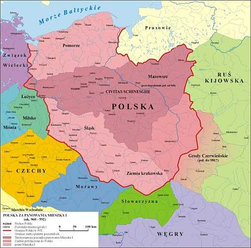
mieszko%20I%20mapa.jpg

this is poland in 10th century if thats what u had in mind
not gonna comment on fitting of this description in medieval polish setting

I don't get it, is my map good or bad ? (And sorry for using modern subdivisions, it's the limits of mapchart, even though I tried to improve a bit my map on paint I'm working with very limited tools so, yeah, I started from the Crusader Kings II 1066 Poland, since Paradox is hard working concerning accuracy, and I did what I could ...
 
sdei60t9mwa11.png


Thousand Week Reich - Iraq Jordan Israel-Palestine Economic Community, 1958

Hi! This is a map that was commisionned by u/TheNoobArser

, he made the lore and i drew the map.

Rest of the scenario -https://www.reddit.com/r/AP246/comments/7ch604/the_thousandweek_reich_a_realistic_nazi_victory/

And its HOI4 mod in development - https://www.reddit.com/r/twrmod/

Discord (for the mod)- https://discord.gg/7Zyc8RM

Timeline thread: https://www.alternatehistory.com/fo...ich-a-realistic-nazi-victory-scenario.444582/


Some context by /u/ap246

Syria

Israel-Palestine

After the stabilization of the Israeli-Palestinian Confederation in the aftermath of the Israeli-Palestinian–Syrian war there was an economic boom fueled by Western investment and aid, and also by Jewish aliyah. Jordan, which was eyeing up Palestine in the early fifties, was blocked from trade with Syria, so reluctantly it normalized relations with the Israeli-Palestinian Confederation and has signed several trade and border treaties with it. Not long after, the parties signed the Treaty Establishing the Jordan–Israel-Palestine Economic Community, also known as the treaty of Jerusalem, which established a common market in the afromentioned countries. Later Iraq also joined, because many of its traditional trade partners were now hostile.

And a link to my new deviantart Gallery
 
I don't get it, is my map good or bad ? (And sorry for using modern subdivisions, it's the limits of mapchart, even though I tried to improve a bit my map on paint I'm working with very limited tools so, yeah, I started from the Crusader Kings II 1066 Poland, since Paradox is hard working concerning accuracy, and I did what I could ...
A lot of people on here hate it when modern borders are used (without a good reason, that is) because on one hand they are not properly representing what you want to show (unless set in modern time), and on the other, in the last 15 or-so years in which this forum has existed, a lot of people have used hideous modern day borders, especially in maps that suit the genre of this website, alternate history, with the PoD being far too early for this border to possibly exist. Of course, There can always be a coincidence that borders are the same but it's incredibly difficult to explain why. Back in the 1200s for example we were far from the borders used in modern times, especially the post-WW1 prussia boundary or the Soviet post-ww2 Curzon line "thingy".
...It's kinda like killing Von Braun in the 1920s and expecting America to fly to the Moon with a Saturn V in 1969, just with borders.

However I think since you are a beginner, you'll be likely forgiven. :)
 
I don't get it, is my map good or bad ? (And sorry for using modern subdivisions, it's the limits of mapchart, even though I tried to improve a bit my map on paint I'm working with very limited tools so, yeah, I started from the Crusader Kings II 1066 Poland, since Paradox is hard working concerning accuracy, and I did what I could ...
As Valdore Javorsky said, this isn't the first, nor will it be the last. I have made far, far worse inaccuracies than this in the past (although I think I removed most of the worst case offenders from existence). Every once and a while, I still end up throwing in a modern border where it doesn't belong.

Also, as a side note, while Paradox tries to be fairly accurate, there are time where it hasn't, most notably in Poland and Lithuania in CKII, but those areas will be updated here soon. I recommend that make perhaps you redo this when that comes out if you want to be more accurate.

But, nonetheless, keep on improving!
 
Top
Status
Not open for further replies.
Top