Just a quick question: I've seen that basemap in a thousand and one different styles, with a thousand and one different borders, but is there a single, definitive, original basemap from which all these other maps have been drawn?
You are using an out of date browser. It may not display this or other websites correctly.
You should upgrade or use an alternative browser.
You should upgrade or use an alternative browser.
Map Thread IV
- Thread starter Ian the Admin
- Start date
- Status
- Not open for further replies.
correct..but all that Russian growth was from 1945-1991 cause of the evil Soviet colonization programs..and Deportations of the Baltic ethnic groups...have to love the Soviets' nation building policies in Siberia
interestingly, if the baltic states are taken as a whole then russians are pretty are the majority, because the make (or made at the fall of the USSR) nearly 50% of the population in each of the SSRs
Teal: Democratic Republic of New England
Purple: Republic of Texas
Red: USA
Blue: CSA
Pink: New Christian League
Sky Blue: Conch Federation
Brown: FISA (Free and Independent State of Alaska)
Gray: Anasazi
Orange: New Deseret
Yellow: Union of Californian City-States
Green: Empire of Cascadia
Ligh Purple: Kingdom of Hawaii
What do ya think?
i like. but the Jpeg ruined it. save things as PNG in the future.
'Is that land in black ?
I'm wondering if the Tsars would have gained more then Alaska if they could have gone by foot from Siberia to North America... Imagine not only soviet Alaska but Soviet Canada !!!
um... the Soviets never had Alaska.

Teal: Democratic Republic of New England
Purple: Republic of Texas
Red: USA
Blue: CSA
Pink: New Christian League
Sky Blue: Conch Federation
Brown: FISA (Free and Independent State of Alaska)
Gray: Anasazi
Orange: New Deseret
Yellow: Union of Californian City-States
Green: Empire of Cascadia
Ligh Purple: Kingdom of Hawaii
What do ya think?
head over to my maps in the first half of the "Well, it seems like the Second American Civil War is in full swing..." (or whatever the absurdly long title was) thread. I quit after a while because thecreeper was acting really immature over my independent Mihigan+Chicago area
um... the Soviets never had Alaska.
Tsar = Russian Emperor. he means if the Romanovs had gained more land/control in Alaska, then the SOVIETS, who succeeded the Romanovs, would have been able to gain control of Alaska and Canada.
Nations based on drainage basins?
Very cool and very nice. It would be be post-industrial unless the Atlantic Ocean state was the dominant naval power.
Krall
Banned
After I managed to transfer all my Kagero maps onto my new laptop [due to the total and utter failure of my older computer's security system], I have decided to create this map for your viewing pleasure.
For those of you that have read the descriptions of my other Kagero maps, you will know that it is an imperialist democracy intent on bringing the world under their enlightened rule and culture. In this map, Kagero and its vassals are displayed, after it was decided to show the internal divisions of Kagero's vassals on maps of Kagero, in the belief that these areas are inevitably going to be annexed into Kagero itself.
If you have any questions about the world or map, just ask!
Oh, and Nymain1 made the fancy symbol and border.
Last edited:
interestingly, if the baltic states are taken as a whole then russians are pretty are the majority, because the make (or made at the fall of the USSR) nearly 50% of the population in each of the SSRs
Russians in Lithuania - 6.3% in 2001 (was about 8% in 1991);
Russians in Latvia - 29.6% in 2002 (probably was about 32% in 1991);
Russians in Estonia - 25.6% in 2000 (probably was about 30% in 1991).
(Source - CIA world factbook)
So your statement is quite incorrect.
After I managed to transfer all my Kagero maps onto my new laptop [due to the total and utter failure of my older computer's security system], I have decided to create this map for your viewing pleasure.
For those of you that have read the descriptions of my other Kagero maps, you will know that it is an imperialist democracy intent on bringing the world under their enlightened rule and culture. In this map, Kagero and its vassals are displayed, after it was decided to show the internal divisions of Kagero's vassals on maps of Kagero, in the belief that these areas are inevitably going to be annexed into Kagero itself.
If you have any questions about the world or map, just ask!
Oh, and Nymain1 made the fancy symbol and border.
CURVE YOUR BORDERS!!!!!!!!!!!!!!!!11
Nations based on drainage basins?
THIS MEANS YOU AS WELL, TREKKIE WHO IS ALSO VULKAN!
Krall
Banned
CURVE YOUR BORDERS!!!!!!!!!!!!!!!!11
WHAT THE FUUUUUCK!!!!!!!!!!!11
No, seriously, what are you talking about?
WHAT THE FUUUUUCK!!!!!!!!!!!11
No, seriously, what are you talking about?
TEQUILAAAAA!!!!!!
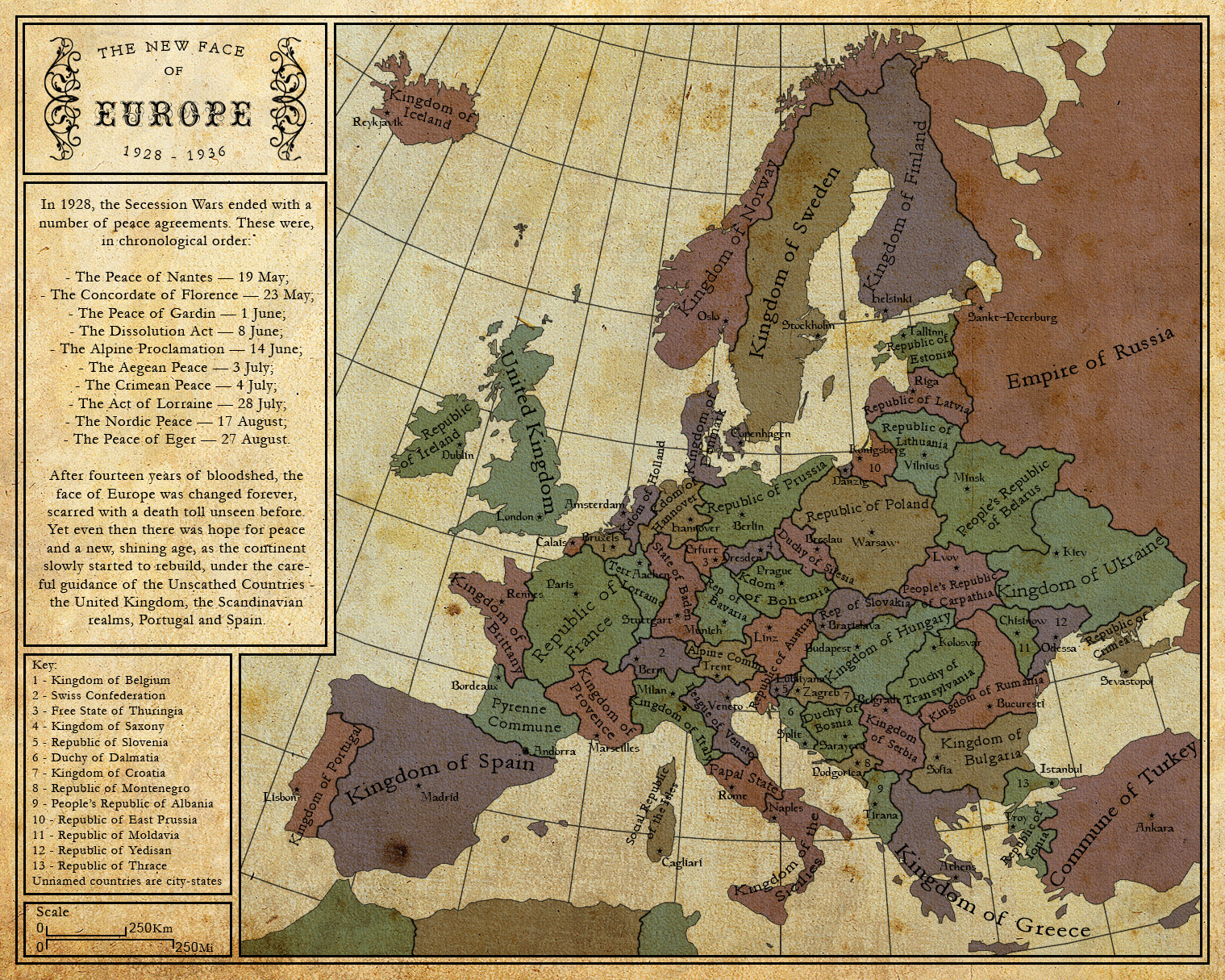
Map inspired by the recent discussion of a prolonged WW1 and by Highlander's map of a divided France. I'm not especially happy with how this turned out, but it's something, so here you go
(As usual, a click on the image will take you to my deviantart page)
Balkanised Europe! Lovely map.
there was an "all christians move to south carolina and we'll seceed" thing going on for a while. what if that happened, and before the US could mount a response, others began as well? not that well done, but sure was fun!what made such a north america?
- Status
- Not open for further replies.
Share: