Linguistic situation in the Eastern Great Lakes a) Before 800 BC b) from 500 BC to AD 100 c) from AD 100 to AD 500
![image0.jpg](https://cdn.discordapp.com/attachments/448261422926004244/1179592485899608064/image0.jpg?ex=65a87c9c&is=6596079c&hm=6a69314ab2a3d96d1416dea225bf83bc1809e462329acdaec8b0c8a1547112a4&)
Throwing Blades of Africa (Concentrated in Central Africa) from New book: 100 African Blades 100 Knieves from 55 collections March 02, 2021 by Ethan Rider
![RDT_20231130_0220271612505357517584863.jpg](https://cdn.discordapp.com/attachments/448261422926004244/1179592776455835658/RDT_20231130_0220271612505357517584863.jpg?ex=65a87ce1&is=659607e1&hm=034e5ddd76da6a29c128d2be49d3d1950ed5d7bbacee9063825f456d6786a96e&)
Throwing Blades of Central Africa
![F2Xn78nXkAI74yR.jpg](https://cdn.discordapp.com/attachments/858526713548767232/1180927024026624093/F2Xn78nXkAI74yR.jpg?ex=65a41cff&is=6591a7ff&hm=f833192ba6ef9219e18dd0fed39d5dd24e1316aa0ac663ac1c1b5fb1ed576547&)
parts of africa euros saw as ripe for colonizattion
Now, maps from this article. https://www.africanhistoryextra.com...dom-1550?utm_source=substack&utm_medium=email
![https%3A%2F%2Fsubstack-post-media.s3.amazonaws.com%2Fpublic%2Fimages%2Fa97489db-9f58-4e92-85ec-a46f7e919db1_481x644.jpeg](https://substackcdn.com/image/fetch/f_auto,q_auto:good,fl_progressive:steep/https%3A%2F%2Fsubstack-post-media.s3.amazonaws.com%2Fpublic%2Fimages%2Fa97489db-9f58-4e92-85ec-a46f7e919db1_481x644.jpeg)
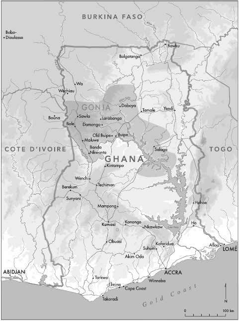
Map of Ghana showing the kingdom of Gonja at its height in the early 19th century
![https%3A%2F%2Fsubstack-post-media.s3.amazonaws.com%2Fpublic%2Fimages%2Fa319d249-0095-410f-96b3-4e3c3758efbf_725x581.png](https://substackcdn.com/image/fetch/f_auto,q_auto:good,fl_progressive:steep/https%3A%2F%2Fsubstack-post-media.s3.amazonaws.com%2Fpublic%2Fimages%2Fa319d249-0095-410f-96b3-4e3c3758efbf_725x581.png)
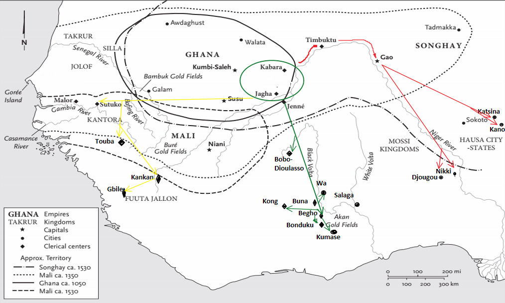
Purported migration of Gonja’s founders
![https%3A%2F%2Fbucketeer-e05bbc84-baa3-437e-9518-adb32be77984.s3.amazonaws.com%2Fpublic%2Fimages%2F47379540-b055-43b0-b21f-824168996710_1014x608.png](https://substackcdn.com/image/fetch/f_auto,q_auto:good,fl_progressive:steep/https%3A%2F%2Fbucketeer-e05bbc84-baa3-437e-9518-adb32be77984.s3.amazonaws.com%2Fpublic%2Fimages%2F47379540-b055-43b0-b21f-824168996710_1014x608.png)
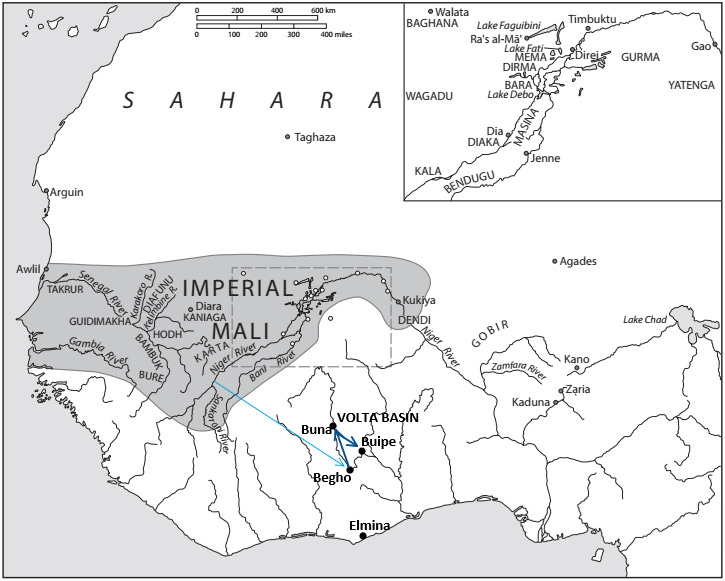
Sketch showing the southern expansion of the Juula (in green) to the cities of Begho and Buna.
![https%3A%2F%2Fsubstack-post-media.s3.amazonaws.com%2Fpublic%2Fimages%2Fbb1944c2-a345-4e9c-b82d-ad84be9d36f5_719x529.png](https://substackcdn.com/image/fetch/f_auto,q_auto:good,fl_progressive:steep/https%3A%2F%2Fsubstack-post-media.s3.amazonaws.com%2Fpublic%2Fimages%2Fbb1944c2-a345-4e9c-b82d-ad84be9d36f5_719x529.png)
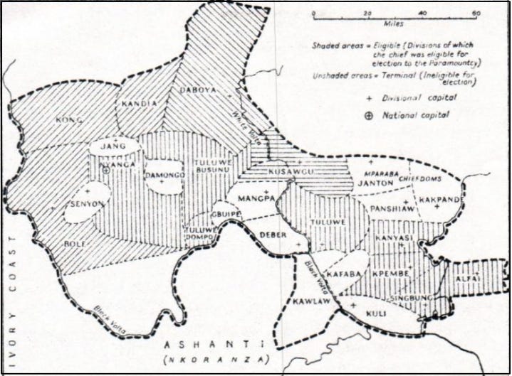
Map of the Gonja kingdom by Jack Goody, showing the main provinces/chiefdoms
![https%3A%2F%2Fsubstack-post-media.s3.amazonaws.com%2Fpublic%2Fimages%2F1ff43ab1-aa5a-4cd1-9e51-65e762cda211_854x490.png](https://substackcdn.com/image/fetch/f_auto,q_auto:good,fl_progressive:steep/https%3A%2F%2Fsubstack-post-media.s3.amazonaws.com%2Fpublic%2Fimages%2F1ff43ab1-aa5a-4cd1-9e51-65e762cda211_854x490.png)
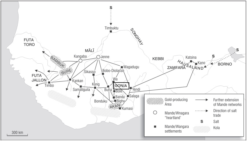
position of Gonja in the Mande trade network
And maps from this article https://www.persee.fr/doc/sfhom_1768-7144_1981_mel_5_1_949
Last edited: