African Resources Thread

Screenshot_20240105_034455_OneDrive.jpg

Linguistic situation in the Eastern Great Lakes a) Before 800 BC b) from 500 BC to AD 100 c) from AD 100 to AD 500

image0.jpg

Throwing Blades of Africa (Concentrated in Central Africa) from New book: 100 African Blades 100 Knieves from 55 collections March 02, 2021 by Ethan Rider

RDT_20231130_0220271612505357517584863.jpg

Throwing Blades of Central Africa


F2Xn78nXkAI74yR.jpg

parts of africa euros saw as ripe for colonizattion

Now, maps from this article. https://www.africanhistoryextra.com...dom-1550?utm_source=substack&utm_medium=email
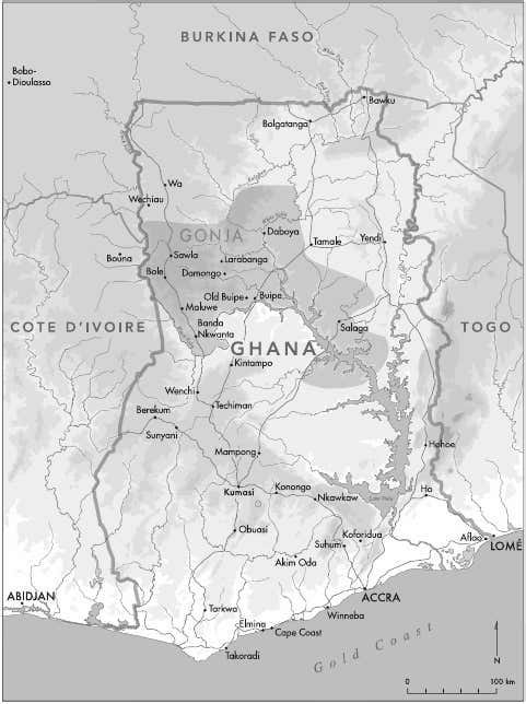
https%3A%2F%2Fsubstack-post-media.s3.amazonaws.com%2Fpublic%2Fimages%2Fa97489db-9f58-4e92-85ec-a46f7e919db1_481x644.jpeg

Map of Ghana showing the kingdom of Gonja at its height in the early 19th century
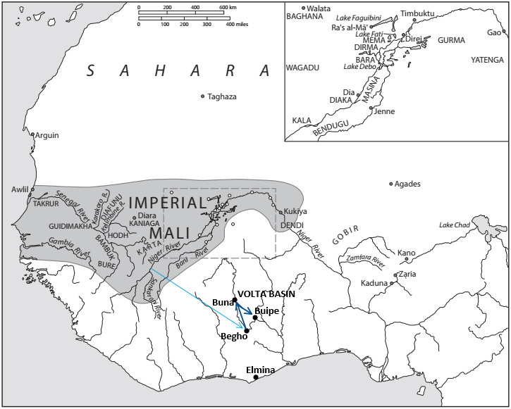

https%3A%2F%2Fsubstack-post-media.s3.amazonaws.com%2Fpublic%2Fimages%2Fa319d249-0095-410f-96b3-4e3c3758efbf_725x581.png

Purported migration of Gonja’s founders
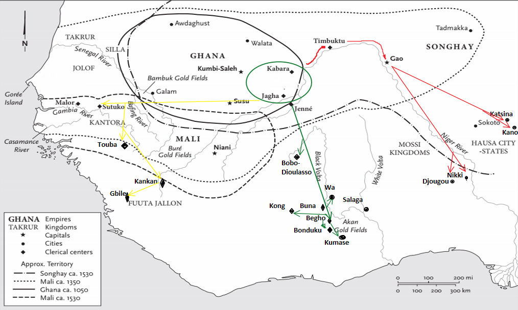
https%3A%2F%2Fbucketeer-e05bbc84-baa3-437e-9518-adb32be77984.s3.amazonaws.com%2Fpublic%2Fimages%2F47379540-b055-43b0-b21f-824168996710_1014x608.png

Sketch showing the southern expansion of the Juula (in green) to the cities of Begho and Buna.
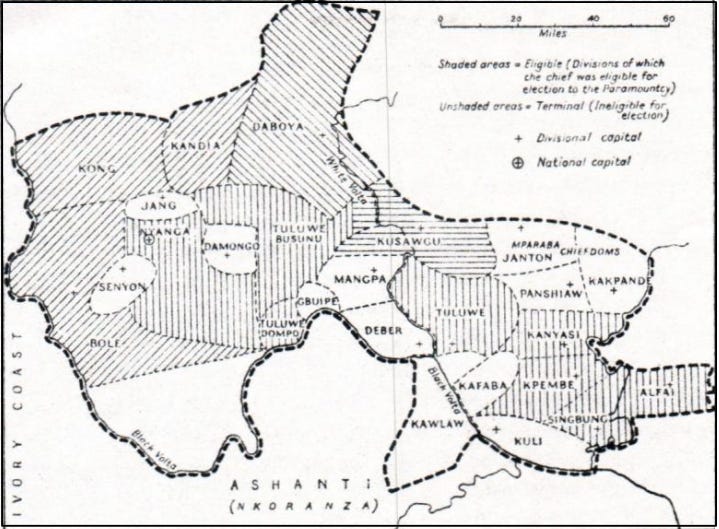
https%3A%2F%2Fsubstack-post-media.s3.amazonaws.com%2Fpublic%2Fimages%2Fbb1944c2-a345-4e9c-b82d-ad84be9d36f5_719x529.png

Map of the Gonja kingdom by Jack Goody, showing the main provinces/chiefdoms
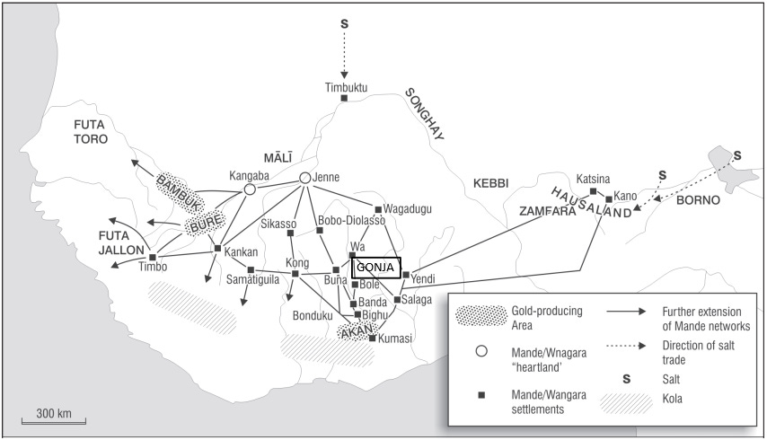
https%3A%2F%2Fsubstack-post-media.s3.amazonaws.com%2Fpublic%2Fimages%2F1ff43ab1-aa5a-4cd1-9e51-65e762cda211_854x490.png

position of Gonja in the Mande trade network

And maps from this article https://www.persee.fr/doc/sfhom_1768-7144_1981_mel_5_1_949


sfhom_1768-7144_1981_mel_5_1_949_1.png
Geography of the Western Sudan from al-Bakri

sfhom_1768-7144_1981_mel_5_1_949_Page_12_Image_0002.png


sfhom_1768-7144_1981_mel_5_1_949_Page_18_Image_0002.png


sfhom_1768-7144_1981_mel_5_1_949_Page_27_Image_0002.png


sfhom_1768-7144_1981_mel_5_1_949_Page_26_Image_0002.png
 
Last edited:
Major Styles of Collared and Cordoned Wares in the Senegal Valley from 600 CE and their Known ...PNG

Major Styles of Collared and Cordoned Wares in the Senegal Valley from 600 CE and their Known Distributions from https://www.academia.edu/77825973/S...50389691-ecf3-43f8-a63a-22b79499b389&rw_pos=0


Map of Archaeological Sites, Towns, and Regions Mentioned in the Text.PNG

Map of Archaeological Sites, Towns, and Regions Mentioned in the Text from https://www.academia.edu/77825973/S...50389691-ecf3-43f8-a63a-22b79499b389&rw_pos=0

The_Search_for_Takrur_Archaeological_Exc_Page_3.png

West African sites, trade routes, and gold producing areas circa ad 800 to 1500. Above, the Middle Senegal Valley and the project study area. from https://www.academia.edu/33627669/T...econnaissance_along_the_Middle_Senegal_Valley

The Middle Senegal Valley Project study area and excavated sites.PNG

The Middle Senegal Valley Project study area and excavated sites from https://www.academia.edu/33627669/T...econnaissance_along_the_Middle_Senegal_Valley

Map of early Saharan trade routes, areas, and sites.jpg

Map of early Saharan trade routes, areas, and sites from https://www.academia.edu/5846195/The_Ancient_Ghana_and_Mali_Project_Reconceptualizing_Early_Ghana

Approximate location of ecological zones, c.1600.jpg

Approximate location of ecological zones, c.1600 from https://www.academia.edu/5846195/The_Ancient_Ghana_and_Mali_Project_Reconceptualizing_Early_Ghana

Approximate location of ecological zones, c.1850.jpg

Approximate location of ecological zones, c.1850 from https://www.academia.edu/5846195/The_Ancient_Ghana_and_Mali_Project_Reconceptualizing_Early_Ghana


6116877ddbd2fc6807d70c798c7ae18c.jpg

Map of the kingdom of Benin, 16th century


img-7.jpg

img-8.jpg


2ccef170346498a6d131717dc76c4a6b.jpg

Les grandes tribus berbères de Libye selon Al-Ya’kûbî (fin du ixe siècle).

https://i.pinimg.com/originals/2c/ce/f1/2ccef170346498a6d131717dc76c4a6b.jpg
74ca36ab16b0d304f9eb368c0f7f888e.jpg

https://i.pinimg.com/originals/2c/ce/f1/2ccef170346498a6d131717dc76c4a6b.jpg
Trade in East Africa in 1870


Last edited:
unknown1.png


unknown_2.png

The former Beafada country, according to Oral traditions, European Sources and the Toponomy.

200905121658410828.png
Tse tse fly belt of Africa.

ca92cd62-9862-3dd9-b739-e12390efd71e.png
Population density map
 
Last edited:
image.png

image.png
Cyrenaica Tribes

sfhom_1768-7144_1981_mel_5_2_T1_0626_0000_1.png

The Kafus of the Mande, 19th century

IMG_9359.png

Togo-Be kingdom before European colonization

IMG_7878.png

Kingdom of Glindji, before European colonization

IMG_9358.jpg

Map of Porto Novo kingdom

IMG_9285.png

The Yoruba states during the Owu wars, 1820-1827

IMG_9468.png

Idoma Kingdoms

IMG_9499.png

Damagaram in the 19th century

south-eastern_congo.png

Map of Chiefdoms, "commercial zones" and salines, around The Congo's Katanga region, Northern Zambia & the South-Western Tanzania. from this book: https://www.kaowarsom.be/documents/..._Les sauniers de la savane orientale_2000.pdf

image.png

Volta-Bani War (From West African Challenge to Empire by Mahir Saul)

image.png
image.png

Twana settlements in the early 19th century: of the original 9 peoples, only the Skokomish survive as an independent people today

IMG_7473.jpg

Mandinka Kingdom of Tamba, in 1840

IMG_8707.png

Hausa Maradi and its surroundings (19th century)

IMG_8710.png

Kano Emirate and its vassals in the late 19th century

IMG_7973.jpg

Expansion of Ghana Empire

13938150_627283234105254_1091185359812103295_o.jpg

Map of the "Federation of Sukumaland"/"Sukumaland Federation". Best description of it that I've found as of yet (since I haven't checked any books about it, for the moment), would be from worldstatesmen: "1946 - 1960" Sukumaland Federation established by rulers of Siha (Busiha) and 50 small polities with a Federation Council chaired by ruler of Siha (Busiha)."

11IMG_1165.png

Similar map depicting "the ancient kingdoms of sukumaland"
 
Last edited:
IMG_7974.png

A Map showing Pre-Colonial (Pre-Partition) Gyaman (At the Peak of its Prowess)

IMG_8427.jpg

Administrative and Linguistic Borders between Tigray and Amhara/Gondor/Begemder/Dembea at different eras.

IMG_8432.png

Alternative definitions of Dafur

IMG_7740.png

Situation of the province of Soum and the Fulani kingdom of Djelgodji

IMG_7902.png

Kingdom of Anoufom

IMG_8570.png

The Equatorial Province

IMG_8656.png

A Description of Darfur

IMG_8704.png

Changing position of the boundary between Sudan and Ethiopia


IMG_7847.png


Seems some of the Links hv started breaking. I guess I should make as many of these as possible, downloaded unto this site as well.
If you used Discord as an image host, they've changed it so that the links to images update every so often, and it breaks any image posted outside the website (image links inside the discord app/website update automatically when the link changes)
 
If you used Discord as an image host, they've changed it so that the links to images update every so often, and it breaks any image posted outside the website (image links inside the discord app/website update automatically when the link changes)
Yeah, I used discord. That's too bad cuz not all these images would fit here otherwize and some are too detailed to try and drop their quality to fit it here. Later, I'll download and upload here directly the maps that can fit.
 
Yeah, I used discord. That's too bad cuz not all these images would fit here otherwize and some are too detailed to try and drop their quality to fit it here. Later, I'll download and upload here directly the maps that can fit.
You could screen shot and split the larger pictures by cropping them to fit here, might be a bit of work though since I'm basing the process of doing that off of how I would've done it on MS Paint 14years ago lol
 
@PecuTheGreat Assyrian tribes map from page 7 isn't there anymore.
Yeah, its like the apocalypse over there. Most of it is deadlinks now. Uh.

But anyways, I've changed my mind. I won't go and replace all the broken links. Way too much for the amount of time I now have. If someone requests a map I can still find elsewhere that's now broken, I'll drop it.

[/SPOILER]

mapofindependentassyriantribes_1.png

Independent_Assyrian_Tribes_and_Syriac_Christians_in_the_Early_19th_Century._The_Light_Pink_areas_are_Assyrian_Christians_subject_to_Kurds_and_Afshar.png
 
Last edited:
Top