African Resources Thread

6-Figure1-1.png

Figure 1: Map of Trade in Oyo, 1816

8-Figure2-1.png

Figure 2: Left to Right: 1825 conflict map via a kernel density estimate with h = 2; krig with ν = .5 and a = 5/2; krig with ν = 3 and a = 6

13-Figure3-1.png

Figure 3: Example of MDP decision chain for a start in S3 with an absorbing state in S1 under no conflict (yellow) or conflict (green)

13-Figure4-1.png

Figure 4: Example of MDP decision chains for 1825 (left) and 1826 (right)

15-Figure5-1.png

Figure 5: Simulated Slave Origins colored by their points-of-sale. Left to Right: increasing variance in rewards

16-Figure6-1.png

Figure 6: Estimated Versus Recorded Trans-Atlantic Slave Departures from the Bight of Benin

18-Figure7-1.png

Figure 7: Top: Model and Linguistic Data for a ship leaving Lagos, 1832; Bottom: for Ouidah

From


70e010bff194ddb3b63b2f045e7137ae7f232321.jpg

"Sokoto Caliphate and Neighboring States, c. 1850", Slavery Images: A Visual Record of the African Slave Trade and Slave Life in the Early African Diaspora, accessed July 10, 2023, http://104.200.20.178/s/yorubadiaspora/item/3335

Map_2_Sokoto_Caliphate_Borno_and_Bight_of_Benin_1840.jpg

Sokoto Caliphate, Borno and Bight of Benin, 1840

ddc934ce86afa3ff733eff52106972197764165b.jpg

"Oyo Empire and Neighboring States, c. 1780", Slavery Images: A Visual Record of the African Slave Trade and Slave Life in the Early African Diaspora, accessed July 10, 2023, http://104.200.20.178/s/yorubadiaspora/item/3333


6e610629cbcc708cf0644bdc2e1dc5586a582e4e.jpg
3-oyo-empire-at-its-greatest-extent-c-1780.jpg


Map_1_Bight_of_Benin_and_Central_Bilad_al-Sudan_1800.jpg

Bight of Benin and Central Bilād al-Sūdān, 1800

"Oyo Empire at Its Greatest Extent, c. 1780", Slavery Images: A Visual Record of the African Slave Trade and Slave Life in the Early African Diaspora, accessed July 10, 2023, http://104.200.20.178/s/yorubadiaspora/item/3337

Map_3_The_Ascension_of_Ilorin_and_Owu_Wars_1817-1822.jpg

The Ascension of Ilorin and Owu Wars, 1817–1822

Map_4_The_Egba_Crisis_1823-1830.jpg

The Egba Crisis, 1823–1830

Map_5_Oyos_Final_Years_1831-1836.jpg

Oyo’s Final Years, 1831–1836

From


I am doing these in part cuz I found out Lovejoy's Website is down so some of the maps linked from there might no longer work. Maybe they're backed up on the archive but I don't know.
 
Last edited:
https%3A%2F%2Fsubstack-post-media.s3.amazonaws.com%2Fpublic%2Fimages%2Fc29658bd-23e0-4d70-8361-c4e6382baef3_614x584.png

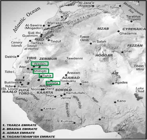
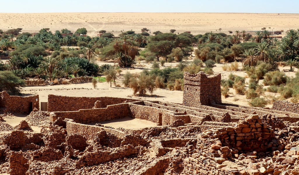
Map showing the old towns of the south-western Sahara

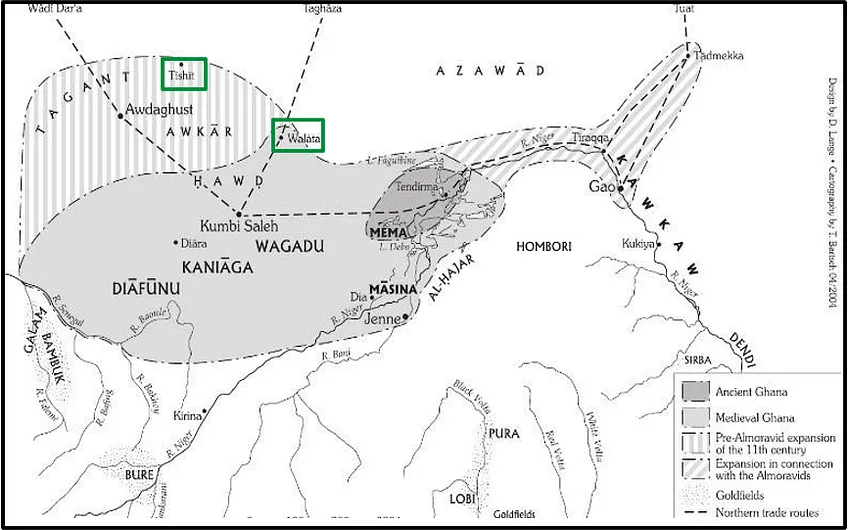
Walata emerges first as 'Biru', a major commercial hub linking the Saharan markets to the empires of Ghana into which it was later subsumed. Biru displaced the town of Awdaghust after the latter's collapse around the 11th/12th century to the empire of Ghana and the Almoravids. According to the Timbuktu chronicles, it was primarily settled by the Tafrast/Tafaranko people, a Azer/soninke-speaking group that migrated from the west (ie: Awdaghust).

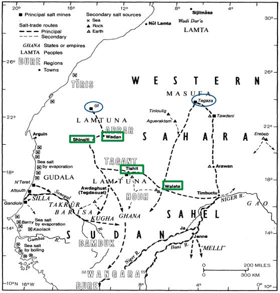
Conversly, Tichitt was settled in the 8th century by the Imansa/Masna, an autochthonous group of Soninke-speakers, who named the oasis after sound of spraying water (shitu). The town was an important node in the regional salt trade that would expand during the Ghana and Mali eras, and was linked to the salt trade of Ijil carried out by the Azer.

https%3A%2F%2Fsubstack-post-media.s3.amazonaws.com%2Fpublic%2Fimages%2F1818353d-b9f1-4b8e-8304-213d24fa211c_866x541.png

Walata and Tichitt in the empire of Ghana

https%3A%2F%2Fsubstack-post-media.s3.amazonaws.com%2Fpublic%2Fimages%2F05230f58-d700-4cdb-ae6b-862de01b93b5_559x585.png

The principle salt routes and salt sources ca. 1000-1700

https%3A%2F%2Fsubstack-post-media.s3.amazonaws.com%2Fpublic%2Fimages%2F5668d416-3421-46fc-a4ab-7f0a2088ecce_730x600.png

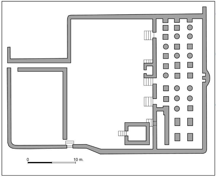
Chinguetti Mosque, Plan of the mosque

https%3A%2F%2Fsubstack-post-media.s3.amazonaws.com%2Fpublic%2Fimages%2Fc29658bd-23e0-4d70-8361-c4e6382baef3_614x584.png

Map showing the emirates of the south-western Sahara in the 18th-19th century.

All from

 
Last edited:
1-s2.0-S0277379122003262-gr1_lrg.jpg

Map of previously published Stone Age sites in Northern Botswana. Numbers refer to the site listing in SOM1. This does not include any grey literature/theses that are not available online. Numbered sites are listed in the map, unnumbered are too vague/cover too large an area to be precisely located on the map. Key to sites: 1. Rhino Cave, 2. Depression Shelter, 3. Divuyu, 4. Nqoma, 5. Unnamed shelters on Female Hill, 6. Tsodilo Shelter, 7. Tashrani, 8. Kudu Horn Shelter, 9. Ancestors' Cave, 10. White Paintings Shelter, 11. Greenstone Mine, 12. Corner Cave, 13. Savuti, 14. Northeast of Kachikau, 15. Mahopa, 16. ≠Gi, 17. !ubi, 18./dwichu, 19. Xaixai, 20. Gcwihaba Caves 21. !Ncumtsa Hills, 22. Toteng, 23. SW of Toteng, 24. Mogapelwa, 25. Old edge of Lake Ngami, 26. Kgwebe Hills, 27. Ngwanalekau Hills area, 28. Mabeleapudi ridge, 29. Kuke Pan, 30. Gemsbok Pan, 31. Ghanzi, 32. Buitsivango, 33. Mamuno, 34. Okwa River/Tswaane borehole, 35. Matlapaneng, 36. Lotshitshi, 37. Maun, 38. Samedupe Drift, 39. Makalamabedi Drift, 40. Bushman Pits, 41. Kudiakam Pan, 42. Ngxaishini Pan, 43. Northeast of Gweta, 44. Gweta, 45. Makgadikgadi Pans general area (all Stone Age sites from the New Mexico Kalahari Project are listed under this number), 46. Gutshaa Pan, 47. Rakops area, 48. Toromoja, 49. Toromoja I, 50. Gwi Pan West, 51. Xhorodomo Pan, 52. Kedia Hill, 53. Orapa Diamond Mine, 54. Lothlekane Well, 55. Inkowane Pan, 56. South Sua Pan, 57. Tshwane, 58. Nata River delta, 59. Nata, 60. Nata River, 61. Mantenge Shelter, 62. Domboshamba Ruin.

1-s2.0-S0277379122003262-gr2_lrg.jpg

Map of newly-discovered Stone Age sites and scatters in northern Botswana. The Collaborative Program for San/Basarwa Research and Capacity Building (1999–2006) (purple), the Kalahari Silcrete Provenancing Project (2011) (yellow) and the Landscape Archaeology of the Kalahari Project (2016–2018) (green). The numbers refer to the site listing in SOM2. Numbers between 126-228 not listed on the map are located in dense swathe, shown in green, in north Ntwetwe Pan. Key to sites: 1-2. Southwest of Lake Ngami, 3. Small pan, southwest of Lake Ngami, 4. Magoagoa cattle post, 5. Flats north of Kareng, 6. Banks of Boteti River, 8. Kings Pool Camp, 9. Airstrip, south of Kings Pool Camp, 10. Access road to Duma Tau Lodge, 11. Makalamegi, along Boteti River, 12. Seokwane 3, 13. Seokwane, 14. Seokwane 12, 15. Rakops (East), 16. Rakops (North), 17. West side of new road – north of Kuke Gate, 18–19. Motabologa Hill, south of Sethitwa, 20. South of Motabologa Hill, 21. Along A3, south of Lake Ngami, 22–24. On A3, 30 km south of Sethitwa, 25. Shakawe, 26–27. West bank of Okavango Panhandle, 28. Quarry, near Shakawe airstrip, 29–30. LSA scatters, Female Hill, 31. On road to Nokaneng and east of Xangwa, 32. North of Tsau, 33. On old Thaoge watercourse, 34–36. North of Tsau, 37. South of Damara, 38. Old quarry near Makakung, 39. South of Makakung, 40. East of Kareng, 41. Eastern edge of Dautsa Flats, 42–44. Okwa Valley, 45. D'qae Qare San Lodge, 46. Quarry Hill, 47. Hills near Savuti Channel, 48. Saddle between Kudu Hills, 49–53. Near Bushman Hill Paintings, Savuti, 54. Washout, near Kareng, 55–57. Near Kareng, 58–59. Test excavation, ‘Canoe’ grooved stone, Female Hill, 60. Near Makakung, 61–62. North of Kareng, 63. South of Kareng, 64. Dautsa, 65. East of Dautsa, 66. Test site, Dautsa, 67–69. Semowane River course, 70. Near excavated site, south of Dzibui (Gwi) Pan, 71. Escarpment road south of Sua Pan, 72. Near Bothatogo, 73. Plateau south of Lake Ngami, 74. South bank of Lake Ngami, 75–77. West of Lake Ngami, near Bodibeng, 78. KNG5, near Kareng, 79. LSA finds, Molatu rock art site, 80–81. East of Bothatogo, 82. Shakawe quarry, 83–85. Xaudum valley, 86. Nxaunxau, 87. Xangwa village, 88. Dobe, 89. Dobe Pan, 90. South margin of Lake Ngami, 91–93. South margin of western end Lake Ngami, 94. Tale Pan, 95. Samedupe Drift, 96. West of Samedupe Drift Bridge, 97. Makalamabedi, 98. Motopi, 99. BOTE01, 100. BOTE02, 101. BOTE03, 102. BOTE04, 103. BOTE05, 104. BOTE06, 105. BOTEFS01, 106. BOTEFS02, 107. BOTEFS03, 108. BOTEFS04, 109. BOTEFS05, 110. BOTEFS06, 111. BOTEFS07, 112. BOTEFS08, 113. BOTEFS09, 114. BOTEFS10, 115. BOTEFS11, 116. BOTEFS12, 117. BOTEFS13, 118. BOTEFS14, 119. DZI01, 120. DZI02, 121. DZIFS01, 122. DZIFS02, 123. DZIFS03, 124. DZIFS04, 125. DZIFS05, 126. MAK01, 127. MAK02, 128. MAK03, 129. MAK04, 130. MAK05, 131. MAK06, 132. MAK07, 133. MAK08, 134. MAK09, 135. MAK10, 136. MAK11, 137. MAK12, 138. MAK13, 139. MAK14A, 140. MAK14B, 141. MAK14C, 142. MAK14D, 143. MAK14E, 144. MAK14F, 145. MAK14G, 146. MAK14I, 147. MAK14J, 148. MAK14K, 149. MAK14L, 150. MAK14M, 151. MAK14N, 152. MAK14O, 153. MAK15, 154. MAK16, 155. MAK17, 156. MAK18, 157. MAK19, 158. MAK20, 159. MAK21, 160. MAK22, 161. MAK23, 162. MAK24, 163. MAK25, 164. MAK26, 165. MAK27, 166. MAK28, 167. MAK29, 168. MAK30, 169. MAK31, 170. MAK32, 171. MAK33, 172. MAK34, 173. MAK35, 174. MAK36, 175. MAK37, 176. MAK38, 177. MAKFS01, 178. MAKFS02, 179. MAKFS03, 180. MAKFS04, 181. MAKFS05, 182. MAKFS06, 183. MAKFS07, 184. MAKFS08, 185. MAKFS09, 186. MAKFS10 (Sweetwater Pan), 187. MAKFS11 (Christian Pan), 188. MAKFS12, 189. MAKFS13, 190. MAKFS14, 191. MAKFS15, 192. MAKFS16, 193. MAKFS17 (Gweta Quarry), 194. MAKFS18, 195. MAKFS19, 196. MAKFS20, 197. MAKFS21, 198. MAKFS22, 199. MAKFS23, 200. MAKFS24, 201. MAKFS25, 202. MAKFS26, 203. MAKFS27, 204. MAKFS28, 205. MAKFS29, 206. MAKFS30, 207. MAKFS31, 208. MAKFS32, 209. MAKFS33, 210. MAKFS34, 211. MAKFS35, 212. MAKFS36, 213. MAKFS37, 214. MAKFS38, 215. MAKFS39, 216. MAKFS40, 217. MAKFS41, 218. MAKFS42, 219. MAKFS43, 220. MAKFS44, 221. MAKFS45, 222. MAKFS46, 223. MAKFS47, 224. MAKFS48, 225. MAKFS49, 226. MAKFS50, 227. MAKFS51, 228. MAKFS52, 229. NAT01, 230. NATFS01, 231. NATFS02, 232. NATFS03, 233. XORFS01, 234. XORFS02, 235. XORFS03, 236. XORFS04, 237. XORFS05, 238. XORFS06, 239. XORFS07. (For interpretation of the references to colour in this figure legend, the reader is referred to the Web version of this article.)

1-s2.0-S0277379122003262-gr6_lrg.jpg

Overview of newly-discovered a) ESA, b) MSA and c) LSA and pastoralist sites from recent surveys in northern Botswana. The Collaborative Program for San/Basarwa Research and Capacity Building (1999–2006) (purple), the Kalahari Silcrete Provenancing Project (2011) (yellow) and the Landscape Archaeology of the Kalahari Project (2016–2018) (green). Details of sites in SOM2. (For interpretation of the references to colour in this figure legend, the reader is referred to the Web version of this article.)

From


acrefore-9780190277734-e-71;jsessionid=73B43059D042D3247EF7ACFC3E5D772E

Map of Botswana showing the locations of archaeological sites and geographic features mentioned in the text

From


Map-of-southern-Africa-with-archaeological-sites-mentioned-in-the-text-base-map-by-Matt.jpg

from


acrefore-9780190277734-e-792-graphic-001-full.jpg

Archeology in Botswana

acrefore-9780190854584-e-255-graphic-001-full.gif

Early Iron Age in Botswana

 
Last edited:
1-s2.0-S2666033421000010-gr1.jpg

Position of Tsodilo Hills (black triangle) in the modern southern African climate setting. Left: Major atmospheric (white arrows) and oceanic (blue arrows) circulation systems are shown as well as austral summer positions of ITCZ and Congo Air Boundary (CAB). Predominant (≥50%) austral winter rainfall is confined to violet to green coloured areas (permission for the use of artwork granted from Chevalier and Chase, 2016). Right: Zonation of mean annual precipitation (after Conway et al., 2015). Circles outline areas from where earliest modern humans may have originated (1 = Tishkoff et al., 2009; 2 = Chan et al., 2019).

1-s2.0-S2666033421000010-gr2.jpg

DEM of the Kalahari drainage system with position of Tsodilo Hills (after Riedel et al., 2014). Mean annual precipitation and temperature for indicated settlements are compiled in Table A.1; b) Extension of the drainage basin west of Tsodilo Hills, which is in the focus of this study (after Wiese et al., 2020).

1-s2.0-S2666033421000010-gr3.jpg

TanDEM-X DEM of the study area showing the palaeolake depressions west of the Tsodilo Hills and sampling locations of previous studies with corresponding assumed palaeolake extensions (Brook, 1992; Robbins et al., 1994, 2000; Thomas et al., 2003; Wiese et al., 2020).

1-s2.0-S2666033421000010-gr4.jpg

View from Male Hill to the northwest, across the palaeolake beds. Vegetation types are exemplified.

1-s2.0-S2666033421000010-gr5.jpg

Climate chart (AD 1981–2010) for Tsodilo. Precipitation and temperature values derived from the ERA5 reanalysis dataset (Copernicus Climate Change Service, 2019). Evapotranspiration values calculated with ETo calculator (FAO, 2012).

1-s2.0-S2666033421000010-gr6.jpg

TanDEM-X DEM showing DPGS and geophysical transects and sediment pits.

1-s2.0-S2666033421000010-gr7.jpg

TanDEM-X DEM exhibiting major palaeo-shorelines and -rivers. B. Magnification of the area with a supposed tectonic fault.

1-s2.0-S2666033421000010-gr8.jpg

Landsat image with the course of the former Palaeolake Tsodilo outflow sketched. The outflow created the Tamacha River, which formed a pronounced delta in the Okavango Panhandle. The red triangle indicates the position of the Female Hill and the dashed line passing it follows the highest palaeo-shoreline we could infer.

1-s2.0-S2666033421000010-gr10.jpg

DGPS-elevation-profiles T0 to T5 (Fig. 6) with corrected and uncorrected values in comparison with TanDEM-X data

1-s2.0-S2666033421000010-gr11a.jpg
1-s2.0-S2666033421000010-gr11b.jpg

Lithologies and radiocarbon ages of pits N-18, S2-18 and S1-18. B. Lithology and selected geochemical and mineralogical properties for Pit S-15. Radiocarbon ages from Wiese et al. (2020) are marked with red asterisks.

[IMGhttps://ars.els-cdn.com/content/image/1-s2.0-S2666033421000010-gr12.jpg[/IMG]

Interpretation of selected geochemical and mineralogical properties of Pit S-15-sediments. Cross-striped bars indicate values not considered for interpretation due to allogenic deposition. Corresponding graphs for other pits are provided in the supplements

1-s2.0-S2666033421000010-gr13.jpg

Inverted sections (light blue) of palaeo-river beds with focus on a Y-shaped structure. B. TanDEM-X image of Y-shaped positive form. Red line refers to the position of C. River bed inversion by accumulation.

1-s2.0-S2666033421000010-gr14.jpg

Simulation of reconstructed fluvio-lacustrine systems. Hatched areas indicate alluvial fan deltas. DGPS transect T0 indicated; different colours referring to Fig. 14E. A. Hydrological setting during ≥100 ka. B. Hydrological setting during LGM. C. Hydrological setting during MIS 3b. D. Hydrological setting during an undetermined period. E. DGPS transect T0 in relation to settings A-D.

from

 
Location-of-southern-Africa-showing-madzimbahwe-mizinda-or-capitals-associated-with.gif


Location of southern Africa showing madzimbahwe/mizinda or capitals associated with sociopolitical complexity​


from https://www.researchgate.net/figure...da-or-capitals-associated-with_fig1_297654019

Map-showing-the-distribution-of-dzimbahwe-Zimbabwe-tradition-stone-walled-sites-and.gif


Map showing the distribution of dzimbahwe/Zimbabwe tradition stone-walled sites and Portuguese feiras/trading stations in southern Zambezia (Garlake 1970; Pikirayi 1993; Newitt 1995)​


Map-of-southern-Zambezia-showing-some-of-the-sites-discussed-in-the-text.gif


Map of southern Zambezia showing some of the sites discussed in the text​


from https://www.researchgate.net/figure...he-sites-discussed-in-the-text_fig1_310602774

Dryland-landscapes-of-southern-Zambezia-and-some-sites-mentioned-in-the-text-1-Ingombe.jpg


Dryland landscapes of southern Zambezia and some sites mentioned in the text: 1 Ingombe Illede; 2 Kadzi; 3 Kasekete; 4 Ndongo; 5 Charumani 2; 6 Chibuene; 7 Manyikeni; 8 Mwenezi; 9 Mulumba; 10 Tshobwane; 11 Mutshilachokwe; 12 Mtao Village 16; 13 Thulamela; 14 Weipe; 15 Schroda; 16 K2; 17 Mapungubwe; 18 Samaria; 19 Faure; 20 Leokwe; 21 Rhodes Drift; 22 JC Hill; 23 Megwe; 24 Domboshaba; 25 Selolwe; 26. Vumba; 27. Toutswemogala; 28 Taukome; 29 Mapela and Little Mapela; 30 Jahunda; 31 Khami; 32 Danamombe; 33 Tabazikamambo; 34 Great Zimbabwe.​


from https://www.researchgate.net/figure...entioned-in-the-text-1-Ingombe_fig1_329755019
 
Simplified geological map of Madagascar after Bésairie [1971],.png

Figure 1. Simplified geological map of Madagascar after Bésairie [1971],
Jourde [1971], and Collins [2000]. 1, Sediments; 2, volcanic formations; 3,
Bemarivo orogenic belt; 4, Antongil Block; 5, Antananarivo Block; 6, Itremo
sheet; 7, Ikalamavony Domain; 8, Anosyen Domain; 9, Androyen Domain;
and 10, Vohibory Domain. Grey lines are shear zones modified after
Martelat et al. [2000] Ej, Ejeda; Am, Ampanihy; Be, Beraketa; Ra, Ranotsara;
Za, Zazafotsy; and If, Ifanadiana. Dashed black line is the proposed plate
boundary between the Lwandle plate and Somalian plate [Stamps et al.,
2014]. Red frame marks the research area shown in Figures 5 and 6. Green
triangles show broadband stations, green diamonds denote short-period
stations, and the red square marks the permanent station VOI of the
GEOFON network.
 
Okay, boys. All the Maps from General history of Africa, V Africa from the sixteenth to the eighteenth century

The Whole continent

Africa the main points of European trade contact during the sixteenth to eighteenth centuries.png
Africa the main points of European trade contact during the sixteenth to eighteenth centuries

African trade routes in the sixteenth century Source; adapted from map drawn by P. Ndiaye, Dep...png
African trade routes in the sixteenth century Source; adapted from map drawn by P. Ndiaye, Department of Geography, University of Dakar

Africa, Europe and Asia Source; adapted from map drawn by Dr Dulal C. Goswami, Geology and Geo...png
Africa, Europe and Asia Source; adapted from map drawn by Dr Dulal C. Goswami, Geology and Geography Department, Howard University, Washington DC

North of the Oubanguides

Western Sudan

Senegambia in the sixteenth to eighteenth centuries.png
Senegambia in the sixteenth to eighteenth centuries

Trans-Saharan routes in the sixteenth to eighteenth centuries.png
Trans-Saharan routes in the sixteenth to eighteenth centuries

The Timbuktu Region.png
The Timbuktu Region

The Niger-Volta region in the sixteenth to eighteenth centuries.png
The Niger-Volta region in the sixteenth to eighteenth centuries

West Africa

Major population groups of West Africa_.jpg
Major population groups of West Africa

Migratory movements of the peoples of West Africa, fifteenth to eighteenth centuries-.png
Migratory movements of the peoples of West Africa, fifteenth to eighteenth centuries

The main states of West Africa, pre-sixteenth century-.jpg
The main states of West Africa, pre-sixteenth century-
 
Last edited:
North of the Oubanguides

Morocco


Morocco in the sixteenth and seventeenth centuries (after M. El Fast).png
Morocco in the sixteenth and seventeenth centuries (after M. El Fast)

The stages of Don Sebastian's progress towards the site of the 'Battle of the Three Kings' at ...png
The stages of Don Sebastian's progress towards the site of the 'Battle of the Three Kings' at Wadi al-Makhâzin, 30 July to 4 August ¡578 (after M. El Fast)

The empire of Ahmad al-Mansur, 'the Golden (1578-1603) (after M. El Fast).png
The empire of Ahmad al-Mansur, 'the Golden (1578-1603) (after M. El Fast)

The principalities of northern Morocco in the early seventeenth century (after M. El Fast).png
The principalities of northern Morocco in the early seventeenth century (after M. El Fast)

The Hausalands

Hausa states in the eighteenth century Source; adapted from P, Lovejoy, Caravans of Kola The H...png
Hausa states in the eighteenth century Source; adapted from P, Lovejoy, Caravans of Kola The Hausa Kola Trade, 1700 - 1900

Hausaland, pre-1800.png
Hausaland, pre-1800

Bornu

Borno, Känem and their immediate neighbours in the eighteenth century -.jpg
Borno, Känem and their immediate neighbours in the eighteenth century

Plan of Kukawa, the nineteenth-century capital of Borno, built in a double form of the traditi...png
Plan of Kukawa, the nineteenth-century capital of Borno, built in a double form of the traditional Kanuri design Source; adapted from H. Barth, 1857, II, pp. 50-1

Trans-Saharan Trade Route

Diagram showing the main trade and caravan links in the Sahara and west and central Sudan, c.1...png
Diagram showing the main trade and caravan links in the Sahara and west and central Sudan, c.1215 Source; adapted from M . Hiskett, The Development of Islam in West Africa

The Central Sudan and North Africa in 1600 -.png
The Central Sudan and North Africa in 1600
 
Last edited:
East African Orogenic Zone

Egypt


Lower Egypt (al-Delta) Source; adapted from 'Abd al-Rahim al-Rahman and Wataru Miki, Village i...png
Lower Egypt (al-Delta) Source; adapted from 'Abd al-Rahim al-Rahman and Wataru Miki, Village in Ottoman Egypt and Tokugawa Japan - A Comparative Study, Institute for the Study of Languages and Cultures of Asia and Africa, Tokyo

Middle and Upper Egypt (al-Said).png
Middle and Upper Egypt (al-Said)

Sudan

Trade routes of the Sudan (after Y. F. Hasan).png
Trade routes of the Sudan (after Y. F. Hasan)

Kingdoms and sultanates of the Sudan (after Y. F. Hasan).png
Kingdoms and sultanates of the Sudan (after Y. F. Hasan)

Peoples of the Sudan (after Y. F. Hasan).png
Peoples of the Sudan (after Y. F. Hasan)


Mozambique and Malawi

Pre-dynastic groups in Northern Zimbabwe (after K. M. Phiri and O. J. M. Kalinga).png
Pre-dynastic groups in Northern Zimbabwe (after K. M. Phiri and O. J. M. Kalinga)

The Maravi expansion, c.1650 (after K. M. Phiri).jpg
The Maravi expansion, c.1650 (after K. M. Phiri)

Ivory trade routes in East-Central Africa in the eighteenth century (after E. A. Alpers, UCLA).png
Ivory trade routes in East-Central Africa in the eighteenth century (after E. A. Alpers, UCLA)

Peoples of the Northern Zambezi region in the eighteenth century.png
Peoples of the Northern Zambezi region in the eighteenth century

The prazos of the lower Zambezi valley -.jpg
The prazos of the lower Zambezi valley
 
Last edited:
East African Orogenic Zone, continue

East African Hinterland


Ethnic groups of Kenya and Tanzania Source; adapted from map drawn by M. Kivuva.png
Ethnic groups of Kenya and Tanzania Source; adapted from map drawn by M. Kivuva

The Nyarubanga and the fragmentation of the Luo , c. 1570 - 1720.jpg
The Nyarubanga and the fragmentation of the Luo , c. 1570 - 1720

The Lacustrine

The southern Great Lakes region at the end of the seventeenth century (after J. P. Chrétien).png
The southern Great Lakes region at the end of the seventeenth century (after J. P. Chrétien)


Ethiopia

The Ethiopian empire and its dependencies, c. 1550 (after E. Haberland).png
The Ethiopian empire and its dependencies, c. 1550 (after E. Haberland)

South-eastern Ethiopia, c. 1500 (after E. Haberland).png
South-eastern Ethiopia, c. 1500 (after E. Haberland)

Oromo migrations in the sixteenth century (after E. Haberland).png
Oromo migrations in the sixteenth century (after E. Haberland)

Christianity in north-eastern Africa, c. 1700 (after E. Haberland).png
Christianity in north-eastern Africa, c. 1700 (after E. Haberland)

Madagascar

Ethnic groups of Madagascar Source; adapted from map of Madagascar from Early Kingdoms m Madag...png
Ethnic groups of Madagascar Source; adapted from map of Madagascar from Early Kingdoms m Madagascar, 1500 - 1700 by Raymond K. Kent

Indian Ocean Coast

The western Indian Ocean basin (after A. I. Salim).png
The western Indian Ocean basin (after A. I. Salim)

The East African coast (after A. I. Salim).png
The East African coast (after A. I. Salim)
 
Last edited:
Bantu Africa

Southern Africa


Central and south-eastern Africa during the period ofthe Mutapa and Torwa states Source; adapt...jpg
Central and south-eastern Africa during the period of the Mutapa and Torwa states Source; adapted from S. I. Mudenge, A Political History of Munhumutapa c. 1400 - 1902

The Rozvi empire Source; adapted from D. N. Beach, Zimbabwe before 1900,.png
The Rozvi empire Source; adapted from D. N. Beach, Zimbabwe before 1900,

The main feiras in the sixteenth and seventeenth centuries Source; adapted from map 3 of H. H....jpg
The main feiras in the sixteenth and seventeenth centuries Source; adapted from map 3 of H. H. K. Bhila, Trade and Politics m a Shona Kingdom. The Manyika and their African and Portuguese Neighbours, 1575-1902

Southern Africa in the sixteenth to eighteenth centuries.png
Southern Africa in the sixteenth to eighteenth centuries


West Central Africa's Lower Guinea

Kongo and its neighbours in the sixteenth century (after J. Vansina).png
Kongo and its neighbours in the sixteenth century (after J. Vansina)

Topography and natural resources of Kongo (after J. Vansina).jpg
Topography and natural resources of Kongo (after J. Vansina)

Kingdoms and trade of the Kongo region in the seventeenth century, with inset map of Ndongo (a...png
Kingdoms and trade of the Kongo region in the seventeenth century, with inset map of Ndongo (after J. Vansina)

Shipping routes to Central Africa, seventeenth and eighteenth centuries (after J. Vansina).png
Shipping routes to Central Africa, seventeenth and eighteenth centuries (after J. Vansina)

The slave trade in Central Africa in the eighteenth century (after J. Vansina).png
The slave trade in Central Africa in the eighteenth century (after J. Vansina)

West Central Africa in the eighteenth century (after J. Vansina).png
West Central Africa in the eighteenth century (after J. Vansina)


Last edited:
West Central Africa's Lower Guinea, Continues, Inland.
The states in Shaba before 1700 (after J. Vansina).png
The states in Shaba before 1700 (after J. Vansina)

The Luba kingdom in the eighteenth and nineteenth centuries (after J. Vansina).png
The Luba kingdom in the eighteenth and nineteenth centuries (after J. Vansina)

Population migrations in the Uele-Ubangi regions -.jpg
Population migrations in the Uele-Ubangi regions -

Peoples and spheres of influence along the Congo-Zaire axis.png
Peoples and spheres of influence along the Congo-Zaire axis

More Trans-Saharan

Borno's links with North Africa and the Nile valley in the eighteenth century.png
Borno's links with North Africa and the Nile valley in the eighteenth century

End of Maps from General history of Africa, V Africa from the sixteenth to the eighteenth century
 
Last edited:
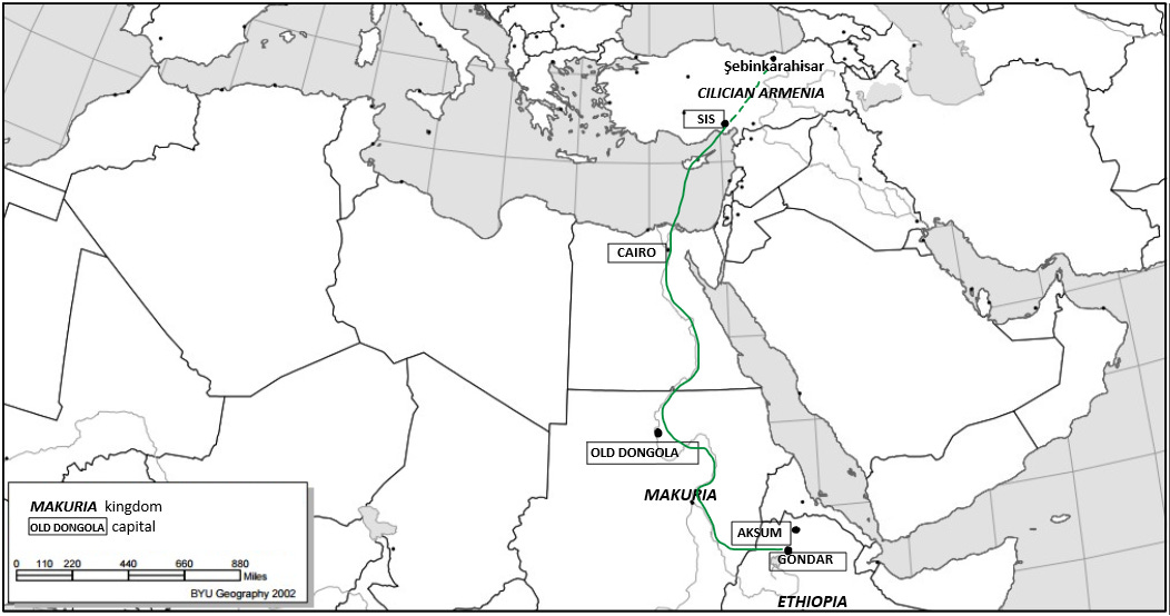
https%3A%2F%2Fsubstack-post-media.s3.amazonaws.com%2Fpublic%2Fimages%2F0468f163-d56c-45e9-89a2-b2685c2b5555_1052x554.png
Map showing the kingdoms of Armenia, Makuria and Ethiopia as well as the probable route taken by Ewostatewos from Ethiopia to Armenia.

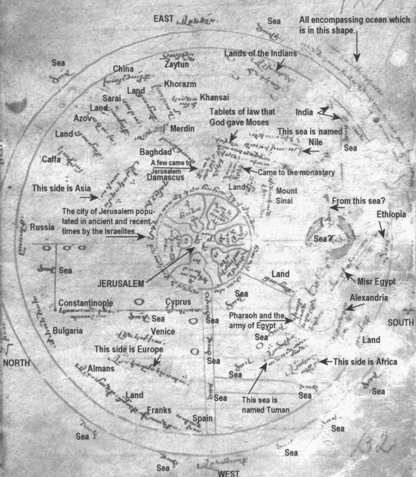
https%3A%2F%2Fsubstack-post-media.s3.amazonaws.com%2Fpublic%2Fimages%2F2f3a0e24-7242-42c4-9ab4-ca93da5ff9f6_823x945.png
Medieval Armenian T-O map, 13th-15th century, Yerevan, Matenadaran, MS 1242. Ethiopia is shown on the extreme east as ‘hapash’

From

 
North of the Oubanguides

West Africa (Guinea)


The main states of West Africa, pre-sixteenth century-.jpg
The main states of West Africa in the seventeenth century

Guinea
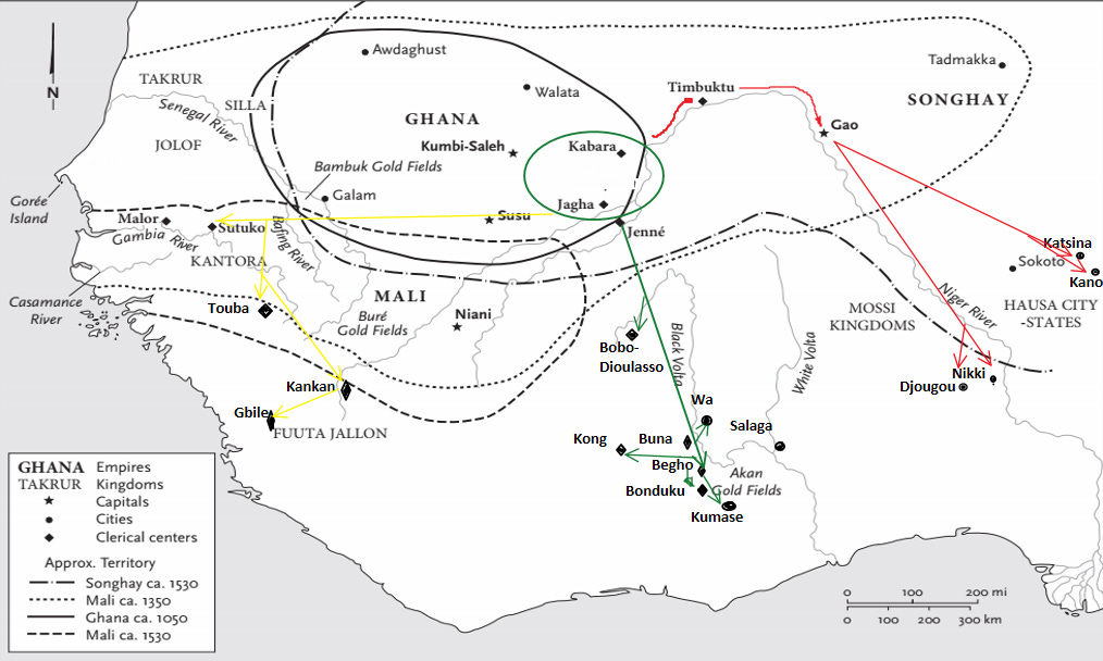
The Akan, Ga and Ewe peoples.png
The Akan, Ga and Ewe peoples

Principal trade routes of the Bandama-Volta-Mono basins.png
Principal trade routes of the Bandama-Volta-Mono basins

Trade routes between Hausaland and the Volta basin.png
Trade routes between Hausaland and the Volta basin

Re-drawing of a 1629 map of the Gold Coast.png
Re-drawing of a 1629 map of the Gold Coast

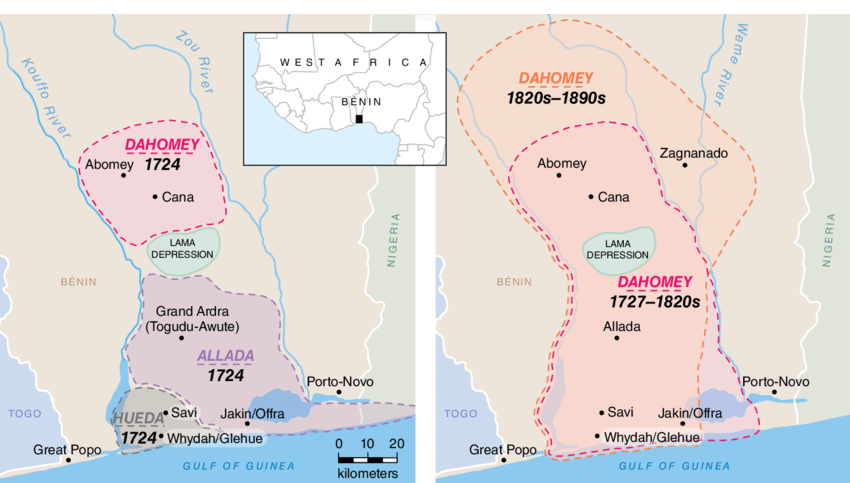
States of the Lower Guinea coast, 1700-.png
States of the Lower Guinea coast, 1700

States of the Lower Guinea coast, 1750.png
States of the Lower Guinea coast, 1750

The Niger Delta area and Cameroon in the sixteenth to eighteenth centuries -.png
The Niger Delta area and Cameroon in the sixteenth to eighteenth centuries


Magreb

Algeria, Tunisia and Libya in the sixteenth to eighteenth centuries.png
Algeria, Tunisia and Libya in the sixteenth to eighteenth centuries


Okay, actual end of Maps from General history of Africa, V Africa from the sixteenth to the eighteenth century.
 
Last edited:
Top