A map of the world 66 million years ago, at the time of the K-Pg extinction event. Mostly based on a deeptimemaps.com map.
You are using an out of date browser. It may not display this or other websites correctly.
You should upgrade or use an alternative browser.
You should upgrade or use an alternative browser.
A Blank Map Thread
- Thread starter Matt
- Start date
qazse
Gone Fishin'
Could your other paleogeographic map series potentially come out of hiatus?View attachment 777260
A map of the world 66 million years ago, at the time of the K-Pg extinction event. Mostly based on a deeptimemaps.com map.
I want to generate an over 5,000 pixels wide Equi-rectangular map of 27-30 metres below level, what Tutorials, data and apps do I need?.
Idk if someone has posted this before
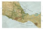
After way too much searching for an Image of lake texcoco that gives you any idea of the scale of the thing and roughly where it was situated I have found a nice map by national geographic and I am posting it here so no oneelse needs to do this again. No more google maps eyeballing for me.
And yes I am making a map that requieres a lake texcoco reconstruction. Idk if its requiered but I am not profiting from this in any way. All rights to respective holders.
Attachments
What I like to call a U.S.-BAM. Without any further sources, I'm attributing this to @Reagent, since this is a modified version of a map in their UACOG timeline.
Here's one for presidential elections, featuring the split votes in Nebraska and Maine.
View attachment 808736
Previously, I had to project Maine onto an existing map here that was missing portions of its coastline, but here's a complete versiom.
I also now have a proper source for it: Dave Leip's Election Atlas.
So about ~60 m rise? Although if I'm correct that'd be for a Greenland-only melt.Anyone know where I can find a BAM with countries and maximum sea level rise (Antarctica entirely thawed out)?
I think the icecaps both melting is 60 m? Just Greenland would be rather less than that.So about ~60 m rise? Although if I'm correct that'd be for a Greenland-only melt.
"If all glaciers and ice sheets melted, global sea level would rise by more than 195 feet (60 meters)."I think the icecaps both melting is 60 m? Just Greenland would be rather less than that.
Greenland alone would be 7,4mI think the icecaps both melting is 60 m? Just Greenland would be rather less than that.
Best thing I've found/made yet. One with historical provinces and one with a LOT of provinces depending on how specific you want to be.
Alright, decided to do my own map - sorry for the green color, though:
The way you detailed the Paraná Basin...beautiful.
Its invisible for me, anyone else experiencing this?Alright, decided to do my own map - sorry for the green color, though:

Its invisible for me, anyone else experiencing this?
Not me, but then again, it's like, 9000x14000 - it takes a while to load.
Its invisible for me, anyone else experiencing this?
I have seen myself and one other person not able to see images hosted on Imgur. Maybe that is the case for you as well?
Nope I've been unhappily redirected there with no issues many times in the map threads lolI have seen myself and one other person not able to see images hosted on Imgur. Maybe that is the case for you as well?
I have (altered by myself enough that i don't trust it as a basemap anymore) a version of this exact map but about twice as big (6700x7100) and with 2nd-level subdivisions in many countries, but I don't remember where I found it. If anyone knows what I'm talking about, please let me know!A blank North America map at about the same scale as the M-BAM:

...Edit: Never mind! I found it! Here's the link.
Last edited:
Share: