That's really not how it works. These maps are not for QBam and shouldn't be here.It's been a week and there have been no replies in the XK-bam thread since I posted 1836 Britain, so it is better to just post here IMO, way more active thread
You are using an out of date browser. It may not display this or other websites correctly.
You should upgrade or use an alternative browser.
You should upgrade or use an alternative browser.
Q-Bam Historical Map Thread
- Thread starter The Alternative
- Start date
-
- Tags
- historical maps q-bam
Please stop. These maps don't belong in this thread and they could easily confuse the more casually present AHers with which one is the real Q-BAM. You are doing a diservice to both the XK-BAM thread and the Q-BAM thread.It's been a week and there have been no replies in the XK-bam thread since I posted 1836 Britain, so it is better to just post here IMO, way more active thread
Deleted member 147978
Looking for any would be map maker who is willing to do my tall order.
I'm yearning for a template map of North America with all the major and minor rivers for "natural" boundaries like this one. 👇

I'm yearning for a template map of North America with all the major and minor rivers for "natural" boundaries like this one. 👇
OkPlease stop. These maps don't belong in this thread and they could easily confuse the more casually present AHers with which one is the real Q-BAM. You are doing a diservice to both the XK-BAM thread and the Q-BAM thread.
No, you just have the idea of scale wrong. The small departments around Seine are shown as part of Seine here, but those other ones around it are not those. https://upload.wikimedia.org/wikipedia/commons/0/01/France_départementale.svgIf I am not mistaken, you have a few mistakes in France, for those three smaller departments around Paris were one until like the 80's or so and I am not sure if you drew those three departments where have stuff like Seine-Saint-Denis or Hauts-de-Seine went, either absorbed by Paris either by those three departments.
Yeah that's a modern map,No, you just have the idea of scale wrong. The small departments around Seine are shown as part of Seine here, but those other ones around it are not those. https://upload.wikimedia.org/wikipedia/commons/0/01/France_départementale.svg

Seine-et-Oise - Wikipedia
try the map request thread instead. and be sure to be more specific with what you mean by 'like this' (eg, this projection)
Looking for any would be map maker who is willing to do my tall order.
I'm yearning for a template map of North America with all the major and minor rivers for "natural" boundaries like this one. 👇 View attachment 681332
I know that's a modern map. I'm saying that you can see how they look there, and compare them to my map. There are less departments there on my map, and Seine is bigger.Yeah that's a modern map,
that department existed until 1968 (so not the 80's my bad)Seine-et-Oise - Wikipedia
en.wikipedia.org
I mean the Departments around Paris are still wrong for a 1836 map, and even if they did decided to split Seine-et-Oise before 1836, the borders won't be by pure luck the same as those made for electoral purposes in 1968. Your Seine is bigger yes, because it looks like you just added all of the Seine-Saint-Denis, Hauts-de-Seine and Val-de-Marne to it.I know that's a modern map. I'm saying that you can see how they look there, and compare them to my map. There are less departments there on my map, and Seine is bigger.
Another fine map!
August 13, 1521: Fall of Tenochtitlan
Now all I have to do is find Nuremburg in all of that mess that is also known as Germany.
I didn't add all of Seine-Saint-Denis, Hauts-de-Seine, and Val-de-Marne. It looks similar because the pixel size, but the outer borders are actually different!I mean the Departments around Paris are still wrong for a 1836 map, and even if they did decided to split Seine-et-Oise before 1836, the borders won't be by pure luck the same as those made for electoral purposes in 1968. Your Seine is bigger yes, because it looks like you just added all of the Seine-Saint-Denis, Hauts-de-Seine and Val-de-Marne to it.
Then remains the problem of Yvelines, Essone and Seine-et-Oise, being 1968 departmentsI didn't add all of Seine-Saint-Denis, Hauts-de-Seine, and Val-de-Marne. It looks similar because the pixel size, but the outer borders are actually different!
Fixed, thank youThen remains the problem of Yvelines, Essone and Seine-et-Oise, being 1968 departments
You're WelcomeFixed, thank you
View attachment 682221
First of all excellent maps everyone is doing. I’ve been lurking for a long time but a little nitpicky detail I’ve noticed made me want to post again to help out.View attachment 664307
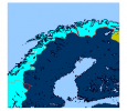
Provinces and Lands of Sweden. Note that the land corresponding to the modern Finnish regions of Ostrobothnia, Central Ostrobothnia and South Ostrobothnia were part of the Swedish province of Ostrobothnia but unlike the rest of the province, part of the Österland land (in any case the border there is marked different). Ingria, Livonia and Estonia were dominions and not provinces proper but have been added nevertheless.
A way to upload the full map here is to open the DA map in another tab and copy the link to that file.
The Swedish-Norwegian border was largely undefined until the Strömstad treaty 1751 so for example the area in the north on this map around Enare lake wasn’t Swedish until then. I made a edit showing the areas where there was border disputes between Denmark-Norway and Sweden here.
Sources for this:

Strömstadstraktaten – Wikipedia
Grensetraktaten av 1751 – Wikipedia
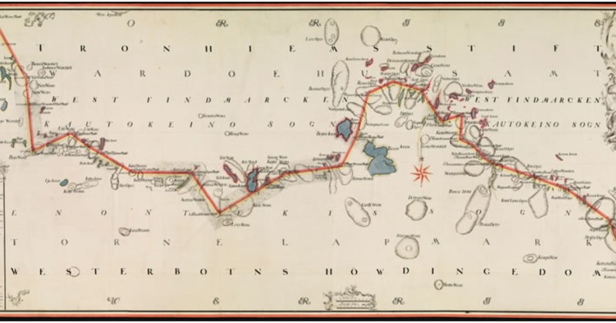
Grensearkiv ca. 1750
Dokumenter som gjelder riksgrensen er viktige vitnesbyrd om norsk historie og om Norge som stat. Mellom Norge og Sverige ble riksgrensen fastlagt allerede i 1751, og den gjelder fortsatt. Den omfatter også dagens grense mot Finland, som i 1751 var en del av Sverige.
Attachments
Patch for the Carolingian Kingdom of Italy? Preferably at 867, when Lothringia was still a thing
Share: