damein fisher
Banned
Interesting, but I suspect that should be "Caste War," not "Chaste War"?
Yes, that was a spelling error, I thought it was chaste.
Interesting, but I suspect that should be "Caste War," not "Chaste War"?
Thank you for fighting the good fight! Is this meant to be historical?
Personally I’m more annoyed by the fact that seemingly every map ever just labels Gondwana as “various states and tribes.” I suppose that area was just wholly at a different level of development than the rest of India?
Needs smaller Russia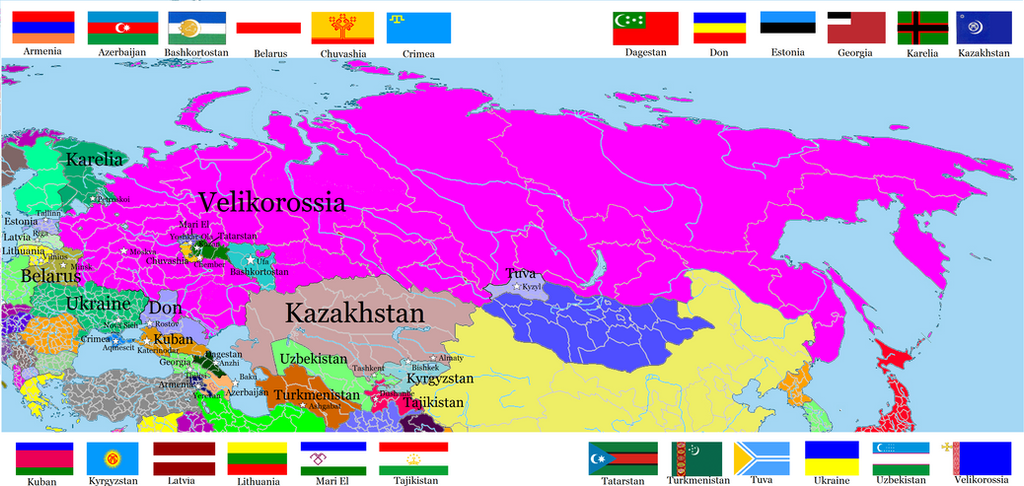
Post-Soviet Nations in my Velikorossia Unverse (where Bolshevik national politics goes a little different, lead to RSFSR collapsed in 1936).
some notes:
1. Königsberg goes to Poland after WWII, not to USSR. But USSR took Polish sities of Helmno, Belostok and Przemysl.
2. Moldova was reunited vith Romania in 1992, during the bloodycollapse of the Soviet Union
3. Crimea is mostly Tatar.
4. Mari El is partly-recognized state
5. There was no CIS or other post-soviet nations associations.
Kingdom of Haiti and Republic of Haiti:

I do find it a bit ironic that the first step in expanding the Soviet Union in this artist's eyes would be to build cathedrals everywhere.
Thailand or Khmer maybe?I am kinda at a standstill for ideas. What is a nation you haven't seen given a good wank either ever or in a long time? Ill try to make the map as realistic as possible.
Thank you all for the great ideas.
Cold War between Great Perm, the Central African Empire, and West Florida, while the regional powers of Tuva, Kalmykia, the Boer states, Oman, Pergamon, Pontus, and Thailand battle it out in the middle.Try all of the above, simultaneously.
The map doesn't look too bad, but it really needs a scale, and while the concept is good, you don't seem to have a particularly good grip on the issues behind the sectarian divide. The Unionists still see themselves as British - the biggest difference between them and the migrants is that the migrants would probably be more secular, and non-sectarian and would want to vote for mainland parties. Most Unionists in South and West NI would not consider "Becoming" Nationalist, in the same way indian people don't wake up and decide to become Pakistanis.This is very loosely based on recent rumors about Northern Ireland potentially remaining within the EEA or even EU while the rest of Britain exits (sadly the DUP isn't on board atm). Once that agreement is reached, the following things happen over the next 20 years:
-Many banks and businesses move from London or other cities on the island of Britain to Belfast and its suburbs (Antrim, Bangor, etc).
-There's a large wave of emigration from Britain proper to Northern Ireland associated with these businesses. 80-90% of the migrants holding British passports are Remainers. About 15% of the migrants are from elsewhere in the EU, particularly Poland.
-Northern Ireland sees Sunbelt-like population growth of 3-5% per year initially, tapering off after about 10 years but equating to a 50-60% increase in the resident population over 2019.
-Many of the British migrants do not embrace or take sides in the national divide, instead identifying as European. At the same time, Northern Irish identity increases significantly, particularly in sought-after coastal towns and scenic rural areas that are either too affluent to care about sectarianism or associate being "British" with gentrification.
-By 2039, the 'national identity' map of Norn Iron looks like this:
Nonsectarian identifies (in yellow) such as "Northern Irish" or "European" have grown substantially. A plurality of people in four districts (yellow) identify in a nonsectarian fashion.
The large-scale influx from mainland Britain has resulted in a significant increase in "British" identity (blue) in Belfast and its surrounding areas, but most of the "New British" are secular and apathetic to the region's divide, instead being lured to Northern Ireland by job opportunities (often in finance).
Nationalists/"Irish" (green) have continued to grow in population in the south and west as they had in prior censuses, partly due to a growing Roman Catholic population but partly also due to former unionists becoming disaffected with the influx of mainlanders turning Belfast into "Little London".

WE NEED MORE SWITZERLAND WANKS!Only on alternatehistory.com is this a perfectly normal, socially acceptable thing to say.
WE NEED MORE SWITZERLAND WANKS!
WE NEED MORE SWITZERLAND WANKS!

You have the right ideaWE NEED MORE SWITZERLAND WANKS!
Would it be worth creating a "wank" thread?
Everytime I see Belarus in an über Russia I get a little sadder.My current work-in-progress
As you can see it's a modest Russian Federation wank. The map is mostly finished, though I still have to write small TL, description, do legend, etc. Hopefully I'll finish it tomorrow
Not meaning to criticise or be negative, I just think it's funny that even in a Swiss world wank the only country that survives is the US analogue, and even that US analogue is wanked.
There's nothing wrong with Americawanks but I swear to god, even supposed America screws manage to wank the USA.