Map Thread XVII

Status
Not open for further replies.
This is an awe-inspiring map.

Shit, that is a big image!

Second triumvirate is a neat concept for sure, allows for a world that seems to be split into 4 major power block's with them grouping into just two.

Is the POD during or before the second world war?

So Mars has never really kicked terraforming into gear? Thats
disappointing.

Seems like the triumvirate are a group of assholes though.

All in all thats an
awesome map with great detail throughout the solar system. Great stuff!

Thank you!

The PoD is pretty vague, but it's in the 1930s. If you can guess it, you get a prize!*

*no physical prize promised. terms and conditions may vary by state/planetary body/supraplanetary coalition.
 

Deleted member 82118

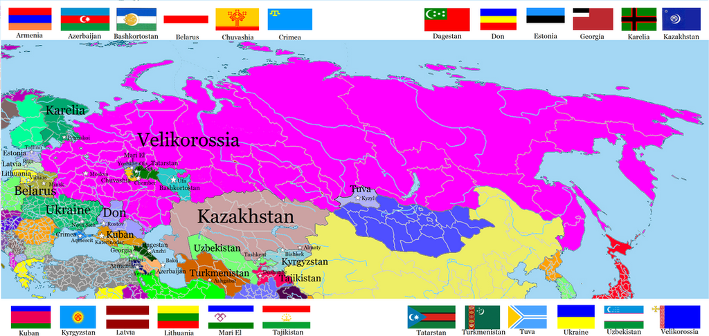
velikorossia_and_other_post_soviet_states_by_randaglar-dbvqxsy.png

Post-Soviet Nations in my Velikorossia Unverse (where Bolshevik national politics goes a little different, lead to RSFSR collapsed in 1936).
some notes:
1. Königsberg goes to Poland after WWII, not to USSR. But USSR took Polish sities of Helmno, Belostok and Przemysl.
2. Moldova was reunited vith Romania in 1992, during the bloodycollapse of the Soviet Union
3. Crimea is mostly Tatar.
4. Mari El is partly-recognized state
5. There was no CIS or other post-soviet nations associations.
 
Quick map.

Territorial expansion of the Republic of Louisiana (from 1871 to 1902) and administrative division of country.
Maybe I'll do bigger map or something related to this world.

louisiana.png
 
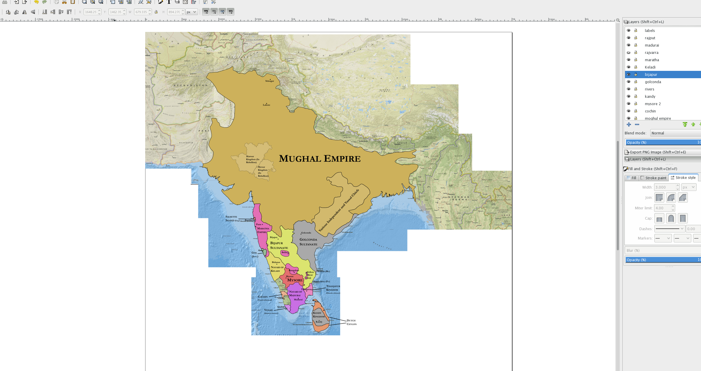
Frustrated by a lack of good India maps, I am creating a map of India in 1680. Unfortunately, information on small Kerala states is hard to come by and I'm unsure of my borders around the Deccan sultanates, so this is still a work in progress.

map_of_india__1680__in_progress__by_fjihr-dbvre4c.png
 
I am kinda at a standstill for ideas. What is a nation you haven't seen given a good wank either ever or in a long time? Ill try to make the map as realistic as possible.
 
Frustrated by a lack of good India maps, I am creating a map of India in 1680. Unfortunately, information on small Kerala states is hard to come by and I'm unsure of my borders around the Deccan sultanates, so this is still a work in progress.

map_of_india__1680__in_progress__by_fjihr-dbvre4c.png
Thank you for fighting the good fight! Is this meant to be historical? Personally I’m more annoyed by the fact that seemingly every map ever just labels Gondwana as “various states and tribes.” I suppose that area was just wholly at a different level of development than the rest of India?
 
Thank you for fighting the good fight! Is this meant to be historical? Personally I’m more annoyed by the fact that seemingly every map ever just labels Gondwana as “various states and tribes.” I suppose that area was just wholly at a different level of development than the rest of India?
Still is. The government's been doing its damnedest to "develop" the area for a while now, and has mostly pacified the Maoist reaction.
 

fashbasher

Banned
This is very loosely based on recent rumors about Northern Ireland potentially remaining within the EEA or even EU while the rest of Britain exits (sadly the DUP isn't on board atm). Once that agreement is reached, the following things happen over the next 20 years:

-Many banks and businesses move from London or other cities on the island of Britain to Belfast and its suburbs (Antrim, Bangor, etc).

-There's a large wave of emigration from Britain proper to Northern Ireland associated with these businesses. 80-90% of the migrants holding British passports are Remainers. About 15% of the migrants are from elsewhere in the EU, particularly Poland.

-Northern Ireland sees Sunbelt-like population growth of 3-5% per year initially, tapering off after about 10 years but equating to a 50-60% increase in the resident population over 2019.

-Many of the British migrants do not embrace or take sides in the national divide, instead identifying as European. At the same time, Northern Irish identity increases significantly, particularly in sought-after coastal towns and scenic rural areas that are either too affluent to care about sectarianism or associate being "British" with gentrification.

-By 2039, the 'national identity' map of Norn Iron looks like this:

Nonsectarian identifies (in yellow) such as "Northern Irish" or "European" have grown substantially. A plurality of people in four districts (yellow) identify in a nonsectarian fashion.

The large-scale influx from mainland Britain has resulted in a significant increase in "British" identity (blue) in Belfast and its surrounding areas, but most of the "New British" are secular and apathetic to the region's divide, instead being lured to Northern Ireland by job opportunities (often in finance).

Nationalists/"Irish" (green) have continued to grow in population in the south and west as they had in prior censuses, partly due to a growing Roman Catholic population but partly also due to former unionists becoming disaffected with the influx of mainlanders turning Belfast into "Little London".
0DrZtaN.png
 
fU7ie.png
[My First Battle map with Paint.net. Not quite that happy with it, but it's bad enough to scrap, so here it is]
Starting in 1851, the Third Anglo American war was a continuation of the Yucatan Chaste War. At first, the war was showing promise for the recently annexed Yucatan, with the Americans occupying the Northern Districts of Merida, Izamal and Vallidolid and establishing the State of Yucatan [Ruled by a small white elite], with the Southern Districts becoming the Cempeche Territory. The Chaste war would continue until the Briitsh supported the Mayan Cruzob State in 1851.

This would go on to be the tipping point for the US. Since the Great Lakes War [OTL War of 1812], Tensions between the nations had risen to a severe level with the most recent keg being the Oregon Country in the North. Promising annexation of British Honduras to Guatemala, the war became a fight of the British Empire and Cruzob versus Guatemala and the United States.

While short, at the time this would be the deadliest war in American History until the Civil War, with over Two hundred thousand dead. Backed with the entirety of the British West Indies, American Military occupation of the Cempeche Territory was pushed to the coast and in some ares, off land. As the war became bloodier, the Mexican American War was beginning to spark from Mexican Aggression, the US needed to focus and let go of it's pride.

Meeting in Montpellier France, negotiations occurred for a ceasefire of the War. Originally, the US desired a Oregon border of the Fraser River, however this was off the table and the US agreed to purchase a strip of land Below the Columbia and Spokane Rivers for $4 million. The Southern Border however was a much harder bargain. Cruzob claimed the whole peninsula, while the British argues for the American established Campeche Territory. Eventually the Borders seen above where chosen. This is how the situation would remain for over half a century.
 
Top
Status
Not open for further replies.
Top