Looks like he used Atlas colors.Maybe they're cities?
You are using an out of date browser. It may not display this or other websites correctly.
You should upgrade or use an alternative browser.
You should upgrade or use an alternative browser.
Alternate Electoral Maps II
- Thread starter Aaaaasima
- Start date
- Status
- Not open for further replies.
Threadmarks
View all 43 threadmarks
Reader mode
Reader mode
Recent threadmarks
Pericles-Obama landslide in 2008 Pericles-Obama does better in 2012 Tex Arkana-Carter runs a better campaign in 1976 and picks Frank Church as his running mate, winning in a landslide. DPKdebator-Trump landslide in 2016 wildviper121-Trump landslide based off of someone's Campaign trail game DPKdebator-The worst you can do as Hillary Clinton in the campaign trail game TheSaint1950-Last gallup poll in 1948 is right jonnguy2016-Trump self-sabotageWV would've gone Republican then.Looks like he used Atlas colors.
Gentleman Biaggi
Banned
I don't know why I made this. It will probably never make sense.
But....
Democrat 350 EVs
Republican 188
If you wanna make some reasoning why this would ever happen, sure, do whatever you want.
Well, richer coastal states trend democratic (on average) more and more every election (see Georgia and NC), while poorer interior states trend republican more and more every election (Minnesota, Ohio,)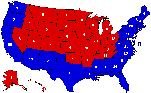
I don't know why I made this. It will probably never make sense.
But....
Democrat 350 EVs
Republican 188
If you wanna make some reasoning why this would ever happen, sure, do whatever you want.
We probably will never see a carbon copy of that map, but come the mid to late 2000s we could be seeing something similar
Carrying over from my work on US Election Atlas, I am posting this county map here:
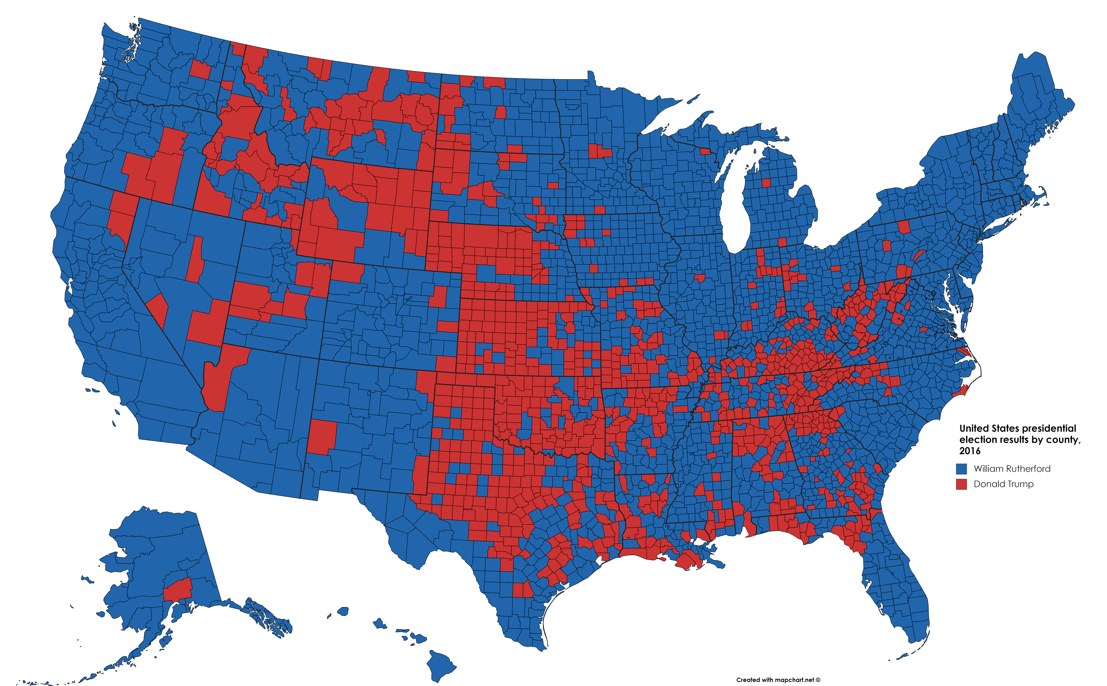
The map represents a scenario based off this Campaign Trail game: https://www.americanhistoryusa.com/campaign-trail/game/528280. Every state goes Democratic except for Wyoming and Oklahoma. I have been trying to determine how congressional districts in each state would go, based off this map.
Also, what would the breakdown of each demographic look like? How would whites be voting in each state? Nationwide? What about minorities? Does the map reasonably depict the closeness of some states, such as Wyoming, Oklahoma, Kentucky, Tennessee, Alabama, and Arkansas?
Gentleman Biaggi
Banned
Yeah, the main problems are NH, WV, Hawaii, and Illinois.Well, richer coastal states trend democratic (on average) more and more every election (see Georgia and NC), while poorer interior states trend republican more and more every election (Minnesota, Ohio,)
We probably will never see a carbon copy of that map, but come the mid to late 2000s we could be seeing something similar
Last edited:

Interesting idea, but not really. Sanders wouldn't win Mississippi, Montana and Kentucky while losing DC and RI.Trump vs. Sanders vs. Bloomberg?
Not to mention, Georgia and Louisiana.Interesting idea, but not really. Sanders wouldn't win Mississippi, Montana and Kentucky while losing DC and RI.
Trump vs. Sanders vs. Bloomberg?
Not to mention, Georgia and Louisiana.
Okay, here is the solution.
R: Bush / Kasich (not very popular republicans)
D: Manchin (or Edwards) / Gabbard (democrats popular among conservatives that could flip MS, KY, GA...)
I: a liberal candidate unsatisfied with democratic nominees. Could be Bloomberg.
Yes but like you said it's weird as hellWhich map are you referring to, the one that has all of Appalachia going blue?
I could see NH going Blue, but I'd be surprised if West Virginia did. I think Nevada will stay bluer than Arizona. So make Hawaii, Nevada and Illinois Blue and West Virginia Red and I can easily imagine it for the 2032 election (with someone on the Democratic ticket from Pennsylvania).Yeah, the main problems are NH, WV, Hawaii, and Illinois.
Looks like he used Atlas colors.
I actually don't know whether the colors are the standard red/GOP blue/Democrat or the other way around... like I said, I was a bit drunk when I made this map.
Yes but like you said it's weird as hell
Yeah, I don't think this kind of map was ever possible or will ever be possible.
Carrying over from my work on US Election Atlas, I am posting this county map here:
The map represents a scenario based off this Campaign Trail game: https://www.americanhistoryusa.com/campaign-trail/game/528280. Every state goes Democratic except for Wyoming and Oklahoma. I have been trying to determine how congressional districts in each state would go, based off this map.
Also, what would the breakdown of each demographic look like? How would whites be voting in each state? Nationwide? What about minorities? Does the map reasonably depict the closeness of some states, such as Wyoming, Oklahoma, Kentucky, Tennessee, Alabama, and Arkansas?
Posting this again so that people can see it.
Well for congressional districts, the question is whether the Republicans can meet in a regular size coat closeto or if they need a larger one. If the State of Wyoming goes Republican then the congressional district is Republican. Oklahoma is probably something like 3R, 2D. Unclear whether the large Nebraska congressional district is R or not. Alabama probably has 2 R districts. Maybe one in West Virginia and definitely the one far Eastern Tennessee. I'm guessing one in the Texas northern Panhandle and maybe 3-4 more. So 12-15 Republicans(?) total. So the larger coat closetPosting this again so that people can see it.
IFwanderer
Banned
If you flipped Oregon and Nevada, you could have California being the tipping point state.A narrow GOP victory, but a very odd electoral map for sure.
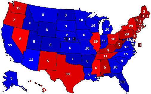
West Virginia and Vermont are the most Democratic states. Utah and Idaho are the most GOP.
Well for congressional districts, the question is whether the Republicans can meet in a regular size coat closeto or if they need a larger one. If the State of Wyoming goes Republican then the congressional district is Republican. Oklahoma is probably something like 3R, 2D. Unclear whether the large Nebraska congressional district is R or not. Alabama probably has 2 R districts. Maybe one in West Virginia and definitely the one far Eastern Tennessee. I'm guessing one in the Texas northern Panhandle and maybe 3-4 more. So 12-15 Republicans(?) total. So the larger coat closet
Some of those are pretty obvious to me, such as Wyoming. In Oklahoma, I know for a fact that the Eastern District would go Democratic, and so would the Oklahoma City one, while the Tulsa and the Oklahoma Panhandle districts, and probably the southwestern one (with Comanche County), would be Republican. In Alabama, I would imagine that the Mobile-Baldwin County district might be Republican, and certainly the one including the Birmingham suburbs. Democrats would carry two of West Virginia's three districts, and the two eastern Tennessee districts would certainly be Republican. But the Nebraska one is up to debate, and there are also districts elsewhere in the South, in Utah, and in Kentucky that I am not sure about.
Another alternate 1844, this time with Van Buren as the Democratic nominee and John Tyler running on the Democratic-Republican ticket as the pro-annexation candidate.
The House chooses Tyler while the Senate chooses Frelinghuysen.
The House chooses Tyler while the Senate chooses Frelinghuysen.
Threadmarks
View all 43 threadmarks
Reader mode
Reader mode
Recent threadmarks
Pericles-Obama landslide in 2008 Pericles-Obama does better in 2012 Tex Arkana-Carter runs a better campaign in 1976 and picks Frank Church as his running mate, winning in a landslide. DPKdebator-Trump landslide in 2016 wildviper121-Trump landslide based off of someone's Campaign trail game DPKdebator-The worst you can do as Hillary Clinton in the campaign trail game TheSaint1950-Last gallup poll in 1948 is right jonnguy2016-Trump self-sabotage- Status
- Not open for further replies.
Share: