You are using an out of date browser. It may not display this or other websites correctly.
You should upgrade or use an alternative browser.
You should upgrade or use an alternative browser.
The Q-BAM Improvement and Core Thread
- Thread starter iori
- Start date
Alex Richards
Donor
How's the work on Chinese rivers so far @Alex Richards? I suppose it's infuriating in the mess of contradicting infos? Because it certainly looked this way to me.
Frustrating, mainly due to the fact that many of the Chinese province articles on Wikipedia have nice maps like this which can with some effort be transferred to QBAM, and others have maps like this which obviously can't.
So after three days I managed to do a patch for Antarctica, including mainland Ice Caps, some coastline fixes, extra islands and fixed ocean ice caps to their current extension.
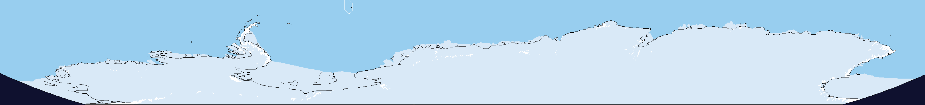
Very nice, but it still has problems, namely the fact that the edges still don't match on either side of the map, eg;
(uses the old map I know, but it illustrates my point)
Apart form that though, its still a good map (and saves me work on my ice sheet patches, so thanks for that).
Also, I'd use the unclaimed land green for the non glaciated bits.
Very nice, but it still has problems, namely the fact that the edges still don't match on either side of the map, eg;
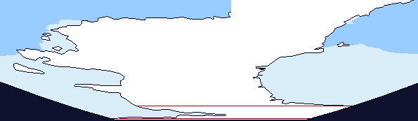
(uses the old map I know, but it illustrates my point)
Apart form that though, its still a good map (and saves me work on my ice sheet patches, so thanks for that).
Also, I'd use the unclaimed land green for the non glaciated bits.
Yeah, I noticed the fail in Antarctica, could you patch it for me if you don't have lots of work to do?
Anyhow, about the Green part, there are claims in Antarctica, which is pretty confusing given the term "Unclaimed". Anyhow I'll paint it green rn.
I tought Green represented areas without state (would it be early state on a chiefdom/formation/nation model)?Anyhow, about the Green part, there are claims in Antarctica, which is pretty confusing given the term "Unclaimed". Anyhow I'll paint it green rn.
Yeah, I noticed the fail in Antarctica, could you patch it for me if you don't have lots of work to do?
Anyhow, about the Green part, there are claims in Antarctica, which is pretty confusing given the term "Unclaimed". Anyhow I'll paint it green rn.
I would, If I didn't have other stuff to do (hence the really late reply).
I always thought that the green was unadministered, not unclaimed, ie, a country could claim a load of desert/tundra/jungle ect but couldn't actually control it, as well as just showing the lack of any states in the area.
Alex Richards
Donor
As a bit of a progress update, Chinese rivers are redrawn for every province except Yunnan, Tibet, Qinhai and Xinjiang.
As a bit of a progress update, Chinese rivers are redrawn for every province except Yunnan, Tibet, Qinhai and Xinjiang.
As a bit of a progress update, Chinese rivers are redrawn for every province except Yunnan, Tibet, Qinhai and Xinjiang.
Ten Thousand Years! Ten Thousand Years! Ten Thousand Years!
Best of luck with Yunnan, Tibet, Qinghai and Xinjiang.
Some of their areas hopefully won’t be too hard. Particularly if you decide not to show endorheic lakes, makes doing Xinjiang a whole lot easier.
")
I don’t know if you like to work to music, but if you do hopefully this could be something. Anyways, this auspicious occasion calls for some good music
Spring on the Moonlit River 春江花月夜
Alex Richards
Donor
Ten Thousand Years! Ten Thousand Years! Ten Thousand Years!
Best of luck with Yunnan, Tibet, Qinghai and Xinjiang.
Some of their areas hopefully won’t be too hard. Particularly if you decide not to show endorheic lakes, makes doing Xinjiang a whole lot easier.
I don’t know if you like to work to music, but if you do hopefully this could be something. Anyways, this auspicious occasion calls for some good music
Spring on the Moonlit River 春江花月夜
I'm not adding any more lakes just for the moment.
That said, I'm working on historical coastlines of China, which are very annoying to have carthographical (usable at least) sources on, but easier to drawn than in Europe (The Dreaded Frisian Coast ™)I'm not adding any more lakes just for the moment.
Which of course brings the topic of changing Chinese riverbeds.
Alex Richards
Donor
That said, I'm working on historical coastlines of China, which are very annoying to have carthographical (usable at least) sources on, but easier to drawn than in Europe (The Dreaded Frisian Coast ™)
Which of course brings the topic of changing Chinese riverbeds.
We'll cross that bridge when we come to it.
Just Xinjiang to do now.
I wondered what I'll eat this evening. No more.We'll cross that bridge when we come to it.
Ah, sorry! Meant lakes. That should teach me not to write on coffee… Maybe I’ll just blame it on English being the world’s lingua franca or something like that…I'm not adding any more lakes just for the moment.
Ah, but I also see that you’ve already chosen.@LSCatilina Well since half the rivers in Xinjiang are rather ephemeral...
Anyways, since LSCatilina is doing historical Chinese coasts, would anyone be interested in… historical Southeast Asian coasts?
It’s not much, but could help if anyone’s interested in maps for the region for their TLs and whatnot. You might be surprised by how much the coastline has changed in some parts.
I’m also planning to make a map of the Japanese domains under Tokugawa. I’ve already got some nice and decent maps, but if anyone has something they think could help, I humbly ask if you could share, it would be much appreciated.
Alex Richards
Donor
Ah, sorry! Meant lakes. That should teach me not to write on coffee… Maybe I’ll just blame it on English being the world’s lingua franca or something like that…
Ah, but I also see that you’ve already chosen.
Anyways, since LSCatilina is doing historical Chinese coasts, would anyone be interested in… historical Southeast Asian coasts?
It’s not much, but could help if anyone’s interested in maps for the region for their TLs and whatnot. You might be surprised by how much the coastline has changed in some parts.
I’m also planning to make a map of the Japanese domains under Tokugawa. I’ve already got some nice and decent maps, but if anyone has something they think could help, I humbly ask if you could share, it would be much appreciated.
Historic coastal patches are always appreciated.
Anyways, since LSCatilina is doing historical Chinese coasts, would anyone be interested in… historical Southeast Asian coasts?

As for South-East Asian coast, I did some modification for India and Mesopotamia-Arabia, and of course with @Alex Richards, in Western and North-Eastern Europe, but I don't think I've anything on Japan.
Share: