Map Thread XV

Status
Not open for further replies.
A stalemate. Now, all factions vie for power, both on Earth and on the "Gloom" which is a near Earth-like planet.
How did Skalhin, Alantic Canada, the North American Great Lakes and other odd geographical similarityd end up on Gloom. :rolleyes:
Also that's a rather depressing name for a planet.:(
 

Deleted member 67076

The WIP continues
D1lUfCs.png
 
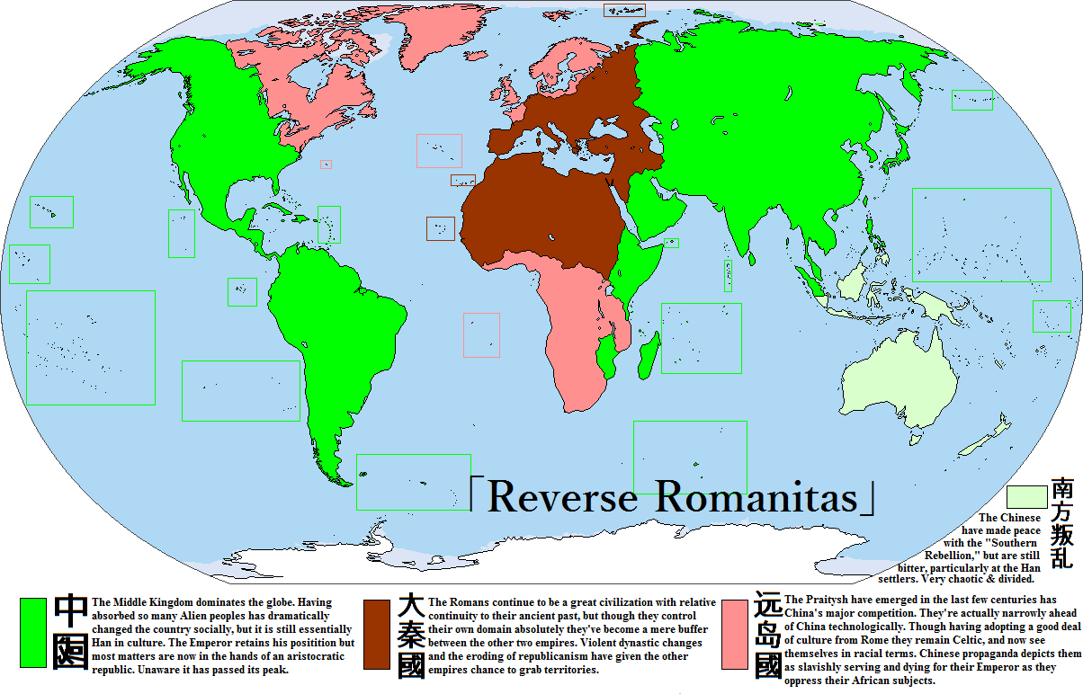
Quick and dirty; full of gigantic space-filling blobs, but that's kind of the point. A reverse of Romanitas; https://www.alternatehistory.com/fo...-revealed-the-atl-map-database.140896/page-39 by Sophia McDougall.

reverse_romanitas_by_goliath_maps-db4w9z4.png

It's a rather dystopic world. China evolved early on to be huge into incorporating different cultures (by this point Korea and Japan are seen as fully Han) and educated citizens from the corners of the empire found themselves able to advance in the Confucian bureaucracy tests. By allowing for regional autonomy (after a few centuries of holding down conquered territories tight) China has *mostly* crushed all colonial rebellions. Not everything is peachy fine; though the Romans (China's old enemy) are no longer a threat, a Britain which never experienced Roman colonization or Germanic invasions has become quite the threat. The isles of Praitya, as they call themselves, are big into poetry, nature-worship, advancing their wondrous electronic and mechanical grid systems, and ritualized beheading of criminals and the unwanted. Slavery is still practiced, though there's been talk in China of ending it. Nations have industrialized, but the affects have largely missed the still (literally) unwashed masses. Christianity and Abrahamic religions have mostly been snuffed out. In a largely illiterate world (China's complicated characters are actually not that much harder than the complex system of Latin, Runes, and locally-developed letters than the Praitysh write in any direction with) the masses are unaware of the impending dangers of the nuclear race between China and Praitya.

The map depicts the world in 2003 (A.D.) shortly before Rome and Praitya go to war.
 

fashbasher

Banned
Another one shot map: France commits (at the very best) cultural genocide across much of Africa in the hopes of establishing a French presence from the Southern Mediterranean to Cote d'Ivoire. The map below shows the new départements that they carved out in Africa (France Méditerranée sp?, or "Mediterranean France") after taking care of the natives. All of the names have been altered to mask their non-French origins as if they were place names in France proper (note *M'zab, *Ghardaïa, *Tindouf, *Rosso, *Ouagadougou, *Loos Islands, *Conakry, and *Abidjan). Light blue represents "independent" Francophone states.

JbgW4Xd.png

ed: I clearly have a problem with coming up with too many great one-shot ideas vs. building 'em into a timeline.
 
Last edited:
Another one shot map: France commits (at the very best) cultural genocide across much of Africa in the hopes of establishing a French presence from the Southern Mediterranean to Cote d'Ivoire. The map below shows the new départements that they carved out in Africa (France Méditerranée sp?, or "Mediterranean France") after taking care of the natives. All of the names have been altered to mask their non-French origins as if they were place names in France proper (note *M'zab, *Ghardaïa, *Tindouf, *Rosso, *Ouagadougou, *Loos Islands, *Conakry, and *Abidjan). Light blue represents "independent" Francophone states.

JbgW4Xd.png

ed: I clearly have a problem with coming up with too many great one-shot ideas vs. building 'em into a timeline.

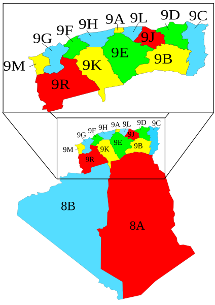
Um, you do realise that the areas (1) and (2) eventually had fifteen departments by the time Algeria became independent IOTL.

424px-Map_showing_the_D%C3%A9partements_of_Algeria_from_1962-1968_and_1968-1974.svg.png

Algeria_departments_1957-1974.png


Heck, area (1) started off as three departments.

1900big.jpg

algerie.jpg
 
Indonesian Malaya but Separate North Borneo

I kinda get the aesthetic appeal behind this arrangement, but more likely it will be the other way around(especially with the current push to move the capital to Kalimantan). Even if this happens I doubt it won't fall to Indonesian orbit, being geographically more exposed to Indonesian territory then the Malay Peninsula.

Also why the hell is Eritrea still a thing? :p
 
Last edited:
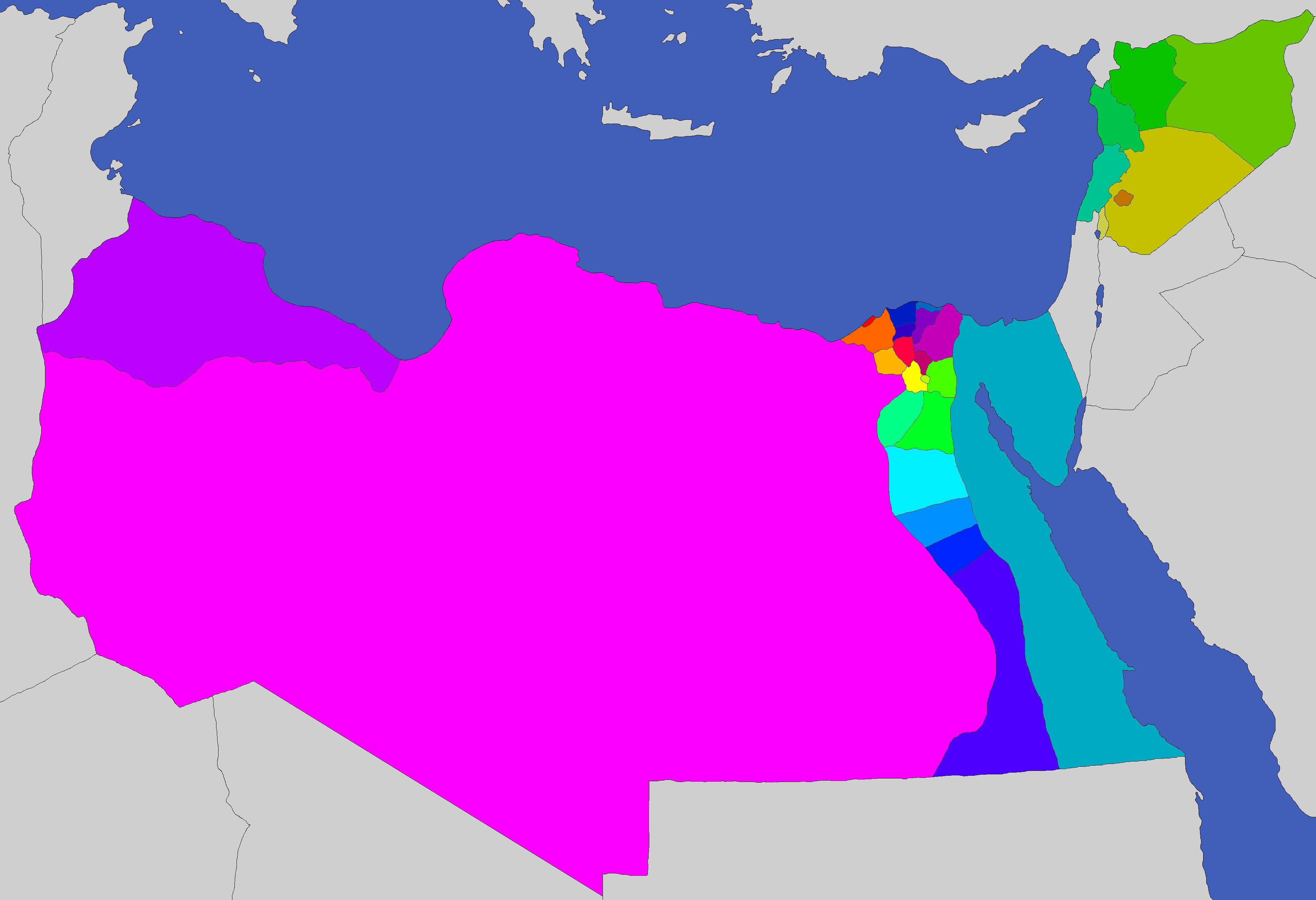
greater_united_arab_republics_by_spiritswriter123-db4x205.png

Map that probably doesn't deserve to be posted. Oh well

Anyways, the basic idea is that the Syrian-Egyptian union of the United Arab Republic/ The Syrian-Egyptian-Libyan Federation of Arab Republics were more successful. Along the way Lebanon (and Libya, depending on the scenario) join, and the states became rebalanced so that population per district is fairly equal (somewhere between 3-6 million).

There were 3 special status cities in the UAR: Cairo (capital), Damascus ('co-capital'), and Alexandria.

Through all this though, there's still much discontent. It's obvious that higher-ups only care up the Nile and Delta territory, ignoring the will of Libya and Levant. At some point, the states of Tripolitania+Libyan Desert, Lebanon+Latakia-Tartus, and the remains of Syria would break off, leaving Egypt with mostly the Nile, but even though they lost 3/4th of the territory, they still control 2/3rds of the former population.
 

Deleted member 67076

Argentina has the Malvinas, but not Tierra del Fuego or the Georgias/Sandwich islands?... interesting tradeoff :p

Also, Brazil seems too quiet for a future scenario...
No Britscrew is complete without losing those empty Islands and rusty naval bases. :p

Oh I haven't gotten to Brazil yet, or most of South America. Sort of at a loss at how the Indo/Chinese spheres will be carved

I kinda get the aesthetic appeal behind this arrangement, but more likely it will be the other way around(especially with the current push to move the capital to Kalimantan). Even if this happens I doubt it won't fall to Indonesian orbit, being geographically more exposed to Indonesian territory then the Malay Peninsula.

Also why the hell is Eritrea still a thing? :p
Oh ok. I can change it.

Eritrea is a thing because Ethiopia needs more votes in African Union to influence policy. And also because the EAF and friends keep blocking a wholesale annexation through legal means. De facto though, Eritrea exists only on paper. Much like Niger, Libya, Mauritania, and Chad.
 
I had an idea where the modern US is ISOTed to the old world, So I did a thing where I transposed 2000 municipalities from the lower 48 states onto positions in the Old World: https://drive.google.com/open?id=1kf1XnTZVUjwcpT7S6xIoQv_8944&usp=sharing

The map is searchable. Latitudes are exactly the same for all cities, but longitude is... funny. I tried to (1) preserve relative longitudes so that a city to the east would stay to the east and vice-versa, and (2) position cities so that they ended up in a place that's survivable and not in the middle of a desert or ocean. To that end I used a spreadsheet with the latitudes and longitudes of both old world cities and new world cities and did a bit of matching. However, my goals began to contradict each other and I ended up with some weird results, like some cities in Maryland being west of some cities in Iowa. Even so, the east coast is on the east coast and the west coast is on the west coast, and cities on water are not too far from land.

If I had to pick transposition areas for Alaska and Hawaii, I'd probably go with Scandinavia and the Caribbean, respectively. The Caribbean isn't in the old world, but then again Hawaii isn't in North America.


As an example, here is where my home city of Cleveland ended up, on the Macedonia-Bulgaria border:
Clevelandtransposition.png


The city on the upper right is Burbank, Illinois, which is decidedly not northeast of where I am.
 
I had an idea where the modern US is ISOTed to the old world, So I did a thing where I transposed 2000 municipalities from the lower 48 states onto positions in the Old World: https://drive.google.com/open?id=1kf1XnTZVUjwcpT7S6xIoQv_8944&usp=sharing

The map is searchable. Latitudes are exactly the same for all cities, but longitude is... funny. I tried to (1) preserve relative longitudes so that a city to the east would stay to the east and vice-versa, and (2) position cities so that they ended up in a place that's survivable and not in the middle of a desert or ocean. To that end I used a spreadsheet with the latitudes and longitudes of both old world cities and new world cities and did a bit of matching. However, my goals began to contradict each other and I ended up with some weird results, like some cities in Maryland being west of some cities in Iowa. Even so, the east coast is on the east coast and the west coast is on the west coast, and cities on water are not too far from land.

If I had to pick transposition areas for Alaska and Hawaii, I'd probably go with Scandinavia and the Caribbean, respectively. The Caribbean isn't in the old world, but then again Hawaii isn't in North America.


As an example, here is where my home city of Cleveland ended up, on the Macedonia-Bulgaria border:
View attachment 315927

The city on the upper right is Burbank, Illinois, which is decidedly not northeast of where I am.
I'm so tempted to make a map out of this, showing the states and all.

Apparently I also now live Novorussiysk, along with half of my state. The other half is in Northern Italy. I guess the Great Migration saw the Minnesotan People turn into West and East Minnesotans :p
edit: correction, apparently there's a long line of Minnesota across Wallachia, Voivodina, and Slavonia, then there's also a couple in Kazakhstan. Man, if I do this, it's going to be so much fun
 
Last edited:
Another one shot map: France commits (at the very best) cultural genocide across much of Africa in the hopes of establishing a French presence from the Southern Mediterranean to Cote d'Ivoire. The map below shows the new départements that they carved out in Africa (France Méditerranée sp?, or "Mediterranean France") after taking care of the natives. All of the names have been altered to mask their non-French origins as if they were place names in France proper (note *M'zab, *Ghardaïa, *Tindouf, *Rosso, *Ouagadougou, *Loos Islands, *Conakry, and *Abidjan). Light blue represents "independent" Francophone states.

JbgW4Xd.png

ed: I clearly have a problem with coming up with too many great one-shot ideas vs. building 'em into a timeline.

Good idea but there should definitely be more départements.

Although those borders would make good régions of France, if France still ends up being divided into régions ITTL.

By the way, by "cultural genocide" do you mean that France treated the natives in the same way that they treated the Occitans? With education in French only, etc.

He says cultural genocide "at best", so presumably there was some ethnic cleansing or worse as well.
 
Top
Status
Not open for further replies.
Top