I might be able to get themDo you have each of the individual frames stored somewhere? No pressure if you don't. Good job!
You are using an out of date browser. It may not display this or other websites correctly.
You should upgrade or use an alternative browser.
You should upgrade or use an alternative browser.
Q-Bam Historical Map Thread
- Thread starter The Alternative
- Start date
-
- Tags
- historical maps q-bam
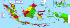
I made a patch for the Dutch East Indies in 1940-1941, showing the autonomous states and lower level subdivisions.
I'm pretty confident about most of the native states, although I'm not too convinced with New Guinea; the very few sources I found contradict each other, and I couldn't be sure about Kaimana's territorial extension; in the end I mostly followed the current regency's borders. New Guinea's subdistrict borders are mostly guesses too.
Also someone should look into what New Guinea's status really was; there was the Kaimana Kingdom, but the rest of the territory itself, while administered directly by the Dutch, was legally territory of the Sultanate of Tidore; although I could not find the extent of said claim.
Feel free to use and/or improve upon!
Last edited:
This is gorgeous 0:I made a patch for the Dutch East Indies in 1940-1941, showing the autonomous states and lower level subdivisions.
I'm pretty confident about most of the native states, although I'm not too convinced with New Guinea; the very few sources I found contradict each other, and I couldn't be sure about Kaimana's territorial extension; in the end I mostly followed the current regency's borders. New Guinea's subdistrict borders are mostly guesses too.
Also someone should look into what New Guinea's status really was; there was the Kaimana Kingdom, but the rest of the territory itself, while administered directly by the Dutch, was legally territory of the Sultanate of Tidore; although I could not find the extent of said claim.
Feel free to use and/or improve upon!
View attachment 906879
MS PaintWhat Drawings apps to you guys use for Q-Bam?
There are many programs you could use, any raster software will do: MS Paint, Paint.NET, GIMP, Adobe Photoshop, or similar.What Drawings apps to you guys use for Q-Bam?
Personally I've used Paint.NET and GIMP.
How long did the Farthings last for as relevant administrative divisions?View attachment 907944
here's a rough patch for the farthings and counties of Iceland, based on this and this
1988How long did the Farthings last for as relevant administrative divisions?
I am an Indonesian, and this is accurate map for Tidore. https://en.wikipedia.org/wiki/File:Sultanate_of_Tidore_in_1800.pngI made a patch for the Dutch East Indies in 1940-1941, showing the autonomous states and lower level subdivisions.
I'm pretty confident about most of the native states, although I'm not too convinced with New Guinea; the very few sources I found contradict each other, and I couldn't be sure about Kaimana's territorial extension; in the end I mostly followed the current regency's borders. New Guinea's subdistrict borders are mostly guesses too.
Also someone should look into what New Guinea's status really was; there was the Kaimana Kingdom, but the rest of the territory itself, while administered directly by the Dutch, was legally territory of the Sultanate of Tidore; although I could not find the extent of said claim.
Feel free to use and/or improve upon!
View attachment 906879
Though it was more suzerainty, so a legal fiction. The administrative divisions used weren't even considering Tidorean's claim, except during 1898 where they created Afdeeling Noord-Nieuw-Guinea (Manokwari), and Afdeeling West-En-Zuid-Nieuw-Guinea (Fakfak), though the last was more like Fak-fak other than in name, while the Zuid/Merauke part would be claimed in 1901 and directly ruled.
In others, I saw in accuracy. Like there were still some kingdoms in Bali, only Lombok was directly ruled in Nusa Tenggara. Tanah Bumbu was already directly ruled IIRC, while Karawang/Purwakarta was under Batavia. Also, I noticed that it used modern regency/city borders, while the districts (abolished) and subdistricts were moved between the regencies/cities. Surabaya and Bogor were dead giveaways.
Check out Indonesianhistory.info on wayback machine, Robert Cribb gave out a really nice map (though watermarked.
Hey everyone, long time no see.

I re-did my early ottoman patches, with some other goodies and of much higher quality. enjoy!
I re-did my early ottoman patches, with some other goodies and of much higher quality. enjoy!
Amazing. :3Hey everyone, long time no see.
View attachment 908621
I re-did my early ottoman patches, with some other goodies and of much higher quality. enjoy!
Updated New Guinea's divisions with your sources:I am an Indonesian, and this is accurate map for Tidore. https://en.wikipedia.org/wiki/File:Sultanate_of_Tidore_in_1800.png
Though it was more suzerainty, so a legal fiction. The administrative divisions used weren't even considering Tidorean's claim, except during 1898 where they created Afdeeling Noord-Nieuw-Guinea (Manokwari), and Afdeeling West-En-Zuid-Nieuw-Guinea (Fakfak), though the last was more like Fak-fak other than in name, while the Zuid/Merauke part would be claimed in 1901 and directly ruled.
In others, I saw in accuracy. Like there were still some kingdoms in Bali, only Lombok was directly ruled in Nusa Tenggara. Tanah Bumbu was already directly ruled IIRC, while Karawang/Purwakarta was under Batavia. Also, I noticed that it used modern regency/city borders, while the districts (abolished) and subdistricts were moved between the regencies/cities. Surabaya and Bogor were dead giveaways.
Check out Indonesianhistory.info on wayback machine, Robert Cribb gave out a really nice map (though watermarked.
And yeah, I mostly used current regency borders due to a lack of material showing concurrent district/subdistrict borders; I traced them from Hisatlas' maps, which showed correlation between colonial districts and current regencies.
Attached you can find where I got most of the subdivisions from:
Attachments
Last edited:
The current regencies and colonial ones are..well mostly still continuing to exist, yes. However it has almost completely different borders, due to districts and subdistricts being moved around. It's why I really recommend using Robert Cribb's maps as the base, as it's accurate per the 1930 division used for the last census of Dutch East Indies.Updated New Guinea's divisions with your sources:
snip
Oh yeah, I have a friend, his tweets also have some maps collected from various sources, https://fxtwitter.com/adepedia. but I guess you need to hunt around in the media, the latest he shared was the 1914 maps. Also another example, this thread has map of the 1942 Uleebalang in Aceh.
Javanese residencies in 1942: District borders in 1936, though there are changes after it: You can compare it to his spreadhseet of district borders in 1942:
Note, yes. I once asked general permission for whether I could share his twitter to everyone interested in Indonesian maps, and he said yes. I hope it's useful, I really appreciate your work. As the internal borders were pretty fluid, I would suggest to do the 1905 and 1930 (censuses, hence important), and 1942. Of course that's up to you
I am still working on the 1800 map, although I've been very very slow about it since I decided to redraw many of the borders (particularly the Indian princely states), I got busy with real life stuff, and I've just been burnt out. But progress continues still
I'm posting this because I've decided to do the same thing I do with the Holy Roman Empire, that is draw a colored border around them, to other countries. The basis being that these countries, like the HRE, are massively decentralized in some way but recognize some institution that they are a part of, informally or in name only. Maybe I could say it better, but I decided to go forward with this by adding the border to the Maratha Empire, Sikh Confederacy, and Ethiopia.
- The Maratha Empire at this point takes the 'confederacy' title by this point, which I think gets this border at the latest by November 18, 1772 when Madhavrao I died and the Maratha Peshwa's authority basically became a second thought in the minds of many rulers
- The Sikh Confederacy gets it from its inception since the Misls were all functionally independent, no official leader existed unlike in the Maratha and Holy Roman Empires, and these states had an extremely loose system of subordination, not uncommon in the subcontinent
- Ethiopia was undergoing the Zemene Mesafint which started either in 1769 at the earliest, 1771 as a possible date, and 1784 as the latest. This era was represented by feudal clans and princes competing for dominance over the Emperor of Ethiopia, who more often then not was a figurehead and incapable of asserting true authority.
The only one I don't know is Vietnam. While Vietnam was divided for over a century by the Trinh and Nyugen lords, I don't think it may constitute this border for them. This is partially why I'm asking, besides showing off my progress of course. What do you guys think?
Superb work, particularly in India!View attachment 910718
I am still working on the 1800 map, although I've been very very slow about it since I decided to redraw many of the borders (particularly the Indian princely states), I got busy with real life stuff, and I've just been burnt out. But progress continues still
I'm posting this because I've decided to do the same thing I do with the Holy Roman Empire, that is draw a colored border around them, to other countries. The basis being that these countries, like the HRE, are massively decentralized in some way but recognize some institution that they are a part of, informally or in name only. Maybe I could say it better, but I decided to go forward with this by adding the border to the Maratha Empire, Sikh Confederacy, and Ethiopia.
- The Maratha Empire at this point takes the 'confederacy' title by this point, which I think gets this border at the latest by November 18, 1772 when Madhavrao I died and the Maratha Peshwa's authority basically became a second thought in the minds of many rulers
- The Sikh Confederacy gets it from its inception since the Misls were all functionally independent, no official leader existed unlike in the Maratha and Holy Roman Empires, and these states had an extremely loose system of subordination, not uncommon in the subcontinent
- Ethiopia was undergoing the Zemene Mesafint which started either in 1769 at the earliest, 1771 as a possible date, and 1784 as the latest. This era was represented by feudal clans and princes competing for dominance over the Emperor of Ethiopia, who more often then not was a figurehead and incapable of asserting true authority.
The only one I don't know is Vietnam. While Vietnam was divided for over a century by the Trinh and Nyugen lords, I don't think it may constitute this border for them. This is partially why I'm asking, besides showing off my progress of course. What do you guys think?
Thank you!Superb work, particularly in India!
What is yours and other people's opinion on whether the border for Vietnam should be the standard dark grey border or the specific coloration?
Share: