What’s that little Chinese bit in north India?
December 2 1856, Battle of Ndondakusuka
You are using an out of date browser. It may not display this or other websites correctly.
You should upgrade or use an alternative browser.
You should upgrade or use an alternative browser.
Q-Bam Historical Map Thread
- Thread starter The Alternative
- Start date
-
- Tags
- historical maps q-bam
If you're talking about Delhi, then that was the final vestige of the Mughal EmpireWhat’s that little Chinese bit in north India?
Lots of small details in this map for those who are interested in even for more detail.

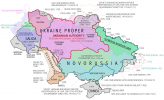
Novorossiya - Wikipedia
Attachments
I have been working on the Scramble for Africa timeline, and I was wondering if you guys would prefer me doing a more detailed, contextualized documenting or more generalized and shorter?


I have done more than this but I kind of realized I've already got 6000 words and I've only finished the Comoros and Madagascar's history, so I'd like to make this change and any other changes early on. I could also do both but it would take much longer
I have done more than this but I kind of realized I've already got 6000 words and I've only finished the Comoros and Madagascar's history, so I'd like to make this change and any other changes early on. I could also do both but it would take much longer
Personally I love detail but I'm not going to ask you to commit so much timeI have been working on the Scramble for Africa timeline, and I was wondering if you guys would prefer me doing a more detailed, contextualized documenting or more generalized and shorter?
View attachment 798898
View attachment 798900
I have done more than this but I kind of realized I've already got 6000 words and I've only finished the Comoros and Madagascar's history, so I'd like to make this change and any other changes early on. I could also do both but it would take much longer
I have been working on the Scramble for Africa timeline, and I was wondering if you guys would prefer me doing a more detailed, contextualized documenting or more generalized and shorter?
View attachment 798898
View attachment 798900
I have done more than this but I kind of realized I've already got 6000 words and I've only finished the Comoros and Madagascar's history, so I'd like to make this change and any other changes early on. I could also do both but it would take much longer
Seconded.Personally I love detail but I'm not going to ask you to commit so much time
Okay, gotta ask. Is that Mavia's Tanukhid domain?
January 16, 378: Siyaj K'ak' conquers Tikal
I'm not 100% on that Ireland. Did the four provinces exist during the 4th century?
Crazy Boris
Banned
Yep. I actually hadn’t heard about her before making this, interesting story.Okay, gotta ask. Is that Mavia's Tanukhid domain?
I'm not 100% on that Ireland. Did the four provinces exist during the 4th century?
Early Irish (and Celtic in general) history is difficult to figure out, and distinguish reality from legend, so I can’t say I’m 100% sure either, but from what I was able to gather, Niall of the 9 Hostages would have been high king (assuming the office existed at the time, though it’s generally agreed Niall himself existed), and based on that, I can at least be certain about Connacht, being his home kingdom, and Ulster, since his sons apparently invaded and broke it up into the smaller kingdoms we see later on (Tyrconnel, Tyrone, Aileach, etc.), and Leinster for similar reasons connected to the Ui Neill. As for Munster, I can’t remember exactly what I read about it pertaining to this period, maybe I just figured since the other three would have been around, Munster was likely too.
Crazy Boris
Banned
Quick little patch for the disputed area in the southern Andes between Argentina and Chile before 1902
Are there any "necessary" historical patches we need to start making that we don't have yet? Like, a list? If so, what are some ideas?
Maybe some of the noteworthy cessions of the Napoleonic Wars that did not last?Are there any "necessary" historical patches we need to start making that we don't have yet? Like, a list? If so, what are some ideas?
What's with Himyar having colonies in East Africa?.
January 16, 378: Siyaj K'ak' conquers Tikal
Thanks! Many, many thanks! I have been searching for such a patch for quite a while!View attachment 801268
Quick little patch for the disputed area in the southern Andes between Argentina and Chile before 1902

Also, a little note by me because I'm often times prone to being really precise with language.
I would not use the word "disputed" in this case, since the treaties that defined the limits, caused the problem and later solved it were caused more due to ambiguities and lack of decent geographical knowledge rather than any proper ambition. And even the treaties acknowledged this. Both states considered for decades after these territories as almost worthless and barely needing mentioning in any international relations. I would honestly call these as "ambiguous limits" rather than "overlapping/disputed claims". I would not really use red lines for this then, but then again, this is my interpretation of this.
The interesting thing is that the treaties are weird because there's not just a situation in which an interpretation, any interpretation of them, causes them to be benefiting A over B or the reverse, but they are in a strange limbo in which they either benefit both or neither due to the way the treaties contradict themselves rather than contradicting other treaties, previous or of later date.
The greatest example of this is that you have things like the "Line of the Waters" (La Línea de Aguas) which separates the basins of the Atlantic and the Pacific-headed rivers and the highest summit of the Andes not corresponding to each other when both were used to create the limit at the same time for the same areas. And neither country claimed one interpretation as more valid than the other in any official position, but rather, a mixture, an arbitrary mixture which favoured them. That, that the definitions were arbitrary, was even acknowledged in the very documents of both states.
Well, I'm not really sure anyone is going to find much joy in trawling through historical treaties, but I have a friend who has while studying (Chilean) law and he has told me these things. On the other hand, I'm not really sure if anyone who uses this patch will really take such a close look at things.
I hope I haven't bored anyone and that this whole little asterisk on the limits wasn't felt as an exercise in being pedantic.
Crazy Boris
Banned
What's with Himyar having colonies in East Africa?.
Those are Sarapion, Nikon, and Rhapta, less colonies and more trading outposts
Were they founded by Himyar?. I am pretty sure they developed by themselves.Those are Sarapion, Nikon, and Rhapta, less colonies and more trading outposts
Crazy Boris
Banned
Were they founded by Himyar?. I am pretty sure they developed by themselves.
Not as far as I know, but omniatlas puts them under Himyarite rule
I have read somewhere that the Azanian cities recognized a sort of nominal Himyarite overlordship but I assumed that would include the cities in Somalia as well.Not as far as I know, but omniatlas puts them under Himyarite rule
Anyways, I would think Vassal colours would be better to represent that, then.
Share: