May I ask you about the sources for the borders of the vassal regions in Siam?I've taken a break from the reservoirs project so that I don't once again get burnt out, and in the interrum here's this: 1884
View attachment 746576
(it's more like ~31st December 1884)
You are using an out of date browser. It may not display this or other websites correctly.
You should upgrade or use an alternative browser.
You should upgrade or use an alternative browser.
Q-Bam Historical Map Thread
- Thread starter The Alternative
- Start date
-
- Tags
- historical maps q-bam
HisatlasMay I ask you about the sources for the borders of the vassal regions in Siam?
May I ask you about the sources for the borders of the vassal regions in Siam?
Yeah, I'm using hisatlas as a base source. I wanted to double-check though, is hisatlas a good source to use?Hisatlas
Eh, it's alright. It's a bit old for one, but I remember doing my own research in the area a while ago and I couldn't for the life of me find the northern extension that hisatlas was showing for Cambodia, considering that the former Vietnamese provinces were essentially transferred over to Thai ruleis hisatlas a good source to use?
I assume it was some French shenanigans since it is slightly shown here (but not as big)
I think hisatlas is taking this Siamese-Cambodian treaty very literally:Eh, it's alright. It's a bit old for one, but I remember doing my own research in the area a while ago and I couldn't for the life of me find the northern extension that hisatlas was showing for Cambodia, considering that the former Vietnamese provinces were essentially transferred over to Thai rule
I assume it was some French shenanigans since it is slightly shown here (but not as big)
(St John, R.B. 1998, 'The Land Boundaries of Indochina: Cambodia, Laos and Vietnam', Boundary and Territory Briefing, vol.2(6))
So Siam has only those provinces from Cambodia and Cambodia maintains all other provinces it had as a tributary of Siam.
The treaty also leaves some things open though:
1. If Siam de jure then also has a protectorate "practically equivalent" to the French, which one am I supposed to show? The Siamese or the French?
2. Why does the treaty specifically list Angkor and Battambang, and then also "other Cambodian territory in Siam's possession"? Should I do what hisatlas does and only show those two provinces as being Siamese?
French control gradually got more and more powerful over Cambodia; by 1884, I imagine French control was pretty certain. Siam also recognized French control pretty quickly1. If Siam de jure then also has a protectorate "practically equivalent" to the French, which one am I supposed to show? The Siamese or the French?
"Siam recognizes the French protectorate by a treaty in 1867, in exchange for the confirmation of its rights over the provinces of Battambang and Angkor, as well as the promise of France not to annex Cambodia"
Hisatlas already shows Angkor and Battambang as Siamese. Siam took those territories during the various flip-flopping of Cambodian suzerainty between Vietnam and Siam, and now that France was in control of Vietnam, it wanted further confirmation of its territorial integrity.2. Why does the treaty specifically list Angkor and Battambang, and then also "other Cambodian territory in Siam's possession"? Should I do what hisatlas does and only show those two provinces as being Siamese?
I've decided to use the Qing Q-BAM internals provided by @Admiral A. Kolchak in her Warlord Atlas for 1884, masking @BonkeyDonk 's Tusi Map over the top, to these results:

I'm not super happy, especially with how Qinghai turned out, but I also have no idea what I'm doing when it comes to China, and I do not want to compromise on quality.
Literally any and all possible criticism is very much needed
I'm not super happy, especially with how Qinghai turned out, but I also have no idea what I'm doing when it comes to China, and I do not want to compromise on quality.
Literally any and all possible criticism is very much needed
Great map, Drex's map in the main thread might helpI've decided to use the Qing Q-BAM internals provided by @Admiral A. Kolchak in her Warlord Atlas for 1884, masking @BonkeyDonk 's Tusi Map over the top, to these results:
View attachment 747139
I'm not super happy, especially with how Qinghai turned out, but I also have no idea what I'm doing when it comes to China, and I do not want to compromise on quality.
Literally any and all possible criticism is very much needed
This reminds me of my attempt to create a WorldRaj that never went past China. Borders are roughly based on dialects.
View attachment 747089
Unfortunately, late Qing China has weird borders in most areas, and strangely enough its a place where different maps have conflicting data on boundaries. However, I think when it comes to foreign interactions, so i'll give you what I've noticed so far:I've decided to use the Qing Q-BAM internals provided by @Admiral A. Kolchak in her Warlord Atlas for 1884, masking @BonkeyDonk 's Tusi Map over the top, to these results:
View attachment 747139
I'm not super happy, especially with how Qinghai turned out, but I also have no idea what I'm doing when it comes to China, and I do not want to compromise on quality.
Literally any and all possible criticism is very much needed
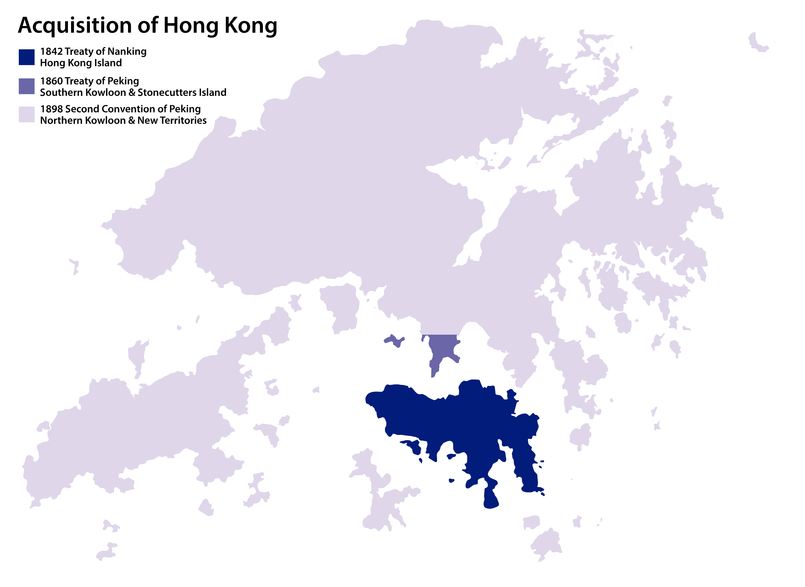
1. Hong Kong (if possible) is a British territory at this point
2. Aksai Chin and surrounding regions were claimed continuously by the Raj, Princely-State of Kashmir, and subsequently the Republic of India, but I've not seen much on whether this region was actually controlled or not. I like Kolchak's version since it includes some of the forts such as Khurnak Fort as part of the controlled region, but the area itself is very blurry. It is more than likely that this region is under Chinese control (or whatever authority is present in Tibet)
3. I've seen several sources for the Inner Mongolia borders with actual Chinese provinces, but you've got something slightly different, so could we see what you used for yours?
1. Hong Kong (if possible) is a British territory at this point
Already figured I should take a leaf out of Boris's book: I've made an inset for Hong Kong
I used Kolchak's earliest Q-BAM for 1911 Qing internals, the Inner Mongolia stuff she claims is from the "late Qing period"3. I've seen several sources for the Inner Mongolia borders ... could we see what you used for yours?
There was some administrative restructuring there during the late Qing period that isn't reflected in most maps. Basically the incorporation of territory into the provinces as part of a wider policy of settlement of traditional frontier territories.
Crazy Boris
Banned
I've decided to use the Qing Q-BAM internals provided by @Admiral A. Kolchak in her Warlord Atlas for 1884, masking @BonkeyDonk 's Tusi Map over the top, to these results:
View attachment 747139
I'm not super happy, especially with how Qinghai turned out, but I also have no idea what I'm doing when it comes to China, and I do not want to compromise on quality.
Literally any and all possible criticism is very much needed
I legit can’t thank you enough for this. I really needed a patch for Shanxi and Zhili’s Qing-era borders
Very nice work!I've decided to use the Qing Q-BAM internals provided by @Admiral A. Kolchak in her Warlord Atlas for 1884, masking @BonkeyDonk 's Tusi Map over the top, to these results:
View attachment 747139
I'm not super happy, especially with how Qinghai turned out, but I also have no idea what I'm doing when it comes to China, and I do not want to compromise on quality.
Literally any and all possible criticism is very much needed
This is supposed to be 1884? In October 1884, Xinjiang was created as a province, from its previous status as two separate frontier regions. So if this is the beginning of 1884, it would be split and probably should be in the darker territory colour.
As @Sharklord1 points out, Hong Kong should be there.
In this case, the "Late Qing period" is later than this map is set. For 1884, Inner Mongolia would look like this:View attachment 747173
Already figured I should take a leaf out of Boris's book: I've made an inset for Hong Kong
I used Kolchak's earliest Q-BAM for 1911 Qing internals, the Inner Mongolia stuff she claims is from the "late Qing period"
If this is 1911, aren't some of the northern provinces a bit exagerated, @Admiral A. Kolchak ? To my understanding, the northern provinces had exclaves and I've never seen Shengjing go that far north. For reference, these are maps I have:
Hmm, you may be very well be right. I'm mostly going off of woodhome's maps.If this is 1911, aren't some of the northern provinces a bit exagerated, @Admiral A. Kolchak ? To my understanding, the northern provinces had exclaves and I've never seen Shengjing go that far north. For reference, these are maps I have:
View attachment 747282View attachment 747283
Woodhome's map is definitely impressive, I still have their map of the Ming is my folder, but I think liucheng's is more accurate til further sources. Especially when it comes to inner MongoliaHmm, you may be very well be right. I'm mostly going off of woodhome's maps.
Last edited:
I'm inclined to agree, although regrettably it's somewhat less detailed.Woodhome's map is definitely impressive, I still have their map of the Ming is my folder, but I think liucheng's is more accurate til further sources. Especially when it comes to inner Mongolia
True, it is a lot less refined, maybe a merge of the two would work best, with liucheng's first level divisions, and then opting for woodhome's second and third?I'm inclined to agree, although regrettably it's somewhat less detailed.
Is there a comprehensive timeline to see when these administrative divisions were made? That'd be helpful in the future
Kolchak has the Warlord Atlas thread where she deposits maps of the Chinese warlord period.Is there a comprehensive timeline to see when these administrative divisions were made? That'd be helpful in the future
What site did you get these from?For reference, these are maps I have:
Share: