Fascinating maps, although the first’s a poor example of plans to divide Lebanon given that greater Lebanon’s extent (and thus if it would include the Litani) was very much in flux in 1919."Quite a few pre-1948 Zionist proposals, and a few British ones too, have a Jewish state that stretches all the way up to the Litani river in South Lebanon. These maps are also from Flapan’s The Birth of Israel."
You are using an out of date browser. It may not display this or other websites correctly.
You should upgrade or use an alternative browser.
You should upgrade or use an alternative browser.
Proposals and War Aims That Didn't Happen Map Thread
- Thread starter Beedok
- Start date
that image is not loading for meKarel Kramář's "Slavic Empire" plan

that image is not loading for me
It is though.
I wonder if you have the hosted URL blocked by a VPN or adblocker. You’re seeing the tail end of the text string, but you’re not seeing the beginning. Do you block all addresses from the CZ TLD? The beginning of the URL is like this:
cdn (dot) aukro (dot) cz/images/sk1613063827993/730x548/
I deactivated the adblocker and it still won't showI wonder if you have the hosted URL blocked by a VPN or adblocker. You’re seeing the tail end of the text string, but you’re not seeing the beginning. Do you block all addresses from the CZ TLD? The beginning of the URL is like this:
cdn (dot) aukro (dot) cz/images/sk1613063827993/730x548/
whatever, since it seems it's just me who has that issue, feel free to ignore it lol
the two halves of the empire being united by a single road is very funny nglKarel Kramář's "Slavic Empire" plan
I have the same issue.whatever, since it seems it's just me who has that issue, feel free to ignore it lol
We might be the silent majority..I deactivated the adblocker and it still won't show
whatever, since it seems it's just me who has that issue, feel free to ignore it lol
Shows fine for meWe might be the silent majority..
I love that tiny sliver connecting the Balkans to CzechoslovakiaKarel Kramář's "Slavic Empire" plan
It's called variously the Czech Corridor or Czechoslovak CorridorI love that tiny sliver connecting the Balkans to Czechoslovakia
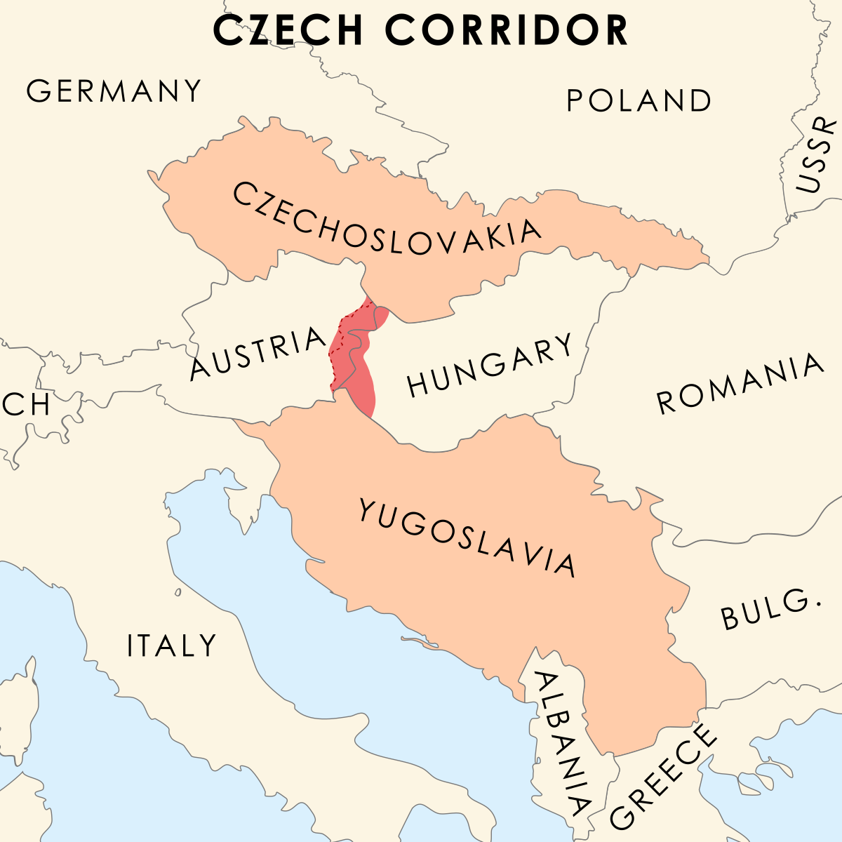
Czech Corridor - Wikipedia
I deactivated the adblocker and it still won't show
whatever, since it seems it's just me who has that issue, feel free to ignore it lol
Does this work?
View attachment 871219
Does this work?
Original one didn't work for me but this one does.
Also, tbh dobruja/Romanian coast would have been a much more natural method to achieve connection rather than the Czechoslovak Corridor.
I believe it was originally an idea dreamed up by pan slavists who wanted to unify Yougoslavia and Cezchoslovakia so it made more sense in that context. But I agree that in this union the Dobruja connection would make more sense.Also, tbh dobruja/Romanian coast would have been a much more natural method to achieve connection rather than the Czechoslovak Corridor.
I believe it was originally an idea dreamed up by pan slavists who wanted to unify Yougoslavia and Cezchoslovakia so it made more sense in that context. But I agree that in this union the Dobruja connection would make more sense.
Oh yeah, the corridor makes sense (at least as much as it can make sense) in context of Czechoslovakia and Yugoslavia.
But in the context of a full Panslavia Dobruja just seems more sensible (especially because it was at least Bulgarian at some points iirc unlike the pretty much wholly artificial corridor).
yesView attachment 871219
Does this work?
Works this timeView attachment 871219
Does this work?
Share: