Map Thread XV

Status
Not open for further replies.
Haha, Caesar? If I'm Caesar, you're Romulus. :p

I'll...pretend I know enough about Rome to get the reference :coldsweat:

Considering that Caesar is overrated, isn't that an insult from him? :p
Probably, yeah. My mapmaking skills aren't exactly deserving of compliments, haha. :p

No insult at all; I just used a turn of phrase I'd heard.

Just wow.

One of the better maps I've seen on here so far this year, keep up the fantastic work! You really inspire me to work harder :)
Holy crap this is the best map I've seen in a while!

All I have to say is: dang.

Thanks for all your praise/comments! I'm faintly overwhelmed and humbled and a half dozen other wonderful things.

Amazing work! It copies the style of actual maps well. It looks like an actual artifact from an alternate timeline.
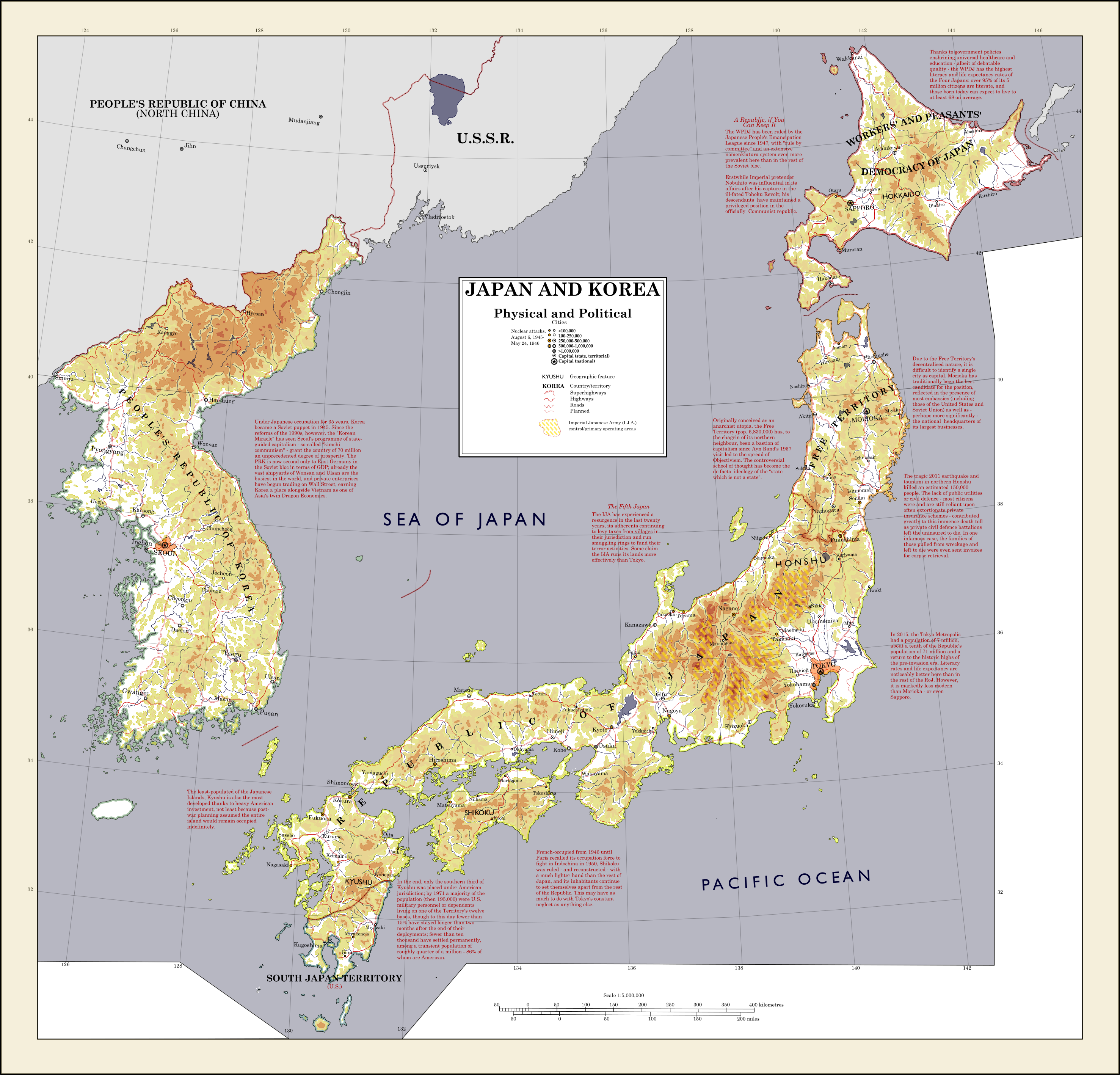
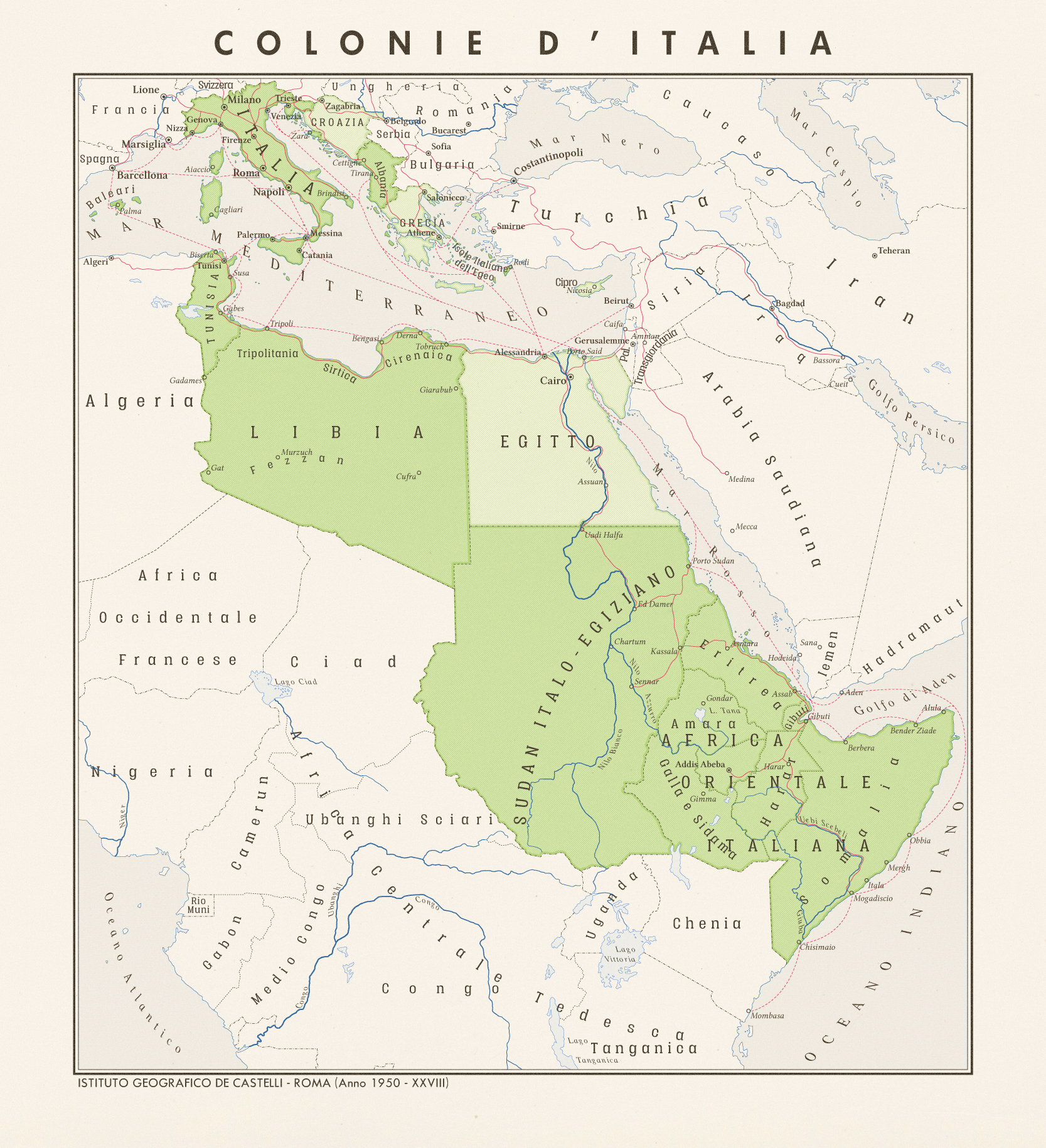
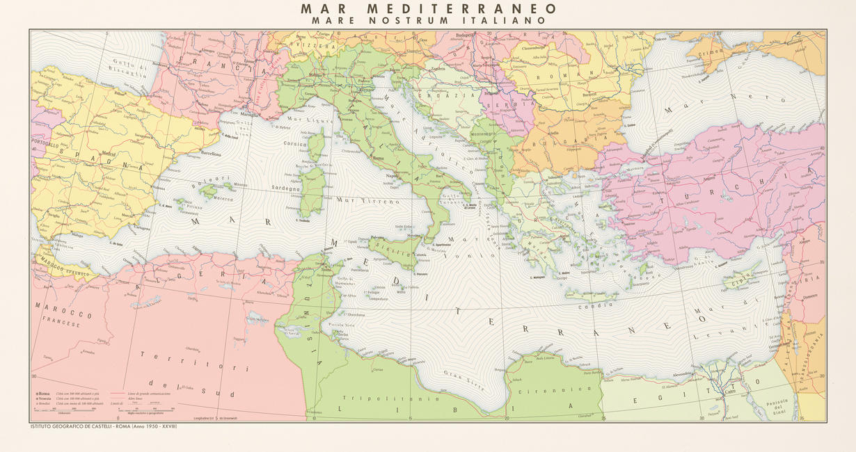
I love the red text annotations, really gives it the look of an existing map that has had notes added to it.

Cheers to you both; I was inspired by Nat Geo maps I've seen, and it seemed an effective way of "show, not tell".
 

Isaac Beach

Banned
Something which has occupied far, far too much of my time recently (yet also somehow not enough): a big damn map of Japan and Korea for @The Red 's TL Decisive Darkness. He didn't ask for it, didn't particularly need it, so by cracky I went over the top!

decisive_darkness__2017_by_bolshiekiwi-db2ccsn.png

Utterly phenomenal. It'd look better in a geopolitical textbook than on here.
 
italian_empire_after_axis_victory_in_ww2___part_1_by_1blomma-db2dzq6.jpg


italian_empire_after_axis_victory_in_ww2___part_2_by_1blomma-db2e02v.jpg


Italy and her empire after a successful campaign in World War 2. Dark green is directly controlled by Italy, light green are satellite states. Croatia is tied to Italy through their king being an Italian prince, and the same thing goes for Greece. Most of the Mediterranean islands are controlled directly or indirectly by Italy, thus fulfilling Mussolinis dream of his new Roman Empire. In France, only Nice, Corsica and a small strip of land on the border was annexed to Italy, with all the land up to the Rhône being under Italian occupation.

Why not take the boat from Rome to Tripoli and then board the train across the historical battlefield of the Western Desert to Cairo, then turn down along the Nile to Addis Abeba and Mogadishu where you can enjoy a sunny vacation?

Link to an enlarged version of the Mediterranean map, since the forum doesn't want to show it in full
 
Which one of these crude set-ups do you guys and gals prefer visually?

(Yes I am aware that the quality is bad, but the original map is far to large to upload, so I just took a picture with my crummy phone.)

BrSe32z.jpg
 
Quick little doodle of various definitions of Europe. The lightest shade is the European Peninsula proper, the middle shade is other parts of geographical Europe (Scandinavia, the British Isles, the rest of Russia west of the Urals), and the darkest shade is territory that is not geographically European, but which has political ties (Iceland, Greenland, Asian Russia, Anatolia, Cyprus, the Iberian Atlantic, and the Transcaucasus).

View attachment 312096

The Scandinavian category should extend slightly further down in the Caucasus, but otherwise, great job!
 
Quick little doodle of various definitions of Europe. The lightest shade is the European Peninsula proper, the middle shade is other parts of geographical Europe (Scandinavia, the British Isles, the rest of Russia west of the Urals), and the darkest shade is territory that is not geographically European, but which has political ties (Iceland, Greenland, Asian Russia, Anatolia, Cyprus, the Iberian Atlantic, and the Transcaucasus).

View attachment 312096

Points for putting Scandinavia on the same level as the British Isles - it's easily forgotten but we do not think of ourselves as part of "the European continent", and many people speak of "going to Europe" when going south of Denmark.
 
Italy and her empire after a successful campaign in World War 2. Dark green is directly controlled by Italy, light green are satellite states. Croatia is tied to Italy through their king being an Italian prince, and the same thing goes for Greece. Most of the Mediterranean islands are controlled directly or indirectly by Italy, thus fulfilling Mussolinis dream of his new Roman Empire. In France, only Nice, Corsica and a small strip of land on the border was annexed to Italy, with all the land up to the Rhône being under Italian occupation.

Why not take the boat from Rome to Tripoli and then board the train across the historical battlefield of the Western Desert to Cairo, then turn down along the Nile to Addis Abeba and Mogadishu where you can enjoy a sunny vacation?

Link to an enlarged version of the Mediterranean map, since the forum doesn't want to show it in full

I need to learn how to make maps this great.
 
Bonaparte-4.png

What do you know, another Bonaparte-4 cover WIP. I swear, this is becoming almost routine for me. Although this time there isn't anything I'm very unsatisfied with (so far).

As usual, I welcome and appreciate questions, comments, criticisms, suggestions, and any other feedback.
 

Faeelin

Banned
View attachment 312186
What do you know, another Bonaparte-4 cover WIP. I swear, this is becoming almost routine for me. Although this time there isn't anything I'm very unsatisfied with (so far).

As usual, I welcome and appreciate questions, comments, criticisms, suggestions, and any other feedback.
interesting that the US got British red. I like it, and think this is the realistic take on "French Louisiana" in the TL.
 
Hey guys, are there any existing maps of either US States fit into Russia borders or of Russian federal subjects fit into US borders?
Also did I explain what I mean in a coherent and understandable way? If not I will edit.
 
Which one of these crude set-ups do you guys and gals prefer visually?

(Yes I am aware that the quality is bad, but the original map is far to large to upload, so I just took a picture with my crummy phone.)

maps
I kinda like the bad quality. Reminds me of the slide shows we'd get in grade school in the early '80s.
 

Deleted member 94708

Something which has occupied far, far too much of my time recently (yet also somehow not enough): a big damn map of Japan and Korea for @The Red 's TL Decisive Darkness. He didn't ask for it, didn't particularly need it, so by cracky I went over the top!

That is one SERIOUSLY broken Japan... and a truly excellent map.
 
Top
Status
Not open for further replies.
Top