Collaborative timeline: Dunes of the Desert, a Timeline without Islam

Interlude VIII: The Structure of the Miaphysite Communion
RelMya.png

The Miaphysite Communion is a communion of national churches which recognize the Coptic Pope as primus inter pares.
  1. Coptic Orthodox Church based in Kashromi (due to Alexandria/Rakote being under Rhomaic administration). The church extends into Nubia and Cyrenaica.
    1. Abunate of Axum (to cover Ethiopia)
  2. Syriac Orthodox Church based in Damascus.Extends across the Levant
    1. Maphrianate of the East, based in Tagrit, to cover Mesopotamia and Persia
    2. Maphrianate of Himyar, based in Zafar, to cover Himyar and Arabia
  3. Armenian Apostolic Church based in Echmiadzin.
    1. Church of Aghbania, based in Partav, to cover Aghbania and Khazaria
 
Interlude XI: Trade
upload_2019-8-5_15-22-26.png

So here above we have sketch of the major trade routes. Red are overland routes, blue are maritime routes, light blue are river routes. In general, the trade routes have not shifted significantly from this map https://www.visualcapitalist.com/medieval-trade-route-map/, although there are some changes:
  1. There is less traffic in Arabia. The hajj routes do not bring pilgrims to Mecca, and therefore, the roads just dont all lead over there.
  2. More India trade. Contact between Gulf of Aden, Straits of Hormuz and India remains strong.
  3. More contact across the Mediterranean. Carthage has come to dominate the Western Mediterranena Trade, rivalled only by Pisa and Marseille
  4. Regular contact between Syracuse (Sicily) and Alexandria

This is last interlude before the next chapters. Looking forward to hearing your suggestions for the 11th century.
Also, should you wish to contribute, you are welcome to do so and write your update (before that I kindly remind you to take a look at the previous updates over the region in the threadmarks)
 
Last edited:
Chapter 57: Zhongguo: Song, Lia and Xin and the Eastern Steppe
Let us begin by taking a look at China. China itself has not yet been covered, although one of the previous updates spoke of the Khitan Liao realm of northern China.
upload_2019-8-7_15-5-24.png

A political map of the area discussed

China during the 11th century is ruled by the Song dynasty, and consist mostly of the regions between the Yellow River and the South China Sea.

Song China would indeed be quite sophisticated and socially complex. The cities of Kaifeng and Hangzhou would have more than a million inhabitants each. Social welfare programmes, such as retirement homes and public clinics would have been established.

The core of China has shifted southwards during this time. This is caused, well, by the fact that the north was occupied by the Liao, but not only because of that. The population growth in the south was much faster than in the north. Especially the region of Fujian (1) experienced a dramatic population growth. The coastal regions would prosper due to maritime trade and shipbuilding industry. Maritime trade and contact would be maintained mainly with the realms of Indochina, such as Khmer, Champa, Srivijaya, with the Indian Subcontinent and even the Middle East. Contact was even present with the East African Coast, while of course natural contact was also with Korea and Japan.

Southern China would be also hit by intense deforestation: not only to provide for more living space for the south´s rapidly growing population, but also to burn charcoal in the furnaces to smelt iron. While the iron industry was very widespread as were the deposits of iron ore, precious metals were not. Therefore, Song China would be the first in the world to issue paper money.

The state administration during this period would also change quite dramatically. While the Tang China would be a quasi-feudal society, relying on aristocracy, the society of Song China would move away from this model and go for the bureaucratic administration. Indeed the Chinese civil service and the meritocratic model would become associated to China. Bureaucrats would educated in schools and pass imperial exams – this would be a tool for upward social mobility (should you be lucky enough to go to school).The postal service would provide communication throughout the vast empire of China. Postal offices were also integral parts of the Chinese civil service. The country would be held together by a system of roads, and many new bridges were built during this period
upload_2019-8-7_15-9-43.png

Religions of China and the Steppes
Foreign religions in China have been purged to great extent by the Great Anti-Buddhist Persecution, under the later Tang dynasty. The foundation of monasteries had become a major social issue, as many people would retreat to monasteries and classical family bonds would be broken. Furthermore, the monks themselves would not be active neither in agriculture nor in other forms of economic activity. Rather, monasteries would function at the expenses of the others.

The main target were Buddhist monasteries, yet other religions viewed as foreign would be targeted as well – be they Nestorian Christians, Manicheans or Zoroastrians (2). However, presence of these minorities would continue – especially the city Guangzhou (3) would host a significant Christian community, practically dominating the commerce.

Manichaeism in the lands of the Song dynasty would be suppressed; nevertheless, Manicheans manage to cling on to their faith secretly in the southeast of the country.

The Buddhist Tangut realm of Xi-Xia continues to dominate the Hexi corridor. Vajrayana Buddhism would be the major religion in this realm. A Nestorian archbishopric would be present in the area, and it would become known to Nestorian monks as Beth Tuptaye (meaning House/Land of Tibetans)
800px-Liao_circuits.png

Administrative divisions of the Liao
The Liao dynasty would continue to dominate northern China, Outer Mongolia, Inner Mongolia, Outer and inner Manchuria as well as northern Korea. As mentioned previously, the governing a realm half nomadic and half sedentary is practically very difficult, and the Liao divided the area into a northern and southern administration. This hoped to solve the problem, however this administrative model would be further elaborated, with the southern region being divided into four.

The eastern region (Dongjing) would consist of parts of Inner Manchuria and northern Korea. Previously, this area was part of the old kingdom of Balhae.

The central region (Zhongjing) had previously been inhabited by the Hsi, a Mongolic people. The Liao intended to build here a major city, as the climate was very temperate: however, only a few Chinese colonists arrived.

The southern region based around Nanjing (4) was heavily taxed. Rice fields were banned, as the canals were deemed to make Liao cavalry ineffective.

The western region (Xijing) had no features of note, except being populated by ethnic Chinese. The bureaucrats in the south would be mainly ethnic Chinese. They would have a large freedom in decision-making; however they would be deprived of control over the military.

The geographically largest portion of the country was administered from Shangjing and belonged to the northern region. These areas would be populated mostly by nomadic, Khitan and Mongolic peoples, and thus could be administered in the traditional nomadic way. However, there would be still a considerable sedentary population, which would also be governed in a southerly way.
Gurvger.jpg

Yurts were the basic housing of the Steppe dwellers
Among the tribes of the north were also the Keraites. The Keraites living in south-central Outer Mongolia would convert to Nestorian Chrisitianity (according to the legend one of their khans got lost in the snowy winter mountains, and then he had a vision of Saint Sergius). Who knows, how it really was. However on all accounts, the khan would seek Nestorian merchants. They would pass the knowledge of Abwun d´Bwashmayo (5), Lakhu Mara (6) and Qadisha Alaha (7). The khan would be baptized at Navekath (8). The Keraites later petition the Patriarch of Qtespon, whether they could be exempt from the usual way of fasting, for their diet consists mostly of milk and meat.

The reply from Mesopotamia stated that they were allowed to drink milk; however, meat-eating during the Lent would be forbidden. Furthermore, they ought to search for wine and wheat sources to allow Eucharist celebration.

The conversion to Chrisitendom would be followed also by other Mongolic clans, most importantly the Naimans, living on the eastern slopes of the Altai mountains, and the Onguts at the Yellow River bend.

A diocese would be established for the “Lands of Naimans, Keraits and Onguts”,

Outside of Liao rule, the Khamag Mongols, the Merkits, the Buryats and the Tatars would continue to rule their small khanates, as well as the Kyrgyzes, a Siberian Turkic people based around the upper Yenisei basin.

Due to Mongolic clan dynamics, the Buryat tribe takes over the northwestern shores of Lake Baikal, the ancestral lands of the Kurykans. The Kurykans are thus expelled and move downstream the river Lena, arriving in Yakutia (9).
1024px-120_%D0%9D%D0%B0_%D1%81%D1%82%D0%BE%D1%8F%D0%BD%D0%BA%D0%B5_%D0%B2_%D1%83%D1%81%D1%82%D1%8C%D0%B5_%D1%80%D0%B5%D0%BA%D0%B8_%D0%A3%D1%80%D0%B0.jpg

A view of the Yakut´s new home
The vast expanses of the northeasternmost extensions of Asia appear to be populated by Evens and Lamuts, Tungusic peoples in the central regions, and more ancient populations of Kamchatkan, Yukaghiric and Yeniseian (Ket) tribes. Each new wave of incomers from the south appears to have had a technological advantage over the previous tribes. Therefore, the Tungusic peoples had displaced the original Yukaghiric and Yeniseian peoples; and the Sakha took over Tungusic tribes on the Middle Lena.


(1) The area opposite Taiwan

(2) Zoroastrian diaspora in China would be less numerous due to no Islamic conquest of Iran; it would rather consist more of merchants and commoners, than major noble families and the elite.

(3) Canton. Historically Muslim. Here, I´m presuming that this role would be taken over by Nestorians.

(4) The contemprorary name for Beijing. Beijing means northern capital; for the Liao, however, it has at the southern borders

(5) Lord’s Prayer

(6) Te Deum

(7) Trisagion

(8) Navekath, Kyrgyzstan. Historically, Merv. Here, the Church of the ast is more widespread, without islam.

(9) Yes this happened.
 
What religion is being followed if not Buddhism? Is it Confucianism, Taoism or is any "native" Chinese religion accepted? As always your maps are great and your texts very detailed although I do wonder why you write so many sentences as subjunctive "would"-clauses.
 
What religion is being followed if not Buddhism? Is it Confucianism, Taoism or is any "native" Chinese religion accepted? As always your maps are great and your texts very detailed although I do wonder why you write so many sentences as subjunctive "would"-clauses.
The religion followed appears to be what EU4 and Chronas depict as "Confucian"; apparently a mix of Confucianism, Taoism and Chinese Folk Religion.

Well thanx for the compliment. I am shifting from CK2 to URHAFAH as basemap, due to both accuracy and greater detail, as well as butterflies appearing in places off the scope of CK2. The map shall be updated as more regions get updated.

While writing, I did not actually consciously employ this subjenctive mood: however those "would", "appear" and other uncertain words are a result of the fact that I knew little about the facts mentioned and as a result it is my sort of reading comprehension from Wikipedia, meaning I am rather unsure of the facts stated.

These events or descriptions are not a direct result of the non-Islam event, but rather a general setting .
 
Chapter 58: Rice, Elephants and Spice
To the south of China is a large peninsula, known to the western observers as Indochina or Farther India. Indeed, this latter expression is not complete nonsense and is actually closer to the description of reality than the former. The peninsular region between the Bay of Bengal and the South China Sea, together with the Spice Islands, also known as Islands of the Sea, would be greatly influenced by the culture of the Indian Subcontinent. This would, of course, be caused by geography.

Contact with China on the overland route would be largely blocked by the mountain jungles, a region later described by scholars as Zomia, with a sole opening along the coast of Vietnam. Chinese influence in Vietnam was also strengthened by the existence of a cold water current running southwards along the coast of the South China Sea.

Similarly, overland influence from India would be blocked by the Arakanese Mountains, blocking contact between the basins of the Brahmaputra and the Iravadi. The peoples on the western coast of the Bay of Bengal have however taken advantage of the warm ocean currents connecting the Tamil realms of India and Ceylon to the Iravadi Delta and the straits of Malacca. From there, merchants, goods and ideas could travel with ease northwards to the Khmer lands. Under the term ideas, we ought to understand the spread of first Hinduism and later Theravada Buddhism originally from Ceylon, into Southeast Asia.

While ideas would spread via the sea, people arrived and continued to arrive into the region taking a north-south direction. The major rivers- the Iravadi, the Salwin and the Mekong all flow in a north-south direction, with their sources in the eastern parts of the Tibetan Plateau. Those living further upstream, be they of the Tibeto-Burman or the Tai-Kadai stock, and have been migrating downstream, from the narrow upper valleys to more open lowlands further downstream.

The topographic variety of the region has also expressed itself in a rather unique phenomenon in comparison to other parts of the world. The lowlands and valleys would be home to sophisticated societies, while at the same time their kinsmen – people speaking very much the same tongue as the lowlanders, but living in the highlands and voluntarily rejecting the costs and benefits of state-organized societies, would live right next them and be viewed as a living echo of the past.

Another rather unique phenomenon in the region is the existence of the mandala system. Rather than the standard notion of political unit with a defined boundary, the Mandala system of states views them as concentric circles, defined by their capital, with a sphere of influence encompassing tributary states. Control over the nearer city-states is more intensive than over the ones further away Moreover, a city-state can belong to two larger units simultaneously.
upload_2019-8-8_20-31-31.png

Forms of government of Southeast Asia. Orange-red is the Mandala system; yellow orange are plutocratic monarchies, brown is tribal, green bureaucracy and the blue over there represents "monarchy without any major attiribute".

But let as take a look at the polities of the region. On the shores of the Tonkin Bay, we have Dai Viet. The land is ruled by the Lý dynasty, and has frequent contact with Song China, Champa, Khmer and Java. Relations with China also culminated in warfare.

Dai Viet during this period had been greatly influenced by neighbouring China. Although the ruling Lý dynasty were devout Mahayana Buddhists, the influence of Chinese Confucianism resulted also in the spread of the bureaucratic civil service system, with examinations of the future civil servants. The country transits from an autocratic society to a rule of law.

Further southwards, between Dai Viet and the Mekong Delta, we have the Champa kingdoms. The Chams are a people belonging to the Malayo-Polynesian that is Austronesian language family. It is presumed that the Chams arrived to the region as colonists from Borneo. They have preserved their seafaring traditions and were involved greatly in maritime commerce. Particularly the coastal city of Thi Nai, trading with Guangzhou, the Philippines, Borneo and Sumatra can be viewed as a major trade node in the entire South China Sea. Champa ought however not to be regarded as a unitary polity. No, it was rather a collection of numerous city-states, with most of their settlements located along the coast. The predominant religion of the Chams is Hinduism, although there had been a period (9th-10th century), when Buddhism was imposed by the Indravira dynasty. Mazdakism would arrive to the lands of Champa in the form of Mazouni trade emporia.

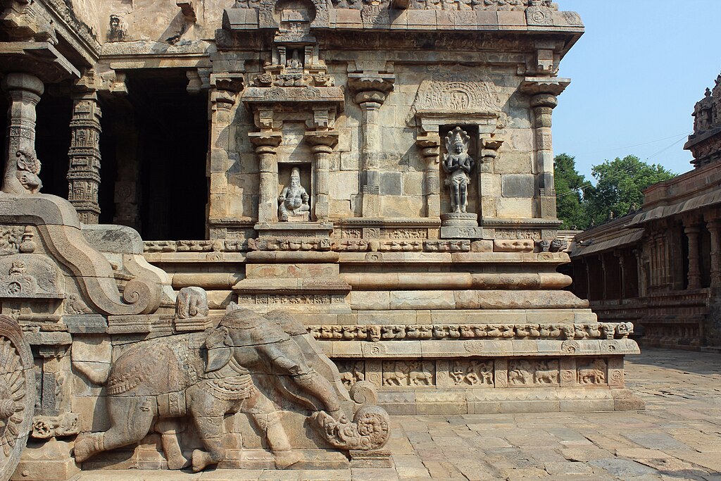
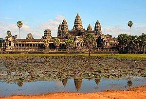
Further westwards we can observe the Khmer Empire. The Khmers have built a remarkable empire, spanning from the Mekong Delta, across the Tonle Sap to the Gulf of Siam.
300px-Angkor_Wat.jpg

Angkor Wat, pride and jewel of the Khmer Empire
During the 10th century, the Khmers allied themselves with the Cholas of southern India in war against Srivijaya on the Sumatra. The Khmers at this time are still Hindus.

Khmer economy is built mainly on rice growing, but also on palms grown for sugar, wine etc. Women enjoyed an important role in commerce. They would marry young – this appears to explain the fast population growth.

The country would very well qualify as a hydraulic empire – the royal administration would take care of canal building and irrigation projects. A local version of the caste system was established, with the monarch at the very top, acting like a God-King, or Devaraja.

Further southwards was the extension of the Malay Peninsula, known as the Golden Khersonese in the antiquity. Separated by the Malacca Strait from Sumatra, these two areas would be ruled together as part of the Srivijaya Empire. Srivijaya was a dominant thalassocratic empire dominating a large part of maritime Southeast Asia, mainly Sumatra, Malay Peninsula and western Borneo.

In the early 11th century, however, Srivijaya was invaded by the Chola Empire, based in Tamil Nadu, which is in south-eastern India. The immediate result of the campaign was a weakening of Srivijayan naval hegemony, allowing the formation of smaller regional kingdoms such as Kediri not based solely on long-distance trade, but rather on agriculture. Even in the maritime southeast Asia one can witness the Mandala model of governance, especially when observing the Srivijaya Empire. The word “Empire” may not be a very precise word – it was perhaps a confederation, similar to the maritime league of Athens at the time of the Peloponnesian war.
800px-Srivijaya_Empire.svg.png

Srivijayan Empire at its height
The predominant faith of Srivijaya would be Tantric (Vajrayana) Buddhism. The northwestern tip of Sumatra has begun witnessing the arrival of Mazdaki merchants from Mazoun (1)

The island of Java was home to two major realms: Sunda on the west and Kediri in the east. Further eastwards was the realm of Bali. Despite the arrival of Buddhism further west, Java and Bali remain staunchly Hindu.

Further northwards we have the island of Borneo. Its western coast being ruled by Srivijaya, its northern coast forming another mandala around Brunei and ultimately the kingdom of Kutai on the eastern coast. The inlands remain mostly unexplored rainforest; Brunei and Kutai Hindu mandala states.

The Greater Moluccas, known to quite a few of our readers as the Philippines had also some emerging states during this time period. The kingdom of Tondo based in the region of southern Luzon and Butuan on northeastern Maguindanao. These realms appear to be in regular contact with the Champas and the Song dynasty. Butuan was greatly influenced by Srivijaya, and Hindu influences were rather strong.

The Mon Buddhist realm of Harapunchai manages to preserve its independence in the Highlands of what could later become Thailand; and the Mon people continue to inhabit the Iravadi Delta and the coastal regions southwards. The Mon are credited for the transmission of Buddhism into the region; it is thought that Buddhism arrived into the region via the coastal town of Thaton. The Mons are seen as the predecessors of later cultures who would come inhabit Burma. It was speculated that the Burman script was based upon the Mon script; other suggest that it was based upon the script used by the Pyu states.

The Iravadi valley would come to be ruled by the state of Bagan, sometimes spelt as Pagan. Its inhabitants, despite the name, would not be pagans. The gross majority of them would in fact be Buddhists. Theravada Buddhism would be taken from the conquered Mon and imposed over the population of the Upper Burma, where it would displace Vajrayana Buddhism and local forms of animism.
800px-Bagan%2C_Burma.jpg

Bagan: the city of a thousand pagodas
The ruling class spoke Old Burman; however the majority of their subjects would continue to speak Pyu, another earlier Tibeto-Burman language in the Upper Iravadi Valley; the lower Iravadi basin would continue to speak Mon. Pali would come to be used as well as a liturgical language of the Theravada.

The coastal areas west of the Iravadi valley, known as Arakan, were connected greatly towards India, especially the Pala; as a result the Arakanese coast would be mostly Mahayana Buddhist.

The Thaic speakers of the Shan language were settled in the Shan plateau; they were mostly tribal, occasionally subdued by the rulers of Bagan. The Thaic peoples were gradually moving southwards from southern China into the Indochinese Peninsula.

The Dali kingdom, found in the jungles of Yunnan was a Tibeto-Burman Buddhist kingdom, on amicable terms with the Song. Its main ethnicity were the Bai, but within the realm there was a considerable number of Zhuang, or Taic peoples. Those would retain their own beliefs; the Bai have adopted Vajrayana Buddhism for the most part, though.

The city of Dali itself was an important trade centre at the end of the Hose Tea Road, connecting the upper Brahmaputra Valley through Chamdo to Dali and eventually through the mountain passes into the Iravadi Basin.
upload_2019-8-8_20-37-40.png

My understanding of the linguistic situation of the region at 1100AD

(1) Analogous to the arrival of islam OTL.
 
It's an interesting world. Don't make too many parallelisms for the future. Keep it open.
Some parallel events are derived from geography. Like trade routes or ocean currents. I do agree, however that not all Muslims, once Nestorian or Manicheism will act very much the same way :). Taking a look at Northern Africa, Arabia and Egypt, shows us that this timeline is not that parallel, however. Actually I disregarded OTL developments altogether over there
 
I just speed-read this entire timeline and its really interesting and cool. You put in so much detail and have covered such a large time period, not to mention your prolific use of maps which IMO makes it way easier to visualize the world. Some areas I am interested to see how they turn out:

Iran: Sooner or later as history has mostly shown, one power will come to dominate the whole area. I'm surprised this hasn't happened yet and whether it will be christian or Zoroastrian. I assume the state that has western Iran and southern Mesopotamia will win out. This will inevitably lead to roman consolidation of eastern anatolia and syria and the whole rivalry will start again?

Spain: In OTL the reconquista did a lot of damage to the peninsula. IRRC the land was wasted by the production of merino wool and a region once a breadbasket became agriculturally poor. That was why Spain had a very low comparative population until 20th century OTL. In 1850 Spain had a lower population than Ireland at 7.5 million to 8 million. Also without constant war they can focus on trade earlier maybe leading to earlier voyages of exploration?

France: Will the normans arrive as in OTL and if so will they conquer britain? Also has Neustria attempted to conquer Occitania because in OTL that area due to geography was alway dominated by power around Ile de france. Maybe Hispania is guarenteeing Occitania?
 
Chapter 59: Establishment of Manicheism in India
Let´s take a look at the Indian Subcontinent, shall we? In the south we have the Buddhist kingdom of Ceylon ruled by the Lambakannas. Further north the Chola Empire is the dominant power of southeastern India, dominating the trade over the Bay of Bengal. The staunchly Hindu kingdom of the Cholas is the dominant bastion of Hindu revival in the south of the Subcontinent. The Cholas rule also over Hoysala, Andhra and smaller realms along the Malabar Coast. The entire Keralan coast by now is populated by St. Thomas Christians, a local Christian community dating their origins very early, since the time of the apostles. In terms of jurisdiction, they belong to the Church of the East, as the Metropolitan province of Beth Hinday, with the Metropolitan seated at Cranganore.
1024px-Airavateswara_Temple%2C_Darasuram_in_Thanjavur_District.jpg

Airavateswara Temple: an exmaple of Chola architecture
The western Deccan plateau is still dominated by the Chalukyas. The Chalukyan dynasty are not that staunch Hindus, and have been patronizing all religions within their realm. They themselves appear to be very sympathetic to Jainism, which is still prevalent in the region; Buddhism has greatly declined in the region, to such extent that it cannot be seen on the map of the religions any more.

The northeastern Deccan plateau has always been described as more barbarous than other parts of the Subcontinent. These regions are still home not only to northern Dravidian peoples, but also to earlier Munda peoples speaking Austroasiatic languages (similar to those spoken by the Khmer). These peoples are collectively known as the Adivasi, and have been living in tribal societies outside the caste system.

The peoples of this area known as Gondwana, after the predominant Dravidian people of Gondi, would not practice Hinduism. Rather, their religion was Sarnaism, a very ancient religious tradition, whose places of cult were placed in hallowed groves.

The combined region of the Ganga and Brahmaputra Deltas was ruled by the Pala Empire. The Palas remained major patrons of Mahayana Buddhism. While Buddhism has been declining in almost every other part of the Subcontinent, in the Pala Empire, it prevailed. This was caused also by its urban nature: the regions further south were mostly rurally based, and Buddhism was very much connected to the urban civilization of the Gangetic plain.

Buddhism was also in decline in the lands of the neighbouring Gahadavala dynasty, controlling the Middle Ganges River. Its rulers, while mildly sympathetic towards Buddhism, would prefer Hinduism instead.

Northwestern India, places like Gujarat, Avanti and Rajputana also witness the predominance of Hinduism. Any remaining Buddhist communities are squeezed under the foot of the Himalaya Mountains. Jainism is also retreating southwards.
upload_2019-8-9_21-53-10.png

Trade routes in India. Source: A Fascinating Map of Medieval Trade Routes (note: all other images are mostly wikipedia, maps are mine)

The coastal regions of Gujarat were involved intensive westward trading. Particularly important were the ports of Diu, Cambay, Baruch and Tanah. Mazouni merchants were in frequent contact with this region; ultimately the cosmopolitan nature of the area resulted in a rather widespread conversion of some coastal communities to Mazdakism (1).

Further northwards we arrive into the region of Sindh. The area based along the Indus Delta had been exposed to frequent contact with Mazoun. Previous centres of Mazdakism have expanded substantially, as had the Nestorian community a little further south.

As for the Indus valley, it has been severely hit by the conquests of Zaku of Jaguda. Zaku of Jaguda was ruling in regions of Zabulistan and Kabulistan,that is on the eastern fringes of the Iranian Plateau. He was a devout Manichean and was prepared to invade the Indian Subcontinent. He did dedicate quite a lot of time to see where Alexander the Great has failed and prepared not to make the same errors. The traditions surrounding Alexander the Great in the region of Zabulistan and Kabulistan were very strong, and he was viewed as a very positive figure. The name "Sicandar" would be used not as a name, but rather as a title, similar to that of Caesar in the west.

Crossing the Khyber Pass into Peshawar, Zaku´s Turkic armies had followed the footsteps of many before them. The Shahi dynasty, originating in Kabul, was easily defeated by Zaku, allowing him to seized Peshawar and Multan.

Zaku of Jaguda managed to crush most of his enemies in northwestern India. Many cities were sacked, and the loot was taken to Jaguda. The worth of the loot was difficult to enumerate. Many especially Hindu and Jain temples were looted; Buddhist not so much. The treasures were concentrated in Jaguda, which would attract many scholars and poets. New colleges, caravan hotels and gardens were founded in the heart of the realm.

The western and northwestern parts of the Jagudid realm were lost to the Seljuqs, forcing the Jagudids to concentrate more on India. The effective border would be the (almost) impassable Hindu Kush. Many Manicheans from the Bavandid realm, now overrun by the Seljuks , would arrive in the Jagudid realm.

The Jagudids themselves had by this time thrown away any Turkic cultural traits, and greatly adopted Persianate culture. The heirs of Zaku of Jaguda would not focus that much upon conquests, but rather would seek to bring the word of Mani to the Subcontinent. Manichean clerics could build upon the pre-existing Buddhist traditions of Gandhara and Multan. Buddhism as mentioned was in decline in India at this time, as it had become detatched from the people.
upload_2019-8-9_21-37-26.png

Manicheanism has established itself in the Indus Valley
The conquerors sought to take advantage of this situation, use the already existing layer of Buddhist traditions, and present Manicheism as something new. These policies resulted in an even faster decline of Buddhism in Gandhara and Punjab; meanwhile Hindu temples were very often targeted and destroyed or sacked, be they in or outside of his realm (2).

Ultimately, the Helmand Valley, Kabulistan and Multan had become Manichean with a few generations. Buddhism continues to survive in the region in the less accessible mountainous regions. The region of Makran to the south of Zabulistan manages to remain a backwater; local Zuni beliefs are intertwined with Buddhism and Zoroastrianism to a greater part; the southern coastal areas around Gwadar, under Mazouni influence, have converted to Mazdakism.

Local tradition in Kashmir had it that Jesus had visited India in prior to his ministry, where he ought to have been instructed by Buddhist monks. Hints were found by critical later scholars, who found that Christian “innovations” to the Old Testament were very similar to Buddhism. While Manichean clerics did not comment much on the issue whether He visited Kashmir or not, this tradition also aided them in converting the people of the region. After all, the messages of Buddha, Zoroaster and Jesus were from the same source, remember (4).

Beyond the Himalayas, there is the Tibetan Plateau. It has been described by some as the Roof of the World, located beyond the Himalayas, bordered on its north by the Kun-Lun Mountains, separating it from the Tarim Basin. Interestingly enough, the Himalaya Mountains, the highest mountains of the world had been more often passed than the lower mountain ranges of the Tibetan Plateau.

This can be explained, that heir northern slopes descend again into the upper Brahmaputra and Indus valleys, which are home to major centres of Tibetan civilization, such as Lhasa or Leh. Indee, the two upper river valley had become two major cores of Tibetan culture: Guge and Ladakh on the Upper Indus, while Lhasa on the Brahmaputra.
Aba_County_Aba_Prefecture_Sichuan_China.jpg

A Tibetan Stupa at Ngawa, Tibet
The plateau had formerly been united by the Tibetan Empire until the 9th century. The 10th and 11th centuries are subsequently known in Tibetan historiography as the period of fragmentation. The 11th century is known as the Tibetan Renaissance, which I know nothing about, am too lazy to do research, and anyway it happened the same way as it did, didn´t it?

(1) The nature of the Mazdaki religion by this period has severely changed. More information about it will come when we start discussing Mazoun.

(2) Indeed, the Jagudids did have a Manichean worldview J

(3) There is an alleged tomb of Jesus at Rozabal, Srinagar, Kashmir

(4) Mani claims that Zoroaster, Buddha and Jesus all received the true message, which was summarized by him, of course. It reminds me Muhammad claiming succession to the Prophets and Jesus…
 
Last edited:
Alright folks so I am departing to go on a camping for two weeks, see you later. Feel free to add stuff about Europe or the Mediterranean (I already have some ideas for Greater Iran and the sogdian steppe myself).
Adding here my new maps so you can contribute:
Political:
upload_2019-8-9_21-50-33.png

Governments:
upload_2019-8-9_21-51-4.png

Linguistic:
upload_2019-8-9_21-51-39.png

Religions:
upload_2019-8-9_21-52-8.png
@Chickennuggetscientist:
  1. Iran: Nestorian Seljuks are just brushing their swords to do the job. Maybe a Carolingian arrangement with the Patriarch of Qtēspōn comes in mind.
  2. Spain. Europe is entering the period where the defensive again regains advantage over the offensive. This leads to feudal fragmentation throughout Europe. For some reason I found out that if your country existed in 1000AD it will be there in 2000AD as well. Anyhow, Spains not going to be an exception. The taifas provide a good excuse for this as well. In my latest Spanish update I have sketched that urban Betica and feudal Meseta are greatly diverging
  3. France. No idea whatsoever. Perhaps Occitania will be split between a state based at Bordeu and one at Tolosa. Who knows. But the notion of La langue neustrienne sounds cool to me :)
 
Last edited:
I'm just wondering, what script are the persians using?
Apparently it did use Pahlavi script. Avestan could be used for Zoroastrian religious purposes.
Manichean communities would use Manichean script (claimed to be devised by Mani himself).

Is there a script map scheme somewhere? I have been thinking of mapping the use of alphabets as well
 
Chapter 60: Nomad, Speak Turkic
So folks I am back, so let us take a look at Central Asia, shall we?
upload_2019-8-24_18-5-11.png

A political of the area discussed: Cumania (orange), Bolgharia (green), Baskhiria (yellow-green), Kimek Confederation (green in KLazakhstan), Karakhanid (olive) and Qocho Uyghurs (Blue in Xinjinag)
Beginning in the East we have the Uyghur Kingdom of Qocho, still ruling the Dzungar basin. Not much to say here, just that the Uyghur language (1) has come to dominate the entire Dzungar basin. In religious terms the realm witnesses a sort of synthesis of Buddhist and Manichean teachings; the Toxoxian sect of Manicheism which prevails in the Kingdom of Qocho has many strong Buddhist influences.

Further westwards was the Kara-Khanid realm. The Karakhanids were a Karluk Turkic tribal Confederation controlling the lands from Jaxartes estuary into the Aral Sea to the Balkash across the Tengri Mountains to include the western edges of the Tarim Basin. The Tarim basin had been populated by the Saka, an Iranic people practising Buddhism (2).

During the mid-eleventh century, the Karakhanids had lost to the Seljuks, and were forced to pay tribute. Furthermore, they had also lost some of the most valuable parts of their empire: most importantly Khwarezmia on the lower Oxus, as well as the hearland of Sogdia itself.

The later Karakhanid khans would stick to Nestorian Christianity, which would become the predominant faith in the realm (3). The Church of the East would have erected two Archdioceses or Metropolitan provinces, at Navekath and Almaliq. An Archdiocese would also be set up at Khotan; however the people would continue to practice Buddhism.

From the linguistic point of view, we can observe a rather diverse realm: the Ferghana valley continues to speak Sogdian (which is the predominant language among the “sart”, or settled urban population, consisting of artisans, merchants but also farmers in the oasis. On the other hand, the Karluk dominate the steppe north of the Jaxartes River, as well as the region of Zhetysu and the Tengri Mountains (4). Ultimately you have the Sakas speaking an Iranian language in the regions of Khatan and Kashgar (5).
Cuman_warrior.jpg

Horse-riding: a typical trait of Steppe culture
Further northwards we enter into another nomadic realm, the Kimek-Kipchak confederation. The Confederation extends over most of the central steppe, from the Aral Sea to Lake Balkash and northwards to the confluence of the Ob and Irtysh rivers. While Manicheism had been prevailing in the eastern part of the realm, Nestorian Christianity spread rapidly throughout the western parts of the realm, practically eliminating original Tengri shamanism (although many practices remain ingrained in the folklore).

Further westwards we have the Bashkirs, who have not done anything of significance.
220px-Baba_010.jpg

Cuman statue, not far from
The western steppe had come to be dominated by the Cuman-Kypchak Confederation, another nomadic empire based around the lower Itil River (6), and stretching to the Don estuary. . In general, one can claim, that they were the geopolitical heirs of the Khazars. The Cumans have thus taken advantage of the Don portage. Their political system was however never centralized; rather it consisted of loosely interconnected tribal units, with the military being the sole unifying institution.

The area they ruled had already a significant Christian presence; the incoming Cumans were however mostly Tengri pagans; and Christianity remained practiced mainly along the coasts in areas with strong contact to the Rhomaic Empire.

The lands between the Dnieper and the Eastern Carpathians were held by the Pechenegs, another nomadic Turkic tribe of the Oghuz branch this time.

The Crimean Peninsula remains populated predominantly by Crimean Goths, a Christian Eastern Germanic people. Its southern coast is controlled by the Rhomaic Empire.

The North Caucasus remains essentially a tribal region: with the two powers in the region being a Christian Circassia on the northwestern slopes of the Caucasus, a Christian kingdom of Alania beyond the Darial Pass and ultimately a smaller duchy of Sarir controlling the inland mountainous Daghestan.
%D0%A5%D1%80%D0%B0%D0%BC_%D0%90%D1%80%D1%85%D1%8B%D0%B7_2.jpg

Christian architecture in Alania
Sarir was a Christian realm. Christianity arrived to Sarir either from neighbouring Alania or more likely from Georgia beyond the mountains. The entirety of the northward side of the Caucasus was thus fully within the gravitational sphere of the Rhomaic Empire; the sole exception was the Khazar Coast.

The Khazar Coast could be found between the estuary of the Itil River southwards along the coast of the Caspian Sea to the eastern end of the Caucasus Mountains.

Further northwards we of course have the Kingdom of Bolgharia controlling the confluence of the Volga and Kama rivers. It has grown into a major power in this part of the world, and has also subdued (or forced to pay tribute) the Permic tribes at the upper Kama.
upload_2019-8-24_18-7-15.png

Linguistic map of central Eurasia. You may also notice some "refuge" areas of the Iranic peoples:Burtasia (south-central Russia, just next to the Mordvins), Alania (North Caucasus), Ferghana, Khotan and
As you can see, the Eurasian Steppe populated almost fully by various Turkic peoples. The Turkic peoples had been at first deemed by historians to have had a common ancestor with Mongolic languages. Nowadays, however the similarities are explained rather by multiple phases of close contact.

Linguists divide the Turkic languages into five major branches, out of which one is very divergent. This divergent branch is known as Oghur Turkic, and apparently developed in the western Steppe. By 1100 AD this branch is present in the form of the Bolghar language at the middle Volga and the Khazars on the Caspian coast.

The remaining four branches appear to have descended from Common Turkic and are: the Kipchak (Northwest Turkic), Oghuz (Southwest Turkic), Karluk (Southeast Turkic) and Siberian (Northeast Turkic).

The Kipchak languages are now prevalent in much of the western and central steppe: spoken by the Cumans and the Kimek. The Oghuz peoples, originally dwelling between the Caspian and the Aral Sea, will be dealt with in the next update. The Karluks have their own state : the Karakhanid Khanate. Ultimately, the Siberian Turkic peoples include the Uyghurs of Qocho, the Yenisei Kirgiz, the Khakas and the Sakha.


(1) The Old Uyghur language belongs to the Siberian Turkic family.

(2) In OTL, these conquests were viewed as jihad and there was much fanaticism. Here, the conquest of Khotan happens nevertheless but is motivated more by economic factors, keeping the Buddhist culture of the Tarim Basin intact. Controlling the passes of the Silk Road means economic profit.

(3) Caused not only by royal patronage, but also by population dynamics and general teachings of the faith. While Christianity teaches: “Be fruitful and multiply”, Manicheism has a negative attitude to sexuality and earthly material matters. Therefore, should you have devout believers of both faiths, the Christian faith would eventually prevail. Of course, the local tradition also incorporates quite a few Manichean elements.

(4) Simply said Kyrgyzstan

(5) The linguistic shift doesn’t happen, as their culture is not destroyed.

(6) Around Astrakhan

upload_2019-8-24_18-9-51.png

The golden blob of nomadic society looks nice, dont you think?
 
Last edited:
Top