You are using an out of date browser. It may not display this or other websites correctly.
You should upgrade or use an alternative browser.
You should upgrade or use an alternative browser.
Map Thread XVII
- Thread starter Upvoteanthology
- Start date
- Status
- Not open for further replies.
Maybe the purple in Illyria is Gothic? As in the Visigoths/ Ostrogoths settled in Illyria?So I've been working on a map for a world concept I created, which doesn't really have a true timeline-background to it. I'm just worldbuilding as I go. This is the part that I'm happiest with so far - everything outside the Balkans is still very much a work in progress.
Care to guess what the languages depicted are?

Do I spy a surviving Pannonian Romance language??So I've been working on a map for a world concept I created, which doesn't really have a true timeline-background to it. I'm just worldbuilding as I go. This is the part that I'm happiest with so far - everything outside the Balkans is still very much a work in progress.
Care to guess what the languages depicted are?
pls pls pls
*EDIT- Also, would it be too much to ask what general time period this map depicts?
Violet are probably Illiryan languages.So I've been working on a map for a world concept I created, which doesn't really have a true timeline-background to it. I'm just worldbuilding as I go. This is the part that I'm happiest with so far - everything outside the Balkans is still very much a work in progress.
Care to guess what the languages depicted are?
Ooh I was hoping someone would ask this.Who are the Tong?
They are the predecessor to the modern Zhuang ethnic groups. The history is interesting, albeit a bit weird and complicated, though I'll try to stay out of politics and all. So a bit of backstory first.
The Zhuang peoples are essentially an ethnic group that exists for a purely political purpose. Guangxi before the PRC was considered a fully fledged Chinese province, and a core part of "China proper" (whatever that's supposed to mean) by Han nationalists. The majority Han lived alongside 2 dozen ethnic groups, of which the largest were the Tong.
In 1949, the Soviet wannabees the early People's Republic were decided that China needed her own SSRs, inapplicability be damned. And so, the Autonomous Regions were born. Now the thing is, out of the 5 autonomous regions of China, 1 of them has a Han majority (Inner Mongolia), 2 of them have Tibetan and Uyghr majorities respectively, and the last 2 (most of the residents) have no idea why they aren't Chinese (Guangxi and Ningxia). From what a gather there are 2 reasons:
1) this essentially means in theory, most of China's major minorities want to stick with China.
2) it gives the CCP support from minorities, which the nationalist government under Chiang was...less willing to offer *cough cough* Taiwanese genocide *cough cough* aboriginals. A bit of a lesser of two evils deal for the Tibetans and Uyghrs. The latter of which I fear won't enjoy nationalists rule all that much given their rivalry with the Hui warlords.
But to justify this, the Tong and the couple minorities that lived alongside them were merged into the newly formed Zhuang ethnic group, and half of the local Han population was issued Zhuang ID cards, turning Guangxi into an autonomous province with a Zhuang majority.
Hopefully this offers a relatively neutral look at them. A bit hard to stay completely politics free I fear.
Nope. Hwang just employs a large amount of Persian-Bengali advisors for his army.Does Hwang Mingyen speak Urdu as a first language? Does southern China have large Indian and Persian populations living in it?
Yep. They are mostly expatriates, though many have left in the wake of radicalism in China and Japan during the mid 20th century.
The US's parallel ITTL is the British Empire. Here, it is a notably even more...Yankee state with a identity based upon the Atlantic. West of the Rockies, Imperial citizens have a bit of a "Siberia complex", so to say. They feel neglected, but the thing is there aren't all that many of them to constitute much representation at parliament. They also have a Cascadian independence movement no one supports.How is the US and the rest of the Americas doing?
The rest of the America's are generally in the British sphere, though the Euro-Mexican alliance is not shy about stirring shit up. !AltGran Colombia used to be a power that could effectively dominate South America, but now that the giant is coming apart at her financial seams, Gran Colombia doesn't look like it'll last much longer.
Last edited:
^ So the Tong are a genuine ethnic group, but the Zhuang aren't? Just trying to wrap my head around this.
Oh, and
I aim to please") .
.
Oh, and
Ooh I was hoping someone would ask this.
I aim to please
.
damein fisher
Banned
Colon, The Hong Kong of the West
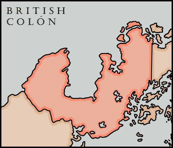
Not too complicated of a map, so I decided to also test out a new coloring method.
Started in 1881 by the French and constructed primarily through poorly paid blacks and hired Colombians. They had established a 99 year lease on the city of colon and its surrounding area, with additional details that the waters of the canal itself would be considered French possessions. France essentially owned the area until 1885, when the Sino-French war had directed much of Frances attention to the far east. Following a few years of inactivity in the canal, the French transferred construction and ownership to the United Kingdom in 1887, becoming a possession of Jamaica.
With the British now constructing the Canal, interest in the Caribbean were further heightened, with the British sending aid to the Spanish unofficially during the Spanish-American war. Additionally, workers for the Canal were increased as black inhabitants from across the British West Indies were sent to complete the canal as soon as possible. Following its completion in the turn of the century, the British used it to gain favors and concession in exchange for lessening or even removing countries' tolls. They also used it to garner new allies and grow relations with their existing alliances. As the Canal grew, so to did the territory sold to the British in the lease, until British Colon had over three times its original French area.
In 1905, the Canal Zone was organized as it's own colony, British Colon, which made lucrative amounts of money on tolls through Panama. Originally, Colombia was to be granted 50% of these tolls, but following the British coming into possession of the canal, this number dropped to 25%. Additionally Colombia and its allies were given free use of the canal as part of the lease. British Colon had a monopoly on the Central American trade to the pacific until the construction of the Nicaraguan Canal in 1917.
During the Great War, Colombia remained neutral despite being sympathetic to the Entente. In 1915, a Colombian merchant ship was sunk in the canal by British soldiers firing on what was thought to be American ships. As a response, the Colombia occupied the the Canal zone to ensure that no further ships would be fired upon by either the Entente or the Central Powers. The following month, Colombia declared that any attempts to militarize or invade the canal would be seen as a declaration of War by Colombia, with Costa Rica and Haiti both supporting Colombia.
Deleted member 111631
This is a political map I made for my timeline, showing a bunch of stuff that tourists from say, the United States or Canada, would like to know if they were so tempted to take a vacation to the country. Here's a link to the hi-res version because imgur hates fun.

Great map but (to me, anyway) it's really hard to make out the state names even after embiggening the map.
Last edited by a moderator:
Transit map of a surviving Roman Empire (found here)
All railroads lead to Rome, eh? Nice, congrats to your friend.
For curiosity's sake, anyone else a little disappointed Rome never built railroads in OTL? I don't mean steam locomotives and T rail, but just horse drawn trains running on strap rail. Could have been interesting.All railroads lead to Rome, eh? Nice, congrats to your friend.
damein fisher
Banned
This is a political map I made for my timeline, showing a bunch of stuff that tourists from say, the United States or Canada, would like to know if they were so tempted to take a vacation to the country. Here's a link to the hi-res version because imgur hates fun.
Something I found out a few years ago that has ruined New England maps for me is that Maine is a separate state. You might know that Maine was once a non-continuous part of Massachusetts, but what you may not know is that the only reason that it was separated from Massachusetts was to keep the balance between slave states and free states following the admission of Missouri. I just don't see a Maine state in New England as realistic
Something I found out a few years ago that has ruined New England maps for me is that Maine is a separate state. You might know that Maine was once a non-continuous part of Massachusetts, but what you may not know is that the only reason that it was separated from Massachusetts was to keep the balance between slave states and free states following the admission of Missouri. I just don't see a Maine state in New England as realistic
I know this. Maine was settled differently and given a charter as a separate colony far before Massachusetts ever administered it. The POD is well into the 1600s for this timeline.
The dark blue around Thessalonikia Aromanian? And strange there aren't Turks in Dobruja. Though not as strange as the lack of Moldavians, and why Vlach and Bulgars are shown as being so similar linguistically. Or at least I assume that is why they are both yellow. And what happened to the Saxons and Swabian scattered around everywhere during OTL?
There's no Slavic invasions ittl, which kinda throws the whole Balkan linguistic landscape into a twist.
Do I spy a surviving Pannonian Romance language??
pls pls pls
*EDIT- Also, would it be too much to ask what general time period this map depicts?
Yup! That's Pannonian Romance.
There's not really a set date, but most languages are from Late Antiquity.
Violet are probably Illiryan languages.
Nope! Honestly I'm of the theory that Albanian is the last remnant of Ilyrian, so it's red.
A little clue: the language that occupies most of the Pannonian Basin is the only Turkic language in the map. The blue languages are also geographically close to it iOTL.
I'm going to take the wild guess of the Bolgars from Russia moving to Pannonia instead of the Magyars or the Huns staying put.A little clue: the language that occupies most of the Pannonian Basin is the only Turkic language in the map. The blue languages are also geographically close to it iOTL.
The green Turkic language in the Pannonian Basin must be the Avars, since they settled there in OTL. I'm still pretty stumped on the indigo group in the western Balkans, but I'm gonna go with Iranian languages, like Alans and Iazyges.
I'm going to take the wild guess of the Bolgars from Russia moving to Pannonia instead of the Magyars or the Huns staying put.
Yes! The Pannonian language is Oghur Turk, the language of the Bolghars, the modern Chuvashes, and (maybe possibly probably) the Huns.
The green Turkic language in the Pannonian Basin must be the Avars, since they settled there in OTL. I'm still pretty stumped on the indigo group in the western Balkans, but I'm gonna go with Iranian languages, like Alans and Iazyges.
There's an Avar remnant but it's not in the Pannonian Basin - Avar is in the Carpathian mountains around Moldova.
damein fisher
Banned
I know this. Maine was settled differently and given a charter as a separate colony far before Massachusetts ever administered it. The POD is well into the 1600s for this timeline.
In that case, nevermind, Great Map!
- Status
- Not open for further replies.
Share: