My attempt at the UK. dont know however if London shouldnt be depicted as Secular or Sunni.
You are using an out of date browser. It may not display this or other websites correctly.
You should upgrade or use an alternative browser.
You should upgrade or use an alternative browser.
URHAFAH: Universal Historical Atlas For AlternateHistorians
- Thread starter Tomislav Addai
- Start date
only half of valais/wallis (Switzerland) is romand/arpitan, the other half is alemannic german. also are canton ethnicities still a thing? as for wales, it depends, for example u origanlly coloured dyfed/Pembrokeshire as welsh even tho its been english speaking for over a hundred years. also north east wales was green despite its close ties with the wirral and chester. the south walian valleys have a stronger welsh identity than deeside. tho id say north east wales as depicted on the map would be strongly welsh, even having decent number of welsh speakers despite them being the minority.
london is christian (48%) with only 20% non-religious and 12% muslim
 the valais/wallis border plus german italy
london is christian (48%) with only 20% non-religious and 12% muslim
Last edited:
For Valais, it was not divided into two on the original map. The power Francophone part is more populous than the German-speaking part. The ethnicities depicted are:only half of valais/wallis (Switzerland) is romand/arpitan, the other half is alemannic german. also are canton ethnicities still a thing? as for wales, it depends, for example u origanlly coloured dyfed/Pembrokeshire as welsh even tho its been english speaking for over a hundred years. also north east wales was green despite its close ties with the wirral and chester. the south walian valleys have a stronger welsh identity than deeside. tho id say north east wales as depicted on the map would be strongly welsh, even having decent number of welsh speakers despite them being the minority.
london is christian (48%) with only 20% non-religious and 12% muslim
the valais/wallis border plus german italy
Swiss German, Arpetan and Lombard (Ticino) to show the linguistic divide.
For Wales I have no idea how to accurately show the thing. My understanding is that you have:
- Welsh-speaking Wales, with a strong identity in regions like Gwynedd.
- Anglophone Wales, with strong Welsh identity, like Glamorgan
- Eastern valleys like Powys, Anglophone with strong ties eastwards.
London, yes it is coloured Anglican on the map
I would recommend using a different color for the South German provinces of the South of the former grand-duchy of Baden differently, than the provinces of former Württemberg. For local identities in this area, people of South-Baden and Württemberg are in some sort of rivalry, and people in South-Baden are still nostalgic for their own state in the age of the grand-duchy in the 19. century. Also the dialect between people from Swabia/Würtemmberg is different from the Allemanic dialect spoken in South-Baden.
I see. Is it only the matter with South Baden, or all of Baden?I would recommend using a different color for the South German provinces of the South of the former grand-duchy of Baden differently, than the provinces of former Württemberg. For local identities in this area, people of South-Baden and Württemberg are in some sort of rivalry, and people in South-Baden are still nostalgic for their own state in the age of the grand-duchy in the 19. century. Also the dialect between people from Swabia/Würtemmberg is different from the Allemanic dialect spoken in South-Baden.
Norther Baden (north of Karlsruhe probably identifies itself more with the Palatinate)I see. Is it only the matter with South Baden, or all of Baden?
Probably follow the borders of various German dialects.I see. Is it only the matter with South Baden, or all of Baden?

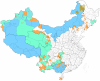
China fixed accordingly. Cultures correspond to languages, such as Mandarin and Cantonese...The ethnic groups in China are one reason using a base showing every prefecture and most/all counties would be sensible IMO:
View attachment 483009
@Zurirach Adankar also take a look at Baden.
And the linguistic map.
So I have reached my capacity to reasonably map cultures. To map until now uncharted areas would require quite some research,.
2019ADReligion
Present day URHAFAH religious map. Apart for China, where the accuracy is debatable, I humbly declare this to be one of the most accurate maps to be found online.
Last edited:
Plus here are some additions to the 1915 map. Notice Antoinism in Belgium and Burkhanism in the Altai
Some of the river borders were translated into provincial borders, such as the Danube in Hungary or the Mississippi or the Rio Grande. Others were not. I was not the mapmaker, and I have changed only very few provincial borders. (Plus I ve changed some borders in Bosnia and Syria)I haven't read every comment here, but what about rivers? Many ancient borders were based on them.
Yes, I am putting them below.Are there up-to-date versions of the cultural, linguistic, and political maps?
Religion, today:
Languages, today:
Cultures, today:
The political map and (possibly forms of government map) were not drawn, due to the mere fact that there are so many of them. Showing present political situation.
As a bonus, religion in 1915:
Attachments
I ve played around with the world map at 1915. Please tell me what to do with Korea, and be happy to remind me of any mistakes.
@Blacklister3000 not saying it is 100% accurate, and as you can see I used the present day map as base in most places
Europe, USA and Middle East are guaranteed, India is as well. For the rest, I used rough assumptions, such as pagan areas in Africa and the Amazon from Extended Timeline mod in EU4. Papua I know got converted relatively recently; enlarged Reformed areas in South Africa according to areas of Boer majority. Russia had minority religious populations inflated, in case of Old Believers and Mennonites.
As for China and Korea, I assume China would have less Christians and Korea more. Dunno.
Greenland is going to be the same, for Canada I believe a reliable source from that time will pop up. Alaska- I do not know, I believe more native and more Orthodox
Should I colour all of Finland Lutheran then?I don't think North Karelia is that orthodox.
Share: