You are using an out of date browser. It may not display this or other websites correctly.
You should upgrade or use an alternative browser.
You should upgrade or use an alternative browser.
WIP Map Thread
- Thread starter B-29_Bomber
- Start date
-
- Tags
- work in progress
Making a military-political alliance map of 1975 (that year chosen because 72-76 was the time period when UBSC was the largest) for the link in my signature. Map currently showing the socialist world in three colours. the Union of Britannic Syndicalist Commonwealths (this timelines USSR equivalent), Chinese Social Republic (think OTL PRC but Trotskyist rather than Maoist) and its two puppets (later, after dissolution of UBSC remaining socialist states mostly ideologically shifted towards China), with the final colour being all other socialist states (mostly Britannic clients but USSA (eastern US) is quite independent). Borders outside of the socialist world currently showing situation of 2020, haven't edited those parts yet. Oh yeah btw Cuba and Hispaniola are one state (Free Socialist Union of the Antilles).
nearly finished the South African maps, doing Durban took a long time. Nevertheless, here is Natal , westo f the Tugela river, completed. Notice the one Indian-majority distrcit (Coloured purple) in the suburbs of Durban


This looks so cool I wanna know all about it, that Kansas-Oklahoma border is wack as all hellSomething for Fun, a sort of Post-Southern Collapse Circa 1900, cramming in everything i find interesting from other maps plus some original stuff into one beautiful Clusterfuck. Don't know if i should put the Free State of Jones in or not.
So I have been working on a big project for nearly 4 months now over China, and I'd like to get some of your (no one person in particular) opinions on how this map looks and if it can be improved or made much easier to understand.
This is part of the 16 kingdoms between 304-376. Does it look good? Is there anything you can recommend that would make it easier to understand?
A legend to clarify what the stripes represent would be helpful, but what's their purpose anyways? Also I spot historical coastline changes, good job there.View attachment 693405
So I have been working on a big project for nearly 4 months now over China, and I'd like to get some of your (no one person in particular) opinions on how this map looks and if it can be improved or made much easier to understand.
This is part of the 16 kingdoms between 304-376. Does it look good? Is there anything you can recommend that would make it easier to understand?
The stripes are showing who controlled territory but their territory overlap on one another. Originally I wanted to separated all the 16 kingdoms, 5D and 10 Kingdoms, and Warlords, but the template map I created was almost as tall as THICC, and I couldn't even open it, so I had to compress it.A legend to clarify what the stripes represent would be helpful, but what's their purpose anyways? Also I spot historical coastline changes, good job there.
But yes, I'll definitely make sure to make a legend
And yeah it's about time we started mapping those, especially since Kolchak made a whole video dedicated to them
Last edited:
so the states in the middle are being occupied by several powers? i dont know how else to read the stripes. but its not clear who all the occupiers are? unless some of the occupied are also occupiers of other places? or not all of the occupiers have been drawn in yet? (some more southerly warring states?)
The stripes just show territory that was controlled by more than 1 power over the period of 304-376. As for who the occupiers are, I am now making a key which will show all of them. Also, the map is finished unless anyone suggests I add in anything elseso the states in the middle are being occupied by several powers? i dont know how else to read the stripes. but its not clear who all the occupiers are? unless some of the occupied are also occupiers of other places? or not all of the occupiers have been drawn in yet? (some more southerly warring states?)
Yes, but tell me what you mean by compositeso its a composite?
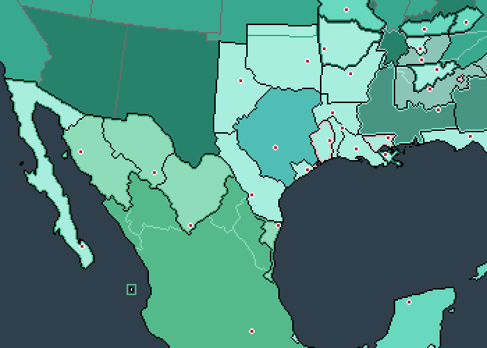
Update: Turns out invading Mexico was a lot harder than expected, only being able to annex Veracruz, Baja and a bit of Sonora ( Now the ''William Walker Republic''), and leaving the rest as petty ''Cotton Kingdoms'' (with the outlined ones having fell before The Collapse, lasting from about 4 weeks to 6 years).
Also color scheme:
Light blue: States emerging from the CSA
Grey: Confederate ''Successor States''
Light green: Confederate Filibuster states
Turquoise: Part of the American sphere
Dark blue lining: İntegrating into the Union
Pink lining: Socialist States (Each one more different than the next)
Bright blue lining: Southron System (From ToixStory's work of the same name)
Here is one that I'm working on, which (with not set PoD) is basically a wank for island nations and islands in general.

Current list of major powers;
United States of Australia and Oceania
United Kingdom of Great Britain
Japan
South China (Taiwan, Hanian, Hong Kong, and Macau)
Sicily
Merina Kingdom
Current list of major powers;
United States of Australia and Oceania
United Kingdom of Great Britain
Japan
South China (Taiwan, Hanian, Hong Kong, and Macau)
Sicily
Merina Kingdom
Part of me wants to guess "The Silent Stars Go By".Decided to fill in the rest of that EireWank world...a virtual cookie to the one who identifies the AH novel I stole ideas from.
View attachment 694334
Share: