The Vassals next to Yunnan are called the Shan states collectively. Unfortunately, I don’t remember them all of the top of my head except for Sipsong Panna and Kengtung.
@Admiral A. Kolchak ok, what are the adjustments i need to make to the provinces to make them historically accurate for ming china 1429?
@Sharklord1 this is my progress so far. also i know ive already done 20 questions with you on this, but what are the vassal states bordering yunnan called? ill need the tibet ones eventually for colouring but i dont need them yet.
You are using an out of date browser. It may not display this or other websites correctly.
You should upgrade or use an alternative browser.
You should upgrade or use an alternative browser.
WIP Map Thread
- Thread starter B-29_Bomber
- Start date
-
- Tags
- work in progress
Brought over slowly by multiple nomadic hordes invading their way to Europe. They... somehow retained their culture for a very long time, moving around until they came across and fell in love with the Alföld and decided to stay there. Yeah. I just wanted a Sinitic group in Europe. Don't think about it too much.How did the old Sichuanese end up all the way in Pannonia?
aight i swear im not going to do this for every microupdate i make, but imma need some help with sichuan and northern zhilli
(as in, i know atleast some of the white area is supposed to go to them, but idk how much, or if some adjoining coloured area should also be given to them to make the border, since the white areas created panhandles i dont think are meant to be there)
the white areas around sichuan are zunyi prefecture level city and badong county.
the white area above northern zhilli is just where the prc/qing province border ran out when i put it in sharklord's ming.
oh, and the white between sichuan and yunnan is because i saw a ming yunnan map on wikipedia and im not confident witch of my two lines follows that part of it closer. (also i think it showed that the bits of modern guizhou directly below the panhandle of modern yunnan should also be part of sichuan.

 commons.wikimedia.org
@Admiral A. Kolchak

oh, also if anyone could tell me if that is a good or bad source map for vietnam thatd also be helpful
(as in, i know atleast some of the white area is supposed to go to them, but idk how much, or if some adjoining coloured area should also be given to them to make the border, since the white areas created panhandles i dont think are meant to be there)
the white areas around sichuan are zunyi prefecture level city and badong county.
the white area above northern zhilli is just where the prc/qing province border ran out when i put it in sharklord's ming.
oh, and the white between sichuan and yunnan is because i saw a ming yunnan map on wikipedia and im not confident witch of my two lines follows that part of it closer. (also i think it showed that the bits of modern guizhou directly below the panhandle of modern yunnan should also be part of sichuan.
File:1582年云南地图-无文字.svg - Wikimedia Commons
@Admiral A. Kolchak
oh, also if anyone could tell me if that is a good or bad source map for vietnam thatd also be helpful
Last edited:
Update:View attachment 699116
Really stupid map I'm making where I revive ancient ethnicities for fun. Currently taking suggestions for any interesting groups I can add to this.
Here's what every country is supposed to be:
View attachment 699117View attachment 699118
View attachment 699119
Here's an improved Google document explaining what everything is: https://docs.google.com/spreadsheets/d/1SUyRp2FeLTcR_ncWNwFzFfXMbjtU25RD90TXTHYzHX0/edit?usp=sharing
Anyone got anything for Scandinavia? I know there were a bunch of tribes in the area but I can't find any good maps or information on them.
Inaria - which does not include the lake Inari...Update:
View attachment 700599
Here's an improved Google document explaining what everything is: https://docs.google.com/spreadsheets/d/1SUyRp2FeLTcR_ncWNwFzFfXMbjtU25RD90TXTHYzHX0/edit?usp=sharing
Anyone got anything for Scandinavia? I know there were a bunch of tribes in the area but I can't find any good maps or information on them.
Update:
View attachment 700599
Here's an improved Google document explaining what everything is: https://docs.google.com/spreadsheets/d/1SUyRp2FeLTcR_ncWNwFzFfXMbjtU25RD90TXTHYzHX0/edit?usp=sharing
Anyone got anything for Scandinavia? I know there were a bunch of tribes in the area but I can't find any good maps or iformation on them.

File:Scandza.PNG - Wikimedia Commons
A sort of little project I've had in the back of my mind for some time.
It takes place in a distant future (about 10,000 years after our era) where the last industrial and robotic civilization is in Africa.
In this world, after a few millennia of global warming due to human activities (but also to the earth cycles), the planet is experiencing a new ice age.
Most humans are unrecognizable because of genetic and robotic manipulations. The few humans who look like us are parked in reserves and serve as a food source for the rest of society.
Nature is also unrecognizable. The ravages of civilization and climate change have taken their toll on the wilderness, which now no longer exists. Only plants, animals, mushrooms and other hybrids, produced by mankind through genetic engineering, remain. The oceans have become unhealthy and most of the rivers in Africa have been diverted inland.
This last industrial civilization is curious. On some points it is backward (whether in the social hierarchy, certain customs etc.) but in others it is still in the forefront (quantum computers, high speed trains and travel in orbit).
I will try to rework all this one day.
KewlView attachment 700892
A sort of little project I've had in the back of my mind for some time.
It takes place in a distant future (about 10,000 years after our era) where the last industrial and robotic civilization is in Africa.
In this world, after a few millennia of global warming due to human activities (but also to the earth cycles), the planet is experiencing a new ice age.
Most humans are unrecognizable because of genetic and robotic manipulations. The few humans who look like us are parked in reserves and serve as a food source for the rest of society.
Nature is also unrecognizable. The ravages of civilization and climate change have taken their toll on the wilderness, which now no longer exists. Only plants, animals, mushrooms and other hybrids, produced by mankind through genetic engineering, remain. The oceans have become unhealthy and most of the rivers in Africa have been diverted inland.
This last industrial civilization is curious. On some points it is backward (whether in the social hierarchy, certain customs etc.) but in others it is still in the forefront (quantum computers, high speed trains and travel in orbit).
I will try to rework all this one day.
This is a fucking amazing aesthetic, one that I don't think I've seen pulled off to this extent before. Well done.View attachment 700892
A sort of little project I've had in the back of my mind for some time.
It takes place in a distant future (about 10,000 years after our era) where the last industrial and robotic civilization is in Africa.
In this world, after a few millennia of global warming due to human activities (but also to the earth cycles), the planet is experiencing a new ice age.
Most humans are unrecognizable because of genetic and robotic manipulations. The few humans who look like us are parked in reserves and serve as a food source for the rest of society.
Nature is also unrecognizable. The ravages of civilization and climate change have taken their toll on the wilderness, which now no longer exists. Only plants, animals, mushrooms and other hybrids, produced by mankind through genetic engineering, remain. The oceans have become unhealthy and most of the rivers in Africa have been diverted inland.
This last industrial civilization is curious. On some points it is backward (whether in the social hierarchy, certain customs etc.) but in others it is still in the forefront (quantum computers, high speed trains and travel in orbit).
I will try to rework all this one day.
Though, I do think you could do with changing the internals colour a bit.
Okay, first thing, do not use the QBAM to trace Chinese subdivisions, ever. Use this.
@Admiral A. Kolchak ok, what are the adjustments i need to make to the provinces to make them historically accurate for ming china 1429?
@Sharklord1 this is my progress so far. also i know ive already done 20 questions with you on this, but what are the vassal states bordering yunnan called? ill need the tibet ones eventually for colouring but i dont need them yet.
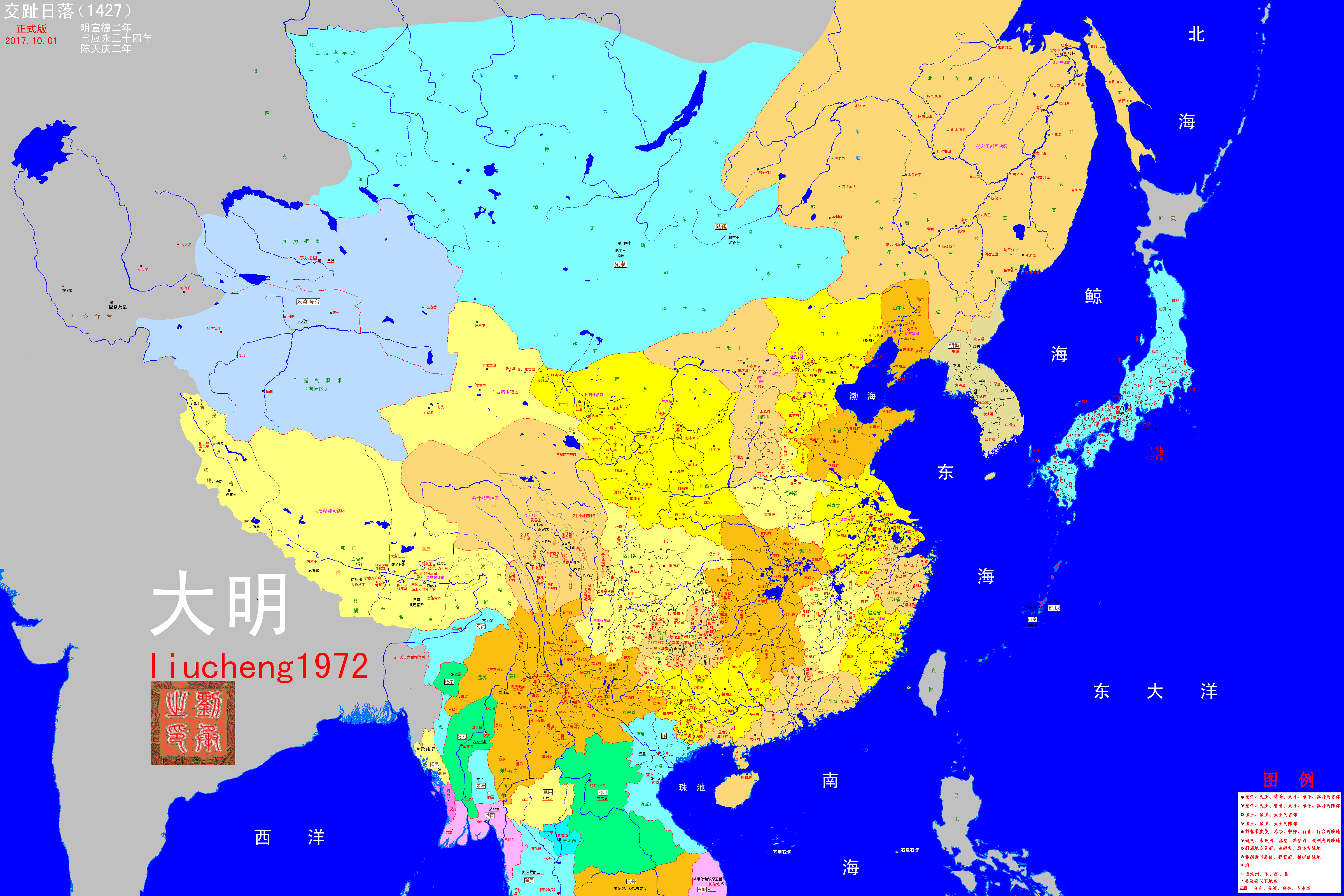
Here is a map of Ming subdivisions in 1427
Here is a map of modern Chinese subdivisions in about the same projection:

Both of the white areas adjoining Sichuan were entirely part of Sichuan during the Ming era. The panhandles existed.aight i swear im not going to do this for every microupdate i make, but imma need some help with sichuan and northern zhilli
(as in, i know atleast some of the white area is supposed to go to them, but idk how much, or if some adjoining coloured area should also be given to them to make the border, since the white areas created panhandles i dont think are meant to be there)
the white areas around sichuan are zunyi prefecture level city and badong county.
the white area above northern zhilli is just where the prc/qing province border ran out when i put it in sharklord's ming.
oh, and the white between sichuan and yunnan is because i saw a ming yunnan map on wikipedia and im not confident witch of my two lines follows that part of it closer. (also i think it showed that the bits of modern guizhou directly below the panhandle of modern yunnan should also be part of sichuan.
File:1582年云南地图-无文字.svg - Wikimedia Commons
@Admiral A. KolchakView attachment 700533
oh, also if anyone could tell me if that is a good or bad source map for vietnam thatd also be helpful
i just figured theyd be less skinny, thankyou though 😊Both of the white areas adjoining Sichuan were entirely part of Sichuan during the Ming era. The panhandles existed.
500 social credit points have been added to your account. But seriously, this will be one nice work once done.Sort of an alt-Doomsday 1983, in which China stays out of WWIII and does alright.
View attachment 701868
Absolute bangerSort of an alt-Doomsday 1983, in which China stays out of WWIII and does alright.
View attachment 701868
I don't think it was possible that China would stay out of WW3, not because they wanted to, but because Russia hated them strongly during that time.Sort of an alt-Doomsday 1983, in which China stays out of WWIII and does alright.
View attachment 701868
Dear mother of god…Sort of an alt-Doomsday 1983, in which China stays out of WWIII and does alright.
View attachment 701868
Share: