WIP Map Thread

I imagine they might rename it anyways. Walfischbucht and Walfischbai are both options, though it people tried to have every map using only the names locals use for a city it would take months of research at times. Is Malawi part of Zambia? And under what circumstances did the Germans lose much of the Caprivi Strip? There is some good farmland there, though I imagine minerals are the main focus for this colony. And fun to see what you did with South Rhodesia. I can only imagine the borders and the power-sharing involved. However, I do feel that if the box is speaking on German Southwest Africa that it should be zoomed in on there. Perhaps also showing historical border changes. Depends on the focus of the map.

The infobox contains information on SW Africa.

EDIT: I fixed the Caprivi Strip. :)
 
Last edited:
southwestafrica_by_kitfisto1997-dbq11pw.png


Here's the *nearly* finished product! :D

Just gotta change some of the city names and stuff like that. Plus I gotta do a write-up and maybe a little vignette for ya'll to enjoy! :)
 
I don't usually do WIPs on here, but since I need to give myself a kick in the butt here is my latest WIP that I hope to finish in 2-3 weeks if all goes well.

2017.png
 
Thank you! I am actually considering making a pixel art comic in the future. :)
To be honest, doing a pixel art comic might be a hell of a thing to do, speaking as someone who dabbled with pixel stuff for Sprite Wars and for personal use.

Anyways, I'm cross posting this WIP again to show some progress made for my TL:
5suCHz8.png
 
To be honest, doing a pixel art comic might be a hell of a thing to do, speaking as someone who dabbled with pixel stuff for Sprite Wars and for personal use.

Anyways, I'm cross posting this WIP again to show some progress made for my TL:
5suCHz8.png
It's a hell of a thing to do anything right I think :) Will still be worth it I think.
 
You would be correct.
One pet peeve, though: Sweden, not Norway, should be part of the german alliance system. The union between both countries was dissolved due to geopolitical leanings, as Norway leaned more pro-british and Sweden leaned more pro-Germany.
 
To be honest, doing a pixel art comic might be a hell of a thing to do, speaking as someone who dabbled with pixel stuff for Sprite Wars and for personal use.

Anyways, I'm cross posting this WIP again to show some progress made for my TL:
SNIP

> Uber-Yugoslavia
> Mongolia borders that actually look A E S T H E T I C A L L Y pleasing

YES. :D

Is this a Metal Slug map?
 
> Uber-Yugoslavia
> Mongolia borders that actually look A E S T H E T I C A L L Y pleasing

YES. :D

Is this a Metal Slug map?
Yep the same one, just with more touches put in. I'll admit I used the Attack mission list from MSA (Metal Slug Attack) to help me figure out which countries are mainly involved; the rest is pure speculation/imagination on my part.
 
Yep the same one, just with more touches put in. I'll admit I used the Attack mission list from MSA (Metal Slug Attack) to help me figure out which countries are mainly involved; the rest is pure speculation/imagination on my part.

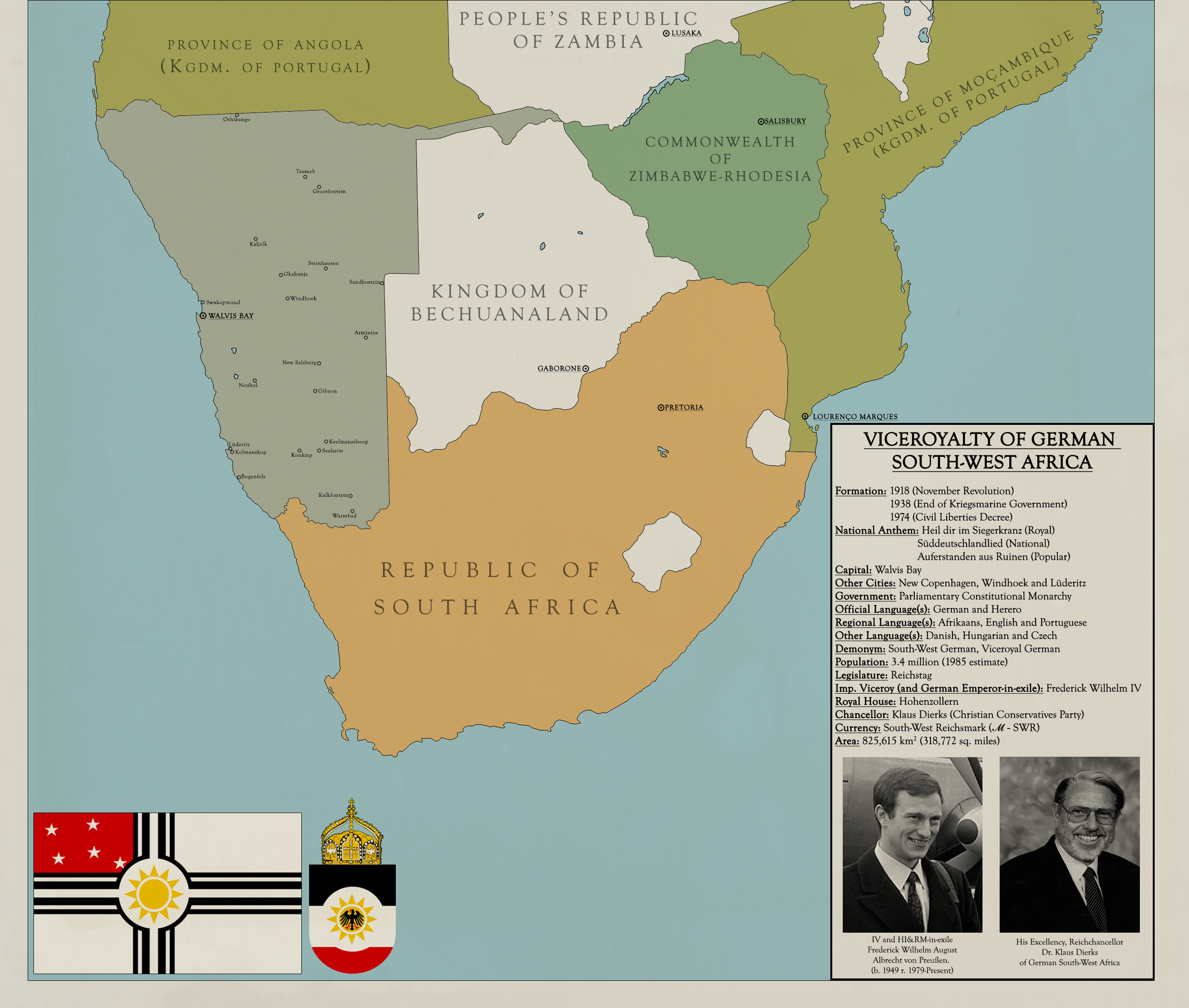
NICE! I'm working on the write-up for the SW Africa map. Here's a preview... ;)

--

"By the time the Great War broke out in Europe in 1914, South-West Africa and specifically the (now former) capital city of New Berlin (referred to as ‘Windhoek’ by foreigners) were booming in not only size, but also population with the capital holding at least 45,000 people, while the entire colony was home to at least 320,000. The only thing standing between an Entente invasion via British-owned South Africa and Bechuanaland was the vast Namib Desert and a Colonial Militia that was understaffed, wielded out-of-date armaments and subjected their Heroro-majority ‘Coloured Battalions’ to indiscriminate and disproportionate amounts of punishment when compared to the regular militias.

The outbreak of the Great War was a shock to the colonial officials as South African forces marched into the colony, quickly occupying the heavily populated southern coast, while forces from the Bechuanaland Protectorate (British policy in OTL Botswana took a different turn here) took the Caprivi Strip. The Colonial Militias fought against the well-trained and numerically superior British forces with a level of ferocity and knowledge of the environment that gave them enough of an edge to keep the Entente forces from taking Windhoek. A combination of trench-warfare in some areas and full-on irregular fighting kept the British from advancing as far as the small mining town of Helmeringhausen. The day that the Siege of Helmeringhausen was lifted – October 7th – is now a national holiday in the modern Viceroyalty. The slow trickle of updated equipment and men from the German Empire further bolstered the resolve of the Militas, as the British exclave of Walvis Bay fell in 1916 and the British were pushed back across the Orange River by the end of the war in 1918. With the Boer Revolt and the subsequent establishment of the short-lived Second South African Republic plus the general fatigue and lack of supplies ended in the South African government suing for peace with the colonial officials, handing over the port city of Walvis Bay and the Penguin Islands to the Germans.

Despite such a miraculous victory over the British in West Africa, the situation in both the other..."
 
FederationofRhodesia.png


Before I go to finish off an assignment for Uni... I've been messing with MBAM maps for the past hour and guess what country I decided to mess with? :p
 
Top