You are using an out of date browser. It may not display this or other websites correctly.
You should upgrade or use an alternative browser.
You should upgrade or use an alternative browser.
The Warlord Atlas
- Thread starter Linbot
- Start date
These guys, apparently.
Weird to think a remnant of the Chagtai khaganate survived into the 20th century.
1920
The Republic of China in 1920:


1920, Undetermined Date:
Chinese troops withdraw from Russia.
January:
Fengtien secures control over the northeast. Chinese troops invade Uriankhai. Old Gui Clique occupies Guangdong and expels the Guomindang, ending the First Constitutional Protection Movement.
April:
Anhui loyalists set up a military base in Wuchang.
July:
Chen Jiongming's Yue Clique revolts against the Old Gui Clique. Zhili and Northeast Army troops attack the Anhui Clique in Beijing, beginning the Zhili-Anhui War. In 13 days of combat Zhili troops decisively defeated the Anhui Clique and the victors occupy Beijing. Concurrently Zhili troops retake Wuchang. The Northeast Army also moves into the northwest. Across China the Anhui Clique's authority begins to fall apart.
August:
The Yue Clique declares for the GMD, beginning the Second Constitutional Protection Movement.
September:
The governor of Anhui province is overthrown by the Zhili Clique.
October:
Old Gui Clique is expelled from Guangdong.
November:
The Xiang Clique's leadership is deposed by a new clique that recognises the Zhili Clique.
December:
Ma Clique breaks up.
1921
The Republic of China in 1921:


January:
Russian troops invade Mongolia. Zhili Clique takes Xi'an.
February:
Russians capture Urga.
March:
Russians attack Choir.
April:
Chinese troops withdraw from Mongolia.
May:
Hui governor established in Suiyuan.
June:
Yue Clique invades Guangxi.
July:
Sichuan accepts the authority of the Zhili Clique.
August:
Yue Clique destroys the Old Gui Clique.
1922
The Republic of China in 1922:


February:
Yue Clique launches a GMD-supported invasion of Hunan. Washington Naval Conference restores Shandong and Qingdao to China.
April:
Yue Clique withdraws from Hunan. New Gui Clique established in Guangxi. Qian Clique accepts Zhili authority. Zhili Clique destroys Shaan Clique. In late April the Northeast Army attacked the Zhili Clique, beginning the First Zhili-Fengtien War. Zhili forces were defeated and the NE Army captured Tianjin.
May:
Northeast Army defeated at Tianjin. Their forces are there expelled from Zhili province.
June:
First Zhili-Fengtien War ends with the Northeast Army withdrawing from Zhili, Beijing, and the Northwest. Yue Clique rebels against the GMD, expelling Sun Yixian from Guangzhou.
Last edited:
I noticed that I forgot to remove those borders. The colour had been removed because different factions of Russians remained in effective control from Mongolia from 1921. So I decided that the formal removal of the Bogd Kaan, formally still a Chinese local leader, would be appropriate to show Mongolia's final separation from China. Although it was mainly an excuse to remove the bordersIs the Soviet overthrow of the Mongolian khan why the borders between Russia and Mongolia vanish in the last map or is that an oversight?
")
Okay, wait, I noticed that I also show other non-Chinese political borders, so I guess I'll add them back in. Stupid me.I noticed that I forgot to remove those borders. The colour had been removed because different factions of Russians remained in effective control from Mongolia from 1921. So I decided that the formal removal of the Bogd Kaan, formally still a Chinese local leader, would be appropriate to show Mongolia's final separation from China. Although it was mainly an excuse to remove the borders
Okay, wait, I noticed that I also show other non-Chinese political borders, so I guess I'll add them back in. Stupid me.
Yeah, glad you keep those borders. It gives context.
1923
The Republic of China in 1923:


January:
Guomindang forces establish themselves in Canton. By this time the GMD leadership has developed a notably authoritarian slant, although the right wing has yet to secure control. Meanwhile the Anhui governor of Fujian is overthrown by a Zhili-backed warlord.
March:
Fujian integrated into the Zhili Clique.
April:
Dian Clique leader Tang Jiyao conquers Guizhou. Its former leaders seek refuge in Sichuan.
October:
A rapprochement between the Zhili and Anhui Cliques is sealed by the transfer of Shandong to the Anhui Clique. The Zhili Clique, now without a major rival outside of the margins of the country, secures control of the presidency.
Who exactly controlled Aksai Chin during this period? It's normally shown as part of India on maps of the British Raj, but these maps seem to show it as part of Tibet or Xinjiang.
Good question.
From the wiki article on it:
The Johnson Line
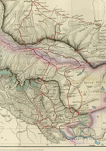
Map of Central Asia (1878) showing Khotan (near top right corner). The previous border claimed by the British Indian Empire is shown in the two-toned purple and pink band with Shahidulla and the Kilik, Kilian and Sanju Passes clearly north of the border.

William Johnson, a civil servant with the Survey of India proposed the "Johnson Line" in 1865, which put Aksai Chin in Kashmir.[13] This was the time of the Dungan revolt, when China did not control most of Xinjiang, so this line was never presented to the Chinese.[13] Johnson presented this line to the Maharaja of Kashmir, who then claimed the 18,000 square kilometres contained within,[13] and by some accounts territory further north as far as the Sanju Pass in the Kun Lun Mountains. Johnson's work was severely criticized for gross inaccuracies, with description of his boundary as "patently absurd".[14] Johnson was reprimanded by the British Government and resigned from the Survey.[13][14][15] The Maharajah of Kashmir constructed a fort at Shahidulla (modern-day Xaidulla), and had troops stationed there for some years to protect caravans.[16] Eventually, most sources placed Shahidulla and the upper Karakash River firmly within the territory of Xinjiang (see accompanying map). According to Francis Younghusband, who explored the region in the late 1880s, there was only an abandoned fort and not one inhabited house at Shahidulla when he was there - it was just a convenient staging post and a convenient headquarters for the nomadic Kirghiz.[17] The abandoned fort had apparently been built a few years earlier by the Kashmiris.[18] In 1878 the Chinese had reconquered Xinjiang, and by 1890 they already had Shahidulla before the issue was decided.[13] By 1892, China had erected boundary markers at Karakoram Pass.[14]
In 1897 a British military officer, Sir John Ardagh, proposed a boundary line along the crest of the Kun Lun Mountains north of the Yarkand River.[16] At the time Britain was concerned at the danger of Russian expansion as China weakened, and Ardagh argued that his line was more defensible. The Ardagh line was effectively a modification of the Johnson line, and became known as the "Johnson-Ardagh Line".
The Macartney–Macdonald Line
Main article: Macartney–MacDonald Line

The map given by Hung Ta-chen to the British consul at Kashgar in 1893. The boundary, marked with a thin dot-dashed line, matches the Johnson line[19]
In 1893, Hung Ta-chen, a senior Chinese official at St. Petersburg, gave maps of the region to George Macartney, the British consul general at Kashgar, which coincided in broad details.[19]
1899 to 1947
Both the Johnson-Ardagh and the Macartney-MacDonald lines were used on British maps of India.[13] Until at least 1908, the British took the Macdonald line to be the boundary,[21] but in 1911, the Xinhai Revolution resulted in the collapse of central power in China, and by the end of World War I, the British officially used the Johnson Line. However they took no steps to establish outposts or assert actual control on the ground.[14] In 1927, the line was adjusted again as the government of British India abandoned the Johnson line in favor of a line along the Karakoram range further south.[14] However, the maps were not updated and still showed the Johnson Line.[14]

Postal Map of China published by the Government of China in 1917. The boundary in Aksai Chin is as per the Johnson line.
From 1917 to 1933, the Postal Atlas of China, published by the Government of China in Peking had shown the boundary in Aksai Chin as per the Johnson line, which runs along the Kunlun mountains.[19][20] The Peking University Atlas, published in 1925, also put the Aksai Chin in India.[22] When British officials learned of Soviet officials surveying the Aksai Chin for Sheng Shicai, warlord of Xinjiang in 1940-1941, they again advocated the Johnson Line.[13]At this point the British had still made no attempts to establish outposts or control over the Aksai Chin, nor was the issue ever discussed with the governments of China or Tibet, and the boundary remained undemarcated at India's independence.[13][14]
Since 1947


The bit about the British abandoning the Johnson Line in favour of a line along the Karakoram range further south would seem to suggest actual control along a line running as a combination of the Macartney-MacDonald line and the Foreign Office line of 1873 running to Lanak La in the second map in the quote above (as can be seen from the second map in this article):
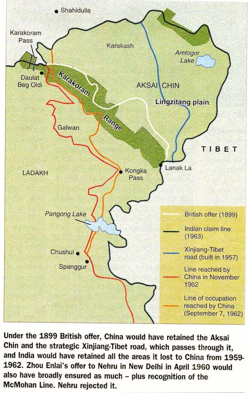
I would suggest that the following two maps I did modifying the second one from the wikipedia quote in my previous post would be the most reasonably accurate reading of the situation:
(Pink is British/Indian control, Light Green is Chinese control, Grey is no-man's land):
1899-1927:

1927-1945:

(Pink is British/Indian control, Light Green is Chinese control, Grey is no-man's land):
1899-1927:
1927-1945:
I showed Aksai Chin as part of Tibet on my maps since from my research it was not under the control of either China or the Raj, and comparable areas were inhabited primarily by tribesmen or isolated communities with affiliations to the Tibetan Army. Omniatlas, which draws from a lot of sources, also shows it as part of Tibet, although you'll notice that my work contrasts with Omniatlas frequently. @Chris S's research is convincing, though.
1924
The Republic of China in 1924:


1924, Indeterminate Date:
Old Gui Clique returns to Guangxi but is unable to defeat the New Gui.
August:
New Gui Clique aligns with the Guomindang.
September:
Second Zhili-Fengtien War begins. Northeast Army advances into Rehe and Zhili but after suffering heavy casualties they are unable to advance further.
October:
Being Coup: Zhili troops under Feng Yuxiang defect from Wu Peifu's army and found the Guominjun. With the advance of NE Army forces Zhili troops in northeastern Zhili are encircled and surrender. Old Gui Clique defeated by the New Gui.
November:
Jin and Anhui Cliques intervene in Zhili. Zhili Clique is forced to retreat from the province into Central China. Sun Chuanfang's United Provinces faction splits from the main Zhili Clique, although they continue to cooperate closely. A new Anhui Clique government is formed in Beijing. Henan defects from the Zhili Clique in support of the Guominjun but authority there is contested between Hu Jingyi and Liu Zhenhua.
December:
Guominjun takes over most of Zhili province. Jin Clique aligns with Guominjun.
So I've done some more work on that HoI4 mod. There are still some cliques I could add in that existed historically (Song Zheyuan's faction, splitting the Ma Clique, etc.), but I feel that this layout is pretty sufficient for now.

Currently I'm coding a focus tree for Shanxi, and I have a draft for a Kwangtung focus tree. Eventually I plan to add focus trees and unique events and decisions for almost every nation, and possibly overhaul Nationalist or Communist China. That's just an eventually at this point though.
Currently I'm coding a focus tree for Shanxi, and I have a draft for a Kwangtung focus tree. Eventually I plan to add focus trees and unique events and decisions for almost every nation, and possibly overhaul Nationalist or Communist China. That's just an eventually at this point though.
There are also a few issues. The main one is that, with the way HoI4 currently works, I don't think there is a way to have a nation be a puppet of two different nations depending on which start date it is. There's probably an obvious fix I'm missing here, but that's what you get for being a self-taught modder. So for now I can't accurately represent Mengkiang's convoluted history of allegiances, so I'll have to compensate with decision trees for Shanxi and Japan.
I also can't get the Warlord Focus Tree from WtT to work for the new tags, which is frustrating because I have no idea why this happens and said focus tree is a useful placeholder for those warlords until I can make them unique focus trees. So for now they're stuck with the generic focus tree. Even worse the OOBs for Hsikang and Tunganistan just won't load, which is inconvenient, although in Tunganistan's case they begin 1936 in a war with Sinkiang the AI will lose 99% of the time even with a division. Although when I get to that I'll probably make that war focus-triggered since that's the only way to get it to occur in the proper timeframe.
I also find it kind of weird how some of the Centre's generals are actually commanders who served in warlord militaries. So for this mod I'm "repatriating" them to their proper tags.
Another thing about HoI4 is that it seems to suggest that the Centre had virtually no control over the warlords in 1936, which is inaccurate and can lead to some serious memes (like foreign powers boosting XSM's communism or random warlords joining the Axis). So in my mod the small apparent size of Nationalist China is an illusion: their collection of puppets is actually larger than the territory of vanilla Nationalist China.
I also find it a shame that Waking the Tiger turned out to be such a disappointment. It arguably adds just as much content to Germany, and for a DLC that's all about East Asia that's a shame. That's pretty unfortunate because WtT actually introduced some really innovative mechanics. The political power struggle mechanic was really interesting and actually has some basis in reality (Li Zongren's overthrow of Chiang Kai-shek in 1949 can be interpreted as the Guangxi Clique winning its power struggle against Nationalist China).
What I'm trying to do here is build off WtT to make a truly realistic and interesting HoI4 China. Essentially, my mod is what Waking the Tiger should have been, and the Eight Years' War of Resistance mod is basically Road to '56 but for China.
Footnote: I'm not sure if I want to turn this into a dev diary for a HoI4 mod, but here we are I suppose. I'll still keep making Atlas maps, regardless.
Last edited:
Share: