Hey @Tanystropheus42, what ever became of the 1907 British Raj patch you were working on? The work in progress posted on the Historical Map thread months ago looked sharp.
You are using an out of date browser. It may not display this or other websites correctly.
You should upgrade or use an alternative browser.
You should upgrade or use an alternative browser.
The Q-BAM Improvement and Core Thread
- Thread starter iori
- Start date
I ran out of steam on that about a year ago, but not a word of a lie, I was actually planning on starting work on it again with the aim of finally finishing it in the next week or so, so expect progress soon.
To be honest, the whole 1907 map project has been dormant for a while now. The problem is I'm a perfectionist - every last pixel has to be spot on, which makes for good maps but means that it takes a hours for me to get some decent work done. By the end I just got wrapped up in endless geographical patches and tinkering with the basemap; I even spent several months scouring google earth trying to figure out whether every lake visible at this scale was natural or a reservoir (a job that's still unfinished). But after about a year of working on other projects (most of which never saw the light of day unfortunately), I'm probably going to start work on it again just to finish the damned thing off.
Actually, speaking of geographical patches, here's one I whipped up a few days ago for the coast of Australia's Northern Territory;

... and another for Banaba Island; a rather bizarre little anomaly that's legally part of Kiribati but governed by Fiji, and one of only three elevated, phosphate-rich islands in the Pacific along with Nauru and Makatea in French Polynesia. It's even got Kiribati's highest point above sea level (81 metres), so I was quite surprised to find it's not included on any of the QBAM's I could find. Shown with the rest of Kiribati and Nauru for orientation;

To be honest, the whole 1907 map project has been dormant for a while now. The problem is I'm a perfectionist - every last pixel has to be spot on, which makes for good maps but means that it takes a hours for me to get some decent work done. By the end I just got wrapped up in endless geographical patches and tinkering with the basemap; I even spent several months scouring google earth trying to figure out whether every lake visible at this scale was natural or a reservoir (a job that's still unfinished). But after about a year of working on other projects (most of which never saw the light of day unfortunately), I'm probably going to start work on it again just to finish the damned thing off.
Actually, speaking of geographical patches, here's one I whipped up a few days ago for the coast of Australia's Northern Territory;
... and another for Banaba Island; a rather bizarre little anomaly that's legally part of Kiribati but governed by Fiji, and one of only three elevated, phosphate-rich islands in the Pacific along with Nauru and Makatea in French Polynesia. It's even got Kiribati's highest point above sea level (81 metres), so I was quite surprised to find it's not included on any of the QBAM's I could find. Shown with the rest of Kiribati and Nauru for orientation;
G-projector.Is there an easy way to move the centre point of the map? I want to have a 1945 map centred on Japan
Someone did do a pacific-centred version a few years ago - it should be in this thread somewhere.Is there an easy way to move the centre point of the map? I want to have a 1945 map centred on Japan
Could we have the following four patches? I will likely need them.
1. Administrative divisions of Hokkaido
2. Municipalities of Baja California and Baja California Sur
3. Self Administered Zones of Burma/Myanmar
4. The entire Ussuri River, not just the portion forming the Sino-Russian border
1. Administrative divisions of Hokkaido
2. Municipalities of Baja California and Baja California Sur
3. Self Administered Zones of Burma/Myanmar
4. The entire Ussuri River, not just the portion forming the Sino-Russian border
Could we have the following four patches? I will likely need them.
1. Administrative divisions of Hokkaido
2. Municipalities of Baja California and Baja California Sur
3. Self Administered Zones of Burma/Myanmar
4. The entire Ussuri River, not just the portion forming the Sino-Russian border
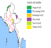
Here's number 3, color coded
Attachments
https://eliiscrazy.deviantart.com/art/W-I-P-1933-Q-BAM-737225394?ga_submit_new=10:1522012350
Here, have a Work-In-Progress Q-BAM of 1933.
I put it on DA because it might make people mad.
(Though I would expect that someone who likes history wouldn't get offended by Nazi imagery...)
((This is for the mods: Yes, I do sh*tpost on my DA. I DO NOT support anything on there unless i explicitly say so. Most of the "controversial" things are JOKES.))
(((So, if you do get offended by controversial jokes, please don't enter...)))
I have a map with better borders for central Europe, especially Germany if you would like to use them!
I have a map with better borders for central Europe, especially Germany if you would like to use them!
And that's a kicked member. Well if anyone wants the maps they are way back towards the beginning of the historical QBAM thread. I'd have to pull them back up.
Deleted member 105545
I mean, I would enjoy them! (and the kick was very fair and reasonableAnd that's a kicked member. Well if anyone wants the maps they are way back towards the beginning of the historical QBAM thread. I'd have to pull them back up.
") )
)Here you go. Sorry for the discrepancy on the reservoir lakes. I really dislike the Schliesen and Ostpreußen borders on most QBAM maps, as they are very inaccurate.
I also added in my own lakes that I felt could be represented here.
The last map is the most up-to-date and accurate.
_edit_edit_edit.png")

I also added in my own lakes that I felt could be represented here.
The last map is the most up-to-date and accurate.
Last edited:
Any chance that Chongqing Municipality can be subdivided? I will need them for my map
Redcoat
Banned
We should do that for the MBAM too... You've been asking for a while so I'll do it today.Any chance that Chongqing Municipality can be subdivided? I will need them for my map
Share: