Yes! The oceans are connected via the Panama Canal!!!Continuing with Central America:
- Bay Islands (Honduras)
- Guatemalan claim on south Belize
- Caribbean coastlines and reefs of Guatemala, Honduras, Nicaragua, Costa Rica, Panama, and Chocó (Colombia)
View attachment 902790
You are using an out of date browser. It may not display this or other websites correctly.
You should upgrade or use an alternative browser.
You should upgrade or use an alternative browser.
The HEART Development and Core Thread
- Thread starter JG Online
- Start date
-
- Tags
- basemap blank maps cartography maps
7# Patch for HEART-1914 addon:
- Protectorate Yemen
- Tripoitaniya
- French indochina (work in progress) & Kouang-Tchéou-Wan
Now starting Central Asia, I think Caspian Sea will be horrorful, but I'll try to do my best
btw I think european part of this addon is ready for 1915-1919 addons


- Protectorate Yemen
- Tripoitaniya
- French indochina (work in progress) & Kouang-Tchéou-Wan
Now starting Central Asia, I think Caspian Sea will be horrorful, but I'll try to do my best
btw I think european part of this addon is ready for 1915-1919 addons

Wow, that's fast. Sometimes I think what kind of stuff you doing irl and have time to do all this (even without 2nd lvl)Patch #91
Finishing up Central America, the Pacific coast now spawns from Seattle to the Darien
Added Guatamala
Added El Salvador
Added Honduras
Added Nicaragua
Added Costa Rica
Added Panama
View attachment 902842
This particular part didn't take superlong, the biggest timesink is coastlines and other natural features of which Tomoto had already done half, I think I managed to draw this in maybe 2 hours?Wow, that's fast. Sometimes I think what kind of stuff you doing irl and have time to do all this (even without 2nd lvl)
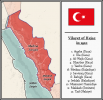
Hi, looks like you colored the autonomous Ottoman provinces wrong, Province of Beirut or Jerusalem wasnt autonomous but Mount Lebanon Mutasarrifate also from 1910 Sanjak of Medina was separated from Province of Hijaz, to curb the separatist ambitions of the Shariffs of Mecca which proved wise and enabled Turkish forces to hold on to Medina during the Arab revolt even until after the end of the first world war.7# Patch for HEART-1914 addon:
- Protectorate Yemen
- Tripoitaniya
- French indochina (work in progress) & Kouang-Tchéou-Wan
Now starting Central Asia, I think Caspian Sea will be horrorful, but I'll try to do my best
btw I think european part of this addon is ready for 1915-1919 addons
View attachment 902797
View attachment 902798
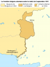
Also Bulgaria-Turkey border was different until 1915, when Turkey ceded some land around Edirne to Bulgaria to sweeten the deal about them entering the war as an ally.
Attachments
Last edited:
Thanks for noticing that! I actually took it from some Q-BAM map of 1914Hi, looks like you colored the autonomous Ottoman provinces wrong, Province of Beirut or Jerusalem wasnt autonomous but Mount Lebanon Mutasarrifate also from 1910 Sanjak of Medina was separated from Province of Hijaz, to curb the separatist ambitions of the Shariffs of Mecca which proved wise and enabled Turkish forces to hold on to Medina during the Arab revolt even until after the end of the first world war.
Also Bulgaria-Turkey border was different until 1915, when Turkey ceded some land around Edirne to Bulgaria to sweeten the deal about them entering the war as an ally.
Just trying to be help. Wikipedia has this for Hejaz vilayet for 1910, presumably for before Sanjak of Medina was decided to be governed directly from the capital and separatedThanks for noticing that! I actually took it from some Q-BAM map of 1914
Hejaz vilayet - Wikipedia
Attachments
Patch #92
Working my way into the Sahel now, I was about to fix up chad reworking some of Alexoidds patched, it should be good now, coastline for lake chad is for 1963, so you can probably fill this up for historic maps, the CARCW is a bit tricky, some of the rebels are allied? Idk how official their alliance is but they have a facebook group apperantly (no joke), so depending on how we wish to show that if at all it might need a rework. There are also some areas in CAR that I left just white because no one controls those areas as fart as I can tell, so take the what as a Terra Nullis colour for HEART.
CARCW is up to date for November 2023
Added the Central African Republique & Civil war
Added Chad
Share: