I see youre a fan of Einsteins theory of time relativity. How many hours have passed? 🤥I am making a map. I anticipate completion within twenty-four hours.
You are using an out of date browser. It may not display this or other websites correctly.
You should upgrade or use an alternative browser.
You should upgrade or use an alternative browser.
Telephone Map Game: 3rd Edition
- Thread starter Entrerriano
- Start date
I'm just waiting for what, two maps?Can we all agree to just end this game? It seems it was a trainwreck from start to finish with skips, time extensions, etc...
Can we all agree to just end this game? It seems it was a trainwreck from start to finish with skips, time extensions, etc...
Nah, if someone is making a map the minimum of decency is to wait.
If you really want to see other maps now just dm previous players to share them
A lot more that I anticipated at the time! I have a thing bound for Entrerriano right now, though.I see youre a fan of Einsteins theory of time relativity. How many hours have passed? 🤥
(The issue was that I had free time on Tuesday, but not on Wednesday or Thursday; it might seem that it took four times as much time as I predicted to finish, but really the factor was more like two.)
Hindustani Person hasn't answered, therefore I'm skipping them.
Now only @X_Eaglefrost_X is left and they've got untill monday.
Now only @X_Eaglefrost_X is left and they've got untill monday.
@ZeSteel, @Gokbay and @Ulyanovsk, I'm missing your maps. Please send them to me as soon as possible, along with some commentary on the thought process/map overall.
I must congratulate List 2 for sending me all the maps in the first time. Only some map commentaries were missing but I've already adressed the respective users.
I must congratulate List 2 for sending me all the maps in the first time. Only some map commentaries were missing but I've already adressed the respective users.
@ZeSteel, @Gokbay and @Ulyanovsk, I'm missing your maps. Please send them to me as soon as possible, along with some commentary on the thought process/map overall.
I must congratulate List 2 for sending me all the maps in the first time. Only some map commentaries were missing but I've already adressed the respective users.
I have just sent the map to you.
This is the culmination of like 3 months of some of our best. Could be interesting to see how it goes.
I dont know about you guys but mine was kinda weird so I have no idea what will happenThis is the culmination of like 3 months of some of our best. Could be interesting to see how it goes.
I too, am excited to see the maps when they are released!I'm excited to see what the final maps will look like!
I never made a map, I excused myself a few pages ago and sent the one I received along to @Hindustani Person@Ulyanovsk please could you send your map? It's the only one missing
...I never made a map, I excused myself a few pages ago and sent the one I received along to @Hindustani Person
Ok then, I guess we are done with the maps. I'll be posting them soon
Results! (Part 1)
Ladies, Gentlemen, and non-Binary users! Here we have...
TELEPHONE MAP GAME: EDITION 3
Initial Map: @Entrerriano

"So for this edition I went with the first thing that crossed my mind, and that was a muslim Rome (or Constantinople) and a Christian Persia. I decided to place the Turks in Mesopotamia instead of Anatolia too, for that extra variety. In hindsight I should probably have done a little bit better, but it's OK I guess."
Entrerriano's map went to ZeSteel and Uebeltank
List 1
Map 1: @ZeSteel

"The thought process here was that I really wanted to try my hands at a munroist style map, and I think I did that well. From Entrerriano's map I saw what seemed to be a declining Roman Caliphate, so I decided to show it's collapse and give a bit of context to the rest of Europe. Hopefully this allows people to keep their options open and explore whatever avenues they desire. I had a lot of fun with the little blurbs on the different nations."
Map 2: @KolyenuKS

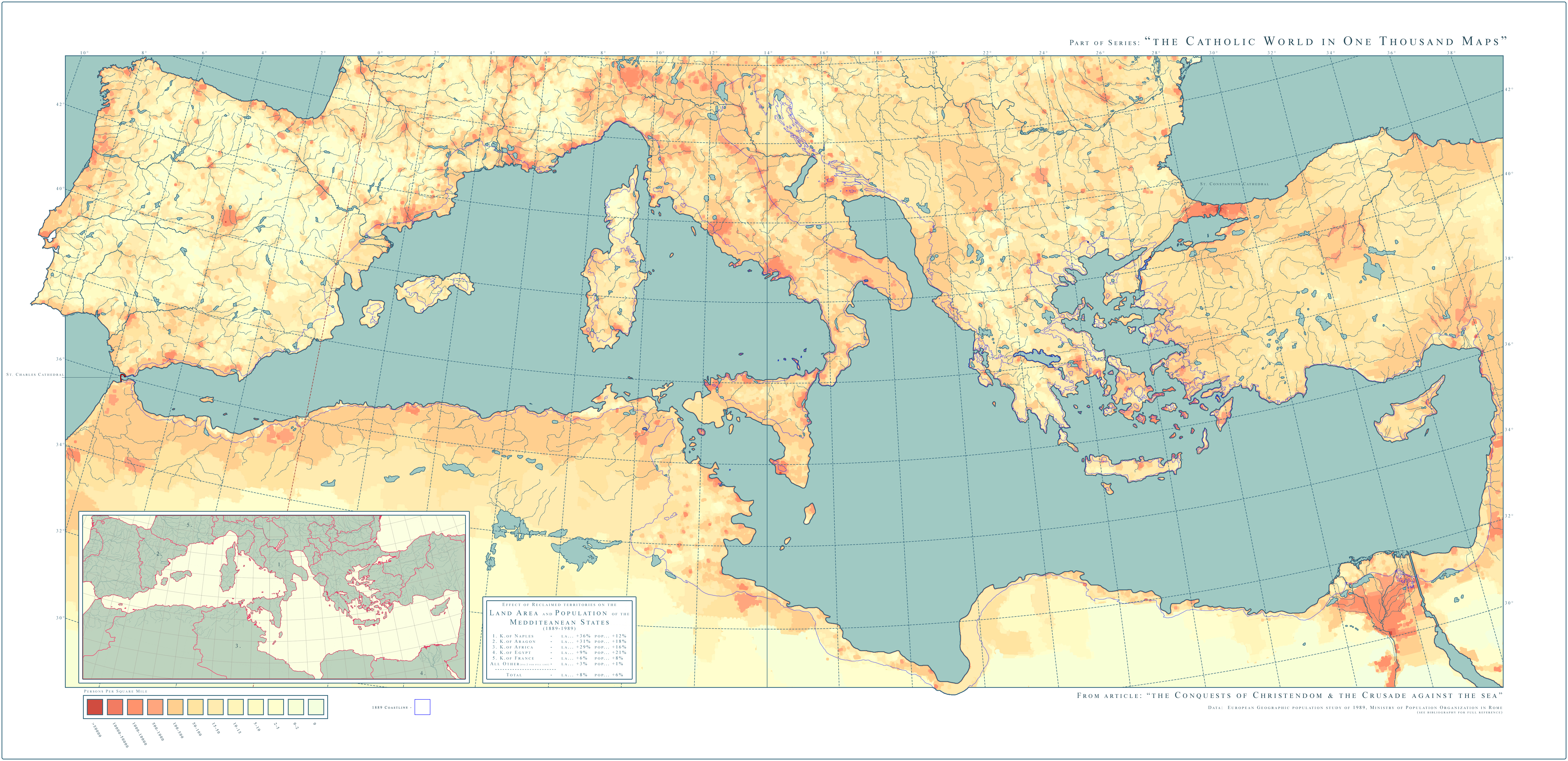
"The map of Abyssinia, and the Upper Coptic World, in 1798 AD, during the Grand Revival of the Coptic world, with Demerētia (Australia) and K'imerētia (Indonesia) recently being discovered, due to the Collapsing Europe and Muslim worlds being mostly focused on fighting each other, with the Copts being the main explorers of this world."
Map 3: @SpazzReflex

"The Demeritian Orthodox Church, est. 1749"
SpazzReflex's map went to Gokbay and Kikkomaan
List 1.1
Map 1: @Gokbay

"Ok so SpazzReflex's map was a map of Australia showing the Demëritian Orthodox Church in 1859 in communion with the Holy See of Alexandria. The names of the regions and cities on the map were not familiar to me. I tried to find out what language it was but couldn't. However the words plus Holy See of Alexandria made me think Coptic and to some extent Ethiopian. I also happened to have Historiae Mutetur in my mind and such in combination with that I thought that Demëritia was a part of an empire very much like the Southern Roman Empire from HM. I was heavily inspired by it. So I decided to make the map of the Southern Roman Empire that colonised Demëritia. Because the northern names sounded Indonesian to me I made it former Nusantaran Demëritia. Finally three cities on the east coast had names in parentheses that I was pretty sure was Japanese so I made that area a former Japanese colony."
Map 2: @TheKutKu

"It’s a Bandal/Vandal (Romance North African) map of the alexandrine Roman Protectorate (Autoritu) of what is a continuation of the semi legendary Batembuzi (Temvuzi) kingdom, a kingdom which IRL is supposed to have existed in Uganda at the turn of the last millennium, before the Kitara Empire"
Map 3: @Codae

"So the map I got took the form of an in-universe artifact, written in an in-universe language. I thought it meet to try to equal that accomplishment and end the chain on a high note. I really wanted to introduce some differentiating factors, though. So the map's not in the Vandalic that TheKutKu came up with, but some Germanic language. Nor is it an unbiased historical work, but a contemporary depiction of the subject with a nationalistic slant. See, for instance, the use of "Egypt" instead of "Southern Roman Empire": these people are fighting a war against the regime in (as was implied to me in private communication) Alexandria, and aren't going to afford them any more prestige than they have to.
As for the setting, it's eighteen years after the map I was working from, enough time for an alternative Scramble for Africa to consolidate more of the continent into world-spanning empires. Most of these empires, in my vision, are European, but I spared little thought for where in Europe the ruling nations are centered. This is a map of Africa, after all."
List 1.2
Map 1: @Kikkomaan

"Fairly straightforward, meant to be a simple depiction of trade between East Asia and the Christian West half a century before Spazzreflex's map, including the five major powers involved in said trade."
List 2
Map 1: @Uebeltank

"So this map was based on an idea of having a Muslim East Rome, but Christian Arabia and Persia. I thus made this map with a very early (7th century) POD in mind. The original map also left a lot of the world out of view, allowing for a lot of interpretation, especially with India and China and having Scythia still exist. I intentionally left most of Europe out, hoping that future map makers could come up with something cool there."
Map 2: @zalezsky
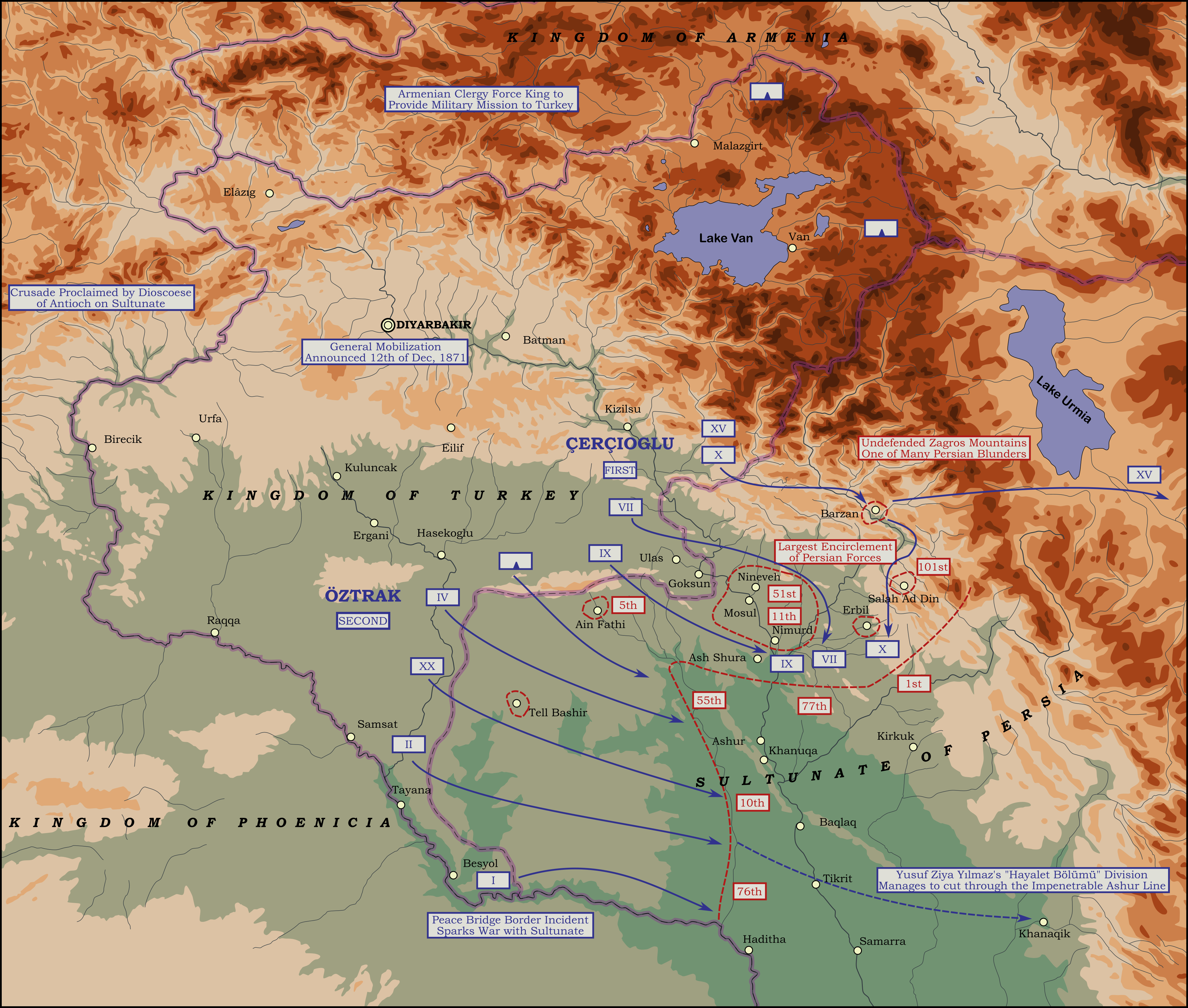
"I saw a Turkey and tried to explain how it was christian and expanded"
Map 3: @Vylon Disigma
-No description
Map 4: @OxSpace

-No description
OxSpace's map was sent to Selvetrica and Bluehot
List 2.1
Map 1: @Selvetrica

"I received a map that combined surviving crusader states with Atlantropa. Interesting concept to start. This got me thinking about how such a mega project would raise sea levels in the rest of the world and how that would effect the people. I do not know how other countries would allow such a project since it would displace so many people and cost trillions in lost property but I had to work with what I got. I decided to depict an alternate French Louisiana because the New Orleans area would be effected more than most. Since the POD was before the Americas were discovered this not anything close to OTL French Louisiana. In this time it is called Saint Louis and still has a monarch with various incorporated Republics. I wanted my map to look like it belongs in the world so I made it part of a click bait website ITTL. The title translates to "Is it time to abolish the duchies? Migration following the Mediterranean dam shows the most popular form of government in St. Louis.""
Map 2: @GustavusAdolphus1

"Well, the main things I noticed in the map I received were the risen sea levels as well as mention of the construction of a dam in 1990, so I figured the two were related. I pushed the map ahead a few centuries to account for the sea levels not being entirely the same.
The other thing I noticed were some of the colonial nations, in particular the Batavian Republic to the north. I had the idea to make it some sort of Dutch government-in-exile due to the rising sea levels consuming the Low Countries, and then I just expanded the empire to some other areas with Dutch colonial history."
Map 3: @Bennett

"I received a map of a hyper-Netherlands in the year 2200. I noticed that the Netherlands owned a huge swath of the Western Pacific, including some Japanese islands and Taiwan. I figured that, realistically, this Batavian Republic would need to have had a presence in the region before this apocalypse (and, also, I didn't feel the most comfortable doing a futuristic map, heh), so I decided to work in a world where the Dutch colony of Formosa never falls, and in fact expands. I also sprinkled in some unexplained stuff like Manchuria, Joseon, and the Ezo Republic as a jumping-off point."
CONTINUES IN NEXT POST
TELEPHONE MAP GAME: EDITION 3
Initial Map: @Entrerriano
"So for this edition I went with the first thing that crossed my mind, and that was a muslim Rome (or Constantinople) and a Christian Persia. I decided to place the Turks in Mesopotamia instead of Anatolia too, for that extra variety. In hindsight I should probably have done a little bit better, but it's OK I guess."
Entrerriano's map went to ZeSteel and Uebeltank
List 1
Map 1: @ZeSteel
"The thought process here was that I really wanted to try my hands at a munroist style map, and I think I did that well. From Entrerriano's map I saw what seemed to be a declining Roman Caliphate, so I decided to show it's collapse and give a bit of context to the rest of Europe. Hopefully this allows people to keep their options open and explore whatever avenues they desire. I had a lot of fun with the little blurbs on the different nations."
Map 2: @KolyenuKS
"The map of Abyssinia, and the Upper Coptic World, in 1798 AD, during the Grand Revival of the Coptic world, with Demerētia (Australia) and K'imerētia (Indonesia) recently being discovered, due to the Collapsing Europe and Muslim worlds being mostly focused on fighting each other, with the Copts being the main explorers of this world."
Map 3: @SpazzReflex
"The Demeritian Orthodox Church, est. 1749"
SpazzReflex's map went to Gokbay and Kikkomaan
List 1.1
Map 1: @Gokbay
"Ok so SpazzReflex's map was a map of Australia showing the Demëritian Orthodox Church in 1859 in communion with the Holy See of Alexandria. The names of the regions and cities on the map were not familiar to me. I tried to find out what language it was but couldn't. However the words plus Holy See of Alexandria made me think Coptic and to some extent Ethiopian. I also happened to have Historiae Mutetur in my mind and such in combination with that I thought that Demëritia was a part of an empire very much like the Southern Roman Empire from HM. I was heavily inspired by it. So I decided to make the map of the Southern Roman Empire that colonised Demëritia. Because the northern names sounded Indonesian to me I made it former Nusantaran Demëritia. Finally three cities on the east coast had names in parentheses that I was pretty sure was Japanese so I made that area a former Japanese colony."
Map 2: @TheKutKu
"It’s a Bandal/Vandal (Romance North African) map of the alexandrine Roman Protectorate (Autoritu) of what is a continuation of the semi legendary Batembuzi (Temvuzi) kingdom, a kingdom which IRL is supposed to have existed in Uganda at the turn of the last millennium, before the Kitara Empire"
Map 3: @Codae
"So the map I got took the form of an in-universe artifact, written in an in-universe language. I thought it meet to try to equal that accomplishment and end the chain on a high note. I really wanted to introduce some differentiating factors, though. So the map's not in the Vandalic that TheKutKu came up with, but some Germanic language. Nor is it an unbiased historical work, but a contemporary depiction of the subject with a nationalistic slant. See, for instance, the use of "Egypt" instead of "Southern Roman Empire": these people are fighting a war against the regime in (as was implied to me in private communication) Alexandria, and aren't going to afford them any more prestige than they have to.
As for the setting, it's eighteen years after the map I was working from, enough time for an alternative Scramble for Africa to consolidate more of the continent into world-spanning empires. Most of these empires, in my vision, are European, but I spared little thought for where in Europe the ruling nations are centered. This is a map of Africa, after all."
List 1.2
Map 1: @Kikkomaan
"Fairly straightforward, meant to be a simple depiction of trade between East Asia and the Christian West half a century before Spazzreflex's map, including the five major powers involved in said trade."
List 2
Map 1: @Uebeltank
"So this map was based on an idea of having a Muslim East Rome, but Christian Arabia and Persia. I thus made this map with a very early (7th century) POD in mind. The original map also left a lot of the world out of view, allowing for a lot of interpretation, especially with India and China and having Scythia still exist. I intentionally left most of Europe out, hoping that future map makers could come up with something cool there."
Map 2: @zalezsky
"I saw a Turkey and tried to explain how it was christian and expanded"
Map 3: @Vylon Disigma
-No description
Map 4: @OxSpace
-No description
OxSpace's map was sent to Selvetrica and Bluehot
List 2.1
Map 1: @Selvetrica
"I received a map that combined surviving crusader states with Atlantropa. Interesting concept to start. This got me thinking about how such a mega project would raise sea levels in the rest of the world and how that would effect the people. I do not know how other countries would allow such a project since it would displace so many people and cost trillions in lost property but I had to work with what I got. I decided to depict an alternate French Louisiana because the New Orleans area would be effected more than most. Since the POD was before the Americas were discovered this not anything close to OTL French Louisiana. In this time it is called Saint Louis and still has a monarch with various incorporated Republics. I wanted my map to look like it belongs in the world so I made it part of a click bait website ITTL. The title translates to "Is it time to abolish the duchies? Migration following the Mediterranean dam shows the most popular form of government in St. Louis.""
Map 2: @GustavusAdolphus1
"Well, the main things I noticed in the map I received were the risen sea levels as well as mention of the construction of a dam in 1990, so I figured the two were related. I pushed the map ahead a few centuries to account for the sea levels not being entirely the same.
The other thing I noticed were some of the colonial nations, in particular the Batavian Republic to the north. I had the idea to make it some sort of Dutch government-in-exile due to the rising sea levels consuming the Low Countries, and then I just expanded the empire to some other areas with Dutch colonial history."
Map 3: @Bennett
"I received a map of a hyper-Netherlands in the year 2200. I noticed that the Netherlands owned a huge swath of the Western Pacific, including some Japanese islands and Taiwan. I figured that, realistically, this Batavian Republic would need to have had a presence in the region before this apocalypse (and, also, I didn't feel the most comfortable doing a futuristic map, heh), so I decided to work in a world where the Dutch colony of Formosa never falls, and in fact expands. I also sprinkled in some unexplained stuff like Manchuria, Joseon, and the Ezo Republic as a jumping-off point."
CONTINUES IN NEXT POST
Last edited:
Results! (Part 2 and about Edition 4)
Map 4: @X_Eaglefrost_X

-No description
List 2.2
Map 1: @bluehot
.png")
""... The Pope and his Levantine allies expressed their unhappiness ... the last crusade was to be in the West."
I was considering doing a regional map of Jerusalem, but for some reason chose to do Iberia. Since I wasn't told who it was that drained the Mediterranean, I guessed it might have been the Arabs. This Spain, formed into the Holy Order of Catholic Iberia has not finished the reconquista, though its certainly due to with what Cordoban Andalusia is doing. The War of the Rock is meant to explain how Cordoba occupied Morocco."
Map 2: @Emperor Lapland

"The map I received had iberia still divided between a catholic north and a muslim south and mentioned the comission of a dam in the Gibraltar strait by the king of Andalusia. I was also sent a brief description that talked about a planned last crusade in Iberia. Considering how long it would take for the dam to be built, my guess was this crusade would happen before it was finished, and I decided to make a map of the close aftermath of the war, a bit inspired by Casablanca. The crusade ended in a victory for the catholic forces and they took control of all of Iberia, except for the city of Jabal Tariq (Gibraltar for the christians) which still resists as the last muslim stronghold in the peninsula, a safe port for the Andalusians fleeing the continent and the wrath of the Order of Iberia to safer places in Africa and the New World. My map shows the city as well as nearby muslim-controlled fortifications and the migration routes and main destination of exiled muslims. I also added the small part of the dam/wall (which is based on otl Atlantropa designs) that the Andalusians managed to build before construction was halted by the crusade."
Map 3: @Wings

"The last Map had quite a lot of info despite not showing a lot. Since Iberia was called the "Order of Iberia" and Crusdaes were mentionned, I imagined a much more brutal Reconquista. The Europeans would have pursued into Africa and further, seeking Allies such as Mali. These regions would then have been cleansed leading to Africa being partitionned into Christian Colonies as a result of a much more brutal crusading. Here is the French Colony in North Africa, flanked by the Iberian (Morocco) and Napolitan (Libya) colonies."
Map 4: @mikroraptor

"
I saw Wings's map, which suggests a early medieval POD, with the Frankish Empire and a Kingdom of Iberia. I also noticed that Christianity seems to be much more powerful ITTL. That got me wondering, what happened to other religions, like Judaism? I eventually decided that since there seems to be a powerful Church, which most likely controls the holy land, and which is probably not that friendly towards the Jews, that perhaps in this world's colonization of North America, there was a large amount of migration to, say, the lower Hudson valley, of Jews fleeing persecution in Europe. The colonists also interacted with surrounding native tribes, such as the Lenape and Haudenausaunee, and created a syncretic version of Judaism compatable with preexisting beliefs.
Eventually, this colony rebelled against the Christian nation that colonized it, in this case, England, and so did the Haudenausaunee, and the two formed Zionist states in North America, which, although highly reactionary, are fairly democratic. However, the Christian nations surrounding the Republics are extremely paranoid of them, and the republics are international pariahs."
Thanks to everyone who took part on this edition! A lot of good maps have been made, which makes me really happy.
About a possible Edition 4: I'm not going to organize an Edition 4 myself. This last edition has been a pain to keep up with, and it doesn't help that many users never answered when mentioned (multiple times even), and a lot were skipped. If anyone wants to (properly) organize a TMG: E4, go ahead, I will participate and give ideas, but I won't keep track of the game myself.
That said, these 3 Editions have been quite fun to organize and play! Thank you everyone!
-No description
List 2.2
Map 1: @bluehot
""... The Pope and his Levantine allies expressed their unhappiness ... the last crusade was to be in the West."
I was considering doing a regional map of Jerusalem, but for some reason chose to do Iberia. Since I wasn't told who it was that drained the Mediterranean, I guessed it might have been the Arabs. This Spain, formed into the Holy Order of Catholic Iberia has not finished the reconquista, though its certainly due to with what Cordoban Andalusia is doing. The War of the Rock is meant to explain how Cordoba occupied Morocco."
Map 2: @Emperor Lapland
"The map I received had iberia still divided between a catholic north and a muslim south and mentioned the comission of a dam in the Gibraltar strait by the king of Andalusia. I was also sent a brief description that talked about a planned last crusade in Iberia. Considering how long it would take for the dam to be built, my guess was this crusade would happen before it was finished, and I decided to make a map of the close aftermath of the war, a bit inspired by Casablanca. The crusade ended in a victory for the catholic forces and they took control of all of Iberia, except for the city of Jabal Tariq (Gibraltar for the christians) which still resists as the last muslim stronghold in the peninsula, a safe port for the Andalusians fleeing the continent and the wrath of the Order of Iberia to safer places in Africa and the New World. My map shows the city as well as nearby muslim-controlled fortifications and the migration routes and main destination of exiled muslims. I also added the small part of the dam/wall (which is based on otl Atlantropa designs) that the Andalusians managed to build before construction was halted by the crusade."
Map 3: @Wings
"The last Map had quite a lot of info despite not showing a lot. Since Iberia was called the "Order of Iberia" and Crusdaes were mentionned, I imagined a much more brutal Reconquista. The Europeans would have pursued into Africa and further, seeking Allies such as Mali. These regions would then have been cleansed leading to Africa being partitionned into Christian Colonies as a result of a much more brutal crusading. Here is the French Colony in North Africa, flanked by the Iberian (Morocco) and Napolitan (Libya) colonies."
Map 4: @mikroraptor
"
I saw Wings's map, which suggests a early medieval POD, with the Frankish Empire and a Kingdom of Iberia. I also noticed that Christianity seems to be much more powerful ITTL. That got me wondering, what happened to other religions, like Judaism? I eventually decided that since there seems to be a powerful Church, which most likely controls the holy land, and which is probably not that friendly towards the Jews, that perhaps in this world's colonization of North America, there was a large amount of migration to, say, the lower Hudson valley, of Jews fleeing persecution in Europe. The colonists also interacted with surrounding native tribes, such as the Lenape and Haudenausaunee, and created a syncretic version of Judaism compatable with preexisting beliefs.
Eventually, this colony rebelled against the Christian nation that colonized it, in this case, England, and so did the Haudenausaunee, and the two formed Zionist states in North America, which, although highly reactionary, are fairly democratic. However, the Christian nations surrounding the Republics are extremely paranoid of them, and the republics are international pariahs."
Thanks to everyone who took part on this edition! A lot of good maps have been made, which makes me really happy.
About a possible Edition 4: I'm not going to organize an Edition 4 myself. This last edition has been a pain to keep up with, and it doesn't help that many users never answered when mentioned (multiple times even), and a lot were skipped. If anyone wants to (properly) organize a TMG: E4, go ahead, I will participate and give ideas, but I won't keep track of the game myself.
That said, these 3 Editions have been quite fun to organize and play! Thank you everyone!
Wonderful work everyone! It was a hard round but I'm glad that we've got some pretty amazing maps!
I had a small write-up though i'm not sure how much more illuminating it is having seen where things went")
I had a small write-up though i'm not sure how much more illuminating it is having seen where things went
The Demeritian Orthodox Church, est. 1749
The Miaphysite tradition is in communion with the Oriental Orthodox Churches (The Holy See of Alexandria) and shepherds the souls of around 9.53 million people. Due to administrative issues and turmoil in both Egypt and Abyssinia, the Demeritian diocese were allowed autonomy. Archbishop Dato'ri Iusuf was elected Pope Jojyo (Giyorgis) I in 1749. Evangelizing the Native Demeritians has had mixed success, The Yolanu people have joined the church enthusiastically to benefit from trade, while the Natives of Southeast Demeritia resisting the Church with violence. The Kalkatungu Horse People near Winomo are rather average for the Demeritians: they have embraced the word of Christ, but cling to many pre-Christian traditions. Many Yenihon and K'imeritians have also begun founding settlements independent of the Abyssinian traders of the Western coasts. Mankassar K'imeritians, with their close proximity to Demeritia have been very influential, while anti-Christian regimes in Nihon and the surrounding area have been pushing migrations of Yenihon Christians to Demeritia and elsewhere in the known world.
Share: